Walks listed with the most recent at the top. There might be some overlap between moderate and challenging hikes.
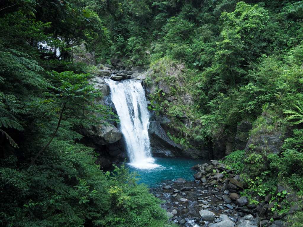
GOLDEN WATERFALL and LIUKENG SLOPE ROPEWAY (黃金瀑布/六坑斜坡索道)
This particular mini adventure in New Taipei’s Ruifang District is a brief but enjoyable walk connecting two of the area’s popular sight-seeing spots: the Golden Waterfall and Shibaoshan Lookout. If you’re feeling energetic, you could use it as a warm-up for climbing Teapot Mountain, or if — like me — your in more of a leisurely mood, you can end the walk with a pleasant sit down in one of Jinguashi’s coffee shops.
SAVAGE VALLEY (野人谷)
 This loop walk in New Taipei’s pretty Pingxi District takes you through an abandoned pleasure park, past a couple of waterfalls, and past the odd landscape of Dahua’s potholes.
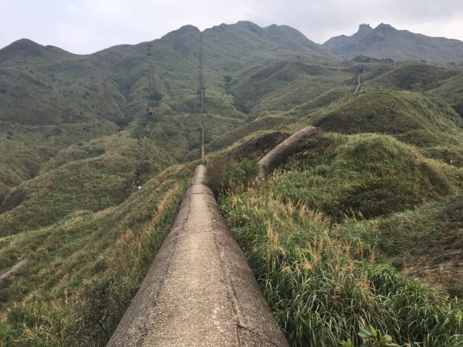
MOUNT HUOYAN RIDGE HISTORIC TRAIL (火炎山越嶺古道)
 A short trail in New Taipei’s coastal Gongliao District that greatly benefits from having a beach and a coffee shop at the end.
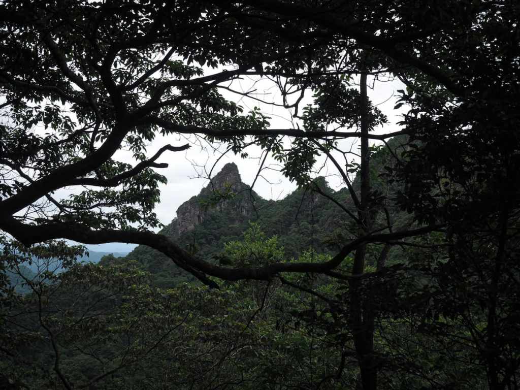
KEELUNG MOUNTAIN EAST PEAK (基隆山東峰)
Climbing Mount Keelung is part and parcel of the Jiufen experience. Most visitors take a break from sampling the town’s many and varied treats to climb the thigh-testing, lung-burning steps. Far fewer people know that there is a secret back-route that reaches the summit via a series of thrilling scrambles.
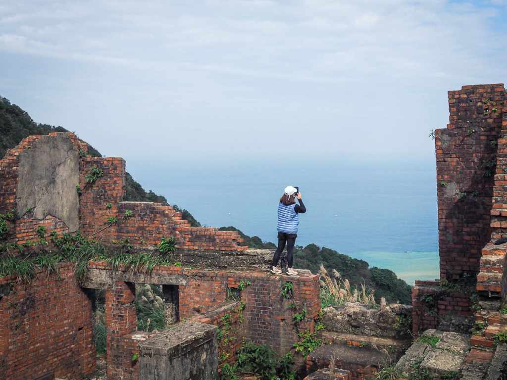
JINGUASHI to BENSHAN GEOLOGICAL PARK LOOP (金瓜石/本山地質公園O型)
 The area around Jiufen and Jinguashi is absolutely riddled with hiking trails — many of which can be found on this site. This latest addition to the collection details an easy-to-moderate walk that takes in some sites of historical and geological interest.
FISHERMAN’S TRAIL: NORTHERN SECTION (魚路古道北段)
 The Fisherman’s Trail is a historic 30-kilometre trading route connecting Jinshan on Taiwan’s northeastern coast with Shilin. This post covers the northern section connecting Qingtiangang with Jinshan.
NEIDONG FOREST RECREATION AREA TRAILS (內洞森林遊樂區步道)
 Situated on the banks of Nanshi Creek and far away from the busy city, Neidong National Forest Recreation Area is a peaceful and pretty natural haven. The park has a total of three trails — the Scenic Trail, the Forest Bathing Trail and the Waterfall Trail — which can be woven together into a single loop, allowing you to see all that the park has to offer.
DEVIL’S CAVE and STONE BAMBOO SHOOT PEAK (魔神仔洞/石筍尖)
 This odd little loop in New Taipei’s Pingxi District is a thrilling mix of climbing, views, and old mining remains.
NANYA MOUNTAIN and FRONT TEETH ROCKS (南雅山/門牙岩)
 This exciting trail on Taiwan’s northeastern coast offers hikers sea views, fun climbs, and some interesting rock formations.
YINGZAI PEAK and CHAOYIN CAVE TEMPLE (鷹仔尖/觀音山潮音洞)
 This short but strenuous walk in New Taipei’s Wugu District offers steep ascents, lots of temples, and (in the right season) cherry blossom and black kites.
YEHLIU PORT HILL and the CAMEL’S HUMP (野柳山/駱駝岩)
 This wonderful pocket-sized adventure on Taiwan’s northern coast is almost a perfect half-day hike.
FENGZILIN SHAN and NIAOYUE SHAN (楓子林山/鳥月山)
 This slightly rough-around-the-edges walk is probably not going to be everybody’s cup of tea. But if you’ve done lots of the popular hikes around Taipei and are looking for something a little quieter then this might just be the walk for you.
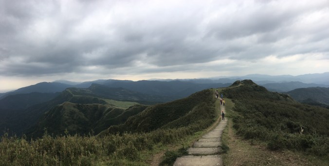
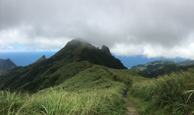
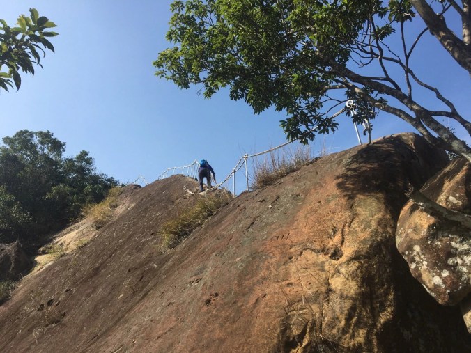
STEGOSAURUS RIDGE (劍龍稜)
 Stegosaurus Ridge has to be one of the most superlative day hikes that you can do in northern Taiwan. It offers spectacular views of grassy slopes and dramatic rocky ridges set against bright blue coastal waters, and is very much a full-body workout kind of hike.
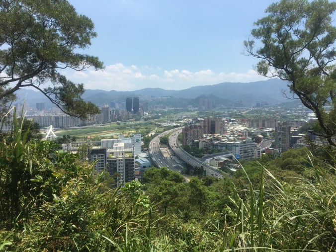
TAIPEI SKYLINE TRAIL: SECTION 10B
 This section of the Taipei Skyline Trail packs a lot of interesting spots into its not-quite-14km length. There are not one, but two Xiao Bai Yue, and one of Taipei’s most impressive land god temples.
TAIPEI SKYLINE TRAIL: SECTION 10A
 Leading from Sanxia District and on towards Tucheng, this section of the Taipei Skyline Trail was an unexpected pleasure. Gently taxing and quiet ridge line trails offer a wonderful escape from the city.
TAIPEI SKYLINE TRAIL: SECTION 9B
 Much of the Taipei Skyline Trail stitches together popular routes on the edge of the city. Not so this section, which looks like it doesn’t get many visitors.
TAIPEI SKYLINE TRAIL: SECTION 9A

This section of the Taipei Skyline Trail is unique in that it is almost a loop. It covers conjoined ridges that form a horseshoe-esque shape stretching from Sanxia, out towards Daxi, and then back to Sanxia again.
TAIPEI SKYLINE TRAIL: SECTION 7A
 Section 7A of the Taipei Skyline Trail sees you scaling Mount Guanyin the hard way, before leading you along a quieter stretch of path to the place where Taiwan’s Robin Hood (allegedly) met his end.
TAIPEI SKYLINE TRAIL: SECTION 6B
 This section of the Taipei Skyline Trail offers grand views over Yangmingshan Park’s western hills, as it takes walkers over the steep (and often) muddy peaks of the Mount Datun range.
TAIPEI SKYLINE TRAIL: SECTION 5B
 The fifth section of the Taipei Skyline Trail sees you leaving Yangmingshan Park behind and entering Keelung. This section covers a long (muddy) ridge walk between Fengguizi and the very edge of Keelung City.
TAIPEI SKYLINE TRAIL: SECTION 5A
 This section of the Taipei Skyline Trail takes you close to the coast as you explore some of the sights of Keelung.
TAIPEI SKYLINE TRAIL SECTION 4 (Short Version)
 The highlight of this section of the Taipei Skyline Trail is unquestionably the exceedingly cool temple cave close to Mount Hongdan. That aside, it involves some pleasant wandering over less-travelled paths, and passes plenty of historic spots.
TAIPEI SKYLINE TRAIL: SECTION 3

Straddling Xizhi and Ruifang Districts, Section three of the Taipei Skyline Trail offers a good workout, a few views, a historic fort, and one of Taiwan’s Minor 100 Peaks.
TAIPEI SKYLINE TRAIL: SECTION 2B
 This section of the Taipei Skyline Trail was an unexpected delight. It has the twin charms of both a fun ridge walk and a temple-studded historic trail.
TAIPEI SKYLINE TRAIL: SECTION 2A
 This section of the Taipei Skyline Trail covers one of the quintessential Taipei day hikes: the spectacular Huangdidian. Bring a camera and a well-rested body, and come prepared for a very fun walk.
TAIPEI SKYLINE TRAIL: SECTION 1B
 This section of the Taipei Skyline Trail really packs in the views. Taking you from Caonan in the east to Shiding in the west, it offers thrilling climbing and some tantalising views over the famous Huangdidian Ridge.
TAIPEI SKYLINE TRAIL: SECTION 1A
 Climbing from the cerulean waters of Xindian River, this section of the Taipei Skyline Trail takes you up to the ridge line that runs from Bitan over towards Shiding, getting steadily more rugged as it makes its way further east.
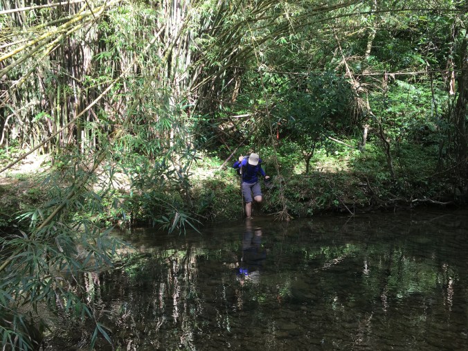
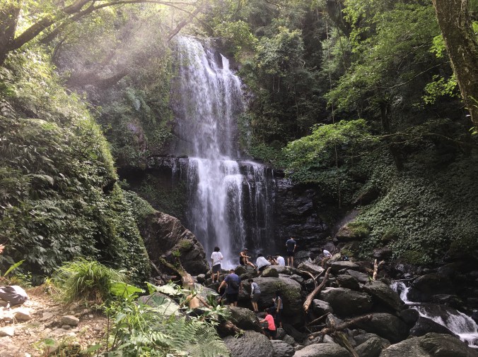
YOUKENG TRAIL and WATERFALL (幼坑步道/幼坑瀑布)
 The hills sheltering the Pingxi Line are home to countless exciting trails and waterfalls. Perhaps one of the most spectacular amongst them is the many-leveled Youkeng Waterfall.
SANXIA LION’S HEAD MOUNTAIN (獅仔頭山/粽串尖)
 Lion’s Head Mountain on the border of New Taipei’s Sanxia and Xindian Districts is one of several similarly named peaks scattered across the various counties of Taiwan. This particular lion offers excitement and adventure with a dash of history, and a visit is well worth the trouble of getting out there.
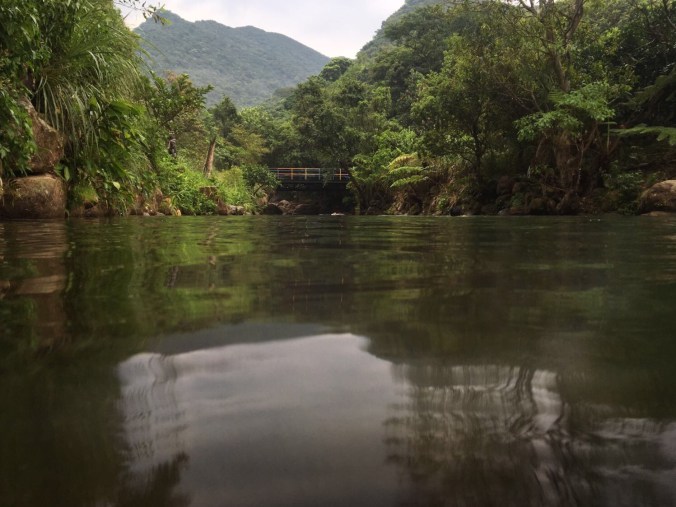
TAMSUI-KAVALAN TRAILS: WANTAN HISTORIC TRAIL and BEISHI RIVER TRAIL (淡蘭古道:灣潭古道/三水潭/北勢溪古道)
 The walk along Wantan Historic Trail and Beishi River Trail is soul-comforting waterside wander between villages in New Taipei’s sorely overlooked Shuangxi District. Bring a picnic and get ready to soak in some gently spectacular scenery.
TAMSUI-KAVALAN TRAILS: WUTUKU to PINGLIN (淡蘭古道:烏塗窟/坪林)
 The stretch of the Tamsui-Kavalan Trails that tracks over the hills between Shiding and Pinglin Districts takes you past relics of the coal industry into the heart of New Taipei City’s tea growing region.
TAMSUI-KAVALAN TRAILS: BEISHI RIVER and ZHONGKENG HISTORIC TRAIL LOOP (淡蘭古道中路:崩山坑古道/北勢溪古道/闊瀨古道/放山坑古道/中坑步道O型)
 The icing on the cake of the Tamsui-Kavalan Trails, this route comprised of five stitched together historic trails shows you some of the most beautiful scenery you can find in northern Taiwan.
TAMSUI-KAVALAN TRAILS: MUDAN LOOP (淡蘭古道北路:牡丹/燦光寮古道/貂山古道)
 This peaceful part of the northern Tamsui-Kavalan Trails traverses the slopes of the valley south of Jinguashi. Along the way you’ll pass deserted mining settlements, a tomb with a tragic tale, (or two, or three, or four), and a now abandoned dam in the middle of the forest.
TAMSUI-KAVALAN TRAILS: NEIGANJIAO to SHIFEN (淡蘭古道中路:內柑腳/十分)

The stretch of the Tamsui-Kavalan trails leading into Shifen from the south is probably the quietest section of the middle route, but don’t let that put you off. This really has the feel of a functional historic trail, leading you over the hills and across the valley from one village to another. And those who walk it south to north can reward themselves with some snacks from Shifen Old Street.
TAMSUI-KAVALAN TRAILS: FUYANG ECO PARK to SHENKENG (淡蘭古道南路:富陽自然生態公園/深坑)
 The first step on the southern span of the Tamsui-Kavalan Trails, this walk takes you from Da’an District over the hills to the popular sightseeing spot of Shenkeng Old Street. Depending on you view of the town’s famous stinky tofu this is either a perfect reward for a day of hard walking, or sore punishment.
TAMSUI-KAVALAN TRAILS: RUIFANG to SHUANGXI (淡蘭古道北路:瑞芳/雙溪)

Ruifang to Shuangxi forms part of the northern road of the Tamsui-Kavalan Trails. It passes through several rural communities and is a relatively easy route, since much of it follows established roads. It also passes the famous Jinzibei steele.
TAMSUI-KAVALAN TRAILS: RUIFANG to FULONG (淡蘭古道北路:瑞芳/九份/福隆)

This section of the Tamsui-Kavalan Trails will lead you through Jiufen and all the way to the sleepy beach town of Fulong. On the way you will get to take a wild wander over some of the less well known trails along Taiwan’s northeastern coast, as well as see traces of a rural way of life that you rarely find close to Taipei.
TAMSUI-KAVALAN TRAILS: PINGXI TOU to WAI’AO (淡蘭古道中路:坪溪頭/外澳)
 If you know anyone who isn’t yet sold on the natural and cultural delights of Taiwan, then take them by the hand and lead them to the start of this trail for a condensed highlights-reel version of everything that makes me love this charming island. This portion of the middle Tamsui-Kavalan Trails follows the footsteps of the tea-traders of yesteryear over clear streams and vibrant forests to a mountain top and the coast beyond. Along the way you’ll meet the many gods who they trusted to keep them safe on their travels, and if you’re…
GUANYIN SHAN NORTHERN CROSS ROUTE (觀音山北橫古道)
 Anyone who has hiked in Yangmingshan National Park and cast their gaze across the Tamsui River towards Bali will have noticed the multiple peaks clustered around Guanyin Shan. This trail covers many of those peaks, and is a much more interesting walk than the stone steps that also climb to the top.
YUE SHAN HU CLIFF LOOP (月扇湖大岩壁)
 Shiding is famous amongst hikers for being the starting point of Huandidian’s dramatic ridge walk, but the area has more to offer than that. Just a ten minute drive from Shiding Old Street you can find the start of Yue Shan Hu Cliff Trail – a fascinating little loop with some spectacular geology and a few traces of the area’s past life as a mining town.
ZHONGYANG PITON and CHOU TOU SHAN (中央尖/臭頭山)
 This moderately challenging walk has exciting climbs, some neat geological features, the odd dramatic view, pretty stream-side walking, and even a touch of Taiwan’s industrial history. What’s more, it can accessed by train from Taipei.
TAOYUAN VALLEY TRAIL (桃源谷步道)
 The Taoyuan Valley Trail is one of those that’s right up there in all of the listicles outlining the ‘top 10 hikes in northern Taiwan’, and whilst that means you’re unlikely to find solitude in the hills here, the popularity is for good reason. For those who prefer to follow well-marked routes and not stray too far from the beaten path, then the views offered by this trail are hard to best.
HUBAOTAN HISTORIC TRAIL (虎豹潭古道)
 A very watery wander along a pretty historic trail in New Taipei’s Shuangxi District.
BANPING SHAN AND TEAPOT MOUNTAIN LOOP (半屏山/無耳茶壺山O型)
 This is the perfect half-day hike for adventure-seekers who want to explore the many and varied delights of Taiwan’s marvellous northeastern coast.
XIONG KONG NAN SHAN and YUNSEN FALLS (熊空南山/雲森瀑布)
 This has definitely been one of my favourite hikes of the year. The walk starts with a reasonable climb through quiet and multi-layered forests to a peak that remained cool and breezy even in the summer heat. Then tracks down again to follow the playful Zhongkeng Stream as it spills and bounces it’s way through the valley. There are mountain views, grand waterfalls and even swimming holes to be enjoyed along the way. I will be adding this to my list of places to take visiting friends.
YONGHE RIDGE LOOP (國旗嶺/鄧公嶺/烘爐地南山福德宮)
 Whilst Taipei’s northern and eastern hills tend to get most of the attention, this trail to the southwest of the city has plenty to offer the traveller who strays from the well-trodden trails of Yangmingshan Park. Indeed, as the locals know, Yonghe District has well-trodden paths of its own to explore. This route takes in ancient banyans, views to both the north and the south, all manner of trail types and enough temples to satisfy the very keenest of temple aficionados.
HUANGDIDIAN (皇帝殿)
 This is the hike that made me fall in love with the trails and landscape of Taiwan. The first time I walked it was before I lived here, and the impression it made ran deep. This trail pretty much has it all: enthralling mountain views, exhilarating ridge walking, invigorating climbs and, (if you’re feeling bold enough), the opportunity to experience that famous Taiwanese friendliness by trying your hand at hitchhiking rather than walking back along the road.
YUAN SHAN HIKING TRAIL (鳶山登山步道)
 The first hike that comes to mind when thinking of Sanxia District is the ever-popular Wuliaojian trail. But if you’re not feeling up to such a tough climb, you could always set your sights on this not-so-extreme ridge walk.
DATUN STREAM TRAIL LOOP (三板橋/竿尾崙山/小觀音山西北峰/大屯溪古道)
 This loop trail takes you to a wilder edge of Yangmingshan Park that many visitors never see. The first section is a tough climb through quiet, dense forest. The mid section takes you scrambling from peak to peak through a maze of bamboo. And during the final section all your hard work is rewarded as you experience the sheer pleasure of following a delightful stream carving its way down through a luscious valley.
BIJIA RIDGE TO ERGE SHAN (筆架連峰)
 If you’ve ever travelled to Yilan on Freeway Number 5, you might have glanced right just before you entered the first of the long tunnels and seen a tree-coated ridge running towards the west. If you’re like me, that glimpse of intriguingly knobbly peaks and dips might have lead you to wonder what walking possibilities were hidden by the lush green foliage. The answer is the Bijia ridge trail – a strenuous, (but not difficult), and enjoyable trek which offers occasional great views and plenty of fun hiking.
WULAI SHAN TO DATONG SHAN (烏來山 / 大桶山)
This challenging, but exceedingly fun route leads you from one of northern Taiwan’s most scenic hot spring villages up some steep scrambles with great views over the valley. Remember to bring a towel and you can treat your tired feet to a soak in Wulai’s mineral-rich waters at the end of the hike.
FUMAO OLD TRAIL TO LONGLONG SHAN AND FULONG SHAN (福卯古道/隆隆山/福隆山)

An east coast walk on the wild side – Fumao old trail to Fulong shan follows the contours of the headland through high grass and scrubby forest all the while delivering outstanding coastal scenery and pleasantly challenging terrain.
CAOLING HISTORIC TRAIL (草嶺古道)
 This historic and very accessible trail will take you over the hills from Dali to Fulong next to an inviting river stream. Better yet, you can look forward to a refreshing swim once you have reached your destination.
WAI WA ZI SHAN TO HONGLUDI NANSHAN FUDE TEMPLE (外挖子山步道-烘爐地南山福德宮)
A ridge trail which skirts the southern edge of Taipei and takes in a couple of notable temples along the way.
XIN SHAN to DREAM LAKE and KEZILIN RIVER POOL (新山/夢湖/柯子林天然游泳池)
Excitement, adventure, great views, a hidden lake and a wild swimming pool just outside of Taipei. This is a great loop walk with all sorts of rewards for those who attempt it in the warmer months.
STEGOSAURUS RIDGE (劍龍稜/茶壺山)
An exhilarating (and rule breaking), straddling of the dinosaur’s spine. Not one for the faint-hearted.
ERGE SHAN VIA NANBANGLIAO LOOP (二格山,南邦寮山)

This short loop at the edge of civilisation offers a quick getaway from the city.
WU LIAO JIAN (五寮尖)
A very exciting full body hiking experience with great views and challenging climbs.
CUEI LAKE AND NEIGOU SHAN TRAIL (翠湖/內溝山步道)

Fun scramble through a hidden valley just to the east of Taipei.
PAOZILUN HIKING TRAIL AND SILONG WATERFALL (炮子崙步道/四龍瀑布)
A chance to test your navigation skills as you wander through hillside farmland.
