
Huangdidian
(台北天際線2段A:皇帝殿)
This was not my first time walking the spectacular Huangdidian ridge line. And I’m certain it won’t be my last. I’m really glad it was included in the route of the TSLT because a whole-Taipei route which neglected this ridge would feel like a cop-out. If you’re just in Taiwan for a short time, have moderate/good fitness levels, then I cannot recommend this route highly enough.
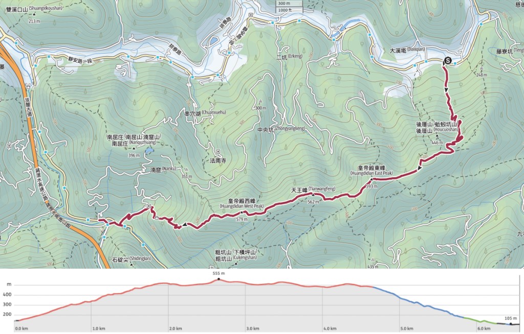
DISTANCE: 6.6km
TIME: 5½ hours at a pretty leisurely pace (except for during the descent, when I was chasing the dream of iced coffee).
TOTAL ASCENT: A little over 500 metres.
DIFFICULTY (REGULAR TAIWAN HIKERS): 3-4/10 – On a clear day, this walk is pretty easy. The steps are tiring and there are definitely places where you need to be careful, but all in a day’s walk for a habitual Taiwanese hiker.
DIFFICULTY (NEW HIKERS): 5-6/10 – I remember finding it really quite tough the first time I visited this trail. However, the difficulty was more than made up for by the excitement of the journey.
SIGNAGE: The signage is pretty good throughout. That being said, it’s quite a straightforward walk.
FOOD AND WATER: I drank about 2L on quite a warm September day. Food-wise, take snacks and maybe some salt candy.
SHADE: Most of the ridge is quite exposed, so if you’re sun-shy, you’ll want extra protection. I’d advise hands-free protection too since you’ll be needing your hands for the walking.
MOBILE NETWORK: Clear throughout.
ENJOYMENT: This hike is pure, unadulterated fun. I would do it again tomorrow.
SOLO HIKE-ABILITY: I would not advise hikers to walk this trail solo the first time they visit. (Particularly if you’re not sure how you feel about heights.) But if you’re familiar with Taiwan’s trails and know what to expect, then I don’t think there’s any reason not to do this solo.
OTHER: You’d be better off taking gloves, you’ll be grabbing quite a lot of ropes. Also, I strongly advise going on a weekday if you’re able to. The trail’s popularity and proximity to Taipei make it a very busy weekend destination.
ROUTE TYPE: Point to point.
PERMIT: None needed.
TRAILS AND POINTS OF INTEREST ALONG THE WAY:
- Shiba Peak (石霸尖)
- Huangdidian East Peak (皇帝殿東峰)
- Tianwang Peak (天王峰)
- Huangdidian West Peak (皇帝殿西峰)
- Shiding (石碇)
OPTIONS TO SPLIT THIS ROUTE: This walk couldn’t really be any shorter, but some people extend it by starting the walk from Xizhi.
Jump to the bottom of this post for a trail map and GPX file.
DIRECTIONS:
Numbers by photos refer to the GPS coordinates at the end of the post.

07:51 – On the previous times I’d walked this, I’d started my climb from Shiding, then looped back around. This time, I started from the little village of Yongding and planned to end in Shiding so that I could enjoy a drink by the water. When the bus dropped me off, it was not yet 8 o’clock and the sun hadn’t yet spread its fingers out throughout the village street. I crossed over the road to use the bus stop as a staging post, sorting out my hat, sleeves, hiking pole and everything then set off to the east, in the same direction that the bus had been heading.


07:56 – After walking about 100 metres, a big arch on the right announces the start of the Huangdidian Trail. The steps start deceptively easily…

…and going…
…but then they keep going…
…and going. (And no, you can’t escape this by starting at the other end.)


In a couple of places, the original steps seem to have been wiped out by landslides, but all of them were long enough ago that new trails have been built to bypass the collapsed sections.

For the most part, the trail is entirely covered by trees, but in one or two places, I paused to take a breath and saw views of distant views through gaps in the leaves.


The closer you get to the ridge, the steeper the steps get. At the steepest part, the steps are also alarmingly slippery. Thankfully, this section is accompanied by a low handrail. At first I looked at it and questioned the logic of attaching a rope that ran just 30cm above the steps, but it works.

09:03 – When you reach the ridge line, turn right and start the fun part of the walk. (Heading left would take you to a cool rock shaped like an eagle. It’s a walk I plan to do at some point in the future.)


As soon as you take that right turn, the steps disappear and you’re climbing a tangle of roots and ropes. At first, the views are infrequent, but be patient. They’re coming.

09:26 – The first summit along the trail is Shiba Peak (石霸尖). It has a metal marker noting it as point number six. A northeasterly window through the trees affords you a view of the elongated flat top of Mount Jiangziliao (one of the mountains visited by section three of the TSLT).


09:40 – The ridge line isn’t half as tiring as the steps, so I pushed on without taking much of a break and soon found myself at a clearing with the number five marker. Here, a side trail will take you Xiaoba Peak (小霸尖) if you’re have excess energy to burn. It’s only about 100m off the main trail, but you’ll have to descend a bit then climb both going to it and getting back.

A tree stump made beautiful both by the dappled sunlight and by the spalting pattern caused by fungi.

09:58 – Freshly added rope on the lefthand side of the trail leads towards Shibiwei Peak (石壁尾尖) and Huangdidian bat cave (written just as 蝙蝠洞). As with the nearby Eagle Rock, this is somewhere I want to come back to in the future. If it sounds interesting to you, Richard Saunders wrote about it for the Taipei times a while back. The TSLT does not go that way though, so I pressed on and kept heading straight along the ridge.


Once you’ve got past that last junction, things rapidly start to get a lot more interesting. The walking becomes more like scrambling, and the views become more frequent.

The instantly recognisable crown-like profile of Qixing Shan making an appearance from behind some trees. In fact, this portion of the trail allows you to see quite a lot of the rest of the TSLT. I was walking this as my penultimate section, so it was fun to spot all of the other places I’d passed through.

Right before you reach Huangdidian’s East Peak, there’s a little climb with one of the best views of the walk. In the photo you can see along the northeast tail of the same ridge towards Fengtou Peak (峰頭尖) and Choutou Shan (臭頭山 aka Stinky Head Mountain).

10:26 – On a weekend, you’re almost guaranteed to be sharing this spot with plenty of others, but midweek, I spent about fifteen minutes here and only saw two other people. One was a woman who was just leaving as I arrived, and another was an older chap who arrived silently carrying a machete. He clambered up onto the stone bearing the peak marker (machete still in hand), and silently surveyed the landscape for several minutes. In fact, I bumped into machete uncle a couple of times on the way down. He was making slow progress and pausing every now and then to hack at the plants that were encroaching on the path.


These views are undoubtedly one of the reasons for this walk’s enduring popularity. Whichever way you look, there are layers and layers of blue-green mountains and you feel literally on top of the world.

10:43 – I stopped for about 20 minutes, then when the time came to head on, I continued following the ridge line westwards. There are in fact two trails branching out from the western end of Huangdidian’s East Peak. Make sure you take the one which heads to the left of this rocky spine.

10:53 – As I made my way down, I passed a couple paused for snacks less than a hundred metres from the summit. “Is it much further?” they asked. They should have pressed on for another couple of minutes. At the next junction, keep heading straight along the ridge. (People doing the walk from Shiding often go to the east peak then return to walk down these steps and back along the road.)


As well as stunning views and exciting climbs, there are gentler sections of trail where shaded paths are fringed with beautiful ancient ferns. (Really, these Dipteris conjugata ferns are living fossils.)

11:04 – I took a fifteen-minute snack and drink break in a small dip in the path. It looks like the trail splits in two here, but if the lefthand trail exists, I can’t find it on the map. Stick to the right and don’t start going down yet.


11:20 – The next junction isn’t actually a proper junction. The trail seems to split in two, but the two forks are rejoined in a few metres. I took the lefthand path but…

…more adventurous folk can choose to squeeze into this tunnel through the boulders.


11:26 – This rock face has to be one of the most exciting parts of the whole walk. For the braver hikers amongst you, there’s the chance to abseil several metres down the footworn sandstone.

Since I was walking alone, I deemed it more sensible to take the easier route down the left side of the rock, but I couldn’t pass by without having a little clamber up.

11:33 – Another trail branches off to the left. As before, ignore it and keep heading alongthe ridge. (Honestly, I could make my own job a lot easier by just writing: go up steps, proceed along ridge, go down steps. But there are too many pretty pictures to share so I guess I have to write something.)


11:37 – Tianwang Peak (天王峰) sits between Huangdidian’s East and West Peaks. There’s not much space here, so after taking a picture of someone posing i the east peak, I pressed on.

11:40 – Just below Tainwang Feng, there’s a clearing with several benches, and just a little way beyond that, there’s another side trail. Once more, keep heading straight.

The trail between Tianwang Peak and Huangdidian West Peak seemed a little more overgrown than the earlier path. I guess Machete Uncle hadn’t come this way. The plants beside the trail give an illusion of solidity, but if you peer more closely into the greenery, you will see vertiginous drop-offs on either side.


At points where the foliage is not so thick, this section has distant views and exposed rocky climbs. According to Richard Saunders (the English-speaking authority on Taiwan’s trails), this ridge line used to be a far more thrilling challenge back in the day before steps were cut into the rock and the tops of ridges were shaved flat for easier walking.

This was the first time I’d walked the route in the east-to-west direction, and I have to say, I think the views in this direction may be even better.


It may take the thrill away, but it’s easy to see why the government decided to try and make this walk a little safer. Even with the railings, you want to be taking care to place your feet carefully. A slip could end badly.

12:10 – On one of the last exposed sections, there’s a view of Huangdidiann West Peak rising above an abandoned temple.

From here, the trail dips down to join a clearing. Several people were stopped for a break here. “Oh, someone’s coming. We can ask her how long it takes to get to the east peak.” It still shocks me that people do not do thorough research before heading out. I guess with popular trails like this there are a lot of people who just come because they’ve heard it’s exciting. I gave them a conservative estimate and kept going. There are actually two trails leading away from the clearing. Take the one on the right and head towards the west peak.

12:15 – The final portion of the walk is characterised by these metal ladders. There are at least five of them.

12:22 – The climbs must have been both difficult and dangerous before these were installed, since the slopes they cover are extremely steep.


Looking back at where I’d just been. On busy days you can see hikers paused on these sections to take photos.

Zoomed out to see the two sections from the previous photos in the wider landscape.

12:29 – I reached Huangdidian’s West Peak at half twelve. This was the final section with any real view to speak of, and since I wanted to get back down into the town before it became too late for coffee, I tried to pick up the pace a bit from here on.


12:40 – There’s just a brief stretch of unpaved trail and one more ladder between the west peak and the start of the steps.

12:49 – At the steps, take a left towards Nanku Monument (actually the signpost says Nanku Monumental, but I’m not sure it means that).


As with the steps on the way up, the steps at this end are long and boring. The most exciting thing that happened was that I saw (and heard) a muntjac which was making the most pathetic bleating noises rather than the usual barks.

1:17 – Finally the steps end, and the route takes a left turn down the road. The trail is flanked by two stone lions–a treatment that’s usually reserved for temples.


Despite having left the trail behind, Taiwan’s nature hadn’t finished putting on its display for the day. I was particularly surprised by the spiky red and black caterpillar.

1:23 – The road passes through an archway. Turn right and follow the river downstream towards Shiding Old Street.

If you’ve not visited Shiding before, I’d highly recommend taking some time to explore the riverside town. But…


…I was set on coffee, so I headed straight to this little shop with outside seating and treated myself to an iced latte.
From here, it’s just a short distance to the bus stop that’ll take you back to the town.
HOW TO GET TO HUANGDIDIAN TRAIL
Google Maps address: The walk starts from Yongding Village and ends at Shiding Old Street. There is some parking at both ends, but I would advise using public transport for this one.
GPS location:
- Yongding trailhead – N25 00.405 E121 41.475
- Shiding trailhead – N24 59.540 E121 39.815
Public transport:
- To get to Yongding trailhead, you need to take the MRT to either Xindian District Office or Muzha, then transfer to either the BR7 or 795 Taiwan Tourist Shuttle. You can ride either of those to Yongding Village.
- To return, board the 666 bus at Shiding and ride it back as far as Muzha (where you can transfer to the brown line) or all the way to Jingmei (where you can hop on the green line).
TAIPEI SKYLINE TRAIL SECTION 2A – TRAIL MAP
GPX file available here on Outdoor Active. (Account needed, but the free one works just fine.)
If you enjoy what I write and would like to help me pay for the cost of running this site or train tickets to the next trailhead, then feel free to throw a few dollars my way. You can find me on PayPal, Buy Me a Coffee or Ko-fi, (and if you’re curious about the difference between the three you can check my about page).

So Good review , thank you so much.
LikeLike
Glad you enjoyed it.
LikeLike
thank you for this we just did this trail based on your effusive review and are having an iced coffee on the bridge – we thought it was a great hike!
LikeLiked by 1 person
I’m really glad to hear that! This is definitely one of the most exciting trails to do in and around Taipei. I hope you enjoyed the very well deserved coffee too.
LikeLike