
Panshiyan to Sijiaoting via Mount Jiangziliao
(台北天際線:3段:磐石嶺/姜子寮山/四腳亭)
Like section 5A, this section shares part of its route with another long-distance route (long distance in terms of Taiwan day hikes at least). From the first peak until you turn off the Mount Wufen Trail, you are following Wusi Multi-Peak Trail (五四縱走, so perhaps the English should read Fifty-Four Trail or Five-Four Trail). As with many of these multi-peak trails, the name is taken from the first character of the first peak (Mount Wufen) and the first character of the (almost) last peak (Mount Sifenwei). At 22km, it’s quite a bit longer than the trail detailed here, and I imagine it must be pretty knackering.
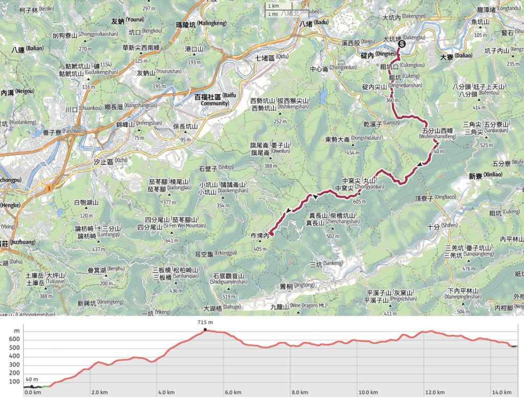
DISTANCE: 14.8km – I have to say that this one felt like longer.
TIME: 10-12 hours – I walked this in 11¼ hours, I’m sure I would have been quicker if it wasn’t so hot, and I would have been a lot slower if I’d been walking it with Teresa.
TOTAL ASCENT: Over 1100 metres. This at least feels accurate. There were a lot of ups and downs.
DIFFICULTY (REGULAR TAIWAN HIKERS): 5-6/10 – Hot conditions certainly didn’t help, but even without that, this would be on the moderate end of the scale. There are some steep rope-assisted scrambles, overgrown sections, plenty of junctions to navigate, and when considered in combination with the elevation gain, the walk is pretty long.
DIFFICULTY (NEW HIKERS): 9/10 – It’s not a particularly dangerous walk but if you’re new to Taiwan hiking, then you’ll want to get a few easier walks under your belt before attempting this one.
SIGNAGE: There’s little to no English signage, but the Chinese trail signs are pretty thorough.
FOOD AND WATER: I took 3L and finished it while I was waiting at Sijiaoting Station. Given the amount I was drinking (and sweating), salt candy was essential on this walk, and I’d say you ought to take some even on a cooler day. Food-wise, I didn’t take enough. I had nuts and a ton of congee, but I should have had maybe some fruit or something else as well.
SHADE: Patchy. I had to cover up with sleeves and a hat.
MOBILE NETWORK: There were a few sections where my mobile reception was weak or non-existent, but mostly it was ok.
ENJOYMENT: This one is definitely more about the type two enjoyment. But that being said, there are some outstanding views, several points of note, some lovely sections of forest, and (going by my experience), lots and lots of deer.
SOLO HIKE-ABILITY: I wouldn’t recommend doing this solo unless you’re already comfortable navigating your way through Taiwan’s landscape by yourself. I saw very few people all day, so it’s a very quiet route.
OTHER: I’d recommend taking a hiking stick and/or gloves. You’ll use them to grab ropes and move spiders out of your path. Given how overgrown the trail is, long sleeves and trousers would also be a good idea.
TAIWAN 100 MINOR PEAKS: No. 11 (Mount Jiangziliao) with the option to add No. 10 (Mount Wufen) with just a short detour.
ROUTE TYPE: Point to point.
PERMIT: None needed.
TRAILS AND POINTS OF INTEREST ALONG THE WAY:
- Panshihyan bus stop (盤石嶺[新巴士])
- Mount Jiangziliao (姜子寮山)
- Mount Wanggu (望古山)
- Mount Wufen West Peak (五分山西峰)
- Dingnei Fort (定內砲台)
OPTIONS TO SPLIT THIS ROUTE: You could make this a little shorter (time-wise) by heading towards Shifen down from the Tudi Gong Temple where the TSLT first joins the Mount Wufen Trail. It’s about the same distance overall, but the Mount Wufen Trail is paved the whole way, all downhill, and a lot easier to follow.
Jump to the bottom of this post for a trail map and GPX file.
DIRECTIONS:
Numbers by photos refer to the GPS coordinates at the end of the post.

06:12 – It was just me and an assortment of early-rising retirees who alighted at the Panshiling bus stop a little after 6am. I had almost missed the bus-in fact, if I’d insisted on getting the bus from the stop that I’d planned on getting it from then I would have missed it, but luckily there was another option which just meant I’d have further to walk after getting off the train at the end of the day.


I don’t really know what the retirees were planning on doing. Two went and prayed at the temple, the rest dispersed along the road, and soon it was just me and a black dog. Look out for the steps on the left just beyond the temple. Take the right-hand fork, then look out for a steep trail leading away on the right. (It’s the point in the right photo, but you can’t really see it.)

When I say steep, I mean STEEP. The trail climbs ridiculously steeply for the first 20 minutes or so. It is a very rude awakening for anyone not already rattled awake by the bus.

At least I didn’t have to wait long to get the day’s first good view. I could see all the way back down to the bend where I’d set off.

06:44 – At the top of the climb, which I think is actually Shikongdalun (石空大崙), the trail splits left and right, and becomes a little less extreme. Take the right-hand fork-the one signposted as heading to Jiangziliao Shan (姜子寮山).

The sun was still low in the sky-a double blessing because it meant that I would be doing the worst of the climbing before the day got too hot, and because it gave me some stunning sunlight like this to enjoy.

Although most of the hour between the previous junction and the next was pleasant and pretty easygoing, there were a couple of sections like this where there was some scrambling involved.


07:51 – After a pleasant hour of ridge walking, I arrived at this junction. Head straight and continue along the ridge, but prepare yourself mentally to start battling with grasses.

From here until you reach Wanggu Shan, there are many such overgrown patches. I cannot say that I enjoyed it at the time, but as is so often the case, the unpleasantness of the unpleasant sections has faded, and the beauty of the beautiful parts has lingered so that in hindsight, it seems entirely worthwhile.

I think this is the only photo I managed to take with the sun shining off the waters on the east coast. (And I managed to ruin it by getting my camera’s lens cap strap in the frame.)

Even though it meant I’d soon be climbing again, this steep descent came as something of a relief. It seemed that as long as the path was either descending or ascending, there was a clear and open trail. The only adversaries to contend with were the ever-present orb weavers, and (when I didn’t shortsightedly blunder straight into their webs), they were easily avoided with the wave of my hiking stick.
Despite the heat, the webs, the grasses and the sweat making the webs stick to my face, there were moments of quiet pleasure to enjoy. Like this natural window frame perfectly positioned to let me enjoy the many-layered hills south of my location.

08:22 – I think this junction was actually a crossroads. Head straight over and up (the right-hand path visible in this photo), and keep following the TSLT/Wusi Long Trail signage. Judging by the number of trails criss-crossing this ridge, you could walk from Xizhi and Pingxi and back again numerous times without ever having to set food on the same stretch of trail.

After the path climbed a short distance from the junction, there was another unpleasantly grassy stretch. Mercifully, this one was shorter than the last, and being able to see the fences on top of Mount Jiangzilliao at least gave me something to aim at.


08:48 – Mount Jiangziliao (姜子寮山), is another one of those “why on earth haven’t I been here yet” type of places. The views are wonderful, and it’s so close to Taipei. But I had barely even heard of it until a year or two ago. Looking south and east there are only mountains and maybe some ocean.

Looking north and west there are city views. In fact, there’s at least one more trail leading up here that I am very keen on walking. It’s a historic trail which tracks up from Jiangziliao Cliff. Teresa and I walked part of it on a ‘just exploring’ day, but turned around before going too far. We’ll have to come back.

As with most (maybe all by now) of Taiwan’s 100 Minor Peaks, this one is furnished with a metal peak marker.

09:13 – I spent a while resting here, slightly reluctant to submit myself to more of the same grass wallowing, but I had to get back down somehow, so I set off again. There are two trails leading away from here, one goes down towards Xizhi, but to follow the TSLT just take the one heading straight over and along the ridge. There is more grass… much of it high enough to reach above my head.


This section went on for what seemed for a long time and it went mostly like this: thick grass, small clearing in the shade of a tree, more grass, brief section of shorter grass with a view, more thick grass, big stone, grass, grass, grass, repeat.

09:34 – It felt like forever, but eventually I was out of the grass and under the shade of trees again. Head straight over at this junction too.

There was quite a bit of steep climbing to do, but I didn’t care. It was infinitely better than yet more grass!


In fact, there were even areas that were positively pretty–a fern-cloaked understorey basking in the warm leaf-filtered light of the trees.

10:41 – Keep straight at the next junction and follow the 四五縱走/台北天際線 trail markers (it looks kind of rightist in this picture). I had a little explore down the lefthand path before I went. There’s a little meadow area and the remains of an old stone cottage just a few metres away.

11:01 – Another several minutes’ walking took me to the next junction. The TSLT takes a left turn here…

…but first I took a 10-minute break on top of Zhongyaojian (中窯尖), aka Fan Shan (凡山). It’s only about five metres beyond the junction.


From here to the Mount Wufen Trail was probably my favourite section of this walk. It wasn’t as tough as the earlier parts, and it was beautiful. There are also many, many signs of the area having been extensively farmed or mined in the past, with lots of low stone walls snaking through the trees. Not far past where I took that photo on the right, I had my first muntjac sighting of the day. I’d heard several already, but they’d all been hiding in the undergrowth.


11:25 – After a slight incline, there are two junctions. The first is a blink-and-you’ll-miss-it turn-of on the right–go straight over. Then the walk passes through an almost cathederaleqsue bamboo grove where another side trail splits off to the left–ignore it and keep heading straight again.

Here the forest changes again and becomes dominated by Japanese cedar–the aforestation tree of choice for much of the last century. They seem to have matured into a healthier forest here than they have elsewhere. The understorey is verdant and varied and was filled with insect and bird song.
And also I saw many, many recent signs of wild boar having rooted in the area.

11:58 – There are two junctions in the cedar forest. Take a right here at the first of them.

12:11 – Then 10-15 minutes later, take a second right. This is where the gentle portion of the walk ends and it returns to being either all up or all down.

As seemed to be the standard for this particular trail, the increase in elevation was accompanied by a simultaneous increase in annoying foliage. (I know, I’m in its house and all that, it’s a bit rich of me to brand it annoying. But still…)

12:16 – The trail climbs to Ziliao Shan (荖寮山), and once more, you need to take the trail on the right. (This left-hand trail, along with the two before it all lead down to join the trails around Nuandong Valley.)

There’s yet more inevitable descending, followed immediately by more climbing. This time though, the climb at least has an obvious and enticing goal: Wanggu Crag.


12:38 – The final scramble up to the top of the exposed rock is steep, but a rope has been left to assist hikers. The trail veers to the left here, but if you visit on a clear day, it’s worth taking a moment to stop and enjoy the stupendous views from the southern side of the crag.

12:51 – Looking at the time stamps on the photos, I find it rather shocking that it took ten minutes to get from Wanggu Crag to the summit of Wanggu Shan. In my memory, it was a minute or two at the most. I guess this is the trick of the brain which gets people heading back out to enjoy this kind of type two enjoyment time and again. I didn’t spend long on the peak. By this time, the sun was beating down viciously and I was longing for shade and cool coffee. It was even uncomfortable to pick up the summit marker for a photo (despite wearing gloves) because the sun had made it hot enough to fry an egg (probably literally).


You will be pleased to know that for the remainder of the walk, there is no more overgrown grass. Just narrow but well-groomed trails through arrow bambo and forest. As I was making my way down from the peak, I met another hiker (only the second of the day–there had been one more at Mount Jiangziliao). The trail cuts down a short way then veers to the right. Ignore this turn off on the left. It’s not on my map, but there’s a marker saying that it heads towards Ziliaokeng Mining Eco Park.

A little further along I came across a pretty fresh sky lantern carcas. Unfortunately, they’re quite a common sight on the trails around Pingxi and Shifen. In fact, it wasn’t even the first I’d seen that day. But it was different to the earlier ones because it had landed right on the trail. I picked it up and decided to take it down to the nearby temple in the hopes that someone doing the easier Mount Wufen Trail could take it back down to the village.


The trail rushes straight past Dingziliao Shan. It’s little more than a sign attached to a tree. I don’t remember there being a triangulation marker or a clearing, or anything else that you’d usually associate with peaks. At the next junction you can either head straight or take a short cut to the right. The both end up in more-or-less the same spot, and since I was planning to use the shade of the land god temple as my lunch shelter, the shortcut on the right made the most sense.

13:27 – This temple sits at a crossroads, and I’ve visited it on multiple occasions. First when walking the Mount Wufen Trail, then later when walking one section of the Tamsui-Kavalan Trails. This time it was the busiest I’d ever seen it. There were two other hikers cooking up noodles, as well as a trio of government workers taking a break from cutting the grass beside the trail.One of the workers was sat on the low stone altar when I arrived, but he evidently deemed such behavior inappropriate in my presence because he immediately got up and moved. The workers were curious about where I’d just appeared from, and the other hikers were eager to fill them in. I let them chatter as I tucked into a tin of congee.

13:45 – When the time came for me to go, the worker who had relinquished his seat immediately returned to lie down on the altar. The next section was easier than what had come before in that you only need to follow the clear, paved trail as it makes its way towards Munt Wufen, but also harder in that it was relentless concrete steps with next to no shade.

I can still find beauty in trails like this, but revisiting the Mount Wufen Trail is always a strange experience for me. It’s the very first trail I wrote about for this blog, and back then I had such a limited knowledge of Taiwan’s mountains that even this massively impressed me.


14:17 – Although, to be fair to past me, the views can be rather lovely. On this occasion, I wasn’t destined to make it all the way to Mount Wufen. Instead, look out for a turning on the left close to the 2.8km trail marker. Take the unpaved trail signposted as heading towards Mount Longmen (龍門山).

14:19 – Just a minute’s walk from the main trail sits Mount Wufen’s west peak. Despite having walked past this a couple of times, I had never visited this place. The trail continues down the far side of the clearing, and (for the most part), the rest of the trail is downhill.

The trail makes its way down through more of the shady Japanese cedar forest as before. At one point there was a view over a very distant-looking Keelung Harbour. That red bridge? That is Qing’an Bridge, and it’s basically in Sijiaoting. It’s where I was headed.


The trail doesn’t have a whole load of trail markers or tags, but it’s mostly easy to follow. For a while it runs parallel to a dell, then cuts across it to run down the far side.

There were a couple of unclear junctions. The above image shows the first of them. Keep to the left of the red tag here. There’s no diverging trail shown on the map here, but there are other tags which seem to go to the left.

14:55 – Then at this next junction you need to take the left trail again.

15:14 – As it reaches a kind of saddle, the trail breaks free of the tree cover and makes its way towards a junction with a freshly installed water marker and a very old farm. A little further down the slope, I could see dogs sleeping outside a remote (still functional) farmhouse. I hoped to sneak past without disturbing them.

Follow the trail heading straight on and past the half-collapsed shell of this building. The external walls are all still evident, as is an inner wall with a doorway. It won’t be long, though, before the trees start tearing the rest of it down.

15:16 – As I had a peak inside the building, the dogs caught wind of my scent and started barking up a storm. I pressed on and away from them. A little way beyond the old building, there’s another junction. Take a left here. Remember when I said there was no more climbing? I meant there was almost no more climbing.

There are several big lumps of rock sticking out of the earth here. At the base of one of them, I found this slightly dubious-looking ramp. Just a short distance further, I met the third deer of the day’s walk.

15:41 – A little way before the summit, there’s a turn-off on the right. Ignore it and continue onwards and upwards.


15:53 – I made it to the summit feeling rather frazzled and in need of a little snack. I took about 5 minutes here to top up on a few nuts and enjoy the breeze, but it would have been even better if I’d still had some iced coffee left.

Making my way down on the far side of the summit, I was given another, closer view of Qing’an Bridge. Closer, but still, quite a way to go.


16:08 – The trail tracks down to an unmarked road. Head diagonally across it and turn up a path on the left just as you get to a large grave. There’s a little more climbing to do here, but this time I promise it’s really the last little bit of uphill.

16:15 – The trail runs up to join a wider track. Head right here.

Judging by the trailside planting and steps, this is a morning workout route for the local retiree population. This really is (I promise) the end of the climbing.


16:22 – At the top of the climb, I found myself at Dingnei Fort (定內砲台). Dingnei Fort was built in the 1880s by locals hoping to defend their homeland during the Sino-French War. (Which they did successfully manage to do.) There are many such historic ruins scattered around the hills of Keelung, and walking the TSLT has taken me to several of them.


Just in front of and down from the crumbling fortifications, there is an open area with wonderful views over the area of Dingnei and Keelung River. The trail tracks down steeply, and despite crashing down inelegantly and at speed, I encountered yet another muntjac around here, taking my total for the day up to four.

17:01 – After a small dip in the trail, I encountered a man inspecting the remains of a bird trap that he said needed to be fully removed. Mr Liu, as I would later learn he was called, is a local resident and was very keen to show me the improvements he and his peers had made to the trail. Neat signage and usefully placed benches. Their own little well-maintained corner. Take a right when you get to their shiny bench.


In fact, more than just point out trail improvements, Mr Liu insisted on giving me a pack of nuts and dried fruit, and showing me all the sights that he deemed worthy of note on the way down. Passing a pylon, he showed me the markers which indicates we were now walking on a maintenance workers’ route. At the next junction, he said that he knew the TSLT goes left, so we went left, and then he took me to see a triangulation marker just a two-minute walk away from the main trail. He was so enthusiastic about his area, it was lovely. He was also mighty fast! He had to pick up a grandchild from school, so he was working to a schedule. But after a whole day’s hiking, I lagged behind.


17:26 – At the bottom of the trail, turn left onto the road, then immediately left again once you hit the main road. We separated just before I took a right turn onto Dabu Road.

The road takes you across Keelung River. It’s not the red bridge that I’d been seeing for the past however many hours, but it’s not far from it.

17:36 – If you keep following Dabu Road, you’ll pass a few stores before eventually finding yourself at the station’s rear entrance. I had quite a wait before the next train stopped, but after such a long walk, I was just happy to be sitting down again.
GETTING THERE
Google Maps address: I started at Panshiling Temple and finished up at Sijiaoting Station. You could probably find parking at both ends, but I recommend using public transport instead.
GPS location:
- Panshiling trailhead – N25 02.425 E121 42.980
- Mount Wufen Trail Tudi Gong Temple – N25 03.765 E121 46.130
- Sijiaoting trailhead – N25 05.890 E121 45.695
Public transport:
- Getting to Panshiling – You’ll need to take the F920 bus from Xizhi (stops by the train station and Evening Market), but if you’re planning on doing the whole route, then you’re going to have to get the 5:40 service. If you catch the second bus of the day at 8:25, you will probably have to bail out by taking the amount Wufen Trail down to Shifen. (The distance looks similar on a map, but that trail is easier and quicker.)
- From Sijiaoting – Getting back from here is easy, just hop on a train. You might have a bit of a wait though since not all trains stop at Sijiaoting.
TAIPEI SKYLINE TRAIL SECTION 3 TRAIL MAP
GPX file available here on Outdoor Active. (Account needed, but the free one works just fine.)
If you enjoy what I write and would like to help me pay for the cost of running this site or train tickets to the next trailhead, then feel free to throw a few dollars my way. You can find me on PayPal, Buy Me a Coffee or Ko-fi, (and if you’re curious about the difference between the three you can check my about page).

Lovely views!
LikeLike
Hi. I’ve been following your posts since 2019 and pleased with the improving blog structuring … easy to pinpoint pertinent information for each trail.
Well, not being from Taiwan, I am confused and like to know if Taipei Grand Trail is different from this Taipei Skyline Trail.
LikeLike
Hi Kin, thank you for reaching out. And I’m really happy to hear that you’ve noticed that I’ve been trying to make the site easier to navigate. When I started this, I had no idea it would grow so big and take up so much of my free time, so the organisational element was not something I really paid much attention to in the beginning.
You’re right to query whether this is the same or different. In fact, the Taipei Skyline Trail is an almost entirely different trail to the Taipei Grand Trail. (Except for a stretch through Yangmingshan National Park, where the two overlap.) Once the posts covering all ten sections are up on the blog, (or more likely, when I find the time), I will create a separate page that will be included in the “Long Distance Trails and Challenges” section. The page will give an overview of the whole route and explain how it’s different to the Grand Trail. I also plan to add back links from each post to this yet-to-exist page.
The Skyline Trail is far less known, even in the local hiking community, and I’ve encountered plenty of Taipei hikers who assumed I was talking about the Grand Trail, when I was actually talking about the Skyline Trail. Why are the names so confusingly similar? I’m not sure, but I think it’s likely got something to do with the fact that the two trails were coordinated by different groups. The Grand Hike is a governmental initiative, while the origins of the Skyline Trail are a little less clear (at least for those like myself whose Chinese isn’t that good).
I hope this provides clarification!
LikeLike
Thanks for the clarification.
Sorry for the delay in penning this reply… due to problem buying you coffee with Buy Me a Coffee.
In the end PayPal saved the day.
Appreciate your effort … keep on hiking and keep on posting.
LikeLiked by 1 person
Thank you ever so much for that! It’s greatly appreciated, especially since it sounds like it was a bit of a hassle for you.
And I should thank you for spurring me on to find a little extra time too. After your comment of a few days ago, I decided that I ought to prioritise making a dedicated Taipei Skyline Trail page in order to avoid confusing any more people. So, thank you twice!
LikeLike