
Sijiaoting to Keelung
(台北天際線4段:四腳亭/基隆)
I had low-to-no expectations about this particular section, and decided to do it one random Sunday, almost on a whim. Well I was wrong. This is a really cool walk, and one that I can’t believe I hadn’t heard of before. Even if you have no plans to walk the whole of the TSLT, then make sure you find time to visit some of the highlights along this particular stretch of it.
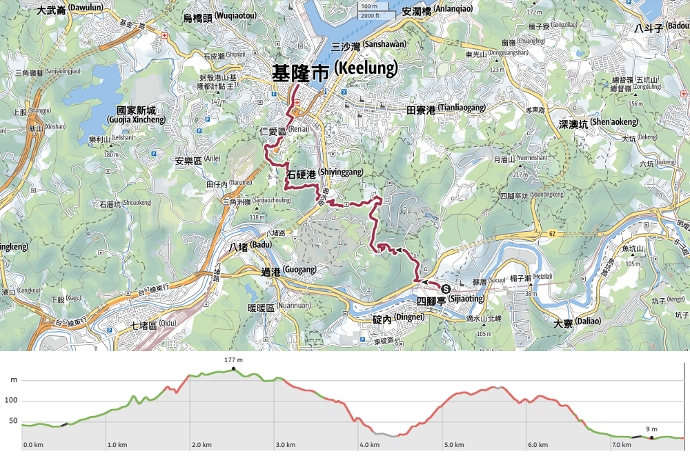
DISTANCE: 7.9km
TIME: Including a stop for dinner, this took us about 4½ hours, (so only four hours without dinner).
TOTAL ASCENT: Apparently just over 250 metres, but I can tell you that it felt like more.
DIFFICULTY (REGULAR TAIWAN HIKERS): 3-4/10 – Some abnormally slippery paths, some quite steep scrambles, it’s not always clear where you’re going, and doing this in the heat made this harder for us.
DIFFICULTY (NEW HIKERS): 6-7/10 – Part of this will feel a little too rough if you’re not accustomed to hiking in Taiwan, and you need to pay close attention both to where you’re going and where you’re putting your feet. A reasonable amount of distance and elevation gain, nothing too crazy, but the stretches of road walking can be hard on your feet.
SIGNAGE: Not so good. There were plenty of junctions without TSLT signage, and save for in a few places, the majority of the signs are Chinese only.
FOOD AND WATER: I drank about 1.5L on a hot May afternoon (temperatures pushing 30°C). Food wise we took only snacks and salt candy. There is A LOT to feast on once you get to Keelung. (We had hoped to go to the vegetarian Vietnamese place near the train station, but ended up settling for this place instead.
SHADE: Long stretches with no shade, I used an umbrella for much of this walk.
MOBILE NETWORK: Mostly clear, although there were brief moments where it became weak.
ENJOYMENT: This walk is worth it if only for the fact that it visits a really cool spot called Foguang Cave.
SOLO HIKE-ABILITY: I’d have no worried hiking this one alone.
OTHER: If you’re travelling with people who you know to be superstitious, it might be worth giving them a heads up that this walk will pass through graveyards. (My partner is sometimes ok with this, sometimes not, and she will always have something to say about it.)
TAIWAN 100 MINOR PEAKS: None, but it passes very close to Mount Hongdan which is number
ROUTE TYPE: A to B with public transport at both ends.
PERMIT: None needed.
TRAILS AND POINTS OF INTEREST ALONG THE WAY:
- Keelung Golden Ossuary Tower (基隆金寶塔)
- Foguang Cave (佛光洞)
- Eagle’s Nest military ruins aka Shiqiuling East Fort aka the Taiwanese Angkor Wat (鷹巢砲台/獅球嶺東砲台/台灣版吳哥窟)
- Shiqiuling Fort (獅球嶺砲臺)
- Shiqiuling Viewing Platform (獅球嶺觀景台)
OPTIONS TO SPLIT THIS ROUTE:
- Sijiaoting to Sankeng – just keep walking along the road to the train station after you come down from Foguang Cave.
- Sankeng to Keelung – start your walk from Sankeng Train Station, then follow the tracks back in the direction of Taipei until you join up with the walk.
Jump to the bottom of this post for a trail map and GPX file.
DIRECTIONS:
Numbers by photos refer to the GPS coordinates at the end of the post.


For the very first time I found myself alighting at Sijiaoting Train Station, I’ve passed by before, most recently while walking the Tamsui-Kavalan Trails, but this is so far the only wander I’ve done which starts from here. Pass through the ticket barrier (actually barrier isn’t the correct word, it’s just a swipe-in/swipe-out post), head down the steps, turn left onto the underpass and then take the left hand steps leading up to the station toilets and main entrance.


The station opens out onto a junction/square and from here you need to take a left onto Lane 48, Zhongyang Road, then follow the lane as it takes a sharp bend to the left. When we passed through it felt as if the whole of Sijiaoting had done their washing earlier in the morning and were hoping to let the sun dry it before the possible afternoon showers moved in.

We passed a temple with a mural about the area’s coal mining history – the miners all wearing implausibly white T-shirts.


Head straight under the Wanrui Expressway, passing the turnoff for Ruitai Bridge on your left. Then just 20-30m beyond the first junction take a sharp right onto Lane 418, Zhongyang Road.

We walked this just after a couple of weeks of persistent rain, so the channel to the right of the road was brimming with runoff, the sound of it a welcome relief in the hot sun. Keep walking until you reach the first turnoff on the left, turn onto the fenced off track and follow it as it continues uphill. There is a faded notice on the stones saying not to enter, but…from the trodden grass to the side of the concrete blocks it’s obvious that people do enter. Perhaps the note is just for vehicles. (If you’re reluctant to walk this way then it’s possible to continue along the roads then walk up through the massive grounds of Yongheng Cultural and Creative Park.)(1)


The track was slippery in the shady parts, but otherwise pretty easy to walk. We did come across this large pool of standing water that needed dodging though.
There was a brief moment of excitement early on when Teresa nearly trod on this dozy Taiwan kukri snake. After it’s close call, it paused awhile before slithering backwards and merging into the grass.

A quarter of an hour after starting on the fenced-off track we finally found our turn off. Take the steps on the left heading straight up towards some graves.

The steps very soon turn right to walk up beside the graves but you don’t want to go that way, instead make sure you keep the graves to your right and walk up until you find a trail.


The trail turns left and becomes a dirt track as soon as you draw level with the now vacant Li family tomb. (Don’t worry, you’re not going to find any zombies cruising around the forest, the Li ancestors’ bones will most likely have been gathered and placed in an ossuary which is both easier to maintain and less of a hassle to get to than a remote gravesite like this.)

It was just a little way up from here that we spotted our first TSLT signage of the whole walk, which was a relief because it was starting to feel like I’d just picked a random trail through graves.


Speaking of graves, the trail veers right, climbs a little, and then cuts through several still-occupied tombs before heading for another slippery track. (Slippery tracks were a bit of a motif for this whole adventure.) Teresa quipped, “Oh, so we’re all Chen Family now, are we?” Referencing the fact that I had just brought her out of the trees in front of the Chen family tomb…she always has something to say when I plan a walk that takes us close to graveyards (although not if she is the one to plan it…). At the top of the slippery track take a right turn.

If you pause to look back here you should spot Mount Keelung (the one that looks like a flat cone), Teapot Mountain (the small, sharp knobbly peak to the right of Mount Keelung), and the jagged ridge of Mount Banping (the one immediately to the right of Teapot Mountain). There’s so much good hiking in this corner of the world.

Turn right out of the graveyard’s lane and onto the road. The trail stays on this road for the next kilometre or so.


We passed (and ignored) a couple of turnoffs, then a bright red land god temple, this larger land god statue, and then we found ourselves in front of Keelung Golden Ossuary Tower. By this point Teresa had called her mum to show her where the silly foreigner had brought her to go walking and her mum had denounced me as being 神經病 (insane…her mum’s favourite choice of insult).

Teresa proceeded to have a more general catch-up with the family, meanwhile, I was busy enjoying the view from the complex’s car park. At first my attention was drawn by the elegant lines of Fo Xin Guanyin Yan Temple (佛心觀音巖).

And then I noticed if you look across the layers of folded mountain and forest to the most distant peak, it’s possible to see Mount Qixing. (A little left of centre in the above photo.)

We continued on, following the road downhill and round a bend. Keep a look out for these steps on the left, take them downhill, following the signs for Foguang Cave. (2)


The trail cuts just below the brick-red roofed temple that we saw earlier, and there are a number of small trails leading off on both sides. Just continue following the signs directing you towards Foguang Cave.

The trail falls in step with a stream, and the sound of water leads you down into a valley. At this junction there are two signposted routes and a third unsignposted route heading straight over. Stick close to the water and take the one on the left. At the bottom of the steps, the trail opens up a little as it draws down to meet the stream.

Then suddenly the stream is channelled under the concrete path and we found ourselves with nowhere to go except for down this square opening and into a gaping hole. (3)

I had done a little less preparation for this route than usual, just making sure I knew roughly the kind of conditions and that I had a GPX route that could be followed, I hadn’t looked at any detailed descriptions of the places passed, and as such this came as a total, thrilling surprise.At first it was hard to see anything save for the glow of lamps and candles from the altar where a golden Guanyin sat, staring into the gloom beyond. The echos of the stream – which runs straight through the cave – blocked out all outside noise and the smell of incense mingled with that of damp earth. It felt like we’d stumbled across somewhere very special.
As our eyes adjusted, it was possible to see further down into the depths of the cave. A row of old sinks had been built into one wall, and stone picnic tables had been spaced out over the staggered floor. There are steps connecting each of the level, and in some places the floor is awash, so you need to pick your way carefully over strategically placed stones.
Foguang Cave (also known as the Cave of Buddha’s Light) seems to be ridiculously absent from the English language materials that are written about Taiwan. We may have chosen to come the hard way, but it’s actually just a 25-30 minute walk from the nearest train station, and is a genuinely cool place. (Cool in both senses of the word, it was a real relief to step inside on a hot day.) According to Keelung’s government-run website, it is the largest cave temple in Taiwan and has a capacity of 1000 people – possible, although I’m sure it would be a tight squeeze. I’m not sure when it started being used as a place of worship, but the space was called into service during the Second World War, when it served as an air-raid shelter for local citizens.

To continue with the rest of the walk you have to pass down into the depths of the cavern and out via the exit on the far side. (Don’t worry if you’re mildly claustrophobic, it never feels tight or enclosed.)
Looking back at the cave once we had exited, we found that this end was marked by a large Buddha statue as well as the cave’s name. I think that on balance I am very glad that we approached it the way we did. There’s a different feeling that you get from descending down into the darkness, as opposed to walking up towards the light.


There is an assortment of smaller temples and old buildings lining the trail that leads away from the cave, and for a while we weren’t sure where we needed to go. Here the trail heads straight along a narrow lane, before veering left and passing a flight of stairs. After passing a few more old houses, the lane becomes a footpath once more.

To the right of the trail there was another cave altar, albeit a far less spectacular one than that we’d just walked through

A pavilion thoughtfully placed at the top of a flight of stairs so that people can pause awhile to catch their breath.


The steps lead down towards the hillside dwellings of Yuren Li (“Li” being the smallest unit of municipal division in Taiwan, so neighbourhood or borough). After heading through the decorated gateway take a left and continue going downward along an alleyway. (4)

Colourful undies aflutter in the noontime sun – it seemed like everyone and their dog was taking full advantage of the first true sunny day that northern Taiwan had seen in (what felt like) months, because there was barely a stretch of pavement or balcony unadorned with freshly laundered linen.


The lane comes to an abrupt end when it joins Nanrong Road, and from here you have the triple challenge of crossing a four lane road, a stream, and the railway line. First up is the road. Turn right and head for the pedestrian crossing, at the far side of the crossing you’ll need to take the covered steps leading down to join a service lane.


I did not like the feel of the service lane, all trucks and dodgy looking taxis – the kind of place where you’re likely to run into guard dogs. Turn right onto the road and head towards the city for a brief way until you spot this narrow lane on your left.


Here we crossed the second of the three obstacles, a shallow, hemmed in stream. Once you’ve crossed that, take a left turn and follow the railway’s bright blue supporting wall.

Then turn right to cut through the tunnel and with that you’ve crossed the final hurdle.

On the far end of the tunnel you’ll need to make your way over to this gently sloping track. Almost as soon as it disappears into the bushes, the pretence of it being a pleasant, easy climb are all abandoned and it reveals its true nature. (5)

This is in fact the slope of many slips. You wouldn’t know it from looking at these photos, but most of the lower reaches of the track are covered with a layer of something so slippery that it may as well be grease. Combine that with the fact that it is unreasonably steep and there is no ground to the side that you can tread on, and you’ve got an unpleasant challenge. Look out for the hiking tags hanging from a tunnel-like trail on your right. (Teresa breezed straight on past them without noticing.)

I was mightily relieved to be off the slippery road and onto something else, even if that something else was slippery bamboo-carpeted trail.


The path tracks down a way, and then back up again to this pylon all barricaded in by bamboo. The way is a little unclear here, there are multiple trails entering and leaving this clearing. Head straight up along the right side of the pylon and into the bamboo beyond. As soon as you enter the tree-lined tunnel you should take the path on your left. (I headed straight up to pay a visit to Nanrong Shan first, there’s not much to see except the triangulation stone.)
Another path which cuts through the pylon clearing soon joins and then its plain sailing on this wide, but gloomy trail through the bamboo. If I had been walking alone this place would have felt eerie.


The trail climbs steadily up, then as it starts to level off, a trail joins from the right. (I think it might go to link up with Nanrong Shan, but it doesn’t show up on the maps.) Keep heading straight following the TSLT signage. Then after dipping down to another junction, take the trail that leads kind of straight over and up again.
Tangent: The trail on the left is marked as being Nei Shi Ying Gang Old Trail, or 內石硬港古道. Naturally I couldn’t see a name like that without trying to work out where it came from, but contrary to my guess that there was previously an inland harbour here, it turns out that the Zhangzhou settlers who came to this area were in the habit of referring to streams as ports, so the Shigang Stream is divided into inner, middle and outer ports, with the inner one being close to the source at the base of Mount Hongdan. In fact, the four streams that flow into Keelung Harbour are all similarly named.

Quite honestly, when the path began to climb steeply again, I was not feeling it. I started to daydream about all the shaved ice I would eat later.

The signage at this junction is really unclear, and not all of the trails are marked on the map. You have to take a sharp left and head steeply downhill again. But…

….before you do, take the righthand spur and walk a few metres until you spot the half-cylinder husk of an old observation bunker. Standing on top of it, you can see down into the city of Keelung. The sinuous blue snake of the freeway emerges from the hillside and making its way towards our destination: Keelung Train Station. Beyond that, Keelung harbour, devoid of any of the cruise ships that I’d come to think of as being a permanent fixture, then further out to sea, the not-so-distant cone of Keelung Islet.
This whole span of Shiqui Ridge (the low ridge running northwest-southest along the inland edge of the city) is dotted with such structures – a testament to both Keelung’s strategically important location, as well as the many battles fought here over the years.


A little further down there is a triangulation marker, and the overgrown remains of another military structure. The building is almost entirely overrun by banyan trees, their probing roots having inched their way down, tracing the old arches and walls until you can see more tree than brickwork.
The complex up here at the highest point of Shiqiu Ridge was originally just called the East Fort by the Qing army who were responsible for its construction. But when the French invaded northern Taiwan, attempting to seize control of Keelung during the Sino-French War, they named it Nid D’aigle – or the Eagle’s Nest (鷹巢砲台) – in reference to its lofty position. (Evidently it has also more recently been nicknamed the Taiwanese Angkor Wat or 台灣版吳哥窟 on account of the strangler figs’ tight hold on the buildings.)
Later, when the Japanese forces landed in Taiwan in 1895, they too fought to gain control over the strategically important fortifications along this ridge.

After having a thorough look around the old military structures, we retraced our steps the short distance to the junction, then headed down the steep slope to reconnect with the TSLT. Follow the path down until you reach this junction, then take a left.

A side trail on the right leads to the remains of yet more overgrown fortifications (just a short walk for those of you who are into military history), but the TSLT continues to follow the broad track.

The trail reaches a lane, then heads straight over and up a flight of stairs.

The steps take you up to Shiqiuling Fort, one of the better-known (and better-preserved) Qing-era fortifications. On this level, you can walk through twin arched doorways into the dark interior. Inside you’ll find a central chamber with a narrow walkway running around it, and if you climb up the steps you can see the distinctive signs of this being an old gun emplacement – which would have commanded an invaluable position over the harbour. The site was previously far more extensive than this, but much has been lost to time (both physically and in terms of knowledge of who built what when), and now just the gun emplacement and command post.


Keep the gun emplacement on your right and head for the lane leading down the far side of the clearing to where the steps joined it. After a minute or two, you’ll find yourself by a pavilion with good views both out to the coast and inland.

This spot sits almost directly on top of the very tail end of Freeway No. 1 (or is it the head), and it is a very popular Keelung night view location.


Passing through the clearing, we headed on and continued downhill. At the junction in the left photo is where we deviated from the TSLT. The trail continues on and over the next hill, but our goal for the day was just to make it as far as Keelung, so that will be an adventure for next time. Follow the lane as it makes its way downhill.

Then take the lantern lined steps leading down from Shiqiuling Ping’an Temple. We didn’t stop to pay it a visit, but it has so many fascinating local stories associated with it that I feel I have to include them. The temple – which was established in the late 1700s – is dedicated to Tudi Gong, the god of the land, and some locals claim that its presence helped Qing soldiers to defeat the French invaders in 1884.
A second story associated with this place takes part during the construction of the Shiqiuling Tunnel, (this is located very close to the temple). Workers reported hearing a bell sound at noon one day. Assuming that the bell was their signal to down tools and head out for lunch, the tunnel builders all stopped what they were doing and walked back into the light. Imagine their surprise when they reached the mouth of the tunnel, only to find that there no lunch bell had been sounded. But before they could return to their duties, the portion of the tunnel that they had been working on suddenly collapsed. Many believed that it was evidence that the nearby Tudi Gong was protecting his people.
If you’re still not convinced as to the efficacy of this particular deity, there is a third story which takes place during one of Taiwan’s bleaker periods. After successfully seizing control of Keelung after their 1895 invasion, it is claimed that the Japanese took to beheading local dissidents and soldiers in the courtyard of the temple. The bodies were thrown from the ridge into a location that became known as “Tai Ren Pit” (台人坑, the pit full of Taiwanese bodies). Once the army had bumped off everyone they thought was a threat, they started preparing to burn down the temple. As it was about to be set alight, an elderly man rushed in and seized the Tudi Gong statue, rescuing it from certain destruction. Naturally the Japanese weren’t too onboard with this demonstration of bravery, so they dragged the man – still clutching Tudi Gong – into the courtyard and told him to prepare for his death. The man spoke to the statue, saying “I saved you, now it’s your turn. You save me.” And by a stroke of luck – or divine miracle – the soldier’s sword merely sliced through the top of the old man’s hat. Even more fortuitously, no one noticed that the old man had survived the ‘beheading,’ and when his body was thrown off the ridge and into the pit, he escaped with only minor injuries.
Who can say how much of these tales are based in truth? Maybe no one, but they exist and are therefore worth telling.
It’s also worth noting that, sadly, this temple does not welcome visitors unless they pay to light incense.


From the temple, follow the steps down to a carpark, then head straight over and down more steps. Cut diagonally across the lane in the right photo, then down the steps on the far side. (6)


The lane leads you through a red and orange temple paifang towards the main road, but just before you hit the road, you need to duck back down to the left and follow the tiny lane running between the houses and the raised dual carriageway.

The little lane eventually spits you out in the busy streets of Keelung, and you can more or less just follow the raised road all the way to the station. This section closest to the hills was buzzing with people on a Sunday afternoon. I’m not sure if the air quality is really at healthy levels to be doing excercise, but I have to commend the authorities for having so neatly utilised the space. We passed no less than four basketball courts slotted tightly into their own little spots, as well as a skatepark, a couple of calisthenic exercise areas, seating areas filled with old guys playing chess, people hanging out with their dogs, teenagers dancing, and a couple of families with their own portable badminton nets. They’re really getting their money’s worth out of the place.


Keep following the raised road until you can’t anymore. Take a left onto Chenggong Road, then the very next right onto Lane 118. We briefly detoured here to see if the vegetarian shop in the wet market was open, but it wasn’t, so we pressed on.

Take the underpass to cross back under the tracks for a second time.


Then on the far side of the railway you will cross over the river once more. In the photo Teresa was berating a night heron for pretending to be a penguin (we had recently rediscovered the news from a couple of years ago about the Taoyuan police responding to calls from a member of the public to report that there was an escaped penguin by the river in Nankan District). Take smaller of the two roads on the left (Zhongsi Road), and follow it round as it makes its way towards the station.

We took another detour first (for an early dinner) before making our way into the station and boarding a train that whisked us back to Taipei (for dessert).
HOW TO GET THERE
Google Maps address: We started this walk from Sijiaoting Train Station and finished at Keelung Train Station. There is parking available nearby in both cases, but it doesn’t make sense to use your own transport.
GPS location:
- Sijiaoting trailhead – N25 06.415 E121 45.420
- Start of the Foguang Cave Trail – N25 06.945 E121 45.075
- Foguang Cave – N25 06.870 E121 44.905
- Exit from trail after descending from Foguang Cave – N25 06.910 E121 44.665
- Start of trail leading to Eagle’s Nest – N25 06.955 E121 44.535
- Trailhead close to Ping’an Temple – N25 07.370 E121 44.055
Public transport: This route is very well served by the rail network. You can take any local train leaving Taipei for Su’ao and alight at Sijiaoting, then return via any train leaving Keelung bound for Taipei. If you want to break this up into two halves, it would be possible to get a train from Sankeng Station after coming down from Foguang Cave.
Further reading: The unique walking tour organisation, Keelung for a Walk has some great information about some of the sites visited on this walk. In fact, I’ve never worked with them, but their website seems great, and if you’re looking for an unusual tour to try, they look like they’d be a good bet.
TAIPEI SKYLINE TRAIL SECTION 4B – TRAIL MAP
GPX file available here on Outdoor Active. (Account needed, but the free one works just fine.)
If you enjoy what I write and would like to help me pay for the cost of running this site or train tickets to the next trailhead, then feel free to throw a few dollars my way. You can find me on PayPal, Buy Me a Coffee or Ko-fi, (and if you’re curious about the difference between the three you can check my about page).

Hi again.
Wonderful reading this latest addition, especially Foquang Cave (existence of which I was unaware before). I get nostalgic over the mention of Mt Keelung, Teapot Mt, Banpingshan and Mt Qixing, my favourite climbs in the area.
I immediately jumped to TSLT Main Page link when I came to it, that’s definitely a new page and a well deserved depository for the Skyline Trail.
I’m thrilled with the tease of Sections 5A to 10B, yet ambivalent about reaching the last article … cold turkey after that, hmmm 😉
LikeLiked by 1 person
I hadn’t heard of that cave either prior to walking this. It was such a neat surprise! And don’t worry, there’s no need to go cold turkey. I could rest for a whole year and still post one new walk per week. (I got very behind for a couple of years!)
LikeLike