
Xiaoyoukeng to Tamsui
(台北天際線第6B段:小油坑/淡水)
Despite the name given to this section in Chinese, the sixth section of the TSLT runs between Fengguizui in the east and Guandu MRT Station in the west. Along its course, it takes in some of the grander peaks of Yangmingshan National Park and offers spectacular 360° views. This post details the second half of section six.
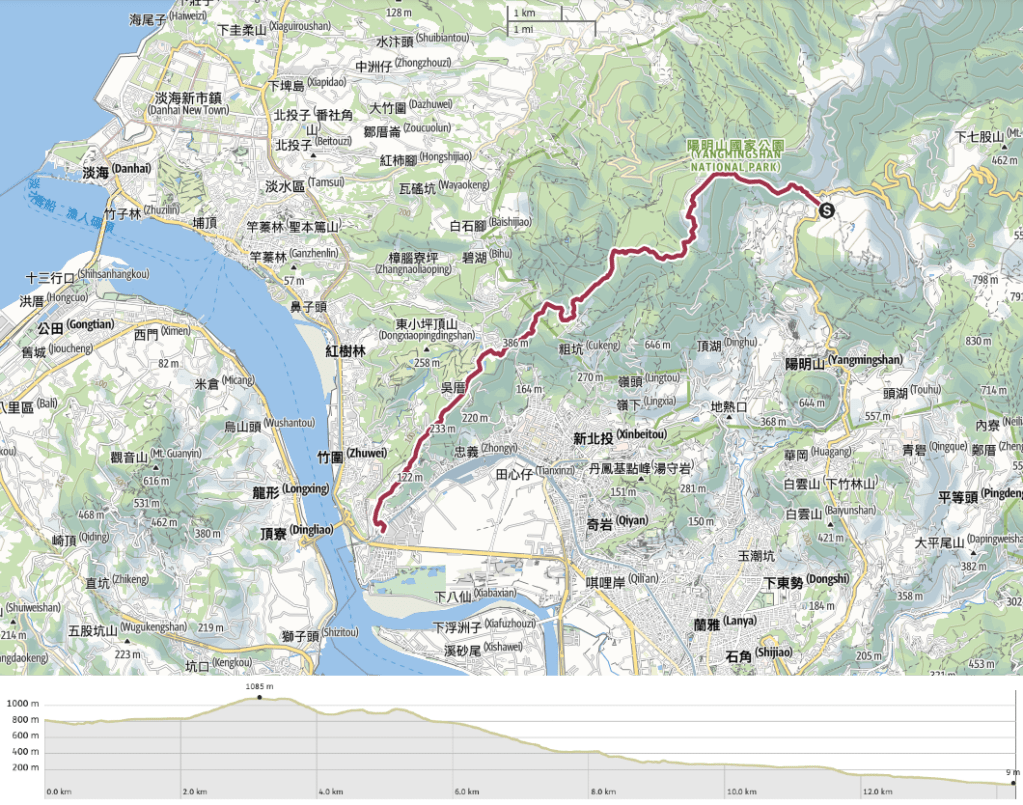
DISTANCE: 14.3km
TIME: It took me around 5 hours without much time spent resting. You’ll definitely want to budget extra time if you plan to do the trail in reverse, since the elevation gain would be significantly more if you were walking up from Guandu.
TOTAL ASCENT: 815 metres or thereabouts, (total descent is well over 1000m, so it’s tough on the toes and joints).
DIFFICULTY (REGULAR TAIWAN HIKERS): 3/10 – There are some steep ascents/descents over slightly rough terrain, and where the terrain isn’t rough it is unforgivingly hard stone steps. It’s also quite long.
DIFFICULTY (NEW HIKERS): 5/10 – For the same reasons listed above. There are short steep sections requiring the use of fixed ropes which will definitely provide the greatest challenge to new hikers, as well as some slippery ground to cover on the way down.
SIGNAGE: There’s next to no Taipei Skyline Trail signage along this section (although you may spot a sticker or two added onto fingerposts here and there), but all of the major trails are clearly marked in both English and Chinese. Things get a little less clear as you get closer to Guandu, but by that point it’s easy enough to just keep heading downhill.
FOOD AND WATER: I was ok with two bottles totaling one litre which I filled up at Qingtian Temple, although on a hot day I should probably have been carrying 1.5L just in case the water machine wasn’t working. Food-wise make sure you prepare snacks and salt candy to help replace salts lost in sweat.
SHADE: There is on-and-off shade for most of this walk, I needed sun protection in the form of a hat with a neck cover and long sleeves.
MOBILE NETWORK: Generally ok, but the stretch down from Datun West Peak to Qingshui Temple is a little patchy.
ENJOYMENT: Some stunning views and fun walking (if you like hills – obviously I do). The western edge of Yangmingshan National Park is a little less busy than the central area, so if you prefer to get away from people this might be a better bet (although even on a weekday you’re unlikely to be alone on the trails).
SOLO HIKE-ABILITY: This section follows well-defined and clearly marked paths the whole way, so most people shouldn’t have too many worries about walking it solo, just be extra cautious on the steep slopes around Mount Datun.
OTHER: I found it helpful to have a hiking stick for the steep and slippery descent. Some people like to wear gloves for the roped sections, but when they’re this short it’s not strictly necessary. Also, if you want to see the beautiful sea of silvergrass, try visiting between November and January.
TAIWAN 100 MINOR PEAKS: No. 1 (Mount Datun)
ROUTE TYPE: Point to point.
PERMIT: None needed.
TRAILS AND POINTS OF INTEREST ALONG THE WAY:
- Anbu Trail (鞍部步道)
- Mount Datun (大屯山)
- Mount Datun Siuth Peak (大屯山南峰)
- Mount Datun West Peak (大屯山西峰)
- Qingtian Temple (清天宮)
- Guizikeng Trail (貴子坑步道)
- National Taipei University of the Arts (國立臺北藝術大學)
OPTIONS TO SPLIT OR COMBINE THIS ROUTE: The route detailed here could be split into two sections, or it could be combined with all/part of section 6A.
- Bailaka Road Intersection to Qingtian Temple – about 7.5km and included almost all of the ascent and difficult walking.
- Qingtian Temple to Guandu MRT Station – about 10km, mostly downhill and not nearly as interesting when done by itself.
- Fengguizui to Guandu MRT Station – nearly 31km in total, I walked this whole route in about 11½ hours, but I wouldn’t recommend it unless you’re familiar with these trails and/or used to covering long distances and/or enjoy challenging yourself in painful ways. If you’ve not done much walking within Yangmingshan National Park before then I recommend that you take your time and enjoy it rather than rush to cover the miles.
Jump to the bottom of this post for a trail map and GPX file.
DIRECTIONS:
Numbers by photos refer to the GPS coordinates at the end of the post.

13:26 – Starting from the Bailaka Road Intersection bus stop take the paved trail located at the apex of the bend (signposted as being Bailaka Highway Pedestrian Trail).

Bailaka Road itself is a relatively modern road (given the fact that Yangmingshan has been exploited for centuries), only built in the 1950s, but the route has been in use for over two hundred years. In its earliest iteration, locals used the trunks of tree ferns to form steps totalling 162 in number, and these wooden steps were later rebuilt using stone. Its believed the current name – Bailaka – comes from the name given to that earlier trail: 百六甲 (bǎi liù jiǎ).
This little stretch of trail made me a little sad. It’s clear that people travelling on the road above often throw things out of their car windows and down the slopes. A fair amount of it is visible from the path.

After a while, the trail rises to follow the road again and I was greeted with this great view of the Xiaoyoukeng fumarole steaming above the terraced farmland of Zhuzihu. Between March and May each year the little parcels of land are dotted with elegant white calla lilies, then from May to June the pastel blues and purples of hydrangea flowers paint the landscape. Looking at it on this occasion, it seems like only rice and a few other vegetable crops were ready for harvest.

The path only tracks alongside the road for a short way before leaving it once more. Here I decided to stick with the road instead of the trail. (A choice made only because I had already walked about 14km and had another 14km left to go and couldn’t face the thought of any unnecessary ups and downs – if you’re just walking this section of the trail, then it would almost certainly be more pleasant to take the trail.)

Regardless of whether you choose to take the trail or the road, they both join up once more by the gates of Anbu weather station. Keep heading straight along the road until you reach Anbu carpark.

13:50 – The car park is the jumping-off point for one of my favourite day hikes in the national park – Xiao Guanyin Shan – but on this occasion that wasn’t where I was headed.
Turn left onto Anbu trail – if you’re curious as to why everything in this little pocket of the park is called Anbu something-or-other then it might help to know that “anbu” (鞍部) means “saddle” (as in the geographical feature), and this location is the saddle between Mounts Datun and Xiao Guanyin. fortunately for tired legs that means you can expect a steep climb.

I took a short break in the clearing at the bottom of the steps, my energy levels were flagging a little and I decided it was time to crack out the tinned congee. Hungriness sated, I set off once more up the steps (there are actually two trails here, but one of them just follows the road). Seemingly endless stone steps guide the way up Mount Datun. Two further side trails connect up to the weather station’s service road, but ignore them and keep following the steps (unless you’d rather have a less steep, more scenic, but also much longer climb). In parts where the trail runs straight all of the angles are quite dramatic.

Next to the path, I spotted piles of spirit money as well as a couple of boundary markers separating Taipei City (left of the trail) with New Taipei (on the right).

Whilst the lower half of the trail is predominantly shrouded by arrow bamboo, the upper half was entirely overgrown with just-blossoming miscanthus (more commonly known here as silvergrass or 芒草). It was impossible to walk through without being repeatedly smacked in the face by fluffy seed heads.

14:32 – The trail climbs up to a point, beyond which is part of the Datun Observatory – a squat concrete building surrounded by a mesh fence.

When you join the track outside the observatory there is only one way to go – towards the main service road, and once on the service road turn left and follow the road until it runs out.
But first, it’s worth pausing to take in the view from the observation platform. I visited in almost the best possible weather, the only way it could have been any better is if I had been there to see the sunset. From this angle, Mount Datun’s western peak looked dauntingly hilly, the only positive being that I had no plan to scale Miantian Shan (the one with the square shape on top of it).

14:46 – The summit of Mount Datun is occupied by a weather station, but there is another viewing platform here which gives you grand sweeping views in every direction except the one I had just come from.

You get a clear line of sight south over the city, here Keelung River and Tamsui River are separated by the bottleneck which marks the entrance to the tip of the erroneously named Shezi Island.

Turning eastwards there is a far-off view of Qixing Shan and the Xiaoyoukeng fumarole. Strangely, Taipei’s highest mountain looks almost small from this angle.

Take the steps cutting down into the bamboo by the side of the viewing platform. You’ll need to pay attention to where you’re putting your feet, but make sure to stop and look at the view every now and then. In this photo, you can see the tip of Shezi Island just about Mount Datun’s west peak.

There were few people going in the same direction as me, I get the impression that the majority of hikers prefer to walk this trail so that they end up by Mount Datun because the steepness of the steps is really quite punishing for tired legs.

14:59 – At the junction take a left turn following signs for Mount Datun’s south and west peaks. There is a big sign here with warnings saying just how dangerous this trail is – if you’ve done much hiking in Taiwan then you can take this with a pinch of salt (it’s not anything like Huangdidian or Wuliaojian for example). I guess that the trail’s location in a city-adjacent national park means that the authorities feel the need to be more cautious.

It was a relief to find myself once more on a dirt trail, although the amount of soil erosion that has occurred since my last visit provides a compelling argument for having maintained trails in high-traffic areas like this.

The climb to the south peak is a gentle warm-up for what to expect on the west peak, and I enjoyed the variety of plant life to be seen along the way.

15:12- The peak offers a similar southwards view to the one from Mount Datun’s main peak, and on good weather days you can expect to see layers of mountains stacked up behind New Taipei’s city limits.

Despite the visual calm of the scene, the wind up on the summit was ferocious and I couldn’t stay long. There’s only one other trail leading away from the peak so you can’t go wrong here. The trail makes use of fixed ropes to help get you down the steeper sections.

In a couple of short parts, it’s almost vertical, but in these spots, there are ample ropes, handholds and footholds which make it easy to navigate. As I was heading down this section I met a woman and her toy poodle making their way up. The poodle was bounding up with a grace and agility that I can only ever dream of demonstrating.

15:21 – At the end of the steep portion turn right onto a flatter trail. (The left trail has a sign saying that it’s closed, but it’s clear that not everyone heeds this information since the path is defined and looks reasonably well trodden. It heads on towards either Xiaotun Shan or Yongkanliao Stream depending on which branch of the trail you take.)

15:27 – There is a brief and welcome flat portion of trail before it arrives at another fork. Take a left here and follow the sign onwards towards Mount Datun’s east peak. (Right would take you towards Erziping.) Strapped to the tree to the right of the fingerpost was a trail camera belonging to a university – after looking up the department online it appears that they’re doing research into the impact of tourism in the park.

The trail runs flat for what seems like an unfairly short time before beginning to climb once more. This is by far the steepest section of trail and the most physically demanding. After starting my walk before 7am I was starting to tire, but the fact that this was also the final climb helped to buoy up my flagging energy.

15:41 – After a last concerted effort, I made it to the top of the west peak. This one (as well as the south peak) has markers that people wishing to complete the Taipei Grand Hike are meant to photograph if they wish to be awarded a completion certificate.

Once more I was propelled onwards and downwards by the wind. The many steep peaks of Guanyin Shan can be seen rising from the far bank of the Tamsui River estuary, with the flat land of Linkou and Taoyuan stretching away behind it along the coast.

The trail from the summit heads down steeply (although less steeply than I remember it climbing when I did the walk in reverse). Halfway down I almost stepped on a pair of wasps sucking the juice out of a recently deceased caterpillar.

15:59 – After 15-20 minutes of descent I found myself joining the trail coming from Erziping (a much gentler walk than the one documented here). Turn left at the junction and walk along another flat section of trail through a beautiful green tunnel.

At the end of the flat section, the path turns to stone steps once more and my poor tired feet protested. There are a couple of side trails leaving on the right, both of which will take you to Xiangtian Pool, but ignore them and keep heading down following signs for Qingtian Temple Trail Entrance.

16:13 – A landmark on the (seemingly endless) downwards steps is Sansheng Temple (三聖宮), and if you have the time for it there are quite a few old ruins in the trees just to the left of the trail that are worth an explore if you like that kind of thing.

Ugly pipework aside, this trail is quite pretty, particularly in atmospherically foggy weather or when the dying rays of the sun paint it in golden hues as it did on this occasion. Slender stalks of bamboo arch over the steps and the leaves silky dried leaves whisper underfoot.

Gradually the land beside the trail becomes increasingly agricultural, maintained bamboo groves and little pockets of farmland let you know that you’re drawing closer to civilisation. Once more keep heading down the main path towards Qingtian Temple.

As you near the end of the path make sure to glance to your right for a great view over Guandu plain.

16:34 – The last landmark you’ll pass before arriving on the road is Qingshui Temple (清水宮), instantly recognisable by its red cladding, white horse and grand views. I’ve visited here at seven in the morning, at sunset, on clear days and on foggy ones, it doesn’t matter what the time or the weather is, there are always old folk sitting at the tables in the courtyard sipping tea and watching the busy people in the city.

16:37 – Keep following the steps until they run out, then turn right onto the road and walk down towards Qingtian Temple. The temple has a water dispenser and sinks where I filled up both of my water bottles and rinsed my face. (There are also toilets too.)

The majority of walkers will stop here and catch the bus from Qingtian Temple back to Beitou, but I am a masochistic idiot completist, and I wanted to complete the whole of section six in one day and so I pushed on. Take the road heading downhill opposite the temple.

16:42 – At the next junction keep heading straight downhill on what looks like a short dead end (it is a dead end if you’re a car, but not for pedestrians). At the end of the road walk down the steps then turn right onto Alley 16, Lane 521, Fuxing Road.

16:48 – There is just a brief section of road, and it has a pretty good view over Guandu to keep your mind off of your tired feet. (Also keep an eye out for the burial urn that has had its own little niche constructed in the road wall. At the junction turn left and follow the signs for the Taipei Grand Hike.

Maybe 10 metres further along the road you’ll find the turn-off for the next section of trail on your left. The steps cut down between farmland where I passed a couple of older gentlemen tending to their crops and having a high-volume conversation by yelling at each other from their respective patches. There’s one turn-off on the right, but just keep following the steps down as far as they go and then take a right once you’ve reached the bottom.

It’s clear from the presence of several houses in varying states of decay that this little community used to be bigger – I guess people who work in the city don’t fancy having to commute from the mountainside, and so only old people seem to inhabit the remaining buildings.

Once out of the hamlet, the path winds its way gradually downwards through scrubby forest with occasional views through gaps in the tree coverage on the left.

17:02 – Not long after passing through the village I arrived at the irrigation canal which marks the TSLT’s intersection with Guizikeng Trail. Turn right here and follow the course of the canal for a while.
(If you’re collecting ‘post photos’ for the Taipei Grand Hike, then you’ll find one of the posts at this junction.)

The canal section is pleasant, although not a patch on Pingding or Dengfeng canals in terms of prettiness.

The final little part of the Guizikeng Trail sees the majority of the water being siphoned off into ugly piping as the path skirts an area of farmland, but I was lucky enough to be mostly blinded to the ugliness by the setting sun.

17:13 – Pass the pavilion and keep going straight past the turn-off on the left. When the trail ends, turn right onto a rough track (there is Taipei Grand Hike signage to point you in the right direction).

The trail curves left and cuts across the front of the driving range. It certainly doesn’t feel like it’s somewhere you should be walking, but it’s definitely the right way.

17:18 – Further compounding the impression that you’re going astray is the fact that the track is a dead end leading up to this short section of blocking fencing. I had only walked this part of the trail once before, and that time I was coming from the opposite direction so I had to stop to double-check that I really was on the right track, and yes, I was. Follow the worn trail through the grass to the side of the fence.

On the far side of the fence, you’ll find yourself walking on Daoxiang Road (稻香路). Turn left onto the road and follow it downhill for a little shy of a kilometre. It’s not the busiest of roads, but cars seem to travel quite fast and there isn’t any pavement so make sure you keep well to the side.

17:29 – Where the road reaches a sharp bend you’ll need to cross over and make for the sheltered Wuzaicuo bus stop.

Once you’re at the bus stop you’ll see this gated entrance to another track. Again it feels like you ought not to be going this way, but the gate is there to deter cars rather than people and you can just walk around the gate via the path on the left.

It’s an unusually flat bit of path for Taiwan and reminds me of some of the converted old railway tracks that you can find fanning out over the British countryside.

17:38 – The track runs out and the trail turns left onto a patch of trimmed grass. This point is the apex of the short loop of Zhongyishan Trail, so there are two exits leading away from the clearing. Don’t take the one that’s straight ahead, instead follow the trail which cuts right across the front of a massive grave (where the green T-shirt guy is walking).

Before you do, you might want to take a very brief detour to this shrine on the left. It doesn’t seem to have a name, and the crowded-in nature of it reminds me of some of the shrines I saw around Hong Kong which looked to have been set up purely to house abandoned or damaged idols.

There are two grand graves in the clearing, one of which houses He Kuo-hua, an overseas Chinese businessman and investor made wealthy by his dealings in the shoe and sugar industries during the period of Japanese occupation. The other grave is occupied by his mother.

It was really getting quite dusky by the time I left the clearing and headed down the final stretch of trail (although it was not quite dark enough to warrant getting my headlight out).

17:48 – I reached the road almost at exactly the same time that the sun was meant to be setting, and the street lights were already starting to flicker into life. From the trailhead cross over and turn left down Xueyuan Road keeping the tennis club buildings on your left.

17:51 – Once you get to the top edge of the campus belonging to Taipei National University of the Arts’ you can choose whether you want to follow Xueyuan Road all the way down or whether you want to walk through the campus. I was hoping to score an ice cream from the on-campus convenience store, so I took a left turn just past the red car and followed the pedestrian road through the university grounds.

If you visit before dark I’d definitely recommend you come this way. The campus has a sculpture park right at its highest extreme, there are some great views to be had from near the running track, and even a family of water buffalo that hang out on the lower meadow.

The higher of the two (mostly) pedestrian roads through the campus terminates here and rejoins Xueyuan Road so I took the steps which take you down to the lower road (and the convenience store and ice cream).

Once on the lower road turn right and keep heading downhill towards the main entrance to the university. There’s a lot going on here and it seems that there are frequent exhibitions/performances to be enjoyed if you’re close enough to come often.

18:20 – Ice cream was bought and inhaled within minutes (by this point I had been walking for almost 12 hours, so I did not care how undignified I looked whilst doing it). Just keep following the main road through the campus all the way down until it eventually joins Zhongyang Road, Section Four. Cross over and head left for maybe 60m, then take a right onto Lane 583.

18:24 – As you can see from my crappy camera work, I was quite tired by the time I made it to the MRT station. I spent my first post-level-three-lockdown MRT journey standing on tired feet and really looking forward to some dinner.
GETTING THERE
Google Maps address: This section starts from Bailaka Highway, and then works its way down to Guandu MRT Station.
GPS location:
- Bailaka Road Intersection bus stop – N25 10.780 E121 32.570
- Anbu Trail entrance (by the carpark) – N25 10.980 E121 31.750
- Datun Shan trail entrance – N25 10.480 E121 31.350
- Qingtian Temple trail entrance – N25 09.600 E121 30.050
- Turn off from Alley 16, Lane 521, Fuxing Road – N25 09.720 E121 29.770
- Exit close to the golf course – N25 09.250 E121 29.100
- Trailhead off of Daoxiang Road – N25 08.870 E121 28.890
Public transport:
- To get to the starting point, you can get on the 1717 at Taipei Main Station (Gongyuan) and several other points between there and Jiantan Station, then alight at Bailaka Highway bus stop. (I normally get on at Jiantan, but on the weekends it’ll be standing room only.) Alternatively, you could hop on any bus up to Yangmingshan bus terminal, then transfer over to the 108.
Nearby Trails:
- Guizikeng Trail
- Miantian Pool
- Mount Datun Multi Peak Trail
- Taipei Grand Hike sections one and two
TAIPEI SKYLINE TRAIL SECTION 6B – TRAIL MAP
GPX file available here on Outdoor Active. (Account needed, but a free one works just fine.)
This is the bit where I come to you cap in hand. If you’ve got all the way down this page, then I can only assume that you’re actually interested in the stuff I write about. If this is the case and you feel inclined to chip in a few dollars for transport and time then I would appreciate it immensely. You can find me on either Ko-fi or Buy Me a Coffee.
