
Neishuangxi to Xiaoyoukeng
(台北天際線第6A段:內雙溪/擎天崗/小油坑)
Most of the Taipei Skyline Trail’s sixth installment covers trails within Taipei National Park. This first half takes you along the same route as the Taipei Grand Hike, and also happens to be one of the prettiest easily-accessed walks in the park.
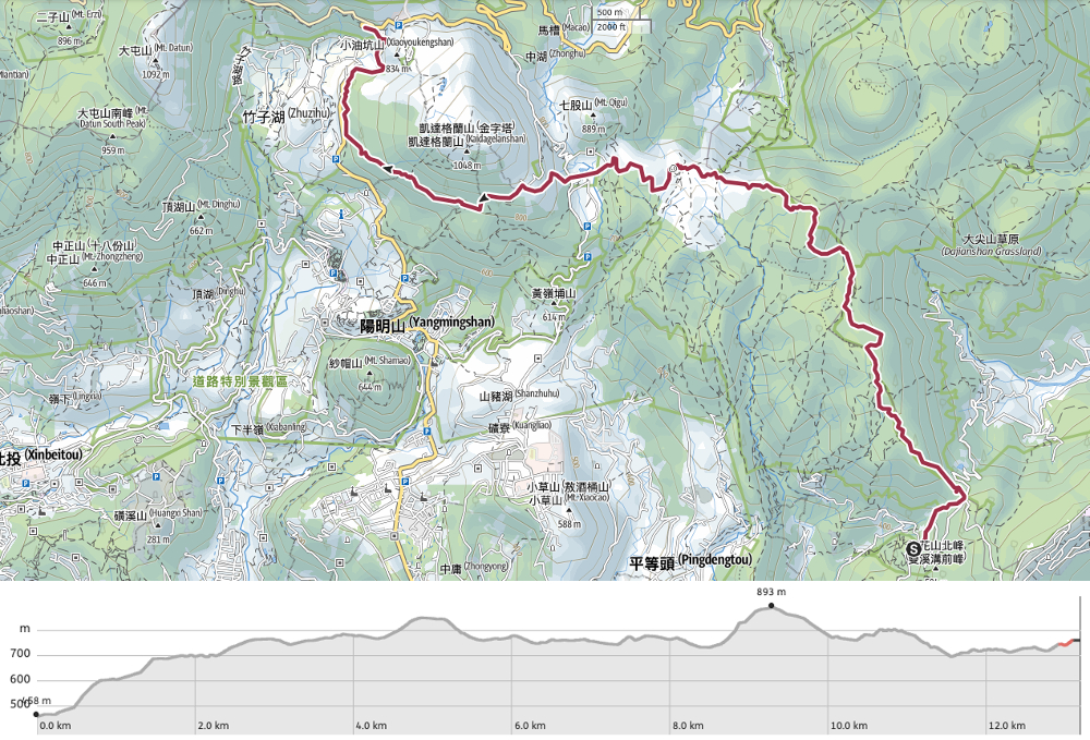
DISTANCE: 13.2km – a little more if you take the alternate route over Qixing Shan.
TIME: 5½-7 hours – it took me close to 6½ hours but that was because I wasted time going the wrong way. 5½ hours wouldn’t include any long breaks unless you’re particularly speedy, and if you plan to scale Qixing Shan then budget extra time.
TOTAL ASCENT: Around 700 metres – but again, climbing Qixing Shan would increase this figure.
DIFFICULTY (REGULAR TAIWAN HIKERS): 3/10 – the only difficulty here comes from the distance covered, elevation gain, and a small section of rough trail. Combining this with the next section (all the way down to Guandu MRT station) takes this up to a 4/10, purely because of the mental stamina required to make your tired feet keep carrying you that far.
DIFFICULTY (NEW HIKERS): 5/10 – I remember finding just one of these peaks quite tiring earlier on in my hiking career, but it’s a pretty easy medium-long distance trail to practise increasing your mileage and stamina, especially since there are plenty of places where you can drop out if you’re too tired.
SIGNAGE: There’s next to no Taipei Skyline Trail signage along this section (although you may spot a sticker or two added onto fingerposts here and there), but all of the major trails are clearly marked in both English and Chinese.
FOOD AND WATER: 1L should be enough to get you as far as Qingtiangang Visitor Centre (with spare), where you can stock up either by filling a reusable bottle inside the visitor centre or you could buy bottled water/sports drinks. There is a second pitstop at Lengshuikeng where refreshments are available (a water dispenser, bottles and a few hot drinks). In both places the snack selection is basic, a few dry biscuit-type things, energy bars, dried tofu (Lengshuikeng has a few cake offerings too), so if you’re particular about your hiking food then you’d be better off preparing snacks. I took fruit, nuts, a can of congee and salt candy.
SHADE: Long stretches of this walk are entirely unshaded, and the most exposed are often particularly windy. If you are sensitive to the sun, choose your sun protection wisely. Hats need to have a strap to keep them on your head and umbrellas should be sturdy.
MOBILE NETWORK: Generally ok with black spots here and there. I wasn’t aware of being without coverage for more than 15 minutes at a time.
ENJOYMENT: This is a perfect trail to take you on a walking tour of some of Yangmingshan’s more popular highlights.
SOLO HIKE-ABILITY: The only section you might not be comfortable hiking alone is the short (25-minute) stretch between Lengmiao Trail and Jinlutian Temple. If you don’t fancy this then you can always detour over Qixing Shan.
OTHER: I always take a stick when hiking in Yangmingshan National Park these days, partly to help with all of the steep downward steps, but also because many of the trails are very slippery and having an extra point of contact helps with balance.
ROUTE TYPE: Point to point.
PERMIT: None needed.
TRAILS AND POINTS OF INTEREST ALONG THE WAY:
- Fengguizui (風櫃嘴)
- Dingshan (頂山)
- Japanese Cedar Forest (柳杉造林地)
- Jinbaoli Gate (金包里大路城門)
- Qingtiangang Visitor Centre (擎天崗服務站)
- Yonglai Mine Ruins (雍來礦場跡地)
- Milk Pond (牛奶湖)
- Lengshuikeng Visitor Centre (冷水坑服務站)
- Qixing Park (七星公園)
OPTIONS TO SPLIT/COMBINE THIS ROUTE:
- To make the journey shorter it would be possible to stop earlier, either at Qingtiangang or Lengshuikeng, both of which are served by public transport (see below for details).
- Alternatively, if you prefer your walks to be long and punishing, or if you’re in training for something tougher, then you could always combine this section with the second half of section six and walk all the way to Guandu.
Jump to the bottom of this post for a trail map and GPX file.
DIRECTIONS:
Numbers by photos refer to the GPS coordinates at the end of the post.
For the first time in over a year, I found myself on the early bus up to Fengguizui bus stop, and was charmed by the friendliness of the driver. The bus leaves the city before 6:30am to crawl its way up and around the mountain roads, and it seemed as if the bus driver was familiar with all of the early morning walkers and joggers, each one got a cheery wave and a nod of the head.

06:41 – Over half of the passengers alighted at the Fengguizui stop, more than on any previous visit – perhaps the good weather had enticed out a few extra walkers. From the bus stop, you need to walk uphill a short way before you’re able to get on the trail.

06:48 – As the road takes a sharp bend to the right, make straight for the steps leading into the treeline. This 300m-long strip of path is Fengguizui Trail (風櫃嘴步道), and is actually just a shortcut, so if you feel like warming up your muscles you could always take the longer, gentler route up the road (the distance is at least tripled though, so most people take the steps).

I ended up crossing paths with the chap with the blue shirt and bright orange rucksack multiple times until eventually arriving at Qingtian Temple at the same time as him and his hiking buddy, (they dropped out at that point but I had a little further left to go).
Halfway up the steps I was rewarded with my first cool insect sighting of the day: a skinny little wandering hammerhead worm (笄渦蟲 in Chinese). It took me almost five years of hiking in Taiwan to spot one of these fascinating carnivorous worms, and then finally this year I’ve seen two of them.

06:58 – At the top of the steps the trail rejoins the road right next to Fengguizui Pavilion. This is the start of the walk proper, so it’s a good idea to take a couple of minutes to make sure you’ve got your pack all set up comfortably and are ready to go. There were quite a few people and cars around even at 7am on a Monday morning, but if you visit on weekends this area is packed with cyclists and hikers from dawn to dusk. When you’re ready to set off, take the steps which head up to the right of the pavilion. (1)
(That marker post between the pavilion and the fingerpost is one of the pillars that you need to take a selfie with if you are trying to complete the Taipei Grand Hike challenge.)

It was clear even from the start that it was shaping up to be a glorious day, sunny, but with the tiniest bite of autumn cool reassuring me that it wouldn’t be unbearably hot later on.

Although I have walked this way a number of times, this was the first time that I had spotted a little side trail here not far from the trailhead. This early in the day, I still had oodles of excess energy, and after noticing on the map that it was a very brief diversion, I decided to go and take a look.

07:05 – A minute later I found myself in a small and hemmed-in clearing with a triangulation stone and a marker to tell me that I was on top of Xiangdui Shan (香對山). I guess that during 2020 and 2021’s travel restrictions people have gone somewhat stir crazy in Taiwan trying to find new heights to scale, new peaks to conquer – that might explain why this trail has suddenly become more defined.

There was no point in hanging around at Xiangdui Shan, so I returned to the main trail and soon found myself going through the cattle gate which marks the entrance into the area grazed by Yangmingshan’s wild herd of water buffalo. For much of 2019 and 2020 the cattle were confined to the small area of grassland around Qingtiangang after a number of ‘attacks’ on tourists. Park management spent the time installing cattle bollards at various points around the park along with information boards on how to avoid provoking them. Now they’re free to roam once more so you might encounter them, but it’s no cause for concern, in general, they are very docile beasts, just let them do their thing and you should be fine.

At this point in the walk all of the best views are behind you, so it pays to stop and turn around take a look every now and then. It’s a little hard to make it out in the haze, but Keelung Islet is just about visible on the horizon.

For the first few kilometres the trail dips in and out of the tree coverage – there are a number of minor trails which join from the left along this section, but most of them are marked with signage which deters straying from the main trail, so it’s very easy to know where you’re meant to be going.

07:44 – The second peak of the day (although just the first according to the actual trail) was 768m high Ding Shan. From here you also get your first view of where your’e headed – Qixing Shan (or you can if the weather is clear).

On the right of the path you can see some of the cattle bollards that have been added in recent years. The presence of patchy grassland is at least in part due to the grazing of cattle, although they tend to prefer hanging out in spots with both grass and water present. That being said, you don’t get to see much water on this trail (but some of the prettiest walks in all of Yangmingshan National Park follow water courses on the lower southern slopes of this ridge). In fact, the ridge that the trail follows from Fengguizui up and over Ding Shan and beyond is the dividing line between two watersheds, on the north, all the water flows down into Malian Stream, and eventually the ocean, whilst all streams on the south converge on Neishuang Stream which then joins Keelung River.
07:55 – About an hour after beginning my walk I found myself passing through a spot which is labelled on the map as being the Japanese cedar forest. I was lucky to catch it when the sun was still low in the sky – just look at the light picking out the outlines of those tree trunks in gold!
As with other places that you’re likely to see these trees, here they are indicative of historic afforestation attempts. Although the indigenous Ketagalan people of Taiwan had been hunting and foraging in the forests on these hills for (potentially) millennia, from the 1600s onwards waves of settlers began to exploit the region’s natural resources. The area provided camphor, wood for charcoal and flat farmland for growing crops like millet and sweet potato. Later on more land was used for growing tea and indigo, osmanthus and bamboo, then later again citrus fruits. By the time the Japanese Crown Prince paid a visit to his country’s ‘model’ colony (in 1924), much of the area we now know as Yangmingshan National Park was bald, and as a result, it was decided that reforestation efforts should be made. Unfortunately, the government at the time didn’t know as much about conservation, many of the species that they used to replant the woods were ill-suited to the climate, and consequently the recovery was patchy.

Breaking out on the far side of the cedar forest you can catch a glimpse of one of the meadows a little further along the trail. The first time I visited I remember seeing cattle grazing here, but for the past two years I haven’t spotted them anyway beyond Qingtiangang.

When I arrived at the meadow in the above picture I turned back to look east in the direction I’d come from and noticed this lone hiker taking a break on top of North Wuzhi Shan (北五指山) – one day I will have to come back and visit more of these grassy peaks.

Looking back towards where I’d just come from I saw a couple of my bus-mates coming up the hill. By this point in the journey, the wind was really starting to pick up quite a bit and I had to tighten the strap on my hat.

Then as I climbed a little further up the hill I could see Taipei 101 standing out from the haze – on clearer days you can see hills for miles and miles.

08:30 – After an hour and a half of walking I arrived at the high point of Shiti Ridge.
The views from up here are utterly spectacular, you can turn in a full circle and see peaks, sea and city. (I’d keep the sound off unless you’re a big fan of wind noises.)

08:48 – Fencing on the right marks the entrance to Huangzui Crater Trail – yet another place I’ve had on my list of places to explore for a very long time.

As the trail makes its final descent into Qingtiangang grassland there are some beautiful views over towards Qixing Shan – its knobbly-topped seven peaks clear to see in the sunny weather.

With binoculars or a telephoto lens you can see the smooth dome of Shaomao Shan rising from beyond the new fenced-in Qingtiangang Trail (built to try and keep the wandering masses safely separate from grazing cattle). There are normally a few water buffalo to be seen in this area, and in the foreground, one of the bunkers which are remnants left over from the area’s most recent defensive role. During the econd Sino-Japanese war, Japanese forces built fortifications on top of the flat grassland here to prevent it from being used as a landing point for enemy forces, and they were later co-opted by the Kuomintang troops as part of a controlled military area and training space.

Keep following the main trail through over undulating hills and on towards Qingtiangang Visitor Centre.

09:06 – Shortly before you arrive at the carpark you’ll pass Jinbaoli Gate on your right. It sits at the entrance to the old Fish Road or Jinbaoli Trail, and like the bunkers, this is another relic of Taiwan’s rather tumultuous past – in this case it is a modern marker of the defenses built by Jian Da-shi (簡大獅) and his volunteer army of anti-Japanese resistance fighters at the close of the nineteenth century. Jian’s army capitulated after a few short years, and he later went on to play a part in managing the Japanese Road – a trail which stretches from this point down to Shilin on one side and Jinshan on the other, often crossing over the older Fish Road.

The gentle trail from the visitor centre to the old cattle shelter (now home to a few information boards), is always popular with people looking for an easy way to enjoy the outdoors. Don’t take this trail, instead keep going towards the visitor centre.

Sitting adjacent to the visitor centre is Lingtou Rock Land God Temple (領頭喦土地公廟), and right behind it is a smaller, older temple. The older one was carried here over 200 years ago from the base of nearby Mount Zhuzi. Given its location on the old Fish Road, this temple would have been an important marker for those travelling in from the coast to sell their wares in the city.

09:17 – Follow the steps leading down to the visitor centre car park and then take the road which winds away towards Lengshuikeng. There are toilets here, as well as a bus stop, a small store and a visitor centre with some information about the area. Inside the visitor centre, there’s a water dispenser where you can fill up your bottle – although it was out of use due to pandemic restrictions on my most recent visit. (2)

Such is the prettiness of Yangmingshan National Park, that even walking along the side of the road rewards you with beautiful views.

Another charming view of Qixing Shan – note the two red and white radio masts to the left of the peaks, this is the highest point on this particular section of the TSLT (unless you’re planning to go up and over Qixing Shan).

09:35 – To the right of the road keep an eye out for the remains of Yonglai Mine. You might not guess it to look at the site now, but this area had been mined for a long time – first extracting blocks of sulphur (a key component of gunpowder) , then iron sulphide ore (for use as a fertiliser), and in the final decades chalky clay (used in chemical manufacturing). Mining operations came to an end in 1993 and the site has since been left to the elements. (3)

Keep following the road until you spot a pavilion on the left then head left onto a wide trail.

09:41 – The path climbs down a short way before arriving at Jingshan suspension bridge (菁山吊橋). This spot is a firm favourite with wedding photographers and Instagrammers alike, and as such you’ll be very lucky to get the bridge to yourself – even on a weekday or in gloomy weather. Head straight over the bridge here and on towards the visitor centre.

If you haven’t visited this corner of Yangmingshan before then it’s worth taking the tiny detour on the right here to take a look at the Milk Pond (also known as the Niunai Pond/牛奶湖).

The pool was once an open-cast sulphur mine operated by Ruiyong Mining Company, but after operations shut down the pit was left to accumulate rainwater. The milky appearance of the pool is also attributable to the land’s mineral deposits – the whiteness is caused by tiny particles of sulphur that are suspended in the water.

09:48 – Lengshuikeng Visitor Centre is a good place to take a break, use the toilets and stock up on water since it’s the last place on the trail with all these facilities. I had planned to fill up my water bottles from the dispenser inside the information centre, but unfortunately, it was out of action. Somewhat grumpily I resorted to buying a bottle of water as well as a coffee (how it’s ok for the cafe staff to use my own cup for coffee, but not ok for me to fill a water bottle is beyond me – Taiwan national parks, please do better in setting an example of environmental best practice). And a piece of cake – cake is good, solid hiking fuel and being able to buy it part way along a trail reminds me of hiking back home in the UK. (4)

10:18 – I must have stopped for almost half an hour, and when I was ready to get going again I found the entrance to Qixing Shan Trail. There was a team of people working on fixing the railings, but the path remained open for business. Cross over the road and take the steps – prepare yourself for 20-30 minutes of climbing.

Ignore the left fork and keep heading straight on the main Qixing Shan Trail.

I was surprised to see that the silver grass was already in bloom in some areas of the park – it’s something I usually associate with the cooler months (November to February), but here it was in early October looking spectacular.

10:46 – The trail climbs to a summit of sorts at Menghuanhu Shan where there is a circular, two-storey pavilion. The pavilion has been taped off with signs condemning it as being unsafe since the last time I visited. I wonder if it will be fixed, pulled down or just left to slowly decay. Despite having just had cake, the climb sucked the energy out of me in the heat and I paused here for a few minutes.

At the next junction take a left turn towards the radio towers (if you haven’t been to Menghuan Lake before it’s just a brief detour along the road on the right).

10:56 – At the next junction you have a choice to make. Either head left and take a less up and down, but slightly more rough route, or turn right and climb up and over Qixing Shan. I have climbed Mount Qixing numerous times now, but I’d never taken the trail on the left, so I decided to opt for the unknown and went left towards Qixing Park. If you fancy a little more of a climb then you can take a look at my post on the Taipei Grand Hike Day 3 since that covers almost exactly the same ground as this trail.

In a very short time I found myself coming across the first pavilion in Qixing Park. Here you can either follow the trail left around the lip of the park or right and stick close to the tree line. As long as you exit the park via the trail next to the toilet block you’ll be going the right way.

A couple standing on a fake tree trunk picnic table to point out spots in the city and distant mountains. (5)

The pavilions here look to be quite old, although still in pretty good shape. Plenty of people were sitting under their shade to have a spot of lunch whilst enjoying the view. Although it is very definitely not a wild space, I found Qixing Park to be really quite pleasant and can understand why people might want to come here just to enjoy relaxing in this outdoor space away from the city’s heat.

Heading past the toilet block take the paved trail into the woods over on the western edge of the park.

The ugly concrete soon gives way to a more pleasant looking stone trail, although I imagine it’s rather slippery in wet weather.

11:08 – At the pavilion take a left turn and follow steps down to join up with Lengmiao Trail (so named because it connects Lengshuikeng with Miaopu).

11:10 – Very quickly there is another junction, here keep right and start heading down towards the Miaopu side trail head.
Just a few metres away from the previous junction I had a very lucky encounter with this Hatori’s coral snake. Lucky both because I was able to stop another guy from treading on it, and lucky because it’s a pretty uncommon snake to spot, and even more uncommon in daylight hours. These snakes are endemic to Taiwan, highly venomous and are a category two protected species. It thrashed around a bit after almost being trodden on, but as soon as it decided we weren’t a threat it slipped away more calmly.

This is the hiker who almost trod on the snake. Lengmiao Trail was an unexpectedly pleasant part of the journey, it’s a prettily shaded path, and after the exposed sun of Shiti Ridge I was grateful for the tree cover.

12:10* – If you’re an observant reader you may have noticed the asterisk next to the time on this one. That is because I was a silly fool and didn’t check that I was on the right course for almost half an hour – then upon checking I realised that approximately half an hour earlier I had strayed from the correct course. In fact, this junction is probably just a few minutes away from the previous junction, but instead, I walked all the way down to the Miaopu trailhead and then had to retrace my steps. Keep a careful eye open for the trail marker on the right which indicates that you’re 1km away from Miaopu trailhead. Here the trail takes a sharp right turn onto an unpaved path through the forest, it’s very easily missed so you need to be looking for it. (6)

This short stretch is the least maintained part along the whole of the TSLT section six and I assume that most people decide to head up and over Mount Qixing instead. I thought this made a pleasant change though, and was glad to have strayed a little from trails that I had previously explored.

12:35 – The path opens out onto a clearing in front of Jinlutian Temple (金露天宮), and a couple of temple dogs started barking noisily at my presence. Someone soon came out to shush them and I carried on with my journey. From here take the track which runs down to join the main road. (7)

12:51 – Just before the track reaches the road it crosses over the Qixing Shan Round Mountain Trail, turn right onto the trail and follow it through the woods parallel to the raod.

Thanks to its position on the western slope of Mount Qixing, this section of the round mountain trail is EXTREMELY slippery. You need to take great care where you’re placing your feet if you want to avoid making a fool of yourself.

13:07 – Ignore the first turn-off on the left and keep walking on the round mountain trail until the steps lead you out onto the road. At some point along the way, I became aware of the rotten egg smell of sulphur in the air, a sign that I was drawing closer to the massive crater of Xiaoyoukeng. When you hit the road cross over, bearing right and take the trail immediately behind the red and white barriers. (It was closed for construction work when I visited, so I had to follow the road instead.)

13:12 – The trail crosses under the road just before Xiaoyoukeng Bridge, then crosses a creek and heads under the bridge once more.

As you cross the creek take a glance to your right to have a look at the dramatic, steaming sight of Xiaoyoukeng fumarole. On a bright sunny day the effect isn’t quite so impressive, but on a grey and cloudy day its intense.

Keep following the road mountain trail from Xiaoyoukeng bridge – the path crosses a small tributary of Yangming Stream. At the far side of the stream keep heading straight (a left turn would take you down to Zhuzihu).

13:24 – After a short while the trail climbs to rejoin the road. Follow it to the left for a while until you arrive at Bailaka Road Intersection bus stop. From here you have to decide whether to push on a bit further (another three and a bit hours at a minimum if you go as far as Qingtian Temple, or in my case another five hours), or to hop on a bus back to the city. (8)
GETTING THERE
Google Maps address: This section of the TSLT starts from Fengguizui bus stop and finishes at Bailaka Road Intersection. There are a few parking spaces at each spot, but public transport is a lot more convenient given that this is an A-B type route.
GPS location:
- Fengguizui lookout trail head – N25 08.220 E121 36.170
- Qingtiangang Visitor Centre – N25 10.020 E121 34.470
- Yonglai Mine Ruins – N25 10.060 E121 34.060
- Lengshuikeng Visitor Centre – N25 9.965 E121 33.835
- Qixing Park – N25 09.850 E121 33.400
- Turn off from Lengmiao Trail – N25 09.820 E121 33.150
- Jinlutian Temple – N25 10.000 E121 32.830
- Bailaka Road Intersection bus stop – N25 10.780 E121 32.570
Public transport:
- The M1 (市民小巴1) service will get you to Feng Gui Zui, it is a scheduled bus service, and it leaves from Jiantan MRT Station. There are just a handful of buses each day, and on weekends you have to arrive at the first stop a good 2-30 minutes early to be sure of a seat.
- If you plan to split the trail at Qingtiangang, you can take either the 108 back to Yangmingshan Park bus stop, or the S15 to Jiantan MRT Station.
- If you plan to split the trail at Lengshuikeng, you can take the S15 to Jiantan MRT Station – make sure you get the one heading back to Jiantan as
- From Bailaka Road Intersection from the Zhuzihu side of the road you can either catch the 1717, (this heads back to Taipei Main Train Station via Jiantan), or the 108 back to Yangmingshan Park bus stop from where you can catch buses to wherever.
Further reading: There isn’t any other English info on walking this (in relation to the TSLT) as of yet, but this post covers a similar trail only heading in the other direction, it also only goes as far as Xiaoyoukeng, the rest of the journey is covered in his next installment.
Nearby trails: I’ve done numerous walks in the area, many of which could be included in any number of combinations to form alternate routes to parts of this longer journey.
- Neishuang Creek Trail
- Deng Feng Canal Trail
- Taipei Grand Hike Sections three and four
- Qingtiangang Circular Trail
- Juansi Waterfall
- Mount Qixing Trail
- Mount Qixing Round Mountain Trail
TAIPEI SKYLINE TRAIL SECTION 6A – TRAIL MAP
GPX file available here on Outdoor Active.
This is the bit where I come to you cap in hand. If you’ve got all the way down this page, then I can only assume that you’re actually interested in the stuff I write about. If this is the case and you feel inclined to chip in a few dollars for transport and time then I would appreciate it immensely. You can find me on either Ko-fi or Buy Me a Coffee.
