
Xindian to Caonan
(台北天際線1A段:新店/貓空/草湳)
Climbing from the cerulean waters of Xindian River, this section of the Taipei Skyline Trail takes you up to the ridge line that runs from Bitan over towards Shiding, getting steadily more rugged as it makes its way further east. People tougher than me might want to attempt both section 1A and 1B together, but you’d either have to be a trail runner or set aside a good 12 hours to complete the whole lot.
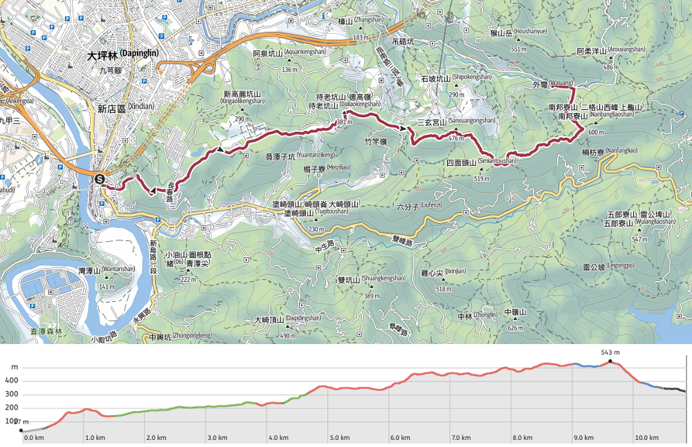
DISTANCE: 10.9km
TIME: 5½ hours at a pretty gentle pace and plenty of breaks to stop and look at things that interested me.
TOTAL ASCENT: A little over 600 metres.
DIFFICULTY (REGULAR TAIWAN HIKERS): 4-5/10 – On a hot day, this was tiring. On a cooler day I’m sure it wouldn’t have felt so hard. Quite a lot of climbing to do, and some steep, roped sections.
DIFFICULTY (NEW HIKERS): 5-7/10 – If you’re fit, it should be doable, but if you’re not familiar with the area, then you will at least need to be good at reading maps because the trail feels a little bit all over the place. Quite steep and there are some slightly overgrown areas.
SIGNAGE: The signage is ok in places, less ok in others. Most junctions have a little TSLT sign, but not all. Signage is only in English in the more popular areas.
FOOD AND WATER: I drank about 1.8L on a hot day in May. For food I just took, nuts, salt candy and some tinned congee, but you can always take a diversion to sample the snacks at Maokong.
SHADE: Long stretches with little shade. I used my umbrella quite a bit.
MOBILE NETWORK: The latter section between Maokong and Caonan was almost entirely a mobile dead zone.
ENJOYMENT: This section of the TSLT has some lovely views close to Xindian, and I was chuffed to finally link up trails that I’d only done separately before. Previously I’d only ever walked from Xindian to Maokong, and then the trails around Caonan to Shiding, never the part between them.
SOLO HIKE-ABILITY: The trail from Xindian to Maokong is a pretty safe bet for solo hikers. The trails aren’t dangerous and the signage is relatively clear. The final stretch between Maokong and Caonan might feel a bit quiet if you’re not used to solo hiking, but as long as you’re confident reading maps, then you should be fine.
OTHER: A hiking pole would be helpful. I put my gloves on for a short way, but I’m not sure they’re entirely necessary.
ROUTE TYPE: Point to point.
PERMIT: None needed.
TRAILS AND POINTS OF INTEREST ALONG THE WAY:
- Xindian Lion‘s Head Hiking Trail (小獅山登山步道)
- U-Theatre’s Outdoor Venue (優人神鼓山上劇場)
- Daliaokeng Shan (待老坑山)
- Ejiaoge Shan (鵝角格山)
- Maokong Peak (貓空尖山)
- Caonan Great Banyan (草湳大榕樹)
OPTIONS TO SPLIT THIS ROUTE:
- Xindian to Maokong Gondola – This would still be a reasonably long walk
- Maokong Gondola to Caonan – If you only go as far as Caonan, this might be a bit short.
- Maokong to Shiding – Breaking at Maokong would also be a good place to split section 11 in half.
Jump to the bottom of this post for a trail map and GPX file.
DIRECTIONS:
Numbers by photos refer to the GPS coordinates at the end of the post.

09:30 – This leg of the TSLT kicks off from Xindian, the southern terminus of the green line. Turn right out of the turnstiles, and onto Beiyi Road.


Turning right onto Beiyi Road, head straight for the twin 7-Elevens (the pavement was blocked by this waving construction dummy). When you draw almost level to the second 7-Eleven turn left onto Wenzhhong Road.


09:36 – Keep walking straight up, cross over Nengren Road and follow the single-lane road up to Zhulin Chan Temple. When you get to the temple, you’ll find that the road runs out and you need to take the steps on the left (they’re part blocked by an inconveniently placed pole). (1)

Soon I found myself enjoying the first view of the day. A little overlook lets you see the city spreading out in front of the hills around Nansijiao Shan.

A little further up on the left, I was surprised to spot the first Yingge Rock of this journey (the second one being on the trail just above the town of Yingge). Unlike its more famous counterpart, there seems to be scant information out there as to where this one got its name. (I guess it probably just looks like a bird.)


09:51 – The trail climbs to Cihui Pavilion (慈惠亭), take a right here and walk through the shelter of the pavilion. (The Lion’s Head Hill that this hiking area is named after is a little ways away to the left.) A happy-looking gent sat in the shade, fanning himself and listening to music on his phone. As I passed through he gestured at the teapot, urging me to stay a while and drink, but with so far to go, I demurred, it was too early to take a break.


Just a little way beyond Cihui Pavilion, the trail splits in two once more. Take the path on the right leading uphill. Here you can also enjoy the view looking over the hills to the south of Xindian. That long, flat-topped one to the left is another, more adventurous Lion’s Head Mountain, the one that straddles the border of Xindian and Sanxia Districts.

The trail climbs–if not steeply, then unrelentingly–past another pavilion and exercise area, and ever upwards until…

…until arriving at the three-level Changshou Pavilion (長壽亭) on top of Wen Shan (文山).

10:04 – It really is worth climbing the spiral stairs to the top floor, because the vantage point offers you some of the most spectacular views of the whole walk. In one direction you can see Taipei 101 standing proud above the tightly packed, busy city, and in the other, it’s nothing but blue skies, bluer waters, and the enticing peaks of Wulai District.

Leaving the view behind. I continued down the far side, passing through Mingde Pavilion (明德亭).

There is a slightly different view to be enjoyed here, you can see the bend in the Xindian River where the trail from Mount Hemei comes down and you need to pay the ferryman to take you back across the water.

Steps lead down from Mingde Pavilion, taking you through a grassy area and on towards allotments. (Don’t take that side trail on the right, just keep heading straight.)


10:21 – (2) When the trail reaches the road, cross straight over and head up past a bus stop along Lane 19, then at the top end turn left onto Zhangchun Road.


Actually, the next long stretch all follows Zhangchun Road, but there are quite a lot of junctions. Follow it as it curves to the right, then at the next fork, stick with Zhangchun Road, again on the right.


Towards the end of this little community, take the lefthand fork (straight on is a dead end anyway). Beyond this, there is a long stretch of road walking with very few junctions to distract you.

At one point I found myself passing a whole row of all-but-abandoned houses. Just one or two properties on the edges of the terraces seemed to be occupied, the rest have been left to slowly crumble.

10:44 – Follow Zhangchun Road as far as this junction, then cross straight over. (There is a hiking trail visible on the right here, but that is not where this walk takes you.) As I was about to cross, a police car passed me, turned into the road on the right and watched me walk by. When I crossed over, they pulled away, looping back and driving ahead of me once more.

10:44 – As I passed a land god temple, the police car returned, passing me for the third time in two minutes, and pulled in directly opposite me. I was starting to feel a little uneasy by this point, but who knows, maybe they were just looking for somewhere to take a leak.


I kept following the road as it passes through areas of allotments and scruffy company bases. Thankfully the police never caught up with me again.

10:55 – The road terminates at a wide unmarked parking area, and Mount Dailaokeng Trail cuts down into the trees beyond. (3)

Algae-clad steps head down to a junction. Pass straight over and start climbing again, passing a diminutive trailside Tudi Gong shrine.

Just next to the shrine, something on a tree trunk caught my attention. This amazingly fragile-looking cocoon around a pupating lichen moth. I had no idea that such creatures existed, but evidently the moths in this genus fashion basket cocoons out of the hairs that cloaked their bodies during the caterpillar phase. After I spotted this first one, I saw several others on nearby trees, and I can testify that despite looking flimsy, these structures are pretty strong, I blew on some to see if they’d move, but while the nearby moss was swayed, the cocoons didn’t budge, not even a little.

After the path reaches a high point, it bends to the right then starts to descend through a young-looking bamboo farm.


11:14 – Keep following the path past a place which certainly was a cafe at some point. (It might still be on weekends I guess, but it looks a bit abandoned.) It almost feels as if there’s no way out onto the road here, but just keep going to the far end of the building and all the way to the gate. The way out will finally reveal itself. Once on the other side of the gate, turn left onto the road and walk towards a raised temple.


The temple is painted a sleek white and red combination and has a cutely fierce Huye guarding it. (As well as a couple of dozy feral dogs.) Immediately beyond the temple, take the track leading up and away from the road on the right.

The first little stretch runs through a betel nut plantation, then through forest. Partway up, I interrupted this pair of bamboo partridges enjoying a midday dust bath.

11:27 – Stay on the track until you see these steps branching off on the left. Soon you’ll pass the lantern-decorated gate marking the entrance to the legendarily hardcore U-Theatre’s outdoor performance venue (優人神鼓). I saw them perform once while I was still living in Hong Kong, but have yet to see them at work on home soil. The group is famed for its intense training regime, with performers living a very pared-back life full of rehearsals, tai-chi and long, pilgrimage-style journeys across Taiwan.


Two more side trails join/split off on the right, ignore them and just keep following the main path as it climbs (relentlessly) upwards. I started to struggle in the heat and had to take breaks to cool down.

At the top of the steps, the TSLT continues to the right, but first…

11:43 – Take a quick detour to visit the summit of Mount Dailaokeng (待老坑山).

I also had a brief rest before setting off on the trail marked as going towards both Yinhe Cave Waterfall, and Zhanghu Trail.


There are numerous side trails leading off in all directions, but ignore them all for now and continue along the ridge.

Take the trail on the right here leading up and onwards in the direction of Maokong.


The trail is gently pretty, but not all that pleasant to walk on – slippery wood and gravel don’t go nicely together. That red hut on the right there is a basic little land god temple. Head straight over once more at this crossroads. (Left would lead down to join section seven of the Taipei Grand Hike close to the Maokong Gondola, while the one on the right tracks down to Yinhe Cave.)

12:03 – Another hundred metres or so from the last junction it’s time to finally stray from the paved trail. Take the dirt path on the right leading up into the trees.

This is narrower and less frequently traversed than the trails I had been following so far. It felt good to get my boots onto soft ground at last.
A real bonus of this section was looking down to spot this tiny little bean perched on a fern. It was the smallest tree frog I have ever seen – an absolute cutie. Hopefully, it will live long enough to learn to camouflage itself a little better.

12:25 – The trail climbs steeply on the way to Ejiaoge Shan (鵝角格山), and once at the top, I took a ten-minute break and ate a little to replace lost energy.


The trail along the ridge line is surprisingly lush and leafy, flanked with all sorts of fern life. From Ejiaoge Shan, the path first runs along the top of the mountain to another triangulation marker, before starting to head down again. Eventually it tracks down to a clearing where steps coming up from Maokong join the path heading straight through and over in the direction of Maokong Peak. The TSLT goes straight over and up here, but…

12:45 – I got waylaid by the offer of a homemade ice lolly (made of taro puree with red beans and sweetcorn for added texture) from the couple to the left of this photo. Normally I will avoid anything red bean flavoured, that and matcha are two things I just can’t quite bring myself to like, but somehow the unsweetened, homemade version was far more palatable – perhaps the oppressive heat had something to do with how eagerly I consumed it too. Feeling suitably refreshed, I continued on and up the steps.

Just a short way up from the clearing there is another divergence of trails. Take the less-defined one on the right. (The lefthand path only goes a little further before arriving at a lookout spot and Sanxuangong Shan.)

This marks the start of the quieter, greener, and slightly wilder portion of the journey. Epiphytic plants cloaked every available branch and the air hummed with the song of cicadas and barbets.

There are also quite a few more trails branching off all over the place, not all of them signposted. At this one, only the one on the right appeared on my map even.


Soon there are a couple of trails on the left leading up to Shiliufen Shan, ignore them and keep to the flat trail (unless you want to do a detour to the peak, it wouldn’t really add much time).


13:20 – Soon I found myself at a bigger junction, with a stone bench, beautiful hand-drawn map and a wonky, illegible fingerpost. Take the lefthand trail towards Maokong Peak. After another couple of minutes, you should find the trail that cut up and over Shuliufen Shan rejoining on the left.

The trail actually heads straight over here, but there’s a slippery patch of rock so walkers have created a short detour. (There is also a faint trail heading away to the right, so make sure not to take that one.)

13:27 – The next junction arrives on a bend. Take the trail on the left leading off the path you’re on.


The path climbs towards an area of bamboo farm that is clearly still being looked after. As a drew close to what was by far the creepiest spot on the whole walk (a dark-windowed farmer’s shelter deep in the hills), a muntjac with an evil sense of humour chose that precise moment to start barking up a storm.

The path heads out the back end of the farmland then starts to climb up steeply.

After climbing for a few minutes, I found myself at a junction. As you walk it, the trail takes a sharp right. But in this picture it’s the trail heading straight away from where I was standing. You might not even notice that this is a junction though since the other trail is barely visible.


This stretch was definitely the quietest and most remote feeling of the day’s walking.

13:45 – Maokong Peak (貓空尖) has a tiny clearing, big enough to accommodate a few people standing, and a bit of a view–although not a particularly impressive one. I didn’t stop long, and made my way down from the far side of the clearing.

A gap in the trees afforded me my first view of the relay station between Maokong Peak and Erge Shan.


13:59 – Then almost before I knew it, the trail spat me out onto a track just below the relay station. Follow the track to the right, around the station and then continue along the ridge on the far side. (Actually, I think you can walk either way around the station.)

14:09 – The track takes you all the way down as far as this Fude Temple. It seems like the perfect spot to take a break, there’s shade from the temple’s sprawling companion tree, and a gentle breeze blowing across the clearing.

There are three or four trails leading away from the temple, but the trail you want is the one heading up from the righthand rear corner of the temple, beside this brick structure. There are TSLT markers here though, so it’s easy enough to work out. From this point, there is another steep climb, and I will freely admit that more climbing is entirely not what I wanted at this point.

14:23 0 Thankfully though, the climb is short-lived, and I soon found myself at the junction that would be where I left the TSLT for this leg of the journey. To head to Caonan (and a bus home), take the trail on the left here, but if you have excess energy, the TSLT continues straight on.

Honestly, it’s worth heading down this way if only because you are treated to this utterly spectacular sight. Ferns are practically dripping off of every branch, and the whole place glows green. When you cross a small stream and pass through these tall stands of bamboo you’ll know that you’re almost down to the track.

14:48 – (5) The path heads down to join a track. Turn right onto the track and follow the stream as it flows downhill. But before you do…


…if your shoes are a little muddy, local hikers have stashed a boot-washing kit by the track just a couple of metres upstream from where the trail joins it. I took a couple of minutes to scrub the worst of the mud off before continuing on my way.


14:48 – Keep close to the stream, and stick with it when it turns left at the end of the road. There is a bus stop here, but the service is infrequent, so it’s a much safer bet to just turn left and walk down Zhinan Road until you reach the next one.

15:05 – At the junction turn left and take a seat at the bus stop to wait for your ride back. (There are toilets here too in case you fancy a bit of a wash before squeezing yourself in amongst all of the other passengers.)
GETTING THERE
Google Maps address: This section of the TSLT starts at Xindian, and ends at Caonan bridge.
GPS location:
- Trailhead beside Zhulin Chan Temple – N24 57.390 E121 32.490
- Trailhead exiting onto Zhangchun Road – N24 57.365 E121 32.900
- Trailhead at the start of Mount Dailaokeng Trail – N24 57.830 E121 33.960
- Trailhead next to U-Theatre performance space – N24 57.910 E121 34.380
- Caonan Banyan trailhead – N24 58.060 E121 36.480
Public transport:
- The starting point is easy, just hop on the green line and ride it all the way to Xindian MRT Station.
- From Caonan there are several buses you can catch. The BR15 and Maokong Left (look for 貓空左線 on the scrolling signboard the English translation was I think just the pinyin, but I might be wrong) are probably your best bet since they both go down to Taipei Zoo MRT Station, and from there you can take the brown line back to town. The S10 also takes you in roughly the same direction, but it goes to Wanfang Community.
Nearby trails: I’ve done a whole lot of hiking in the area over the years.
- Bijia Ridge
- Dragon Trail to Maokong
- Erge Shan and Mount Nanbangliao
- Houshanyue
- Mount Hemei
- Taipei Grand Hike – Section 7
- Xindian Lion’s Head Mountain
- Yinhe Cave and Waterfall
TAIPEI SKYLINE TRAIL SECTION 1A – TRAIL MAP
GPX file available here on Outdoor Active. (Account needed, but the free one works just fine.)
If you enjoy what I write and would like to help me pay for the cost of running this site or train tickets to the next trailhead, then feel free to throw a few dollars my way. You can find me on PayPal, Buy Me a Coffee or Ko-fi, (and if you’re curious about the difference between the three you can check my about page).

Beautiful views!
LikeLike
This was very helpful, thank you! I had a great hike 🙂 just want to add that at the relay station, you do have to go to the right as you said in your post – going left takes you to a gate – but I would recommend going left first anyway for a good view over the city!
LikeLiked by 1 person
Thanks for the tip! I’m not sure how this comment slipped past me, but I’m glad you enjoyed your hike.
LikeLike