
Houshanyue Trail was one that lingered on my to-hike list for a few years. I never had any particular reason for not hiking it, I just never quite got round to it. Now I have, I can say that I’m very glad it didn’t get consigned to the to-hike list indefinitely. Houshanyue is a thoroughly satisfying half-day hike that will satisfy your need for adventure without spoiling your lie-in.
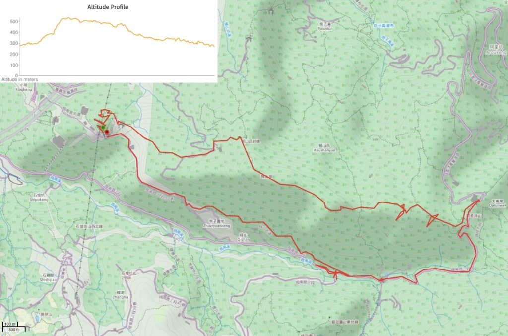
Distance: 9.7km
Time: 4¾ hours, but I was dawdling and I cooked when I didn’t particularly need to, so only 2½ hours were spent actually moving.
Difficulty (regular Taiwan hiker): 3/10 – There are a couple of steep sections and one or two spots where it’s not immediately clear where to go, but aside from that it’s pretty straightforward.
Difficulty (new Taiwan hiker): 5/10 – The climb from the start of the trail is steep, and the roped section will require a bit of care if you’re not used to it, but after that the path is mostly gentle in its ups and downs. Navigation should be ok as long as you have a map or route to follow.
Total ascent: About 450m.
Water: about 1.5L on my second visit on a warmer day, but on this cool day in the photos I don’t think I even finished a litre.
Shade: Pretty well-shaded, but I would still need a hat or umbrella in the summer.
Mobile network: Quite good. I think I only noticed I didn’t have any once or twice.
Enjoyment: It’s a cracking half-day hike if you want to experience something a little challenging but still want to have a bit of a lie-in. I always enjoy ridge hikes and this one didn’t let me down, there are occasional views (although not really when I went), some fun climbing that’s challenging but not too hard, and a nice stretch following along the ridge.
Other: I took gloves and a hiking stick and used both, (although I would have been ok without if the weather were drier. The gloves come in handy for grabbing onto the roots when you’re climbing and the stick for the slippery steps later on.
Permit: None needed
Jump to the bottom of this post for a trail map, GPX file, and transportation information.

I rode up in the gondola, and since I was queuing alone and didn’t mind which type of cabin I was in, I ended up being put in one of the glass-bottomed cabins all by myself. I’d never ridden in one of those before because I don’t particularly like heights, but it turns out that as long as I don’t have to walk or stand up, I feel fine.
After getting off at Zhinan Temple Station, I headed out towards the ornamental pond to start the walk. Actually there are two ways to get to Houshanyue Trail—the quickest is to head along the road under the temple arch and then turn left uphill.
I was still assessing the weather, and I’d never been to the little park above Zhinan Temple, so I took the trail heading up behind the gondola station.

The path zigzags its way up, snaking under the wires of the cable car. Decorations along the path seem to loosely conform to the 12 zodiac animals. There are a couple of junctions to navigate, but basically, stick to the left and upwards path. (I did a circuit of the outermost possible trail, so I took the left option at every junction until the start of the rougher mountain trail.)

After the steps climb up to the high point you will find these oversized jiaobei benches and a pavilion with views over the south-eastern tip of Taipei. They also seem to be trying to get the whole love-lock thing going up here, but it’s not as successful as the more accessible locations like near Raohe night market. Veer right-ish and if you pass some stone chickens and then dog statues you’ll know you’re on the right track.

A concrete trail leads slightly downhill. Ignore the path joining on the right and head straight here.

At this point you need to take the trail heading right and uphill. Not far past the turning there is a pavilion where I met a guy in his forties or fifties sitting himself out to start walking. He asked where I was going, and when I said I was trying to decide whether or not to walk Houshanyue he said he was headed that way too. I asked what the trail conditions were like, and he said that it shouldn’t be bad despite the drizzle, similar to the trail towards Erge Shan. I don’t remember Erge Shan as being too much of a challenge, and I was prepared for light rain, so I decided to press ahead.

Immediately beyond the pavilion the path cuts straight into the undergrowth. (The trail on the right is where you would come up from if you skipped the little hill under the cable car and just walked directly up from the road.)

The trail cuts through grass for a brief minute before rejoining a concrete path, at the junction head straight forwards. The path climbs some steps, and I noticed a slope just off to the right that was being used to grow tea. From here you can see over towards the gondola as it climbs its way to Maokong.

Following the trail spits you out next to a small farm/junk yard, and then you hit a rural road. The man looking at the map is the guy who I’d asked about trail conditions. He asked if I knew which way to go, and I said sure, to the left. (The sign beyond the map, and the map I’d checked earlier both indicated as much.)

The trail follows the road for a couple of minutes. I hung back a bit and faffed with putting my gillet back in my bag, mostly just to let the guy in front get ahead of me a bit – I didn’t want him to think that I was tagging along. But then the road takes a sharp bend to the left, and I saw him stood at the trailhead, (just hidden behind this tree), checking to make sure I knew where to go.

At the very start of the trail, it splits in two directions – straight ahead and up to the right. The guy told me that he was planning to do a loop which would bring him back from the straight ahead trail, but that the right-hand path was the way to Houshanyue, so right we went. I thanked him and let him know that he didn’t need to worry about me, and after a brief bit of chit chat we continued on in silence. A while later he turned and, finding me closer than expected, said I was a fast walker, and asked if he was blocking my way by being in front. It transpired that we just had a very similar pace, so I stopped to take a couple of photos and let him get ahead of me a bit.
That plan was only partially successful, because not soon after, we ran into the hardest section of the trail, and I caught up with him again. The path climbs vertically up for about five minutes – it’s not too far, and it’s not too difficult. I only recall one section where I had to stop to consider where I needed to place my hands and feet, the rest was pretty straight forward. (I wouldn’t have said that a couple of years ago though.) Additionally, since the rocks in the area are predominantly a kind of coarse sandstone, they’re not too badly affected by the damp and I didn’t have problems with grip. I was, however, quite muddy by the time I finished the climb.

After a few minutes of climbing, I reached Houshanyue Front Peak – an area of flat ground where I imagine there is a decent view in clear weather. The guy had waited to make sure I’d got up without any problems, and to let me know that to head towards Erge Shan I just needed to keep straight. I believe that he had hung back a bit to make sure that I was going to be ok by myself, but rather than making a thing of it, he just did it quietly and in his own way, and when he was satisfied that I’d be fine, he left me alone. I felt grateful that he hadn’t made me justify my being out there alone, (I guess that would be a bit unreasonable of him given that he was alone himself), and also that he then left so that we could both do what we’d set out to do. My interactions with him set the tone for all of my encounters on this walk. Every single person was lovely. Not the ‘be nice to the foreigner’ type of friendly which can sometimes be a bit too much for me, but just genuinely pleasant.

After the flat section of ground, the trail heads along the spine of the hill for a way. There is a turning on the left pretty quickly, but I kept on the path towards Houshanyue.

The peak itself is underwhelming – just a clearing with a trig point and a sign saying that it stands at 551 metres above sea level. I pressed on, passing a five or six other hikers coming from the other direction. I imagine the trail is a lot busier in good weather. (I’ve since returned one good weather and found it to be slightly busier, but surprisingly not by much.)

At a saddle in the trail I caught up with the guy from earlier one final time, and he disappeared off to do his loop. I had to decide whether I wanted to do a short loop or a long loop, and since I felt like I had barely started, I decided to keep going straight on towards Erge Shan.
*Heading right here would take you directly down to Caonan.

The trail here is much of the same. Mud, roots, rocks, up and down, but nothing too steep. In fact it is really quite a pleasant wander along the tunnel of trees.
I passed three turn-offs. One on the left before this, then this one here led down to the same road I’d end up on later. From this point until the final junction, the trail got a bit more rocky, and I found myself scrambling up to a view point which had been decked out in prayer flags.

The view on the day I went consisted of mostly white-grey shades of fog and the muted greens of trees. Beautiful for sure, but I’d love to come back and get a better sense of what you can see in clear weather. I believe it should be possible to see the line of Bijia Shan ridge stretching away towards Shiding.

From the view-less viewing point, the path descends steeply for a bit then arrives at another junction. Here you can turn right down to the road, (turn right again at the road to continue my trail – this just cuts out the temple), or head straight over to Arouyang Shan/阿柔洋山 and Tian Nan Temple/天南宮.
I kept walking straight on, and within a minute had arrived at the peak. A group of five hikers were there fixing their packs and handing out mints, so I just nodded a hello continued walking.

The trail becomes a flight of concrete steps heading down towards Tian Nan Temple. As I arrived I thought there must be some event happening because there was an almighty, clamorous ruckus emanating from the temple’s sheltered forecourt. However, upon getting closer I could see that the cacophony of yells, laughs, shouts and clattering was being produced by a mass of hikers. One of the peripheral hangers-on stopped me to ask if I’d lost some hiking poles, and we had a brief chat. They said that hiking on towards Erge Shan probably wasn’t a good idea in this weather – I’ve walked that trail and I’m pretty sure it would have been fine, but being on my own, I felt more included to follow words of caution. Whilst we were talking, a constant stream of waterproof-clad walkers went back and forth between the temple and the toilet block over the road, and just as I was about to leave, one large group broke away from the others and set off up the road in the same direction as I was headed.

Leaving the temple, I doubled back on myself following the road uphill a short way before it started its steep descent. Just before the road crested the hill, two dirt trails led off to either side of the road. The right path led back up to the junction I’d come through just before Arouyang Shan, and the one on the left was the trail I had been considering taking to Erge Shan. I just headed down the road, passing the place where the trail coming down from Bijia Shan. The road is pretty steep in places, and I think it was probably what caused my sore lower legs the next day.

The smaller road finally joins up with Zhinan Road at Caonan – that of the giant banyan fame, (even the bus stop here is named after it). And I decided to make use of the pavilion as a place to have some coffee and heat myself up from the inside out. It seemed the other hikers could read my mind, since as soon as I walked towards the shelter I found myself being offered some of their coffee. I thanked the offerer, and said I’d brought my own so I may as well use it, then set up the stove to make coffee and some instant pasta. Honestly I didn’t really need to eat, but there’s nothing better than hot food and drink had outside on a cold damp day.
(*If you choose to turn right and head downhill from the saddle after Houshanyue Peak the trail will arrive here from the track behind the temple and banyan.)
When I was ready to leave, I set off down the road keeping the river on my left and passing the large banyan tree on the right.
A little further down the road I ran into a second group of lunching hikers were collected under the shelter of a land god temple. This lot offered me tea, but I passed on it, thanking them and saying that I’d just had my lunch.

The turning for the small trail leading back to Zhinan Temple is easy to miss, and miss it I did. I ended up walking as far as the bus stop and toilet block before realising that I’d overshot and having to backtrack. (This spot looks like it might make for a lovely summer afternoon family hangout – the small patch of land under and around the bridge has been developed so that there are benches and steps leading down to a little pool in the river, not deep enough for swimming, but enough for kids to paddle.)
After returning back up the road a little way I spotted this trail leading towards another land god shrine (this one looks half like a grave). The trail continues beyond the shrine and is easy to follow all the way to the end.

Near the beginning of this section you’ll pass the abandoned remains of an earlier toilet block, about 100m up from the newer ones. The doors have all gone, so what remains are concrete cubicles with holes in the floor and urinals. The trail hugs the contours of the slope, and as such is relatively flat and easy to traverse.
After rounding a corner and crossing a small stream, I found myself caught behind the same group of hikers that I’d met walking in the opposite direction atop Arouyang Shan. It took them a good minute to realise that there was someone behind them, and when one finally noticed he told his teammates and they all turned around simultaneously in a comedically perfect display of surprise. They had walked from Arouyang to the Houshanyue saddle and walked down to the road from there, seeing monkeys along the way. They were walking slower than me, but I didn’t mind, they were stopping to look at the different plants discussing which were edible, poisonous, or useful in some way. One woman kept thinking plants were taro, but they weren’t, they were something which just looks very similar. Another guy showed me a spiny-thorned vine which he said some aboriginal people use for making soup, (the heart of it, not the spiny part), and two of them had collected coils of a tough, woody-looking creeper vine. I asked one guy what they were for and my Chinese ability failed me. I know they were being used for something other than eating, I believe they wanted to extract something, maybe pigment from them, but there were plenty of words I couldn’t understand.

When we hit the road, we all turned right towards Zhinan Temple, and I picked up my pace again, saying goodbye to the amateur botanists as I passed them. It took about ten minutes to arrive back at the gondola station, and in that short time I met a couple who pointed out a single pink flower growing out of a white-flowered azalea bush, and I turned around a tourist couple who walked straight past the turning that they wanted to take, (they were heading to Maokong, which can be reached by heading down a trail on the left and then climbing up the far side of the valley.)
Once back at the gondola station, I decided that I wasn’t tired enough yet, so I walked down the Zhinan Temple trail and back to Taipei Zoo MRT Station.
How to get to Houshanyue
Google Maps address: the trail starts from Zhinangong Gondola Station, there’s a car park here if you have your own transport, but the gondola is the most convenient way.
GPS location:
- Starting point – N24 58.755 E121 35.390
- Houshanyue Trail Head – N24 58.695 E121 35.845
Public transport: Take the Maokong Gondola up to Zhinan Temple Station and walk from there. Coming back it would be possible to catch a bus from Caonan bus stop. Quite a few buses stop here on their way back from Maokong, or can just walk back to Zhinan Temple Station. The gondola runs roughly between the hours of 9am and 9pm every day except most Mondays, (actually the schedule is a little complicated, so it’s worth checking out the operator’s website for the specifics).
Further reading: The Bike Hike Taipei people have done this hike, and you can also find a high-quality trail map from the local government online. For Chinese language information you could try Tony Huang’s video or one of the many articles written by local walkers on the subject.
Nearby trails:
- Erge Shan – many people choose to continue from Houshanyue to Erge Shan and even beyond to Maokong.
- Bijia Ridge – this crosses paths with the route I took coming down from Bijia Ridge.
- Yinhe Cave – technically if you can walk to Maokong from here then you can also walk a little further to this popular cave/waterfall/temple spot, but it might be quiet a lot of walking for one day.
- Taipei Grand Hike – the southern route runs parallel for a couple of hundred metres along the road.
- Paozilun Trail and Silong Waterfall – one I did in my first year in Taiwan, and the first time I heard of Houshanyue.
Houshanyue Trail Map
GPX file available here on Outdoor Active. (Account needed, but the free one works just fine.)
This is the bit where I come to you cap in hand. If you’ve got all the way down this page, then I can only assume that you’re actually interested in the stuff I write about. If this is the case and you feel inclined to chip in a few dollars for transport and time then I would appreciate it immensely. You can find me on either Ko-fi or Buy Me a Coffee.

We did this hike yesterday, and it was really exciting. The steep part is pretty hard for a new taowan hiker, but very doable, just keep going, the views at the first top are worth it. Unfortunately it started raining after we reached the top, but the rest of the trail is not too hard so we enjoyed the mysteriousness the wood gets with low hanging clouds. At the Tian Nan temple before you go back via the road, there is coffee to buy and we got some lycees. Really enjoyed this hike, the last one of our holiday. Thanx for the inspiration.
LikeLike