Cherry Blossom Viewing in Taipei
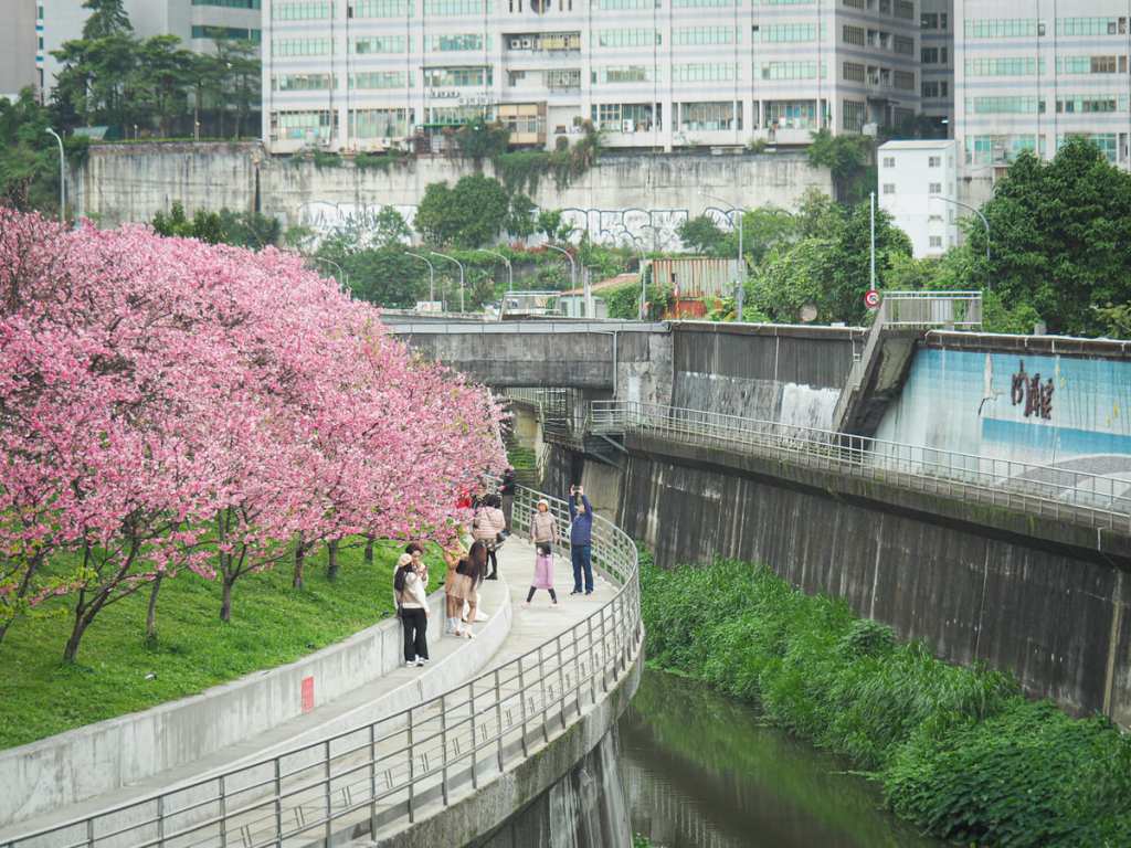
Every sakura season, the otherwise non-descript Lohas Park becomes a crowded riot of colour as the full blooms of cherry trees attract hoards of sightseers and photographers. The most blossom-dense spot is found close to the entrance of the Park, but more blossom, quieter trails, and some easy walking can be found along the banks of Neigou Creek, which straddles the boundary between Taipei and New Taipei.
Distance: About 5 kilometres.
Time: 1-2 hours.
Difficulty (regular Taiwan hiker): 0.5/10 – As easy as rolling out of bed.
Difficulty (new Taiwan hiker): 1/10 – Given that this is right on the border of New Taipei, some people might consider it as being in a far-flung location, but if you can figure out how to get here, you’ll be fine.
Total ascent: Less than 20 metres.
Water: A single small bottle will be plenty.
Shade: Most of this walk is not shaded.
Mobile network: Clear thoughout.
Enjoyment: If you visit during peak blossom season, the walk will be flowerful but somewhat crowded. Outside of this period, it will just be a pleasant stroll along an urban river.
When to visit Lohas Park: The first few trees usually start blooming in early February, but it varies from year to year. For a better sense of when to visit, it’s worth using Instagram to keep an eye on either the Lohas Park location tag or the page for Lohas Park Cherry Blossom Festival.
Accessibility considerations: While there are a few stretches of smooth and well-kept barrier-free paving, they are cut up and interspersed with steps and other obstacles. Benches are plentiful along the majority of this walk. In short, most of this would be suitable for someone capable of walking short distances on mostly flat trails.
Bathroom facilities: Some bathrooms (which looked temporary) had been installed at a couple of points. I’m guessing this park gets A LOT busier at this time of year.
Route type: There and back (or loop if you include the fact that you’re walking up and down different sides of a waterway).
Permit: None needed.
Jump to the bottom of this post for a trail map and GPX file.


Gaudy seasonal decorations welcome visitors to Lohas Park. This name, an acronym of “Life of Health and Sustainability,” is something I hadn’t heard at all before coming to Asia, but it’s used all over the place here.

A couple of paths wind through the park, but if you visit during the blossom season, you’ll find the majority of people are gathered around the patch of cherry trees planted along the raised embankment.


I visited in the first week of February, and the trees were in full, resplendent blossom, but evidently, this is a bit earlier than normal on account of the (overall) mildness of the winter this year.


A flock of chestnut-tailed starlings were entertaining the birdwatchers with their big lenses. This was a lifer sighting for me, and I was rather charmed by their antics. They bumbled from branch to branch, often swinging upside down to reach the best sources of nectar. The Taiwan Bird Guide lists them as an escapee species, which means they aren’t native to Taiwan and likely only established a population here when pets escaped.


To explore further, take one of the flights of steps heading down to the river, and follow it upstream. Once you pass under the first bridge, there’s another patch of cherry trees that hadn’t yet blossomed. Judging by the one or two buds clinging to the branches, they might be the late-blooming double-layered variety.


The path runs out once you reach this bridge and you have to climb some steps to reach the next section of trail.

More blooming cherries line the path along Lekang Riverside Park (樂康公園). They’re not as plentiful as those in Lohas Park, but the trail is far, far quieter.


Red arrows direct you down and over some stepping stones.

The path on the far side of the water has a patch of pretty white Formosan cherry (福爾摩沙櫻) blossoms.

To continue onwards to the Wufenpi Wetlands area you’ll need to cut over Kangle Street.


You can walk either side of the river, but I planned to walk a skinny circle route that kept the waterway to my right for as much of the time as possible.

A raised wooden walkway follows the course of the stream.


And because you’re standing at the same level as the trees’ upper branches, you get an up-close view of the blossom.

At Wufenpi Wetland Park, the waterway expands to encircle a small island.


Later on, I would walk back along the lower path by the water’s edge and cross over another set of stepping stones to explore the trail on the pool’s eastern edge


The further up, the quieter the trail gets. I passed a driving centre on the right and then a bus depot on the left, and then at some point, the paved trail ran out, so I took the steps down to the waters edge and began backtracking.

This angle offers a different perspective to the higher up path, and makes this place feel not quite like Taipei.


Back at Wufenpi Wetlands, I took the stepping stones to follow the lakeside trail.

A flock of noisy blue magpies squabbled in the trees and a free-range flock of chickens claimed the path.


In fact, birds were particularly abundant in this patch. I saw a few electric-blue kingfishers and a tree full of egrets.

I don’t know if this colour coordination was intentional, but I appreciated it.


Walking back along the far side of the river, I found myself following a road separated from the water by a flood wall.

Several flights of steps lead up and over to the waterside walkway, and if you visit during blossom season, it’s well worth popping up for a look because…

…from here you can get what is probably the best view of the Lohas Park cherry trees.


The whole slope is absolutely covered with the pink blooms, and even on a dull day, the effect is rather impressive.

Once you’re back here, it’s only a short hop across the bridge to the start of the walk and a bus stop that’ll take you back to the city.
How to get to Lohas Park
Google Maps address: Lohas Park is in Taipei’s Neihu District. It’s a densely built area, so parking is a little hard (save for scooters).
GPS location: N25 4.075 E121 37.070
Public transport: You can take the Brown Line (or Wenhu Line) to Donghu Station and walk up Donghu Street to the park. Alternatively, there are several buses that stop almost right by the park. In fact, so many services stop here that trying to list them all would be silly. Just plug Donghu Elementary School Bus Stop into Google Maps and see which bus is recommended.
Nearby trails:
- Bihu Lake
- Bihu Trail
- Cuei Lake and Neigou Shan Trail
- Dragon Boat Rock and Yuanjue Waterfall
- Egret Hill
- Kangle Shan
Lohas Park and Wufenpi Wetland Trail Map
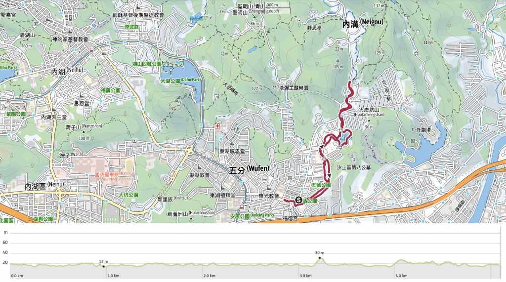
GPX file available here on Outdoor Active. (Account needed, but the free one works just fine.)
