
A Romantic Taipei Hike for all the Lovers and Trail Lovers
I can’t remember when I first saw someone share this route, but I’ve wanted to have a crack at it ever since I knew it existed. In fact, I’d previously mapped out my own heart walk in a similar area, but never got around to walking it. So when I saw this version combined a big and small heart, I knew it would be the one I ended up walking.

If I thought my other half would enjoy it, I would have saved this up for a special date, not told her where we were going, and then revealed the hidden message in the map at the end, but alas, I think it would end in an eye roll if I tried to drag Teresa around this loops merely for the purposes of demonstrating my feelings for her.
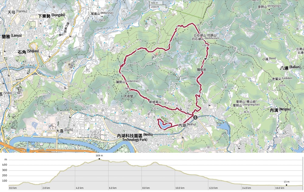
DISTANCE: About 16.5km.
TIME: 6-8 hours – This took me almost exactly six hours, but there are several factors which made me walk quicker than usual (I was trying to finish before an afternoon meeting, I didn’t need to stop and look at the map, and few of the sights were new to me).
TOTAL ASCENT: About 730 metres.
DIFFICULTY (REGULAR TAIWAN HIKERS): 3-4/10 – For length and elevation gain in the heat. It’s not technically challenging, but the cumulative effort required is on the high side for a suburban hike in Taipei.
DIFFICULTY (NEW HIKERS): 5-6/10 – There are a couple of steep climbs, and this would have been dauntingly long for me when I first set out.
SIGNAGE: Some sections are well-signposted with dual-language signs, and others have almost no signage at all. However, since this walk doesn’t have a specific peak as a goal, you’re not going to be able to rely on signage alone.
FOOD AND WATER: You’ll definitely need plenty of water and some snacks. I drank 2L on a warm May morning and ate a sandwich and salt candy. By the end, I was in dire need of being cooled down.
SHADE: Some parts are shady. I used an umbrella once the sun got bright enough.
MOBILE NETWORK: There were quite a few brief patches with no phone signal.
ENJOYMENT: These are my backyard trails, so this walk lacks the allure of the new for me, but despite that, it was still a great romp, taking familiar trails in unfamiliar ways.
SOLO HIKE-ABILITY: If you’re new to Taiwan, you might not feel comfortable walking some of the quieter sections of this by yourself, but in reality, it’s a pretty good trail to be walking solo on.
OTHER: You might want gloves for the first climb but otherwise, you’ll be fine without.
TAIWAN 100 MINOR PEAKS: Number 8 – Mount Daluntou
ROUTE TYPE: Loop(ish).
PERMIT: None needed.
Jump to the bottom of this post for a trail map and GPX file.
DIRECTIONS:


06:31 – The walk starts from the bottom tip of the heart at Neihu MRT Station. Leave the station via exit one, turn left onto Chenggong Road, then immediately left again onto Jinlong Road. At the Pizza Hut, turn right onto Lane 47. After about 100 metres, the lane splits in two (with a third alley on the right). Since it’s a loop, you can take either. I took the middle lane.


At the far end of the loop, head through the white archway leading to a police cemetery. Follow the road as it curves past the front of the main hall, then take the steps leading up through the graves. A graveyard does not feel like the most auspicious of places to kick off an ostensibly romantic walk, but it is what it is. At the top of the steps, turn left and follow the sloping path between rows of graves.

Before long, the trail reaches the end of the graveyard and heads into the trees. Look out for hiking tags indicating that you should take a left turn to scramble up a bank.

Very soon, I found myself at the first summit of the day: Mount Jiantou (梘頭山). Just beyond that, I met a pair of women hefting huge sacks of bamboo shoots. Currently (May), it’s the season for harvesting bamboo, so everywhere you go, you’ll find people doing it.


06:48 – Before long, you’ll join Bihu Trail. Turn right and follow the steps downhill. You’ll pass a side trail on the right this just leads to a rest pavilion, so keep heading downwards.

Bihu Trail ends at this reconstructed mine tunnel. In fact, the whole of Bihu Trail has been themed to remember the mine that used to be here. You can find rails and carts at different points along the walk.

Take a left turn once you have passed through the tunnel. Here, you’ll find yourself walking


Beyond the shrine, take the lefthand track and follow it down until you find the start of the trail.

For a short while, you’ll find yourself following an especially pretty part of the Taipei Grand Trail. (In fact, you’ll rejoin this trail later on, too.) A stone trail meanders gently uphill following the course of a stream and the water sounds were accompanied by the piercing screech of several inky-blue whistling thrushes.

07:05 – Look out for a metal bridge crossing the water to your right. Cross over and follow the path up through farmland. This is where the warmup portion of the walk ends!

Cross a second, even ricketier metal bridge and keep following the track as it turns right. You should find plenty of hiking tags to guide you through.


Once you’re under the shade of the trees, the trail begins a looooonnng climb that will take you all the way up to Mount Kaiyan with barely a metre of flat trail along the way (the climbing is pretty constant all the way up to Mount Bi, but this first part feels especially steep).

During one of my breath-catching pauses, I noticed some of the old stone walls. There might have been a rectangular shape to them, but some sections were so collapsed that it was hard to tell.


07:24 – After a twenty-minute climb, I reached a rocky overlook with unobscured views to the southeast and a partial view to the southwest. Looking east, you can see the weather observation station on top of Mount Wufen, as well as lots of lesser-known peaks in eastern New Taipei (I think one of the oddly-shaped nearer peaks is Xizhi’s Lion’s Head Mountain).

When the trail starts to level out a little and you find yourself walking through scrubby grasses and ferns, that means you’ve almost arrived at Dragon Boat Rock.

07:40 – Dragon Boat Rock is a mass of weather-smoothed rock protruding out from the forest with some impressive views of the surrounding area. Thanks to the off-kilter form of the wind-clipped trees, this spot lends itself to trick photos. People will lay on the surface just below the crack and act as if they’re dangling on the edge of a precipice. On this occasion, I didn’t linger long. There was just me and one other guy who kept angling his selfies to include me, but I’d forfeited my second coffee to get on the trails early, so I wasn’t feeling in the mood to play along.

A short path leads away from Dragon Boat Rock to the next junction.

07:43 – A small land god shrine sits at the crossroads here. Head straight over and climb the steps signposted as going towards Mount Kaiyan.


The trail is mostly paved, but I think the paths out this way probably don’t get much love because in the sections where it’s started to fall apart, it has just been left as it is. From a rock part-way up the climb, you can see the saw-toothed ridge from Scissors Rock to Mount Jinmian that you’ll later walk down along.


07:55 – When the trail reaches a junction, take a left and head up another few metres to Mount Kaiyan. Mr Sneak-Selfie was hot on my heels, so after fishing out my salt candy from the depths of my bag, I powered straight over and on down the trail leading away from the far side of the clearing.

On the far side of Mount Kaiyan, I encountered the first short descent of the day.


But after a brief respite of walking along a shady, flat path, I found myself climbing again. At the next junction, take the lefthand path and head towards this algae-encrusted fingerpost.

The top of Mount Bashihu is not particularly noteworthy. Three trails join up at a small clearing, and a marker sign attached to the triangulation stone tells hikers that it sits at an elevation of 458 metres above sea level. However, for me, it was a welcome indication that the vast majority of the day’s climbing was behind me. (Don’t let that trick you into thinking the rest will be easy!)

Take a left turn out of the summit clearing and enjoy the sensation of not climbing uphill for a while.

08:18 – Bear right at this next junction.


08:22 – The next junction is more of a wonky crossroads. Pass two turn-offs, first on the left, then on the right and keep on the straighter central trail. (The side trail cuts in from the road to a grave.)

08:28 – As you draw closer to Wuzhi Shan, the routes get a little more complex and interlaced. Five paths meet at this junction. Keep on the flattest, straightest path (on trail, on the right goes down to the road and there are two trails to the left).


Coordinated spider and hammerhead worm—both seen on this stretch of path. At the time of writing, I’ve seen a record three of these worms in the past month.

The trail here is wide, pretty and easy to follow.


08:34 – The next junction is a bit of a confusing one. You need to take two left turns in quick succession, so that it feels almost as if you’re doubling back on yourself.


08:38 – A few minutes after the last turn, I arrived at the summit of Mount Bi. At 517 metres above sea level, this marks the literal high point of the day. Despite having had breakfast not long before, I found myself feeling ravenous, so I paused for a few minutes to replenish.

08:47 – Suitably refuelled, I continued on. There’s only one other route leaving the mountaintop clearing, so there’s no confusion as to where to go. The path cuts its way down to a junction. Turn left here and rejoin the Taipei Grand Trail (this is the same section as earlier).


One of the trees at this junction held a small cluster of huddled caterpillars.

The next portion of the track is wide and gentle.


08:54 – Then when trails start splitting off, it narrows down a bit and becomes a little rougher. Most junctions are clearly signposted with Taipei Grand Trail signage, so it’s easy to follow, but in a few places you need to be a bit more careful. Go right/straight on at this first junction, then again at the next.


08:59 – Take a left here, then two minutes later a right.


Labyrinthine paths aside, this is a pleasant part of Taipei to be walking in.

09:12 – Keep heading straight where the dirt track joins a paved trail. (This is where you’ll leave the Taipei Grand Trail for good, it heads left to run by Sweet Water Lake.)


Follow the trail straight up all the way to Mount Daluntou. There are a couple of trails branching off on either side, but ignore those and continue onwards.

09:17 – The triangulation stone and numerous summit markets for Mount Daluntou.


Climbing Mount Daluntou will also allow you to tick off another of Taiwan’s Xiao Bai Yue (a list of 100 suburban mountains and hiking trails that are like younger siblings to the famous Baiyue). There’s a multi-level pavilion on the mountaintop and in good weather, it offers some great views of Yangmingshan.

Leave Mount Daluntou via the steps on the far side of the clearing.


Broad stone steps head downhill, but keep a careful eye out for this trail on the right. Actually, both the side trail and the steps rejoin soon, but walking the steps might make your heart a little wonkier.

09:27 – Turn right onto the path when you rejoin it. As soon as I went to take a photo, aunty insisted on posing for me.


The trail briefly joins the road by Dalun Lake. This is the dip in the top part of the big heart. Turn right onto the road and follow it all the way down to where it intersects with Bishan Road. Once you hit the T-junction in the second photo, cross straight over and head up the gravel trail.

A tiny land god shrine near the start of the path. This one appears to have been made out of a repurposed floor tile.


09:38 – The path slopes upwards to a junction with some benches. There are three paths leading away from here—take the trail branching off from the main path on the right. You’ll find yourself back on a narrow trail again.

The first of several bonus hearts I encountered on my journey. This one was residual concrete on a broken brick.


There are a couple of faint side trails along this stretch but at every turn, just stick to the more established main track. As you near the summit of Mount Dalunwei, there are several old pavilions that are slowly being reclaimed by the trees.

09:53 – A well-kept shelter sits beside the summit marker for Mount Dalunwei. I paused for a quick drink here before pressing straight over and down the steps.

The steps lead down to an odd area of open ground with a concreted-over track. Keep going straight following the track leading directly away from the steps.


10:02 – I think this area must have been more developed in the past, because in addition to crumbling pavilions and roads, there are also a few sculptures dotted amongst the trees.

Pass a turn-off on the right and continue along the ever-narrower asphalt trail.


At the next junction, turn left, then shortly afterwards, ignore a turn-off on the right.

10:13 – Turn right onto the road and head up towards a hairpin bend. I met a topless grandpa straddling the yellow lane dividing line to do his morning qi gong exercises.

You’re not on the road for long though. After just a minute or two, take the first trail on the right leading back into the treeline.


The trails here are clear but lacking in any signage. At both of the next two junctions, take the left path.

10:22 – The path rejoins a more established series of trails here by a mountaintop shelter and exercise area. In fact, at this spot, you’re once more crossing paths with the Taipei Grand Trail (although a different part of this time). The equipment was busy with people stretching and doing calisthenic exercises. Head straight over, keeping the shelter on your left.


The trail leading from the shelter to Scissors Rock twists and turns through the trees with several turn-offs along the way. At each junction, take the more defined path signposted as going towards Jinmian Shan (金面山), or Scissors Rock (剪刀石)—that means straight in the first photo and in the second either way works (they rejoin after a few metres).

There’s a steep extended climb that I found quite tiring after already having climbed so much.

Head straight over here. (The path on the right would take you to Huashan Pavilion closer to the start of the Jinmian Shan Trail.)

As you near the top, take an unmarked left turn.


10:38 – Despite having observed the city from this spot scores of times, the view is always impressive. Dawn, dusk and clear weather make it pop, but even on a grey day, it’s pretty spectacular. It’s also almost always popular with fellow walkers-on this occasion, a group of (probably) uni students were posing for photos on the overhanging rocks. I left them to it and continued on my way. The path down from here isn’t signposted on the peak. Head towards the large boulders on the eastern shoulder of the clearing, then look out for a path cutting down to the right just in front of the one in the centre of the left photo above.

The views continue to be a pleasant distraction for the first part of the descent, and at some points, it’s actually possible to see the lake at the end of the day’s walk.


10:48 – Pass straight over at a pylon, then straight over/left at the next junction about 30 metres further along. (Both of these side trails lead to different temples.)

10:53 – The top of Mount Jianmian is not anything to write home about. It’s just a plain concrete triangulation marker in a clearing.

But just a few steps away, I found another bonus heart!

The descent from Jinmian Shan is a rocky scramble with ropes to assist.


But almost as soon as it levels out, you’ll find yourself immediately climbing again. Head straight over at this junction and climb for a minute or two until you reach a rest and exercise area. This specific shelter and exercise area is where I often come to exercise instead of working out at home. Pro tip: take a brief detour to the top rear seating area behind the shelter. There are a couple of protruding rocks with great views back towards Scissors Rock. In the morning, these are usually occupied by grandpas doing tai chi, and my word, I bet you really feel the energy of the earth flowing through you up there!
There are also two paths leading down from this spot. The righthand one goes straight down to the road, but the one you want is the one that continues straight along the ridge.

From the hilltop pavilion, the path runs mostly downhill at a gentle slope before arriving at the next junction. Head straight over and up again here.


11:12 – Here you’ll come across the penultimate summit of the day, Zhusong Shan (竹嵩山), as well as another glimpse of Bihu Park—the walk’s final destination.

Once more, head straight over. The old folks who claim this summit as their morning hangout spot haven’t upgraded it as much as those at the shelter where I do my workouts, but they have (ill-advisedly) brought a whole load of cultivated plants up to the top and set up their own little garden. I can only assume that the actions of both groups aren’t strictly legal, but it’s another one of those areas where no one has ever tried to change anything, so no one will try to change anything.

The steps leading down steep and rougher than the previous section. I think it probably sees a lot less traffic than the rest of the paths around here.

A third bonus heart in the greenery beside the trail. At some point, I also passed the not-noteworthy summit of Xinpowei Shan (新坡尾山) and harvest a few bamboo shoots to cook up for a post-walk afternoon snack.


There are a couple of junctions to navigate. At the first, head straight, ignoring turn-off on the right, then at the second, turn left and start the final descent of the walk.

11:51 – The steep trail emerges onto Jinlong Road. Turn right here and head straight almost all the way back to Neihu MRT Station. I must have walked past this spot dozens of times, and I never once realised that there was a trail here.


Keep heading straight on Jinlong Road until you meet Neihu Road Section 2. Turn right and follow Neihu Road until you arrive at Bihu Park. There are lots of shops and restaurants on this road, so it’s a good place to grab refreshments if you’re flagging.

12:13 – When I reached the entrance to Bihu Park, I decided to make a clockwise loop. It wouldn’t really make any difference if you went counter-clockwise, but since I was planning to head towards Wende Station once I was finished, I didn’t trust myself to complete the loop if I walked clockwise. By this point, my feet were rather tired and I wanted nothing more than a cold coffee.


Walking around the lake needs no directions. It’s a simple, flat looping trail with a few pretty moments, but it’s also very popular with power-walkers, so make sure to be aware of them if you pause to enjoy the scene.

12:34 – I arrived back at the entrance to the park feeling very, very ready for a nice drink, a cold shower and a sitdown. Luckily, this is my neighbourhood, so I was home and in the shower in less than ten minutes!
GETTING THERE
Google Maps address: The walk starts from Neihu MRT Station and finishes at Bihu Park. If you want to drive or scooter, your best bet is to find roadside parking somewhere close to the ending point and then walk or YouBike to the start.
GPS location:
- Trailhead by the police cemetery – N25 05.170 E121 35.710
- Trailhead on Jinlong Road – N25 05.220 E121 35.270
Public transport:
- To get to the start, take the Wenhu (brown) Line to Neihu MRT Station.
- To get home, you can walk from the end of the trail to either Neihu or Bihu Park (Wende) MRT Station.
Further reading: If you want to read about this route in Chinese, you can check out this write-up.
Nearby trails: I was covering A LOT of familiar ground with this one. In fact, it’s safe to say that the stones my feet hadn’t trodden before were fewer than the ones they had. The list below covers most of the other posts on this site which overlap with this route at some point.
- Bihu Trail
- Carp Hill
- Taipei Grand Trail – Section 4
- Dragon Boat Rock and Yuanjue Waterfall
- Mount Kaiyan Trail
- Xiaoxitou Loop
- Xihu to Mount Dalunwei
- Taipei Grand Trail – Section 5
- Jinmian Shan Trail
- Neihu’s Path Less Travelled
NEIHU TWIN HEARTS TRAIL MAP
GPX file available here on Outdoor Active. (Account needed, but the free one works just fine.)

I hiked this trail today on my own — thank you for sharing it! It was a great experience. Unfortunately, I couldn’t start at the cemetery because there were too many territorial dogs around, and only one of them was on a leash. I would recommend choosing an alternative entry point to the route: Alley 12, Lane 60, Section 3 Neihu Rd. Cheers.
LikeLiked by 1 person
Thanks for pointing that out. That’s a real pity. I wonder where they’ve come from. There weren’t any dogs there at all the last time I walked that way.
It looks like you entered via the eastern entrance to Bihu Trail. Honestly speaking, that’s probably much more enjoyable that the spiderwebby bamboo tunnel. Perhaps the dogs saved you!
LikeLike
I chose this trail as my first hike after landing in Taipei 01/12 and found it quite challenging. Admittedly I was quite sleep deprived and jet lagged having only just arrived but I wasnt prepared for the steep rope climbing section early on. Also, at around 5k I couldn’t find the trail as it appeared to be completely overgrown. Perhaps this was unfamiliarity with how to navigate in Taiwan. There were indeed several ferocious sounding stray dogs at the cemetery but the most angry appeared to be on a leash so I pushed on through. Frustrated having to abort but a good insight of things to come for the rest of my trip.
LikeLiked by 1 person
Oh gosh. It sounds like you truly threw yourself in at the deep end! It’s definitely a bit of a hard pick to acclimatise yourself with. I hope you have/had some more successful hikes lined up for the rest of your trip.
LikeLike
I did the trail in opposite direction 2 weeks ago. It was a great hike. Beautiful lookouts, dense forest and impressive rock formations. The dry and not too hot January weather were perfect for such a hike.
And indeed the Neihu graveyard is “controlled” by some dogs, but I managed to sneak around them. The above mentioned Alley 12, Lane 60, Section 3 Neihu Rd would be defintely the better entry or exit point and still keep the heart shape.
Happy and a little exhausted I took the plane back the next day and I am looking forward my next stay in taiwan to try another path.
LikeLiked by 1 person
That’s great to hear that you found the previous hiker’s tips helpful. I’m sorry it took me so long to get back to you. I trust you’re all fully rested up after a long hike and flight home.
LikeLike