
Starting the Day on Top of Taipei’s Highest Mountain
I have tried several times to see sunrise from Taipei’s highest mountain. The first time, I’d planned it out using my timings from my regular sunrise spot, Jinmian Shan. To see the sunrise there, you can arrive about 10 minutes after true sunrise time, but I hadn’t factored in that being higher meant that I’d need to be more punctual. The second and third times were thwarted by the weather. Despite the sky being clear in the city, the closer I got to Mount Qixing, the more the clouds rolled in. On one occasion, I walked it anyway and sat at the peak as the sky transformed from dark grey to light grey. I think there was also a fifth attempt that was aborted before I even got out of my pyjamas. So, while I am yet to see a full, big open sky sunrise from the tallest mountain in Taipei, I’d say I got pretty close on this occasion. I will try again for sure.
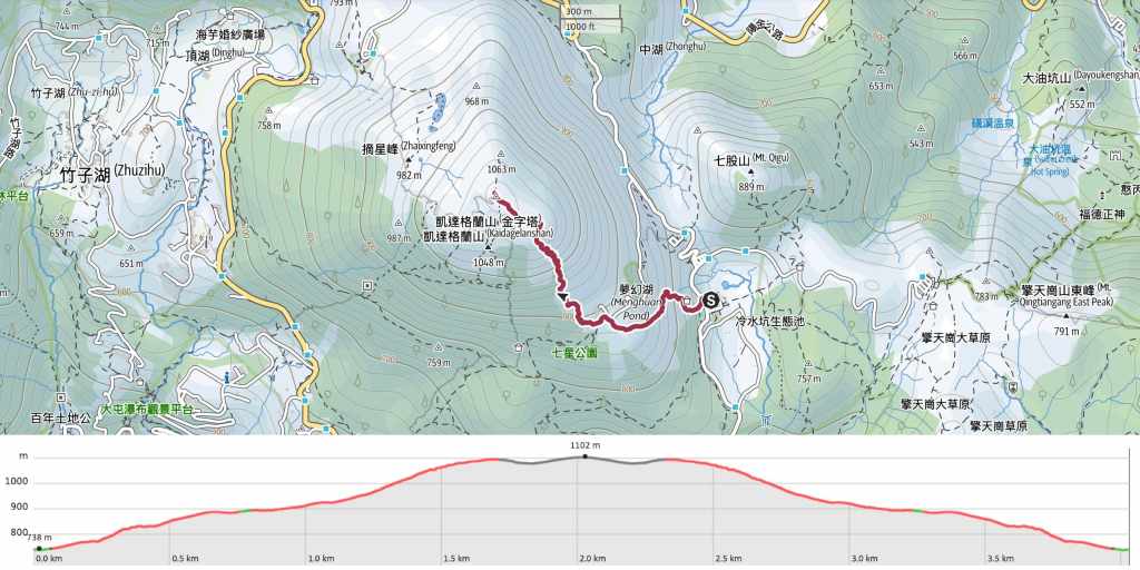
Distance: About 4km in total.
Time: 3(ish) hours. If you’re a quick walker (I don’t mean trail runner, just quick and not stopping), you can get up to the summit in about 50 minutes. At a more comfortable pace, it would take an hour or so. Getting down takes a similar amount of time. If you aim to arrive a little before the sunrise, you can easily end up spending an hour watching the light change.
Difficulty (regular Taiwan hiker): The walk itself is an easy 2/10 for seasoned Taiwanese hikers, it’s just a whole load of steps. However, dragging yourself out of bed in the dark adds significantly to the difficultly level!
Difficulty (new Taiwan hiker): 4-5/10 for the walking alone. The other route (from Xiaoyoukeng) is actually easier, but you’d be climbing the western slope, so if you were a bit late arriving, you wouldn’t get to enjoy the show. Transportation would also be tough if you’re new here and don’t have your own vehicle.
Total ascent: About 380m.
Water: I took a single 0.5L bottle of water, as well as a cup of coffee to enjoy on the top.
Shade: Almost no shade, but that’s not an issue if you’re walking this at dawn.
Mobile network: Perfectly clear throughout.
Enjoyment: If everything aligns and you get to enjoy the sunrise, this is a pretty special walk. You may even be extra lucky like me and see a Brocken spectre.
Other: Expect the summit to be cold. It is usually about ten degrees cooler than the temperature in the city, and often windy.
Route type: There-and-back (although point-to-point travel may be possible if you arrive by taxi and leave on a bus).
Permit: None needed.
Jump to the bottom of this post for a trail map and GPX file.

There are several routes up to the summit of Mount Qixing, but the two main ones are those which start from Xiaoyoukeng in the northwest and Lengshuikeng in the east. The walk from Xiaoyoukeng is marginally easier (and about 10 minutes quicker), but I picked the Lengshuikeng route for a sunrise walk because I figured that even if I missed the sunrise, I’d be able to enjoy the changing colours on my way up. The last several hundred metres of road have no lighting at all, and my scooter headlamp was woefully dim even on full beam, so I ended up driving with my head torch clamped in my teeth. The path itself starts just opposite the visitor centre carpark, and is steep right from the get go.

The path was full of these chunky toads, most of which were not as lively as this one.

At the first junction, take a right following the signs up to Mount Qixing East and Main Peaks.

The trail here is flanked by silvergrass, which outside of its blooming season, is scrubby and not too tall.


After climbing up to a pavilion (which looks like it’s slated to be demolished), follow the trail down past some picnic tables. If you look carefully at the photo on the right, you can see the glowing red light of the broadcast tower.


At the next junction, follow the path left and past the gates to the broadcast station. Not far beyond that, the trail splits in two. Take the right trail heading up the steps (the flatter one will take you to Qixing Park).

There were quite a lot of bats flying through the tunnel of bamboo.


After almost 50 minutes of climbing, I reached Qixing Shan East Peak. By this point, the sun was setting the eastern sky alight, but the clouds were rolling in.

Following the path down the far side of the east peak, I noticed a headlamp bobbing through the mist on the way back down. I’d already turned mine off by this point because it was light enough to see by.

Someone had already got their phone set up on a tripod by the time we arrived.

And a short while later, a trio of trail runners who seemed to be regulars showed up and started chatting with him.
The four of them had the prime spot to watch the sun pierce through the clouds.


There were also three more women seated on the benches when I arrived, and over time, more people came and went. It seems this is a popular spot regardless of the time of day.

The obligatory photo of Mount Qixing’s summit marker. It was really windy and about 18°C on this visit. Far cooler than in the city.
I stayed to watch the colours change for a while, then began to head downhill at about 5 o’clock. As I was passing over the east peak, I was treated to one of the most intriguing spectacles I’ve ever seen: a Brocken spectre. This bizarre phenomenon only occurs when the observer is above some clouds with a light source shining down from behind them, projecting their rainbow-encircled shadow onto the clouds. It was my first time witnessing such a sight and I felt very lucky.

On top of that, the trail itself was stunning in the honey-tinted morning sun.

All the other walkers kept stopping to enjoy the view.

In fact, the sky was so clear, that I could see Xue Shan, Taiwan’s second highest peak, rising in the distance behind the city.

Taipei 101 seen here framed by the trail. That towering far-off peak just visible above the clouds is Mount Nanhu (南湖大山).

The clear views continued the whole way down, and I was surprised to find myself back at the trailhead at 6:40 with the journey having passed so quickly.
How to get to the Qixing Shan Trail
Google Maps address: I started this walk from Lengshuikeng. There’s a 24-hour carpark here with scooter and car parking accessible with an EasyCard. If you would rather hike up from the Xiaoyoukeng Trailhead, you can find directions and a map here.
GPS location: N25 09.970 E121 33.790
Public transport: The Lengshuikeng trailhead is well-served by public transport, but not pre-dawn. If you want to get up here to see the sunrise, you’ll either have get there under your own steam, or find a taxi driver that will agree to take you. (If you visit in the daytime, the S15 bus from Jiantan Station will get you to Lengshuikeng Trailhead.)
Further reading: There are now several posts which visit Mount Qixing on this site. The original was one of the very first posts I wrote back in 2016 (and is therefore, of dubious merit). I’ve also covered it as part of the Taipei Grand Trail and as a night hike.
Nearby trails:
- Juansi Waterfall Trail
- Qingtiangang Circular Trail
- Qixing Shan Round Mountain Trail
- Taipei Skyline Trail – Section 6A
Mount Qixing Sunrise Trail Map
GPX file available here on Outdoor Active. (Account needed, but the free one works just fine.)

Fake aliens
LikeLike
@Yakoub
Allahou Akbar 🙂
LikeLike