
(Updated July 2023)
This short and pretty easy walk is a lovely short half-day foray into Yangmingshan National Park.
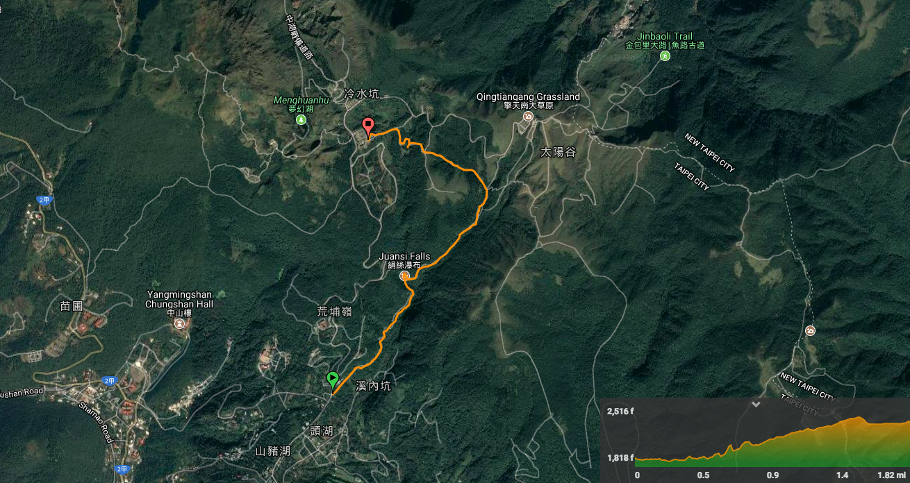
Distance: 2.9km
Time: 1 hour walking at a quick pace to keep warm.
Difficulty: 3/10 going up or 2/10 going down – you can’t really get lost here and the trail is paved the whole way. The only difficult comes from the slight incline and steps which become slippery in wet conditions.
Total ascent: 266m
Water: 0.5L for a quick winter walk was enough for me. There is a visitor centre at the end of the walk where you can get extra if necessary.
Shade: mostly shaded, a little more open towards the end.
Mobile network: ok, but with a few areas where it drops out.
Enjoyment: The path isn’t especially beautiful or fun to walk, but the waterfall is spectacular after rain, and being able to walk up to a place where you can enjoy hot coffee to warm you against the cold as well as dip your feet in a hot spring makes it extremely satisfying in cold weather. It is also public-transport accessible which is a positive.
Other: Aim to be heading down mid-afternoon in order to avoid the huge queues which form at the bus stops for the later buses – this is extra true if you go at the weekend or on a national holiday. Also, if you want to do more than just dip your feet in, there is a public hot spring bath you can use at Lengshuikeng (check Google Maps for the opening hours).
Jump to the bottom of this post for a trail map, GPX file and transportation information.

Walk 15-20 metres up from the Juansi Waterfall bus stop and you’ll reach the entrance on your right.

It starts out as an easy meander following a man-made watercourse on a gently sloping up. I’d decided on the upwards direction in an attempt to keep warm in the cold, (as well as because that would leave me next to a cafe when I finished).

After persistent wet weather, there were a few places where water runs run over the path. You needn’t worry about getting wet feet though because paving slabs have been placed so that you would have been able to walk up without walking in the water. On one visit, one of the streams I passed was warm to the touch, but all the rainwater had diluted it so that it was no longer that hot.

The slope on the left stretches up above the path, and the right drops down towards the noisy Lengshuikeng creek. As the steps start to get a little steeper, the water turns white from all the little cascades and small channels that it’s forced through.
A little over 1km into the walk, the path arrives at Juansi waterfall. According to the sign placed nearby, the fall acquired its name because it resembles a thread of spun silk falling through the forest. After several days of rain, I can report that it looks more like a fat silk rope.

The path continues up on a path which would have been very slippery if I were wearing anything except wellies. There are a few sections with some steps, but nothing too taxing.

Just beyond where the path crossed a stream, I turned left towards Lengshuikeng. (Right goes towards Qingtiangang.)

Again, over the bridge I took the left path towards Lengshuikeng. The straight-on path goes towards the road and the path on the left (just before the bridge), goes up to Qingtiangang.


I continued on, passing the moss-covered remains of an old cattle shelter from the time of the Japanese occupation. This section of the walk runs next to a small creek, maybe one which feeds into Lengshuikeng creek and the sound of the water is very soothing.

The path opens out to an exposed clearing with a viewing platform, and the remains of defense pillbox number six. The structures sit at another crossroads. This time, I headed straight on towards Lengshuikeng.

The path drops through a stand of tall pines which have been planted to either side, forming a kind of grand tree corridor.

At the bottom of the tree corridor the path splits. Both routes end up in the same place, but the left one takes you around Lengshuikeng Ecological Pond.

This is a popular spot with wedding photographers. On my most recent visit, there were no fewer than three sets of happy couples having their pre-wedding photos taken.

The pond itself was full of slender-stemmed yellow waterlilies, but I think I prefer it when it’s wearing its foggy coat.

The path climbs ever so slightly before arriving at Jingshan suspension bridge. This is another popular haunt for wedding photographers, and most times I’ve been here, there has been a queue of hikers and photographers waiting their turns.

After crossing the bridge, you quickly arrive at Lengshuikeng visitor centre, but the park has one final intriguing spectacle to share: 牛奶湖 or Milk Lake. It was once a point of sulphur extraction, but since falling out of use, the minerals in the pit have coloured both the rocks and the water. It was a surreal sight.

The trail concludes at Lengshuikeng Visitor Centre. To the left there’s a small café and toilet block, and to the right you’ll find the bus stop where you can catch the bus back down to the city.

Every time I pass through I head in (usually because it’s either so cold I need to warm up, or so hot I need to cool down, there’s rarely a happy medium). On my most recent visit, I was very happy to see that the café has started using reusable glasses and cups after years of only offering disposable—small progress! (There’s also a water dispenser upstairs if you just need to refill your bottle.)
How to get to Juansi Waterfall
Google maps address: 絹絲瀑布登山步道, 112, Taipei City, Shilin District
GPS location: N25 09.110 E121 33.726
Public transport: the S15 (a minibus), goes from just outside of Shilin MRT station. You need to get off at Juansi Waterfall/絹絲瀑布 – as far as I can remember, there is no english announcement for the stop, so either make sure you know where you’re going or let the driver know.
Further reading: this is the government website for this walk, it’s not amazingly phone-friendy though. Over here they provide a good example of how vexing the Yangmingshan buses can be to people who don’t read Chinese, they also do the walk in reverse.
Juansi Waterfall Trail Map
GPX file available here.
My new words learnt on this hike:
- 引以…為傲 / yǐn yǐ…wéi ào / be proud of… – technically the structure is more like ‘because of…feel proud‘ – or at least thinking of it that way makes it easier to remember.
- 無所謂 / wúsuǒwèi / it doesn’t matter – 你對我來無所謂 is a very unkind thing to say, it means something like you don’t matter to me or you mean nothing to me.

Pingback: 15 Ultra Instagrammable Places in Taipei (With Free Map) - Eternal Arrival