
If you ask a hundred people what the most beautiful or culturally interesting district in New Taipei City is, Yonghe will probably not be mentioned even once. Lacking the rural charm of places like Shuangxi or Pinglin, without the obvious historical interest of places like Ruifang or Sanxia, minus the reputation of places like Sanchong for being authentic, or Banciao’s appeal to growing families, Yonghe flies well under the radar. If I’m being honest, I’m not sure that this post will do much to persuade you that Yonghe has much to offer in terms of beauty and historical appeal, but I will try my damnedest!
I picked this corner of the city for my day off wander mostly because I wanted to get out of the house, but the weather has been so grotty that heading off into the hills isn’t really an option. I haven’t spent a whole lot of time in this area, and there was a secondhand shop that I wanted to visit, so it seemed sensible to try and occupy myself in the twin districts of Zhonghe and Yonghe for the afternoon. I noticed on the map that there was a waterway cutting a question mark-shaped arc through the streets and I figured that following its path would at least give direction to my wanderings.
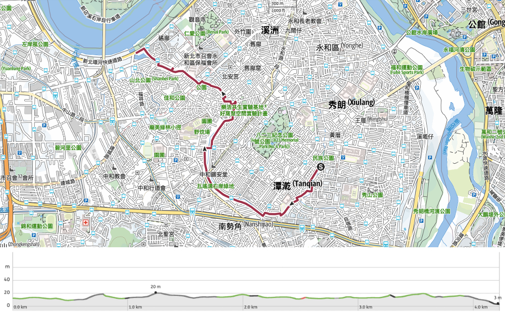
Distance: 4.2km
Time: A very relaxed two hours.
Difficulty: 0.5/10 – This is a casual city wander, the biggest challenge is not tripping over uneven curbs.
Total ascent: Almost nothing.
Water: You don’t really need to carry anything if you don’t feel like it. There are plenty of stores along the way.
Shade: On and off.
Mobile network: Clear throughout.
Enjoyment: This is a pleasant urban wander in a corner of New Taipei City that I haven’t spent much time in so far.
Route type: A to B with easy transportation.
Jump to the bottom of this post for a trail map and GPX file.

The waterway’s name is Wayao Canal (actually I think Wayao Ditch or maybe Channel might be a more technically correct translation, but no one wants to go for a walk along a ditch), and its headwaters are concealed somewhere under the concrete and construction around Fu-Hsin Trade and Arts School. But I didn’t start my walk there, instead, I headed for Minzhu Street and turned right away from the morning street market and into a small park.
(Note the children’s toy cars on the right. I remember seeing this somewhere else a few years ago and assuming that their owners had temporarily stopped playing with them, but no, it’s not uncommon to see these left in play parks, donated by families to the community, and in general it seems that no one needs reminding not to take them away.)

At the far side of the park Wayao Canal emerges from its sub-urban confines into the light of day – there is a very brief stretch where it can be seen a little further upstream, but this is where it comes out and stays out.


Various little communities along the way have carved up the land into parcels to use as they see sit. Some have gone with parking spaces, and others have opted for parks.

The beautifying efforts go only as far as the fences that border the canal, the water itself is a hideous, soupy teal colour and looks like it would cause an instant allergic reaction in anyone foolish enough to let their skin come into contact with it.


On the far wall close to Chih-Kuang Vocational High School there is a clue to Wayao Canal’s former life. Faded depictions of sailboats have been painted to look as if they’re floating on the water, along with characters reading Shuangcha Wharf (雙叉港). It’s almost unbelievable when you look at it now, but Wayao Canal was once a natural stream meandering its way through the land, its presence providing a natural boundary marker. Search for Yonghe District on Google Maps and you’ll see that for the most part, the shape of the modern city district is dictated in the north by Xindian River, and in the south by Wayao Canal.
The ghost of Shuangcha Wharf is located just downstream of the confluence where northern and southern tributaries of the canal meet. Back then, small boats would have been able to sail up here, possibly to fill up with the bricks and tiles that were churned out by the area’s many kilns. Yongehe and Zhonghe occupy old alluvial floodplains, so the area’s abundant resources of sand and clay provided ample natural resources for these industries to flourish. These days, this little neighbourhood is home to the largest evening market in Yonghe – even in the early morning evidence of its presence can be seen in the form of crates and stacks of trestle tables crowds the edges of the roads.

Beyond the old wharf, there is another relic, the site of a spring which previously fed the stream and provided water to the surrounding neighbourhoods. However, the spring is now managed by Taiwan Water Corporation and is whisked away before a drop of it touches the canal. Instead, the watercourse is now replenished by household wastewater – although this practise is being phased out in favour of channeling the grey water through pipes (hopefully so that it can be properly treated before it reaches the rivers.


Chickens roaming free: a sure sign that you’ve left Taipei City and stumbled into New Taipei! In addition to a few chickens, there were many stream-side gardens cobbled together out of whatever containers were available.

More urban gardening in evidence along the banks of the waterway. There is a cracking vegetarian restaurant right about here that I’d highly recommend if you’re passing through around lunch or dinner time. Their fried stinky tofu is genuinely stinky and comes served with crisp Taiwanese style kimchi that’s the perfect mix of sweet and tangy, and their medicine soup is the real deal. Apparently is a Taichung-based chain, but this is the only one in Taipei.
One neighbourhood has decorated the fenceposts along their stretch of the water with these exquisite tiles.


On Zhonghe Road I found myself crossing over once more and following a narrow trail sandwiched between the riverbank and a carpark.

A resourceful local has turned rainwater into a makeshift sink next to some exercise equipment.

It’s interesting that the width of the waterway doesn’t expand as it draws closer to where it joins Xindian River, it doesn’t even stay constant. There are spots – like this – where it seems to be pinched by the surrounding buildings and foliage, constricted by the city.


More creative use of materials on display here – an old raincoat has found a second life as a bike shelter, whilst on the far bank, a chihuahua with attitude watches community life unfold.

By this point, the drizzle had well and truly dropped any pretense of being benign, and it was coming down in unusually cold little bullets. This egret’s posture does quite a good job of summing up the overall mood of the weather.


The very final stretch of the walk was uneventful. I passed a temple which had decorated the waterside path with a scattering of elastic bands from bundles of incense, and a local government worker who had been sent out on a mission to obtain photographs of himself spraying insecticide into drains (this seems to be common practise in certain jobs – photos or it didn’t happen).

Almost two hours after I first joined Wayao Canal, I found myself at its final destination–Wayao Puming Station and the flood gates which mark where it flows into the waters of Xindian River. I can’t say that this was the most thrilling walk I’ve ever been on, but every walk has its day. Sometimes an urban wander is exactly what you need.
Getting there
Google Maps address: I started following the waterway from the market on Minzhi Street and stuck with it as far as Wayao Pumping Station.
GPS location: N24 59.875 E121 31.090
Public transport: If you’re coming from Central Taipei, you can board the 262 or 262 Shuttle from Taipei Station (the bus stop close to exit M5) and alight at Zhongxing New Village. From there, you just need to walk down Minzhi Street to the start of the canal. But I daresay there are other, more feasible options for people coming from different starting points. To return, you’ll probably find Google Maps more instructive than I am. There are lots of buses in the area heading to many different places.
Nearby trails:
Wayao Canal Path Map
GPX file available here on Outdoor Active. (Account needed, but the free one works just fine.)
If you enjoy what I write and would like to help me pay for the cost of running this site or train tickets to the next trailhead, then feel free to throw a few dollars my way. You can find me on either PayPal or Buy Me a Coffee.
