This short walk on the southeastern edge of Yangmingshan National Park is perfect for when you want something short, easy, and relaxing. The shady and often streamside loop also includes a stop at a coffee shop.
Distance: 3.7km with options to extend and shorten in a couple of places.
Time: About 2 hours (including a stop for coffee).
Difficulty (regular Taiwan hiker): 2/10 – Some climbing, some slippery rocks, and some challenges navigating.
Difficulty (new Taiwan hiker): 4/10 – In addition to the above, this trail feels more remote than it is, and that might be off putting for people inexperienced on Taiwan’s hiking trails.
Total ascent: A little over 100 meters.
Water: A single bottle should suffice, especially if you’re planning to take advantage of the coffee shop that’s along the route.
Shade: The trail itself if very shady, the roads at the start and in the middle are not. at
Mobile network: My mobile coverage was ok but weak for the duration of the walk.
Bathroom facilities: There is an unpleasant portaloo at the point where the trail meets Wuzhishan Industrial Road. Personally, I’d rather pay to get a drink and use the cleaner loos in the café.
Enjoyment: The absence of many views will mean this isn’t everyone’s favourite hike, but I really liked it. It’s short, has a coffee stop, and there’s little I like more than following a historic trail along a tinkling stream.
Other: There used to be two coffee shops at the top of the trail, Lavonna and Fingers Star City (11am to 2am except for Saturdays, when it opens a couple of hours earlier), of which, I prefered Lavonna because the owner used reusable cups and plates, unlike Fingers Star City, where everything comes in unnecessary disposable containers. However, as of 2025, this appears to have closed. On weekends, there’s also a third option a little further down the road called Coffee a Taste of Helen (open 7:30 to 12pm).
Route type: Loop
Permit: None needed
Jump to the bottom of this post for a trail map and GPX file.

The trail starts on the outer edge of a bend close to Fengguizui that just so happens to be the exact same starting point as section 4 of the Taipei Grand Trail and section 5 of the Taipei Skyline Trail.

As soon as you step off the road, you’re swallowed up by the trees, and it remains that way for the duration of the walk. The only exception is this lookout spot just a few metres along the trail.

An exposed rock to the right side of the trail offers views over a distant Taipei. It was already past midday by the time I was walking this trail, and the clarity of earlier had given way to haze. After checking the view, I headed back to the main trail and continued to follow the Taipei Grand Trail signage (there is another side trail here which leads up to a peak with two names: Mount Meihua North Peak and Shuangxigou Front Peak).

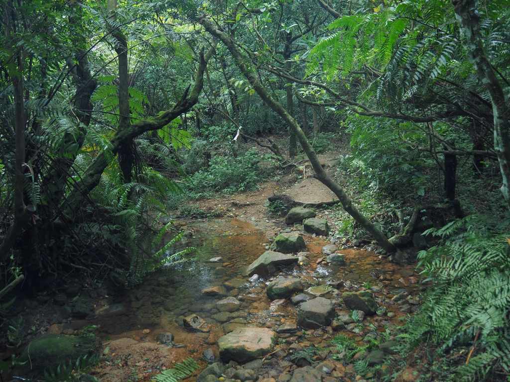
After a few minutes, the trail winds its way down to join a beautifully clear stream. At the point where I first fell in step with the water, another trail darts off to the right. On the map, it appears to link up with Mount Meihua’s West Peak. I was not in the mood for a longer loop, though, so I continued to head straight following the water.
Past experiences mean that I can’t walk past a hole like this without taking a quick look, and sure enough, this one was home to a very smart and/or lazy frog. The organic debris that had accumulated in the hollow had attracted a number of flies that were all buzzing around just centimetres away from the frog’s impassive face.


After walking for just ten minutes, I found myself at a spacious clearing with the remains of an old mountainside farmhouse. The path splits into a loop at this point.

I took the longer trail heading to the right so that the coffee shop I wanted to go to would have time to open before I walked up to the top. As it leaves the clearing, the trail crosses over the stream.

It had rained heavily in the preceding couple of afternoons, so the trail was something half between a shallow stream and a path.


To the left, a blink-and-you’ll-miss-it sign indicates the remains of a long-abandoned charcoal kiln.


There are many junctions along this section and the signage is all hand-written in Chinese, so you need to either be able to read those or have the map downloaded in order to find your way.
Head straight in the left-hand photo (the trail on the left is a steeper and more direct route to Mount, and the one on the right leads down to Mount Meihua West Peak). Then, in the righthand photo, bear leftish. It looks like a junction, but in fact, I think it’s just a clearing.


About five minutes later, I met a second trail branching off the the left to run up to Mount Meihua, but again, I kept to the flatter and straight trail and continued straight ahead.

There was about ten minutes of uninterrupted walking before the next side trail, this time heading down to on the right to Pamir Park( 帕米爾公園), but once more, I ignored it and stayed on the straight and flatter path.


Then, half an hour after leaving the clearing with the abandoned house, I found myself walking alongside Wuzhishan Industrial Road. Turn left before you reach the road and then just a couple of minutes later, hook a left following Taipei Grand Hike signage up towards Mount Meihua.

There are a couple of side trails leading down to the road along the way, but just stay on the main trail for now. It looks like this section has also been tended to by Taiwan Thousand Miles Trail Association (千里步道).


A Morrison’s fulvetta and a rock with a sign proclaiming it to be “Just a Small Mountain.”

At the next junction, the trail I took veers sharply to the right, still following signage for the Taipei Grand Trail, but if you’re into peak bagging, you can take a short detour to the left to visit Mount Meihua.

The peak is not particularly remarkable. A small concrete marker with several laminated peak signs sits in a clearing festooned with hiking tags.


After visiting the peak, I returned to the main trail. As the path starts to descend, ignore one side trail branching away on the left and keep heading towards the sounds of the road. Once you hit Wuzhishan Industrial Road, you can decide whether you want to keep going (in which case you need to follow the trail heading leftish and back down into the woods), or stop for a coffee break. I was firmly of the latter persuasion, so I headed up the road to the gathering of cafés and eateries.

Unfortunately, environmental considerations are far from top priorities for most of the establishments here, and most of them use single-use containers and utensils in order to cut down on the need to wash anything. Lavonna Coffee is the exception. The bosses are far friendlier than the boss of Fingers Star City too. Lavonna’s menu is all Chinese, but the boss speaks enough English to help you translate if necessary.
Update: This place has closed down, so if you’re looking for a drink, you’ll have to go to Fingers Star City.


I ordered peanut toast and an iced latte, which I sat in the shade to enjoy. There is also rooftop seating with a distant view of the city. Indeed, the cafés up here are open until the small hours (2:30am in the case of Lavona), and they’re popular with university students who ride scooters up the dark mountain roads to come and enjoy the night view.

Cooled and rehydrated, I returned along the road to where I’d left the trail. Once if made my way back to the trailhead, I took the lower of the two trails on the right which was signposted as heading to Fengguizui.

This part of the walk is on both the Taipei Grand Hike and Trail Skyline Trail, so it’s well-trodden.


Before long, the path falls back in step with the stream. This section of trail has obviously had a lot of low-key trail-building work done over the past couple of years—if you look closely, you’ll spot the telltale signs of TMI Trail’s hand-built footpaths.

At one point, the water crosses over the shallow stream. Sturdy stepping stones have been placed at regular intervals to save hikers from getting wet feet.

The scenery along this trail may not be especially dramatic, but it is really very pretty.


Soon, I found myself back at the clearing where an old house once stood, and from there, it was just a few more minutes back to the corner of the road where I picked up my scooter and returned home.
How to get to Shuangxigou Historic Trail
Google Maps address: If you want to drive yourself to the trailhead then you can head for Shangxigou Historic Trail. There is space for a few scooters right at the trailhead, and some car spaces a little further down the road on the right as you’re heading up. At the far end, there is probably space to park a scooter relatively close to the trailhead, but I’m not sure about cars. You will probably find it easier to use public transport for this one.
GPS location: N25 07.850 E121 35.930
Public transport: The M1 (市民小巴1) service will get you to Fengguizui bus stop, and you’ll need to follow the road up a little from there. It is a scheduled bus service leaving from Jiantan MRT Station. There are just a handful of buses each day, and on weekends you have to arrive at the first stop a good 2-30 minutes early to be sure of a seat.
Further reading: There’s no more English info out there for this trail, but you can find information in Chinese. Like this YouTube video:
Nearby trails:
- Dengfeng Canal Trail
- Taipei Grand Trail Section 3
- Taipei Grand Hike Section 4
- Taipei Skyline Trail Section 5B
- Taipei Skyline Trail Section 6A
Shuangxigou Historic Trail Map
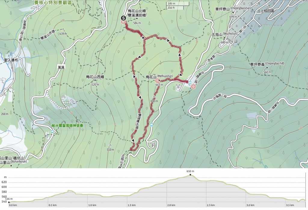
GPX file available here on Outdoor Active. (Account needed, but the free one works just fine.)
