
It had been quite a few years since we last paid a visit to this little place, and so when we needed a gentle day-out activity to do with Teresa’s mum, we decided to make a return trip. The trail has been improved quite a bit since that first visit. There are now a couple of extra trails and the signage has been significantly improved. It’s clear that locals are enjoying the improvements because we saw loads of families out for a little wander.

The only sadness to this return visit is that we were accompanied by our dachshund, Youtiao, the first time we came, but now she is no longer with us. This photo of her blending into the rocks was from that first visit. I can’t bring myself to delete her memory from this page.
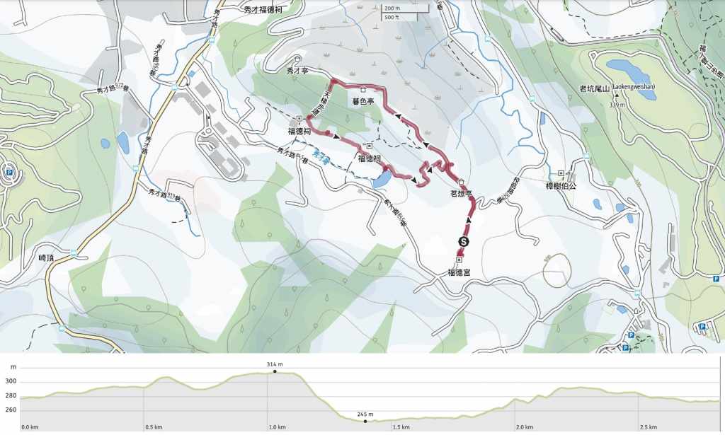
Distance: About 2.8 kilometres.
Time: Around an hour or so at a very relaxed pace.
Difficulty (regular Taiwan hiker): 1/10 – There are a few steps, but it’s not in the slightest bit taxing.
Difficulty (new Taiwan hiker): 2/10 – Even for those new to Taiwan’s hiking trails, this should be a comfortably easy walk.
Total ascent: About 80 metres.
Water: We didn’t take any because ut was cool and the walk was so short.
Shade: Much of the trail is quite exposed.
Mobile network: Clear throughout.
Enjoyment: This was is one to do with someone who’s not an experienced walker or on a day when you really don’t want to be cooped up inside. It’s not particularly special.
Bathroom facilities: I didn’t spot any toilets along the way.
Route type: Loop or there and back.
Permit: None needed.
Jump to the bottom of this post for a trail map and GPX file.


It had been quite a few years since we last paid a visit to this little place, and so when we needed a We parked just in front of a land god temple along with most of the other people doing this walk.

From the temple, follow the lane uphill. Although it’s a proper road, there is little to no traffic aside from pedestrians. I think we only encountered a couple of scooters.


As you climb, the lane takes you past tea fields and a couple of pavilions with information boards detailing various aspects of scholarly life of yore.

Teresa and her mum sheltering from the (very gusty) wind in their puffy jackets. I think this spot is notorious for being windy.

We visited maybe just a week or so after winter solstice, so at 3:30, the sun was hanging low in the sky.

The road keeps winding its way up through a tunnel of trees.


A new spur trail has been built since I last visited but Teresa’s mum didn’t fancy walking down only to walk up again, so we decided just to stick to the main path.

A couple of vendors had set up stalls selling oranges and leafy greens. “They’re very sweet,” one of the sellers said of her oranges. “If you don’t like sweet things, don’t bother buying them.”


We kept walking up to the high point of the road together. There’s kind of a view here, but it’s not an especially remarkable view.

Teresa and her mum turned back to return the same way they’d come from here, but I took the steps leading down to the left. The steps head through a scruffy forested area that was absolutely abuzz with Formosan blue magpies and grey treepies. One after another, they swept across the path in front of me, and their calls were so loud they blocked out other sounds.

At the bottom of the steps, I took a left turn. (The first time I was here, I don’t think this path had been built yet. That time, I went right and made a slightly longer loop.)


The trail cuts in front of a couple of extravagant graves, and to the right, you can see farmland through the trees.


Where the path rejoins a road, there is a small land god temple. These walkers had bought sweet oranges from the vendors which they used to pray.


Follow the road past a row of houses and up to a junction by a fish pond where you’ll need to turn left. A not-so-fierce guard dog rushed out to greet me. The closer I got, the lower she made herself, and by the time I was in front of her house, she rolled over, belly up to greet me.

At the fish pond junction, you’ll find a scholar perched on a wall above a sign naming the trail.


Follow the lane until it ends at a single-storey dwelling, then from there, head left up a track back towards the crest of the hill.
As I neared the road, I found myself walking in the pretty late-afternoon sun. This whole hillside is cloaked in what looks like cherry trees. A few trees had already burst into blossom, but I bet if I’d been a few weeks later, it would have been more spectacular.

I may have been too early for cherry blossom, but I was able to catch the last of the year’s silvergrass.

Once back on the road, turn right and from there, it’s just another five minutes back downhill to the temple we started from.
How to get to Scholar’s Hiking Trail
Google Maps address: Most people park their cars or scooters along the side of the road by this temple.
GPS location: N24 53.158 E121 08.286
Public transport: Theoretically it is possible to get buses here but in all honesty it’s probably not worth it if you have to go through the faff of waiting for buses.
Nearby trails:
My new words learnt on this hike:
- 學習困難 / xuéxí kùnnán / learning difficulties
- 上網看一下 / shàngwǎng kàn yīxià / go online, actually ‘online look a little’ but the translation is more like ‘take a quick look online’.
- 警察 / jǐngchá / police
Scholar’s Hiking Trail Map
GPX file available here on Outdoor Active. (Account needed, but the free one works just fine.)
If you enjoy what I write and would like to help me pay for the cost of running this site or train tickets to the next trailhead, then feel free to throw a few dollars my way. You can find me on either PayPal or Buy Me a Coffee.
