Perhaps the best hike in Yangmingshan Nation Park?
Ok, so that might seem a little hyperbolic, but I’m only half joking. This walk has certainly shot into my top three hikes in Yangmingshan National Park. Why? It’s just so perfect. I went on a beautiful October afternoon just as the silvergrass season was getting started. A cool breeze rippling across the tops of the grasses, bending them in dancing fluid motions, and as I followed the trail downwards, the grasses were replaced by a denser forest where a gentle mountain stream kept pace with me. I met a snake, nodded a greeting at an old god of the land, saw the half-collapsed ruins of old farm buildings, and finished off my walk with a visit to Xiaqigu Hot Spring. How could it be better?!
If you’re just interested in seeing the route and looking at the pictures, you might want to skip the next part, as what follows is basically just a brief attempt to demystify the numerous names for this trail.
Jinbaoli Trail is a confusing entity to define. The most simplistic explanation (and honestly, all you need to know), is that it is a historic route used by farmers and traders which used to connect Qingtiangang with Jinshan on the northeastern coast. However, it bugs me to leave things only half explained, so here we go.
When most people talk about the Jinbaoli Trail, they are probably only talking about the most popular portion of the historic trail-the part connecting Qingtiangang with Shanghuang Creek carpark. However, the full trail continues beyond that in both directions, starting in Jinshan and leading all the way to Shilin. It (or some of it) was likely built by the Ketagalan and Basai (also written as Basay) aboriginals who first inhabited the area. When Han settlers moved spread throughout Taiwan in the 1600s, the trail became a more established route for transporting goods between the coast and inland settlements. Goods traded included fish and sulphur that had been mined from the region’s fumeroles. When the Japanese arrived, they built a second trail which criss crosses the popular stretch of the Jinbaoli Trail at numerous points. This second trail was constructed for defence purposes, so it meanders up the hill via a series of switchbacks following a gradient that is gradual and wide enough to allow horses to pull heavy cannons (in contrast, the original traders’ route cuts steeply up the slope). This gentler, overlapping trail is known as the Japanese Trail (日人路), or the Cannon Trail (砲管路).
But it is not just the Japanese Trail that has multiple names. In Chinese, the Jinbaoli Trail is called 金包里大路, I’m not sure why “大路” (main/big road) is used rather than “古道” as with most historic routes. If I had to hazard a guess, I’d say it probably indicates that this route is much more well-established than other routes, but I’m not sure. However, one name is not enough, and Jinbaoli Trail also goes by “魚路古道”. If you try to find out about this trail in English, you’ll encounter a plethora of translation options. There’s Yulu Historic Trail, the Old Fish Road, Fish Road Historic Trail, the Fisherman’s Trail. As a wild card, there is also a third Chinese name used for this route, “河南勇路”. This has been translated both as the “Henan Soldiers’ Trail” and the “Henan Army Trail” after a group of soldiers from Hunan (yes, Hunan, not Henan-a quirk owing to the Taiwanese pronunciation of Hunan) who were stationed up in Qingtiangang.
Personally, I love the sound of “Yulu”, but if I had to pick, I would choose “the Fisherman’s Trail” because I think it best captures the essence of this route. Finally, this route is frequently split into north and south sections. The north part (魚路古道北段) joins Jinshan with Qingtiangang, while the southern section (魚路古道南段), runs from Qingtiangang down into Shilin.
So, with all of that information overload, what this post actually entails is the short and most popular section of the Jinbaoli Trail (aka the Fisherman’s Trail, aka the Fish Road Historic Trail, aka the Henan Soldier’s Trail).
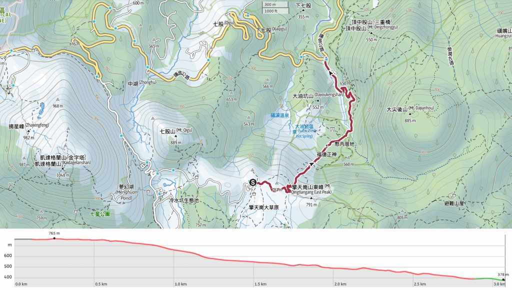
Distance: A little over 3km (one way).
Time: 2-3 hours to walk down. You could walk it in 90 minutes if you don’t stop, but trust me, this is a walk you’ll want to saviour. If you decide to do the walk in reverse (more on this later), you can expect the walk to take a little longer, particularly in hot weather.
Difficulty (regular Taiwan hiker): 2/10 – Lots of steep steps, but that’s it. This is an easy walk for anyon familiar with Taiwan’s trails.
Difficulty (new Taiwan hiker): 4/10 – This walk would be on the upper end of easy for people new to Taiwan. There are steep steps and quite a lot of junctions to navigate. Getting the transportation timing right would also be a little work for someone new to Taiwan.
Total ascent: Almost none. However, there is almost 400 metres of descent to cover, so if you decided to return the same way, you’ll have to climb that.
Water: I took about 0.8L with me and that was plenty on a pleasant October day. There is a water dispenser in the visitor centre at Qingtiangang, but nothing at the far end of the trail.
Shade: There is no shade at all while you’re up in the grassland, but as soon as you enter the treeline, it’s nice and shady.
Mobile network: Mostly clear, but there were a few spots where signal was weaker.
Enjoyment: I absolutely loved this walk. It’s pretty, gentle, and contains historical elements. It’s one I’d highly recommend.
Other: To enjoy the sivergrass season, you’ll want to visit in October or November.
Bathroom facilities: There are toilets both at the start and end of this trail.
Route type: Either point-to-point or there-and-back depending on how you walk it.
Permit: None needed.
Jump to the bottom of this post for a trail map, GPX file, and transportation information.
Directions:

I arrived at Qingtiangang after a deeply unpleasant minibus ride. The driver kept stopping at every single stop and opening the doors, seemingly deaf to the yelps and protestations of the passengers who were crammed in so tightly that they prevented the door from being able to properly open. And naturally, once those doors were open, everyone waiting attempted to board even though there was barely room to breathe. Our driver then sped around the bends as if auditioning for the role of stunt car operator. After taking a moment to recompose myself, I set off up the steps beside the small visitor centre shop.


From there, I took the familiar trail towards the temple, then headed towards the crowd of people at the start of the Qingtiangang Circular Trail. Instead of turning right to walk along the fenced walkway, keep heading straightish.

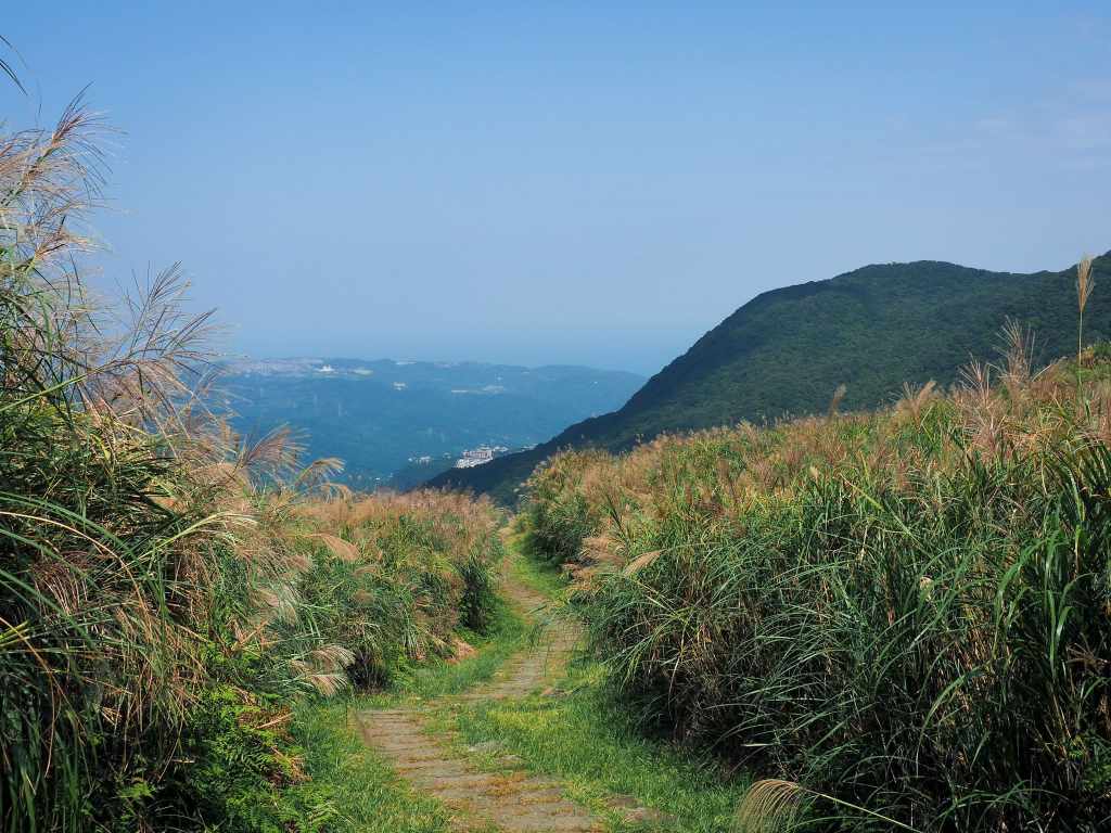
I had forgotten that it was silvergrass season, so I was delighted when I arrived to find the trail gilded with these beautiful stems.

The area grazed by the cattle and used as a picnicking area by visitors stood out as a vivid green patch among the shimmering silvergrass.

After walking for 5-10 minutes, you’ll arrive at Jinbaoli Gate (金包里大路城門). This current gate is a replica, not the original.


Head through the gate and start the descent. At the bottom of the first flight of steps, veer right, then almost straight away, take a sharp left and head down more steps.

The views are magical, even more so with all the silvergrass everywhere. And once I left Qingtiangang Grassland behind, there were very few people.

This is one of the places where the Jinbaoli Trail intersects with the Japanese Trail. The latter is the gentler, unpaved route, but I was following the historic trail, so I took the steps on the left.

Looking back the way I’d come, I could see the sunlight catching in each fluffy head of silvergrass.


At two more junctions, the Jinbaoli Trail crosses straight over the Japanese Trail. As the trail draws close to the second of these junctions, it is joined by a small stream bubbling up through the rocks to run parallel for a short way.

This grand boulder has been nicknamed the “Master Stone” (大石公) and historically functioned as a boundary marker for the trail’s earlier inhabitants. The section of the trail that falls to the north and downhill of the rock was maintained by Jinbaoli residents, while the uphill southern section was the responsibility of those living in the (present-day) Yangmingshan Area.

More than just being a boundary of responsibilities, the rock also marks the point at which the mountainside vegetation starts to shift. Just a short distance further along the trail, the open skies and swaying grasses are replaced by well-established secondary forest with the occasional clump of bamboo. There are traces of past residents pretty much everywhere you look once you enter the trees—like this fallen-down building that’s now inhabited by trees.


The trail falls instep with a gentle stream, and at this first stone bridge, I encountered the cutest big-eyed rat snake. Its head reared up about 20cm from the ground as it eyed me suspiciously before continuing with its hunt. I watched it probe in and out of the rocky crevices in the stream bed before slithering effortlessly up into the branches of a nearby shrub.

In a clearing, a red brick land god temple sits to the left of the trail, and a small stream flows to the right. Inside the temple sits a peaceful-looking deity. I reckon I’d be pretty calm too if this was my home.

The old stone bridges on this trail are absolutely exquisite. Long, low stone slabs are fitted snugly onto large boulders and wedged in place by more stones at either end of the span. They are a sign of the old skills and craftsmanship that have largely been replaced by concrete construction.

More signs of people from the past come in the shape of these stepped farming terraces. After the path crosses to the far side of the stream, the land on the right takes on a strange, sei-open quality that is very obviously unnatural. A second closer look will reveal the remnants of stone walls demarcating flat parcels of land. According to a nearby information board, these were previously used a farmer called Xu Zai-Zhi, who used them to cultivate rice, sweet potatoes and bamboo shoots. When Xu could no longer afford the rent, the Lai family took over and tried to use the land to farm cattle, but they too found it hard to eke a living out of this small patch of earth. And so the terrace farm was abandoned.


It is just such an exquisitely pretty section of trail. It’s the kind of place you want to linger in.

There are a number of small cascades interspersed with shallow pools and I bet you would see a lot of wildlife passing through if you were to set up a trail camera.

At the bottom edge of the terrace farm, there’s longer stone bridge crossing another tributary of the stream.

A seismic activity monitor half-buried in the earth beside the trail by researchers from Acadamie Sinica’s Institute of Earth Sciences Department.


The trail descends to a rest area beside the part-rebuilt structure of an old house. The old Hanbing Residence (憨丙厝地) is one of many previously inhabited places along the way. Bilingual information boards describing the history of the area and trail have been hung up on the walls.

At this junction, take a left and continue downhill. (The path joining from the right is the Japanese Trail again.)


The path runs down to cross over Xuyan Bridge (許顏橋). You can’t see it from above, but the bridge has a lovely elegant archway.

The path takes a left turn down a flight of wooden steps. (The original trail carries straight on, but it has been rerouted.)

A trailside waterfall that would be a lot prettier without all those ugly pipes.


Not far beyond the waterfall there are the remains of a trailside stove that was used by workers to cook their meals. Once more, the trail takes a left turn and heads down some steps.

As you draw close to this end of the trail, the trees on the left open up to give you a view of mineral-stained rocks in the creek.

The very final section of the trail before joining the road is a track with views over Xiao Guanyin Shan.


I arrived at the carpark and toilet block, then headed straight down the road to find the bus stop.

The 1717 heading back to Taipei leaves from the far side of the road a little to the right of where you come out.
How to get to the Jinbaoli Trail
Google Maps address: The walk starts from Qingtiangang Visitor Centre and ends at Shanghuang Creek carpark. There is parking at both ends, but you cannot drive up to Qingtiangang on weekends and national holidays. Also, the Shanghuang Creek carpark is free. I walked this as a point-to-point hike, but it would be easy to park at one end and walk there and back.
GPS location:
- Qingtiangang trailhead – N25 10.020 E121 34.470
- Shanghuang Stream carpark trailhead – N25 10.675 E121 35.005
Public transport: You could do this walk in either direction, but if you climb up from Shuanghuangxi Bridge bus stop, you’ll be able to get a bus down without the risk of having to wait so long.
- Getting to Qingtiangang – Take the S15 minibus from outside Jintian Station. The bus also passes Shilin Station, but take it from someone with hard-won experience, you do not want to catch it anywhere except the first stop on the route. Ride the bus all the way to Qingtiangang.
- Getting back from Shanghuang Stream – Take the 1717 bus from Shanghuangxi Bridge bus stop back to Jiantan Station.
Nearby trails:
- Juansi Waterfall
- Qingtiangang Circular Loop
- Taipei Grand Trail – Section 3
- Taipei Skyline Trail – Section 6B
Jinbaoli Trail Map
GPX file available here on Outdoor Active. (Account needed, but the free one works just fine.)
