
A Short and Sweet Loop Walk in Chuanghua County
After climbing Mount Jinganshu the day before, we ate in Nantou, showered at the nearby Nantou Service Area (because we are classy like that), and decided to sleep in the car again rather than head home the same evening. So it was, that I found myself waking up in a car park at the entrance to Tianzhong Forest Park. It seemed churlish not to pay the trails a visit, so I left Teresa to go and find her morning coffee, and I set off for an energising pre-breakfast walk. The walk greatly surpassed my expectations, and I am thoroughly glad I made the effort.
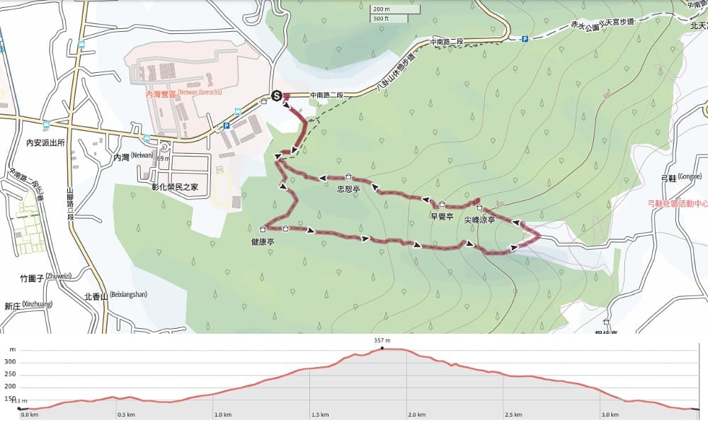
Distance: 3.5km with the option to extend it a bit if you visit the tea trail at the top.
Time: 1½-2 hours.
Difficulty (regular Taiwan hiker): 2/10 – This walk is tiring because of the steps, but not difficult. The amount of elevation gain is enough to put it in the moderately easy category.
Difficulty (new Taiwan hiker): 3-4/10 – The steps will be tiring if you’re not used to them (especially in the warmer months), but not dangerous or difficult.
Total ascent: About 250m.
Water: I took a 0.5L bottle and drank it all.
Shade: There’s dappled shade most of the way. On a sunny June morning, I resorted to using an umbrella.
Mobile network: Perfectly clear signal throughout.
Enjoyment: This is fun exercise with some nice views of Changhua County. The fact that you’re climbing along ridges makes it a little exciting too (there’s never any sense of peril though, so if you’re scared of heights, this walk shouldn’t present an issue).
Route type: Loop
Permit: None needed.
Jump to the bottom of this post for a trail map and GPX file.


On a sunny weekend morning, by the time we had woken up, the car park was full and vendors selling fresh produce had gathered around the bottom of the trail.

For the first couple of hundred metres, the path is a narrow concrete track leading gently upwards. At a bend, a pavilion sits beside a clearing and a group of stretching aunties had gathered (energy was being split 90:10 between chatting vociferously and exercising).


The top of the track marks the start of the loop section. The flatter trail on the right seemed more appealing to me, so I set off to walk an anti-clockwise loop.

A compacted dirt trail curves around the side of the hill. It’s both pretty and gentle.

When the track reaches a pavilion, all the gentleness ends! Here, the trail takes a sharp left turn and begins to climb straight up.

Steep steps with railings on either side march relentlessly upwards, and within minutes I was sweating buckets despite it still being very early in the day.

For the most part, the path is nicely shaded, but in a few places, a gap in the trees makes it possible to look out over Tianzhong.

My attention was also taken by the huge numbers of tiny ants swarming all over the place. They were gathering on many of the boards that formed the steps, and the handrails were unusable because they were covered with ant processions. Maybe the heavy afternoon showers had unsettled the colonies.


As the walk nears the apex of its climb, a gap in the trees shows a very steep climb on the opposite ride (where I’d be walking down just a little later). I looked at it and felt glad that I’d chosen to come this way instead of that way, but of course, my smugness was roundly punished. The final part of the climb on both sides is quite equally steep.


The trail hits the red earth of the plateau and heads towards some farmland before curving to the left to begin its descent.

Some people take a detour to the right here to visit Beitian Temple and a tea trail, and I was definitely tempted by the promise of coffee just a few minutes away, but I decided instead to keep going and not keep Teresa waiting for her breakfast for too much longer.

The trail passes some farmland where I saw something like bamboo being grown in rows. As an aside, that guy in the above picture is one of those guys. The creepy cling-on ones. I first encountered him about halfway up the climb. I accidentally made eye contact and from that point on, I just instinctively knew I wouldn’t shake him. Sure enough, I was proved right. No words were spoken, but for almost the entirety of the rest of the walk, he either walked a little ahead of me, stopping when I stopped, or else allowed me to get just in front of him and then speed up to keep up with me. If I waited longer than normal and thought he’d gone, then I’d turn the bend and there he was trying to look as if he wasn’t looking back up the trail to see if I was coming. If I tried to speed up, he’d speed up too. At no point did I feel concerned for my safety, he wasn’t giving off those kinds of bad vibes, but he certainly seemed intent on remaining in close proximity for some reason and it was really fucking annoying. I’m not the most sociable of people, but neither am I a misanthrope. I had pleasant short chats with a couple of people who engaged me in conversation—I’m not averse to talking to people as long as they don’t pull stalker-esque moves.
So, in case it’s needed, here is a brief PSA: It should go without saying, but if you see someone walking alone (maybe especially a woman), don’t behave like this. By all means, say hello, but don’t give the impression that you’re going to loiter with them the whole way. Having to constantly assess whether you need to be concerned about your safety really takes away from the enjoyment of a walk.


As it starts to head downhill, the trail passes an extensive exercise area full of seating and outdoor gym equipment.

There are also a couple of rest pavilions on the way down, the first of which had been commandeered by a large group of chattering retirees, and another which seems to have become a mountaintop shop run by an auntie.

As it nears the bottom, the trail begins to level out again and feels both spacious and airy.
There’s one final junction. I went right, but in fact, either would get you back to the start of the loop.
From there, I walked back down the last few hundred metres to the carpark. I thought I had got rid of my hanger-on. I hadn’t seen him in about ten minutes, but then when I got to the car park, in a classic creep move, he suddenly appeared from behind me and started trying to get my attention with “小姐!小姐!” Luckily for me, I had seen him coming out of the corner of my eye and already had Teresa on the phone, so I got away with just nodding a reply to his rather stupid question (“Did you walk up from here?” – of course, we had been walking up at the same time). I motioned that I was on the phone and thankfully that was enough to get rid of him. I must say though, that sneak move of waiting for me to arrive and then appearing in a way that I couldn’t avoid, that took him up a notch from harmless to I-might-need-to-worry-about-this-creep.
Don’t be that guy. Just don’t.
And for any women reading this, don’t let this experience put you off hiking in Taiwan. In all my years here, I have very, very rarely come across this kind of fuckwittery.
How to get to Tianzhong Forest Park
Google Maps address: I started and finished the walk at the large free carpark next to Gushan Temple. Other people seemed to be doing the walk the opposite way (starting and finishing at the top), but I can’t work out where they would have parked.
GPS location: N23 51.220 E120 36.670
Public transport: The local train will get you as far as Tianzhong Station. From there, you can either catch a bus from the stop outside the station to Ren Ai Villa bus stop (the 6927 Via Tianzai and the 6928A Extended Tianzhong both go the right way). However, depending on when you arrive, you might find it quicker to walk. Getting back is the same, just in reverse.
Further reading: The local government has a couple of brief pages detailing this trail, but they’re not particularly informative. This post has a description of the route in Chinese.
Nearby trails: There are a lot of walks to be had along this little hilly plateau.
- Baguashan Wander
- Dengmiao Trail
- Heng Shan
- Longguomai Forest Trail
- Sanqing Temple Forest Trail Eastern Loop
- Sanqing Temple Forest Trail Western Loop
Tianzhong Forest Park Trail Map
GPX file available here on Outdoor Active. (Account needed, but the free one works just fine.)
