Sometimes when Taipei’s weather is grey and rainy for extended periods of time I find myself itching to get out and do a little walking anyway. Given the fact that prolonged rain here often causes landslides, it is obviously not smart to hike in rain-soaked areas, so what is the solution? To head somewhere drier of course. Not everyone will fancy sitting on a train for a couple of hours in order to essentially just go for a stroll, but as someone who enjoys train travel, for me it seems like a win-win situation. There are a fair number of walks that can be reached in a day from Taipei if you’re in search of new scenery and don’t mind an early start.
Distance: 1.8km – if this isn’t enough you can always combine it with another nearby trail.
Time: 45 minutes to an hour.
Difficulty (regular Taiwan hiker): 1/10 – navigating the maze of trails is the only difficult element here.
Difficulty (new Taiwan hiker): 3/10 – slippery trail surface, lots of unmarked side trails but the walking itself is easy.
Total ascent: Negligible, around 50 metres.
Water: A small refillable bottle should suffice – you can top up from the water dispenser at the temple.
Shade: Pretty well shaded, I was alright without any extra protection on a sunny October morning.
Mobile network: Clear throughout.
Enjoyment: When I visited in autumn this was a great birdwatching walk, the trees were bursting with avian life in all varieties.
Other: There are quite a lot of feral dogs in the area, and although none of them showed any signs of aggression when I visited you still need to be careful.
Permit: None necessary.
Jump to the bottom of this post for a trail map, GPX file, and transportation information.
There are several trails spreading out from the central hub of Sanqing Temple, known collectively as either Taoyuanli Forest Trail, or Sanqing Temple Forest Trail depending on where you look. Although they all seem to link up, the map separates them into three main sections, the western Sanqing Temple Forest Trail, the eastern Sanqing Temple Forest Trail, and Longfenggu Forest Trail. This post covers the western side of Sanqing Forest Trail.

To do a clockwise loop I started from an unmarked trail head just at the entrance to the car park for Sanqing Temple. (If you need to top up your water bottle or use the bathroom you can do so at the temple before setting off.)

Right from the get go it was evident that I was no longer in Taipei – instead of the rippled layers of low-level hills that I’m familiar with, the views were just planes stretching out until they melted into the sea.

Just a couple of minutes into the trail I passed the triangulation stone for Kengzinei Shan, a 154m high peak with a clearing and a few stacked plastic chairs that are presumably used by the early risers who flood the lower elevation hills of Taiwan at dawn.

A gap in the trees on the right gives you a view over Sanqing Temple.

And to the left it’s just a whole load of flatness – I think this should be Xiushui Township, but it’s hard to pick out any distinctive features that would let you know where exactly you’re looking.

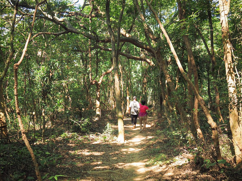
The trail dips down to the first of many unmarked junctions. Here I kept left, heading northwest and away from the temple, the older gentleman stopped to ask me (in English) if I knew where I was going and I said I’d never been before, but should be ok and he powered off on his morning stroll.

The next point of note that you pass is this electricity pylon. Later I found myself passing back this way just before exiting the trail.

At the next junction keep left once more, the trail on the right is where I would rejoin my own steps about 45 minutes later. There are a number of other trails joining from the right, just ignore them and keep sticking to the outer edge of the loop.

There were a few other walkers out, but I must have been the youngest person there by at least 20 years.
There was also an awful lot of bird life to be seen and heard in the woods. As I was going down this little stretch I passed a fruiting Japanese superb fig which was all aquiver from the fluttering of many different species. I spotted light-vented bulbul, Japanese white-eyes, black bulbuls and several other species that flitted around too quickly for me to identify.

The trail continues its downwards route until it hits a bamboo grove and seems to flatten out. The walking is made a little tricky by the composition of the trail surface (a combination of dry, sandy soil and potato sized pebbles), they conspire to shift underfoot and you have to be very deliberate in placing your steps.

From this point the trail curves right and seems to start heading back towards the temple. There are a number of minor side trails, but I was already off of any trail on the map I was using so I stuck to the most defined route.

For a while the trail keeps right of a dry gulley, then it veers left and crosses over it through another little patch of bamboo. The trail climbs up the far side of the gulley, then immediately it splits in two. I knew that going right would soon take me back to Sanqing Temple, but I wanted to explore this side of the trail a little more first so I turned left and started heading down the other side of the gulley.

This area was full of star fruit trees and their many overripe fruits made the air heavy with an almost intoxicating, fruity pungency.
The fruit seemed to be drawing in almost as many birds as the earlier fig, and I was lucky enough to spot my first ever white-rumped shama here.

There are a few trails criss-crossing all over the place here, keep right at this junction…

…then keep right again…

…then pass an old water container (one of many signs of the land here previously being used for farming)…

…and then finally right a third time. At this point you’ll now be doubling back on yourself once more and heading in the direction of the temple again.

Soon I found myself back almost at exactly the same spot where I’d deviated from the main trail by veering left (just to the right of the frame here). At this point you just need to merge onto the original trail and head straight.

The trail climbed a short way towards a bougainvillea vine that was in pretty bloom.

Beyond the vine the trail tracks down a little once more before quickly returning to a junction that I’d already passed. Turn left here, back onto trail that has already been covered.

Walk back past the electricity pylon, then turn left (not back up the same way you came from).

The dusty path gives way to concrete, and curves around the side of a hill towards the temple (the trail on the left here goes towards the nearby university campus).

Just as I was nearing the end of the trail I looked up and caught a glimpse of this military plane (a C-130 according to people who know more than me). Nearby Taichung is home to Ching Chuan Kang Air Base so I imagine they’re probably just background noise for people living and working in the area.

Naturally I couldn’t pass by without going and having a look at the temple. There is a separate external structure housing the Generals of the Five Camps, and the main building is a split-level affair with altars spread over both floors.

The two main deities enshrined in Sanqing Temple are Taishang Laojun (太上老君) and the Jade Emperor (玉皇大帝), although this pair is accompanied by many other figures from the Taoist pantheon.
How to get there
Google maps address: the walk starts and ends at Sanqing Temple, there is parking space for around a dozen cars and a slightly greatner number of scooters.
GPS location: N24 03.630 E120 33.945
Public transport:
- To start from Sanqing Temple you can catch either Changhua City 2 bus as far as Changhua University of Education, from Changhua Station, then walk along Baoshan Road for about 15 minutes until you reach the turn off for Sanqing Temple on your left.
- Alternatively you could take the 6911 (also from Changhua Station) and ride it as far as Caociting bus stop, then walk along Baoshan Road for about 10 minutes until you reach the turn off for Sanqing Temple on your right.
- Or if you have a scooter license and don’t fancy waiting for the bus you could always rent a scooter from the store that’s opposite the train station.
Nearby trails:
Sanqing Temple Trail Map
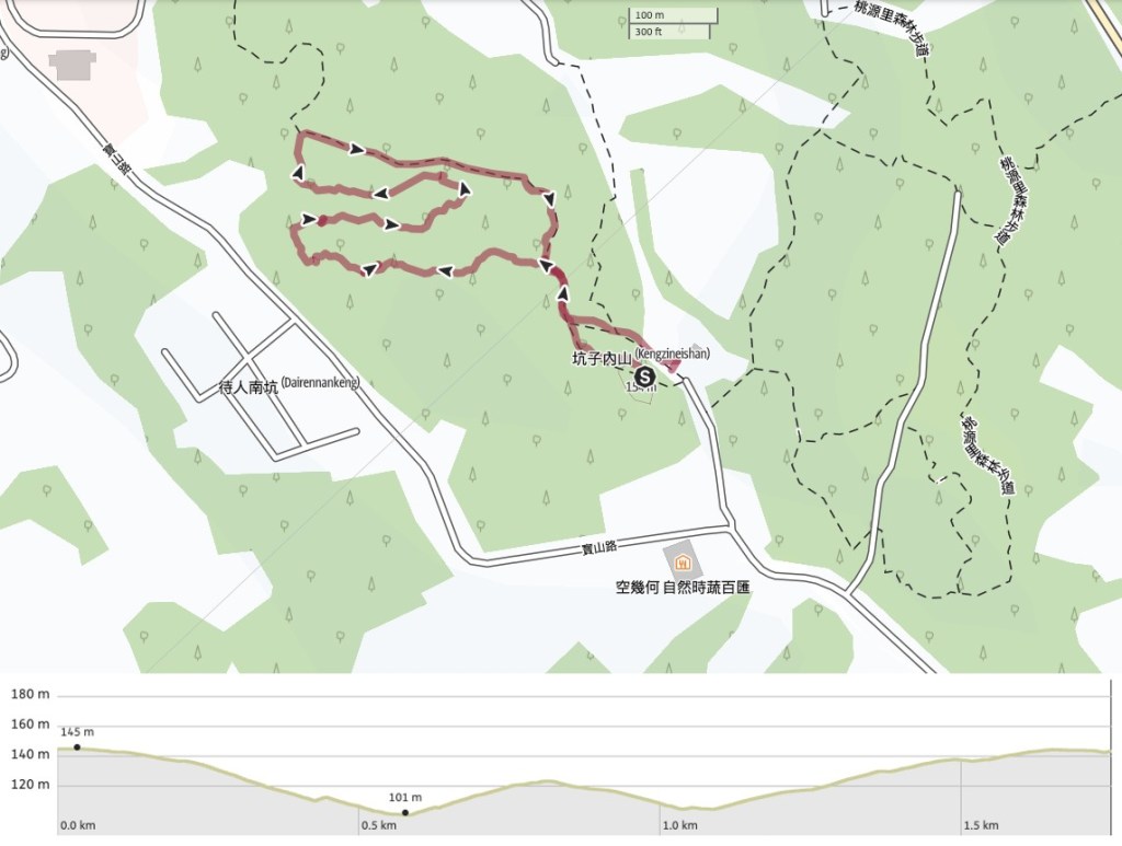
GPX file available here. The trails here aren’t all signposted, they don’t all appear on the online maps, and the trail maps are only a partially accurate depiction of what you’ll find, but the trail is bordered by roads on all sides, so you can stomp around in the 1km2 patch relatively unafraid of getting lost.
This is the bit where I come to you cap in hand. If you’ve got all the way down this page, then I can only assume that you’re actually interested in the stuff I write about. If this is the case and you feel inclined to chip in a few dollars for transport and time then I would appreciate it immensely. You can find me on either Ko-fi or Buy Me a Coffee.

I’ve been following your blog since the past few weeks and I thoroughly enjoy your detailed posts of hiking trails across Taiwan. Living in Jakarta means I have to travel a little further to go hiking, but when I can’t at least your photos of those lush trees can cure my longing to be out in nature.
LikeLike