
Stretching about 30km from Changhua City all the way down to Ershui close to the border with Yunlin County, there runs a low mountain range that, when viewed on a map, has an unquestionably spermatozoidal shape. Numerous trails traverse the range, tracking up and down between Changhua on the range’s western edge and Nantou on the east. The trails here fall under the administration of the Tri-Mountain National Scenic Area–a unique kind of national park-esque thing made up of three non-contiguous hilly areas. We’ve wandered in this section of the Tri-Mountain National Scenic Area before, but this was our first visit to this particular trail.
A note on naming. I’ve tried to stick to English-only names for this Xiao Bai Yue trail guide series, but there are just some that sound weird. Heng Mountain does not sound appealing in English. So, Heng Shan it is.
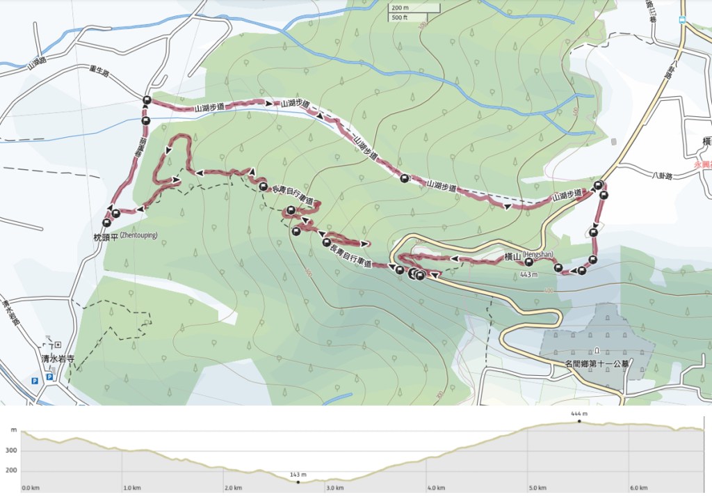
DISTANCE: 7.6km – There’s no way to make this any shorter, but it could definitely be extended by going up or down any of the many other trails instead of the narrowest little loop that we did.
TIME: 2½-3 hours – We went at a relaxed but steady pace, and only stopped for short breaks.
TOTAL ASCENT: About 320m to a high point of 443 metres above sea level.
DIFFICULTY (REGULAR TAIWAN HIKERS): 2/10 – A bit of a steep climb, and I did not like the trail surface on the way up.
DIFFICULTY (NEW TAIWAN HIKERS): 3/10 – The climbs and descents are steep but that’s literally the hardest part. It’s even pretty well signposted.
SIGNANGE: Surprisingly good. Top marks Changhua County for some clear, bilingual signage and trail maps.
FOOD AND WATER: I drank a little over 0.5L on a warm September day, Teresa a little less than me. Foodwise, we took snacks but didn’t eat them.
SHADE: Not consistent. I alternated between a hat and an umbrella to keep the sun off.
MOBILE NETWORK: Mostly ok, but with a few weak areas.
ENJOYMENT: This isn’t my favourite trail, but it’s a serviceable weekend leg stretch. It has a couple of views, some rural interest if that’s your cup of tea, and monkey-spotting potential.
SOLO HIKE-ABILITY: I wouldn’t worry about doing this solo. It’s easy, well trafficked and relatively close to habitation.
OTHER: Every walk I’ve done in this area has been full of thirsty mosquitoes, so go prepared.
TAIWAN 100 MINOR PEAKS: Number 48
ROUTE TYPE: Loop
PERMIT: None needed
Jump to the bottom of this post for a trail map and GPX file.

As with most of the trails along this stretch of mountain range, you can park either at the top or the bottom, so you have to decide whether you’d rather do your climbing at the start or at the end of your walk. We always do the tough part at the start when possible, so we parked at the bottom of the trail we would later walk down, and started our journey with a gentle warm-up of walking along a more or less flat road for almost 500 metres.


The single-lane track was busy with other walkers and a few locals on their scooters, and looking down in the direction of the far, far away coast, we could see the town of Shetou (社頭) under fluffy white clouds.

Keep an eye out for this turn-off on the right. It marks the start of Shanhu Trail (山湖步道) and it’s signposted as heading towards Shanhu Trail Exit.

Ahead of you lies around 1.8km of climbing. At first we found ourselves heading up through farmland given over to fruit trees.


We spotted longan trees, some custard apples, some pineapples, a few dragon fruit vines, and whatever that is in the last photo.

Ten minutes after leaving the road, we reached the end of the farmland and entered a slightly more shaded section of the walk.


The greenery beside the trail included a lot of giant elephant ear plants, grasses, and many stands of giant creaking bamboo. Teresa was getting hounded by mosquitos, so she couldn’t stop to cool down, but for some reason, they didn’t really bother with me… too smelly perhaps.

Please do not swim in the forest with the poisonous bees and venomous snakes.

About halfway up, there is a somewhat rickety-looking pavilion. I think Teresa would probably have liked a break, but with all the mosquitoes, she decided against it. I wasn’t too tired myself, but the loose rocks that made up the trail surface were starting to get on my nerves a bit.

When I say the bamboo is giant, I really mean it. The slender stalks towered above us, swaying and groaning in the first breaths of wind brought by an approaching storm.

As we approached the road, the path mercifully became paved again (I’m not normally a fan of concrete paths, but this was better than walking on potato-sized pebbles. Teresa also found this cute little mushroom on a stick which bears a striking resemblance to an opium pipe.


Where the trail hits the Bagua Road, take a left turn, follow the road as far as a little temple, (this is not far at all, only a minute or two), then turn off the road onto a narrow track on the right.
There are toilets by the temple for those who need them.

The track cuts through more farmland as it wends its way towards a campsite.

I’m not sure what the trees are that were growing in this field, but as with the rest of the crops, they were blessed with sticks of bamboo that had incense and spirit money wedged tightly into a slit at the top.


There were fields of tea bordered with the ubiquitous backdrop of skinny betel nut trees. This farmer had covered all of the ground between his rows of tea plants with peanut shells. I guess it’s either a type of compost or maybe the shells are a deterrent to some pest, but either way, this farmer had access to A LOT of peanut shells.

The next field along was full of be-skirted pineapples. After a little checking online, it seems that pineapples can get sunburnt, and the skirts will help protect them.


Beyond the pineapple, we encountered a field of tasty-looking bamboo, and beyond that, a hilltop campsite.

Next to the campsite, there is a space where you can look out over the Nantou side of the


In the immediate foreground is Nantou Electrical Substation. It’s not the prettiest sight in the daytime, but Google Maps has some photos of it in the fog looking rather spectacular. And somewhere behind that haze in the righthand photo is Taiwan’s highest peak: Jade Mountain. Evidently, it is visible on clear days.

After leaving the campsite behind, the track becomes a path, and we soon found ourselves at the triangulation marker for Heng Shan. At 443 metres above sea level, it’s the highest point along this range. (I think Teresa was just checking what, if anything, was inside the pole.)

The summit wasn’t particularly noteworthy, so we didn’t hang around. The trail leading down starts off as a flat path, but soon becomes steps, and as we were walking through this tree-lined tunnel, we enjoyed watching an adolescent monkey chasing a fully grown one down the slope, leaping and swinging its way from branch to branch.

As the trail draws close to Bagua Road for a second time, heads down a flight of steps that was absolutely swarming with tiny black ants. I wonder if maybe they could sense the approaching storm and were making their way to higher ground.


When we hit the road, we turned right onto it, walked about 100 metres, and then took the turnoff on the left.

This marks the start of Changqing Bikeway Trail. It seems really pretty rare to see this type of sign on Taiwan’s hiking trails. By and large, hiking trails are hiking trails, and biking trails… don’t exist. Well, there must be a few, but I couldn’t tell you where.

The first part is a little steep, but thereafter, it’s a gentle and sloping walk all the way down to the start.

We followed the paved route all the way down, but in one or two spots we noticed bike trails snaking through the greenery.


At the end of the bikeway, turn right and follow the lane all the way down to the road.

We soon found ourselves back at the junction where we’d parked and changed into clean clothes before heading off in search of food.
How to get to Heng Shan
Google maps address: We parked at the bottom end of the Changqing Bikeway. There’s space here for about ten cars and a lot of scooters, and we on a busy Sunday, we found space. If you can’t park though, there’s a lot more space at the nearby Qingshuiyan Temple.
GPS location:
- Changqing trailhead car park – N23 53.420 E120 36.945
- Shanhu trailhead – N23 53.670 E120 37.045
Public transport: Take the train to Tianzhong station then catch the 6915 bus bound for Yuanlin Bus Station. Ride it as far as Xucuoliao then walk an extra 15 minutes to the trailhead.
Further reading: There doesn’t seem to be anything else out there in English. In Chinese, you could look at this blog. They walked the same version of the route that we did, but they started at the top.
Nearby trails:
- Baguashan Wander
- Dengmiao Trail
- Longguomai Trail
- Sanqing Temple Eastern Loop
- Sanqing Temple Western Loop
My new words learnt on this hike:
- 這是一個鳥不生蛋的地方 / zhè shì yīgè niǎo bù shēng dàn dì dìfāng – This place is in the middle of nowhere. Literally, “It’s a place where birds don’t lay eggs”. It comes from a longer phrase 鳥不生蛋,烏龜不上岸, birds don’t lay eggs and turtles don’t go ashore. This is now my new favourite saying.
Heng Shan Trail Map
GPX file available here on Outdoor Active. (Account needed, but the free one works just fine.)
If you enjoy what I write and would like to help me pay for the cost of running this site or train tickets to the next trailhead, then feel free to throw a few dollars my way. You can find me on either PayPal or Buy Me a Coffee.
