(Updated: October 2023)
Distance: 6.6km to go there and back
Time: 3 hours – It could definitely be done quicker if you’re a fast walker though.
Difficulty: 2/10 – You can’t really get lost here since it’s a there-and-back kind of trail. There are slopes and steps but otherwise it’s quite simple.
Total ascent: 425m
Water: 0.5L was enough on a warm autumn day – we filled up at the temple at the far end of the trail.
Shade: Patchy, I might have needed more protection if I’d come in the summer.
Mobile network: No problem
Enjoyment: 6/10 – This is a perfectly pleasant afternoon stroll with a few military curiosities and different scenery to what you get around Taipei.
Bathroom facilities: There’s a grimy portaloo close to the trailhead at the start and a more comfortable toilet block at the temple at the far end (or middle) of the route.
Other: There’s a cafe and a coffee shop next to each other where you can stop for tea, coffee or pizza along the way. There are also water dispensers at both ends of the trail.
Jump to the bottom of this post for a trail map, GPX file, and transportation information.


The last time I came with Teresa, we parked up in front of Tiande Temple (天德宮). Some people (especially those travelling by scooter) park right at the trailhead, but it’s just a minute or two further down the hill, so the large temple carpark is as good a place as any to stop. There’s also a café here which only opens at 4pm (and doesn’t close until 1am), where you can sit with a drink and some snacks to watch the sun set and enjoy the night scenery of Hsinchu.

The trailhead is marked by some benches, a big sign naming the trail (both of which are pretty standard trailhead decorations), and a tank (which is decidedly less standard). On the weekend, there are also several vendors selling tofu pudding and vegetables.

The walk begins as it continues. Lots of not-too-steep ups and downs and a well-kept (if uneven) path.


Ignore a dirt trail leading away to the left and keep climbing up to a wooden pavilion. Here, you’ll find an incongruous water dispenser (there’s another at the far end of the trail). It seems like a Hsinchu thing to provide water on trails like this, because the only other trail where I recall coming across water dispensers actually on the path is on the 18 Peaks Mountain Trail.

Shortly after the peak, I ignored another trail on the left.

This is basically the general vibe you can expect from this trail. A little way beyond this I started to hear the sounds of a crowd of kids getting riled up by someone with a loudspeaker.


After another turn-off on the right, the trail tackles another small hill, but before long, I was back on the (almost) flat again.

About 20 minutes after starting the walk, I arrived at a hill top exercise area/adventure playground. On weekends, I’m sure this is absolutely full of visitors.

Two paths lead down from the far side of this clearing. I stayed on the main trail and took the righthand path.

Continuing on, the trail passes another of its military relics: an old bunker. The entrance is painted with splotchy camouflage colours and inside the structure remains clean and empty.

On my first visit, we went inside. In one corner, there is an ominous tunnel which runs back away and then curves. We had a little exploration, but I’m a bit of a chicken really so I didn’t feel like poking around too much.

There are occasional glimpses of Hsinchu and distant mountains to be snatched through gaps in the trees to the left.

Another tunnel entrance. This one has been blocked off to prevent intrepid explorers.

Not far up from the bunkers, there is a cleared area which had been decked out with all manner of swinging things, hanging ropes, one seat so wide that it could almost be a two-person swing, hoops and bars for the more acrobatically inclined. This spot has changed significantly in the almost six years between my two visits. It’s now far more shady than it used to be on account of all the extra tree cover.

Walking on from the swings, the path arrives as a somewhat incongruously placed coffee and pizza shop. The path splits here, and I decided to veer away from the main trail to take the path on the right which cuts its way up through some of the café’s outdoor seating areas. It’s signposted in Chinese as heading towards Lianhua Temple (蓮花寺).


Once you’ve zigzagged your way up through all of the roped-off café areas, you’ll find yourself walking along a fence and passing another bunker.

Then another ten minutes after leaving the main trail, you rejoin it at a little rest area. Take a right turn onto the main path here.

A pavilion beside the trail just before it starts to make its way down to the temple.

Take a right turn towards the temple carpark here. You’ll pass another water dispenser before you reach the end of the trail and there is a bathroom block on the far side of the temple.

The temple houses many gods. On the main altar you’ll find Guanyin, and to either side of her are Dizhang Wang (the Buddha responsible for making sure hell is devoid of souls), and Shennong in his leaf pereline and skirt. I’m not sure if one should admit to having a favourite deity, but I have to say, I have a bit of a soft spot for Shennong.


There were people meditating and praying in the main hall, so I didn’t take any photos inside, but I did spot these guys hanging out next to the spirit money furnace.

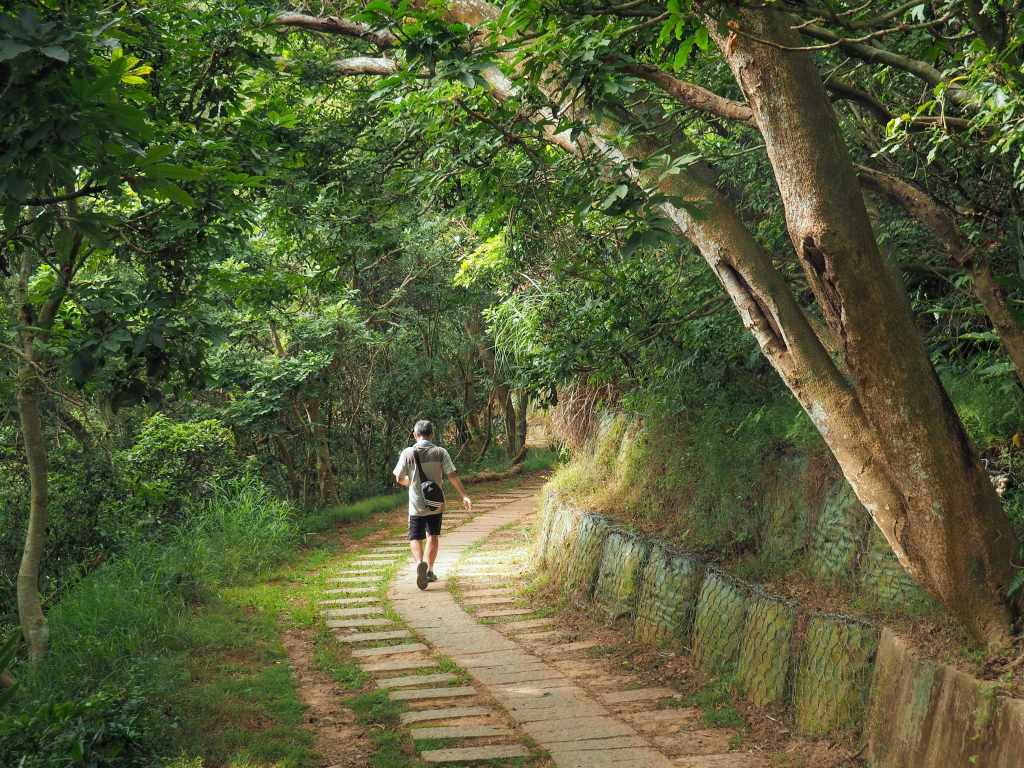
Now, my original post stopped here. I declared that this is a there-and-back walk so there’s no need to detail the return leg of the journey. That’s not exactly true. You can just walk back the same way you came, but you can also take a slightly different route for part of the way. I retraced my steps back up to the spot where I’d previously rejoined the main trail, but instead of heading up and left as this man is doing, I carried straight on.


The trail soon arrives at a small track (this is how the mountainside coffee shop gets its supplies deliveries). Cross over the track and continue up the trail on the far side.

This next little stretch is the steepest and least easy-going stretch of the whole walk.

You need to keep an eye on where you’re putting your feet in order to avoid being felled by the abundant tree roots.

But also, make sure to stop and enjoy the view through the trees. (That’s Mount Jiali over there.)


Just after passing another bunker, I reconnected with my earlier footsteps outside the hillside café.

For a short while, I retraced my steps, and enjoyed seeing the trail in a (literally different light). But this point, it was edging towards late afternoon and the sunlight slanting through the trees was a golden honey color.

Wanting to cover as much new ground as possible, I took this side trail on the right.

Just a short distance off the main path, I came across another (smaller) exercise area. This part of the trail network is a little bit of a maze, but in most cases, the trails all seem to connect up with themselves.


At this next junction, take a right, then after five minutes you can either go straight over or take another right.

I say you can do either because after just another minute or two, the straight and right trails merge into a single trail here.

The soil in this part of Taiwan is a dusty orange sand, so it looks even better in the beautiful late afternoon sun.

The trail climbs to what I think is probably the best sunset viewing spot along the whole route. (The view from the sunset viewing pavilion has been obscured by trees.) If I hadn’t needed to get back to Taipei, this would have been an excellent spot for a beer and a picnic.


Two paths lead away from the benches, one head up to join the main trail, and another one cuts over and slightly downhill. I took the downhill one and found myself passing through a shaft clearing that had been overrun by this (probably introduced) plant.

Again, you can go left and up or onwards and flat(ish) here, and again, I chose to take the flatter route, but they both rejoin at the top of these steps.


Likewise, heading straight (as I did) or down the steps on the right here both lead to the same spot. At the bottom of the steps in the second photo, bear left.

Once more, I took the righthand and flatter of the two trail options here. (Hoping that it would be downhill all the way to the exit.)

But of course, that was a very foolish think of me to think, because just before the walk concludes, it has a final uphill slog for you to enjoy.

I reached the road at a slightly different spot to where I’d entered the trail network, but if you head downhill from here, you’ll be back at the starting point within a couple of minutes.

How to get to Fengqi Sunset Trail
Google Maps address: The trailhead can be found close to Tiande Temple. Theres plenty of space in the temple carpark.
GPS location: N24 52.053 E120 58.721
Public transport: from Taipei you can take a local train as far as Xinfeng Station and rent a YouBike from outside the station. There is a second YouBike dock about ten minutes away from the trailhead.
Further reading: Enjoy Hsinchu has some basic information here.
My new words learnt on this hike:
- 風力發電 / fēnglì fādiàn / wind power, maybe also wind turbine since that was what I was told that it means but translate is disagreeing with the teacher on this one.
- 晚霞 / wǎnxiá / sunset
Fengqi Sunset Trail Map
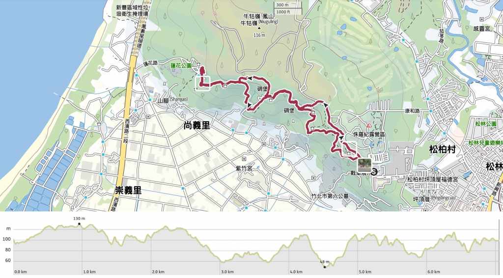
GPX file available here on Outdoor Active. (Account needed, but the free one works just fine.)
