Climbing Teapot Mountain, One of the North Coast’s Best-Known Hikes
(UPDATED OCTOBER 2023)
It’s been a good long while since we revisited this trail (years, in fact), but after plans to visit nearby Nanzilin Trail were thwarted due to construction work, we decided to come here to burn off some excess energy. It seemed like a good excuse to update a very old and tired post.
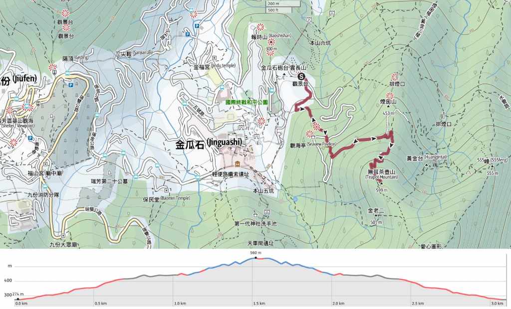
Distance: 3.6km
Time: 1½-2½ hours.
Difficulty (regular Taiwan hiker): 2/10 – Some scrambles, loose rocks and a little bit of scrambling at the end.
Difficulty (new Taiwan hiker): 3/10 – The steps are pretty steep, but it’s mostly paved, the signposts are well-maintained and easy to read. Right at the top you can do a bit of a scramble which would increase the difficulty but that’s not essential. There are countless tourists visiting this spot every day, so it’s doable, we did pass a couple of foreigners with bloody knees, so just be careful.
Total ascent: About 290 metres.
Water: A single small bottle should be enough. There’s a water dispenser at Quanji Temple where you can fill up if necessary.
Shade: There’s almost no shade, so if you go in the summer, you’ll need sun protection.
Mobile network: Coverage is clear throughout.
Enjoyment: The scenery here is really beautiful, mountains all folded in on themselves and a disturbance in the ocean where the river meets the salt water. However, the hike itself is very short. To get more out of your visit to Teapot Mountain, I suggest combining it with a trip to Mount Banping.
Seasonal: Between November and January the hills here are covered in elegant silvergrass.
Bathroom facilities: There are (unpleasant but usable) portaloos at two points along this trail.
Route type: This post details a there-and-back hike, but you can do a longer loop version if you include Mount Banping.
Permit: None needed.
Jump to the bottom of this post for a trail map and GPX file.

We started our walk from the carpark just above Quanji Temple. There are two ways to get to the start of the climb from here. You can either follow the road around the side of the hill, or take this tunnel cutting through the hill.


We opted for the tunnel. (Be careful if you take this route too, the floor is slippery.) The right-hand photo shows a Problepsis albidior moth resting on a leaf near the end of the tunnel.

The start of the climb is marked by some portaloos and a huge rock. If you take a minute to look at the hills from the fence at the far side of the road here, you should be able to spot the giant concrete flues belonging to the old Shuinandong Smelting Plant (now better known as The Remains of the Thirteen Levels). These giant tubes were previously used to transport the hideously toxic fumes created the copper smelting process up and over the hills-not so much dealing with the problem as displacing it.


The first part of the climb follows ugly concrete steps. At this first junction, take the left path to continue heading up, then a little while later, you’ll need to cross over a narrow road.

The trail climbs to a faded-looking pavilion (it was far brighter on our first visit).


Turn left and follow the road up as far as it goes. If you look down to the coast, you can see the small village that grew up around Shuinandong Smelting Plant. (After our walk, we headed down to a vegetarian café among these buildings for dinner.)

The road terminates here next to the entrances to a couple of old mine entrances. From this point, it’s just another several hundred metres up to the top.

The climb is a little harder than the earlier part on account of the fact that the trail is only surfaced in some areas. Where there are no steps, you’re walking on loose rocks and mud that require a bit of concentration.


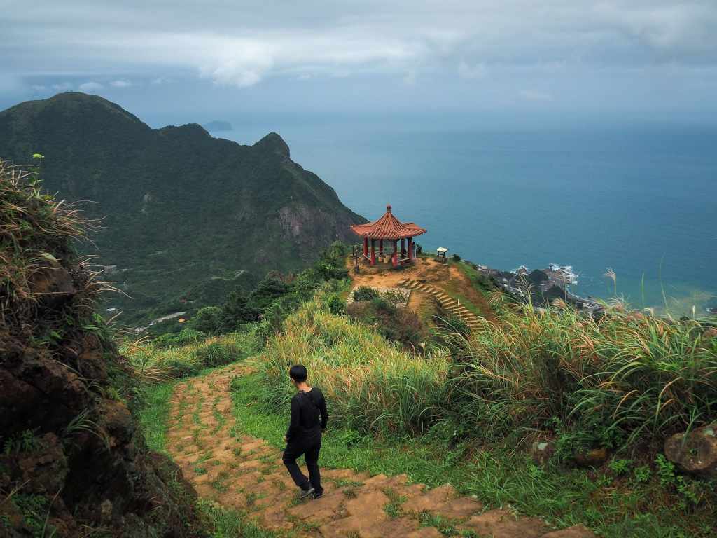
Further up, there are more steps that will take you as far as a second pavilion.

From the pavilion, you can see the whole of Jinguashi spread out over the slopes below, and beyond that patch of graves on the distant saddle, that’s Jiufen. The mound on the right is the unmistakable Mount Keelung, rising (according to its nickname, 大肚美人山), like a beautiful pregnant belly.


Looking southeast, you can see the folded hills leading up to Mount Canguangliao, with many trails and quarry scars cutting across the greenery. One feature that stands out is the old Shinto temple above Jinguashi Gold Museum. If you have time (and energy) later on, it’s worth detouring back down through the museum’s grounds to take a look.


Make sure to look back as you climb towards the final rocky knob of Teapot Mountain-this is where you’ll find that classic view of the red-roofed pavilion rising above the blue ocean. And then in front of you, there is just one final push to reach the summit of Teapot Mountain.

On our most recent visit, we contented ourselves with admiring the teapot from a distance, but if you want to, you can wriggle up through a hole to get above it. There are fixed ropes to guide you through and assist with pulling yourself up, but if you suffer from claustrophobia, you’ll probably want to give this one a miss. (This goes doubly so for weekends, when people don’t seem to be capable of letting one person pass through at a time.)

The views from the top are undoubtedly beautiful, but not a whole lot different from what you can enjoy lower down.
Getting to Teapot Mountain
Google Maps address: The walk starts and ends at the carpark behind Quanji Temple. It used to be free, but now its $100 for cars on weekdays, $150 on weekends, and maybe $20 for scooters.
GPS location: N25 06.695 E121 51.701
Public transport: There are many ways to get to this trail, but by far the most direct for visitors starting in Taipei is to take the 1062 bus service from Zhongxiao Fuxing Station (leave the station via exit 2) and ride it all the way to Quanji Temple (which, I think is the terminal station). Personally, I dislike the pushy taxi drivers that you often get at Zhongxiao Fuxing, but if you ignore them, they’ll move on.
Nearby trails: There are so, so, so many trails in this area. I’ve done a few but I need to go back and explore a few more.
- Dacukeng Historic Trail
- Mount Keelung
- Jinguashi Aqueduct Trail
- Mount Banping (a longer walk which includes Teapot Mountain)
- Stegosaurus Ridge
- Tamsui-Kavalan Trails – Ruifang to Fulong
- Tamsui-Kavalan Trails – Ruifang to Shuangxi
- Tamsui-Kavalan Trails – Mudan Loop
Teapot Mountain Trail Map
GPX file available here on Outdoor Active. (Account needed, but the free one works just fine.)
My new words learnt on this hike:
- 茶壺 / chá hú / teapot
- 煤礦 / méi kuàng / coal mine
If you enjoy what I write and would like to help me pay for the cost of running this site or train tickets to the next trailhead, then feel free to throw a few dollars my way. You can find me on either PayPal or Buy Me a Coffee.

the last touristy thing I did before I left! ❤
LikeLike
It is definitely one of the touristy walks worth doing, the views are wonderful.
LikeLike
hi,
i chanced upon your blog when i was solo traveling in tw 2 months ago and found it extremely helpful. i am an avid hiker and i especially love how you categorises the hikes and the very detailed break down points on things to look out for. this is god’s send of a site. absolutely loved it. keep hiking, keep blogging.
love from singapore.
LikeLike
Thank you very much for your kind words of encouragement. It always makes me incredibly happy to hear that someone has found this blog helpful when exploring Taiwan’s mountains, so I really appreciate you taking the time to reply to me.
LikeLike