Ambuping Hiking Trail (also called Maifuping Trail on the signage in the village) is a short loop in the lower elevation part of Taichung’s Heping District. The trail encircles the Tayal tribal village of Shuangqi (雙崎 or M’ihu in the Tayal language) and takes in one peak, a section of ridgeline, and the remains of an old irrigation canal.
Distance: 3.6 kilometres.
Time: 1½ – 2 hours should be enough.
Total ascent: About 240 metres.
Difficulty (regular Taiwan hiker): 3/10 — There are some steep ascents and descents, but they’re assisted by steps and railings, so this is nothing more than a bit of a workout for those familiar with Taiwan’s trails.
Difficulty (new Taiwan hiker): 5/10 — For those new to hiking in Taiwan, the steep climbs and general trail conditions would make this a moderately difficult hike.
Risks and dangers: There are a few spots where you’ll encounter a steep drop to one side of the trail, but anyone of reasonable surefootedness will be fine. There are also guard dogs in the lemon grove at the far end of the trail, but they were noisy rather than genuinely aggressive.
Water: I took 0.5L and drank only a little of it on a cool winter day. There is a small convenience store in the village close to the elementary school where you can stock up on provisions, and if you want to fill your water bottle, you can always ask at the police station.
Shade: The on-trail portion of this walk is well-shaded, but you’ll be exposed when you’re walking back up the road to the start.
Mobile network: Phone coverage was clear throughout.
Enjoyment: This is a neat little loop. It’s nothing mind-blowing, but if you’re passing through the area and want to stretch your legs, this walk is definitely worth the couple of hours you’ll spend on it.
Bathroom facilities: There is a toilet block at the southeastern end of Shuangqi’s main street.
Route type: Loop
Permit: None needed.
Jump to the bottom of this post for a trail map and GPX file.

The carpark lining Shunagqi’s main street offered us the first view of the walk. From this higher vantage point, we could see gravel trucks trundling up and down a track beside Da’an River, kicking up long dust trails as they passed.

Turning our backs on the river, we made our way through the narrow lanes following signs directing us variously to Ziyou Borough Office, a century-old Zelkova tree, and a scenic outlook.

There are many routes through the village that will get you to the trailhead, but whichever you pick, you’ll eventually end up here, walking through orchards towards a farmhouse guarded by a dog whose name we later learnt was 黑寶 — Black Baby.


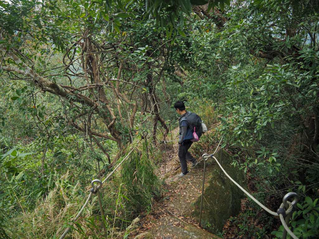
Just as we drew near the farm, a sigh directed us to the left and we began the trail portion of the walk. On the slopes beside the path, we watched a woman wrangling a hose amid her fruit trees.

As we’d been making our way up the first short section of path, a convoy of scooter riders was winding its way up through the orchards to an access point a little further up. We reached the access point at the same time as the scooters and encountered a quartet of Indigenous guys embarking on the same climb accompanied by Black Baby. At first, I mistakenly assumed they were hunters, but after a brief conversation, it transpired they were working on improving the trail facilities.

The climb was steep and alternated between wooden steps and steps carved directly into the rock surface.

At the top of the steps, we caught up with the work crew. They’d paused to smoke before cracking on with whatever it was they were working on and told us to be careful as we turned left to go in search of Mount Ambuping.

The summit trail is a brief detour from the main loop — it’s a little over 100 metres along a wooded ridge from the junction to the hilltop clearing.

At present, there is little more than a triangulation stone to mark the clearing, but a series of notes scrawled on sawn-off chunks of wood indicated that the workers have been contracted to install benches and a more elaborate marker. After reaching the summit, we retraced our steps to the junction at the top of the steps.

Passing straight over, we soon found ourselves standing in front of the century-old Japanese zelkova that the signs were directing us to. A sign beside it explained that the Tayal name for this species is “tgvin” and that the wood was prized for its hard, decay-resistant qualities. Villagers would use the trunk and bigger branches to build their houses and with what remained, they would always fashion a millet-pounding mortar and pestle (one of those huge ones like the one that can be seen on the village’s main street). In the past, zelkova trees were common along the banks of the Da’an River, but as the information board so poetically puts it, “the appetites of mankind, once more have proven the murderers of nature.”

For 15-20 minutes, we ambled along the ridgeline. The trail was narrow, but well-defined and easy enough to follow. At one point, we startled a muntjac deer, sending it skittering off down the slopes.

As recently as a year or two ago, it was possible to get a clear view of the village, but it seems that the trees have been busy growing.


After reaching the spot with a view of the village, the trail starts its descent. Then, at the bottom of a flight of wooden steps, it suddenly and unexpectedly levels off to follow the route of an old irrigation canal.

There used to be two irrigation canals serving Shuangqi Tribal Village, both constructed during the period of Japanese occupation as part of efforts to get Indigenous villagers to produce rice (something similar was done with Ma’an Irrigation Canal up near Wulai). The old canal followed by this trail was wiped out by Typhoon Gloria in 1963, and now there’s little to tell of its presence, save for this tunnel that was cut through the rock to allow water to pass through.

The tunnel is maybe 5-7 metres long and it’s possible to pass through if you duck down. However, the trail doesn’t pass through here and there’s nothing much on the far side though, so if you’re not too fussed about small, dark spaces, there’s no need to force yourself to enter it.

From the tunnel, it was a short walk down some steps to the end of the trail. From here, we followed a winding track down through a lemon grove that was guarded by a family of noisy black dogs.

And the building at the bottom of the track where we rejoined the road was “guarded” by this adorable ball of fluff. She could not contain her excitement as she ran over to see us — her whole rear wiggling in anticipation of some fussing. Of course, Teresa did not need any further encouragement and the two were soon firm friends.

When you hit the road, it’s a simple case of taking a right turn and following the road back uphill and into the village.
How to get to Shuangqi
Google Maps address: The walk starts and ends from Shuangqi’s main street. There is a small amount of parking available here, but it shouldn’t be hard to find somewhere to park if you come by car or scooter.
GPS location: N24 17.370 E120 54.615
Public transport: The 253 service runs between Shuangqi Village and Dongshi Bus Station about six times a day with the last bus departing from in front of the school around 6pm (although since this is a rural service, it may come 20 minutes earlier than expected). Lots of buses (90, 206, 207, 208) shuttle backwards and forwards between Dongshi Bus Station and Fengyuan Transfer Station.
Nearby trails:
- Raknus Selu – Day 13
- Raknus Selu – Day 14
Shuangqi Ambuping Trail Map
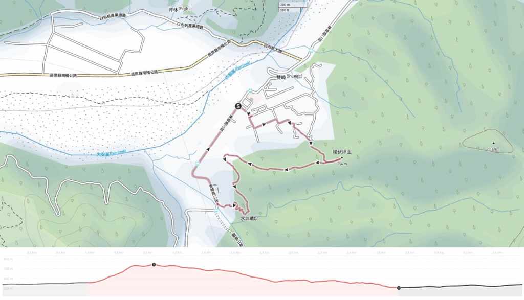
GPX file available here on Outdoor Active. (Account needed, but the free one works just fine.)

thankyou for your kind guidance.
LikeLike