This lesser-known walk in New Taipei’s Ruifang Distrist is a fun half-day adventure for anyone seeking something a little more off-the-beaten track. Starting from Nanya Rocks, the trail climbs steeply to Nanya Mountain (南雅) before looping back through dense forest to pass a unique geographical feature known as the Front Teeth Rocks (門牙岩). You can expect short scrambles and coastal scenery, as well as a squeeze through a tight gap below a rock wall.
Distance: 4.6km
Time: 3½-4½ hours – We spent about 4 hours walking this at a very laid-back pace.
Difficulty (regular Taiwan hiker): 5/10 – This is a moderately difficult walk for those accustomed to Taiwan’s hiking trails. It is steep, slippery and there are lots of sections with ropes. There are also quite a lot of interconnecting trails, all of which have only the most basic hand-written signs.
Difficulty (new Taiwan hiker): 7/10 – This should be considered a challenging hike for anyone new to hiking in Taiwan.
Total ascent: About 250 metres.
Water: I drank about 0.6L on a cool winter’s day. We didn’t take snacks, but it would be nice to take it slow and have a little lunch break. You will need to bring your supplies with you.
Shade: Most of the trail was quite well-shaded, but walking back along the road is entirely exposed.
Mobile network: Phone signal was pretty clear for the most part.
Enjoyment: Considering how entirely unknown this walk is, it’s a very satisfying mini adventure. There are some cool coastal views, some fun climbing, and some neat rock formations. It’s also a great length—neither too long nor too short.
Other: Gloves are essential for protecting your hand from all the ropes. And long trousers and sleeves are highly recommended to protect yourself from the undergrowth.
Bathroom facilities: If you arrive by bus, there’s a public toilet by the Nanya Temple bus stop, otherwise, there aren’t any facilities along the way.
Route type: Loop or point-to-point, depending on whether you’re driving or using public transport.
Permit: None needed.
Jump to the bottom of this post for a trail map and GPX file.


The trail starts, very handily, right from the rear end of Nanya Rocks Car Park. A sign by the entrance to the trail indicates that the area beyond should not be entered, but I believe that pertains to the watercourse, not the area we hiked.

You couldn’t ask for a more promising view to kick off the adventure.

Before you reach the concrete bridge in this photo, look out for the clutch of hiking tags leading you steeply uphill to the left. The trail heads over exposed rock, so it’s not easy to spot. In fact, we overshot at first and ended up backtracking.

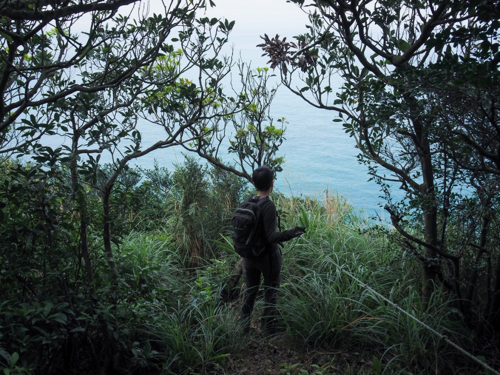
After an initial climb up the exposed rock face, we edged left around a boulder and found ourselves heading into the cover of the trees. From this point onwards, the trail mostly saw us travelling through quiet forests with occasional views over the coast.

The first such view gave us a glimpse back over where we’d just begun our climb. (The car park is just obscured by greenery at the bottom of the frame.

This brief and exhilarating stretch saw us climbing on a semi-exposed rocky spine. The trees to the right of the path were taller than us, but on the left, just a waist-high strip of greenery separated us from a sheer drop.

One of the more knarly and/or gnarly rope sections.

The trail reaches a T-junction. We turned right, but the left trail also loops back to rejoin the path we were on after a short distance.


At the top of a short, steep scramble, the trail reaches another T-junction and we turned right once more. (The trail on the left is the rejoining trail from earlier.)

The next 15-20 minutes followed a gently meandering trail through pretty dense trees. The forest floor was absolutely riddled with pangolin holes and evidence of either wild boar or deer rooting around for something or other.
Mount Nanya’s western peak sits on a junction, and from here we took a sharp left turn following signs towards Mount Nanya.


The path dipped and climbed in small increments through a green tunnel that was full of the melodious (if repetitive) call of a Taiwan barbet and the raucous replying cackles of a huge flock of grey treepies.

Soon we arrived at another junction. Straight on for a minute to Mount Nanya or right to the Front Teeth Rocks.

We took the brief detour to visit the peak of Mount Nanya, which was in truth, no more than 10 metres away from the clearing. From here, we could see Keelung Islet just out to see, the perfect onigiri shaped form of Mount Keelung, and the thrilling spine of Stegosaurus Ridge climbing to the oddly clipped Mount Banping.
After taking a look, we returned to the junction to take the other path leading onwards and down towards the Front Teeth Rocks.

Despite it being a national holiday, many of Teresa’s customers (design and construction companies)

A standing rock that looked much more impressive in the flesh than it does in a photo.

This was our second glimpse of the Front Teeth Rocks. (The first was further back right near the start of the walk.) From here, the path tracks around the ridge to the right of the rocks.

Another three-way junction. At first we made the mistake of turning left here, while it does meet up with the same trail later on, it wasn’t the route we wanted to take. Instead, take the path climbing up from here. If you’ve been paying attention to the landscape and have a good sense of direction, this path will be the one that feels like it should be heading towards the Front Teeth Rocks.
*This is where you need to return to if you don’t fancy squeezing through the gap.


About ten metres up from the previous junction, there is another. Take a left here and keep climbing. Then, after ten more metres, there’s a yet another junction. Heading straight will soon bring you face to face with the Front Teeth Rocks, while the righthand trail is signposted as heading to the Gap Tooth Hole (蛀牙洞, I usually prefer to just use the pinyin spellings of place names that don’t have an official English translation, but Gap Tooth Hole is far more evocative than Zhuyadong).

From this angle, it feels tantalisingly like you should be able to jump from one rock to the next, but I wouldn’t recommend trying. Instead, we turned back to take the junction leading to Gap Tooth Hole.

The path—which wasn’t shown on the map I was using—headed steeply down for a couple of minutes before looping back around to reach the bottom of the rock face, and we soon found ourselves standing right below the two protruding teeth.

To continue the walk from here, we had to get on all fours and scramble through the gap. If you don’t like the sound of this, then instead of taking the Gap Tooth Hole route, you can return to the junction where we made a mistake.*
On the far side, the path merges with a trail coming around the other side of the rocky ridge, and we turned right onto it.

A little further along, we reached another junctuion. Here, the trail that will take you back down to the road is on the left, but first, it’s worth taking the righthand trail heading up so that you can enjoy the best views of the Front Teeth Rocks.

We had not seen or heard a single soul on the whole trail up to this point, but unfortunately for us, our arrival at the walk’s “destination view” coincided with the arrival of an Instagram couple. The arrived literally 30 seconds before us and the girl partially disrobed before the pair of them embarked on their photo session with an audio backdrop of shitty pop blaring from equally shitty speakers. They did have the grace to ask us whether we would like to take photos first (because they would be photographing and then flying a drone). However, the whole conversation had to be shouted on account of their crappy music. I get it that some people like to listen to music on the trails, and on unpopular trails like this, where you’re unlikely to bother people, why not? (That’s a rhetorical question.) But a little consideration wouldn’t go amiss, and if you meet people—especially if you’re the only people for miles around and are stopped in the same place—just turn it off.

Hurried photo taken, we beat a retreat and I was glad to hear the sound of their music get snatched away from us by the light breeze.


By the time we were retracing our steps, the top of Mount Keelung had been bitten off by low-hanging clouds.

Back at the previous junction, we took a sharp right to begin our descent to the coast.


Luckily for us, our music-toting friends had come up this way cleared the route of spiders’ webs. It felt quite spectacular to cut along the hill’s exposed shoulder with nothing but the sea beyond.

By this point, we could see and hear the traffic on the coastal road below us. Looking over to the distant rockface, I spotted a ladder leading up to an opening with what looked to be several urns.

About five minutes from the trailhead, we passed the remains of an old house (or maybe houses). The remains of rock walls were so overgrown with plants that it was very hard to see what the structure’s footprint would have been.


The final descent was surprisingly overgrown with tall (sharp) grasses.

Then right as we neared the road, I spotted the same cave I’d seen earlier, only from this distance, the cremation urns were unmistakable. Perhaps this is the final resting place of the people who used to live in the stone house. Or perhaps they hold the remains of fishermen pulled from the sea.


Turning left onto the road, we headed back against the steady flow of traffic to where we’d parked. I absolutely hate walking along this road because it’s full of speeding trucks, but thankfully, we arrived back in one piece.

How to get to Nanya Front Tooth Rocks
Google Maps address: The walk starts from the Nanya Rocks Car Park. There’s plenty of space for cars and scooters.
GPS location: N25 07.150 E121 53.575
Public transport:
- Getting to the start – Take the train to Ruifang then walk a few minutes to catch the 886 Tourist Shuttle service from Ruifang Train Station (District Square). Alight at Nanya (Nanxin Temple). Continue walking along the road until you reach the Nanya Rocks Car Parks.
- Getting back from the end – You can either walk back along the road to the starting point, or continue walking along the road to Bitou bus stop and get the bus back from there instead.
Further reading: There isn’t currently anything else in English out there, but there are a couple of Chinese posts like this one.
Nearby trails:
Nanya Front Tooth Rocks Trail Map

GPX file available here on Outdoor Active. (Account needed, but the free one works just fine.)

thank you so much for providing this resource it’s literally been invaluable to me! following your guides i did pingxi crags sandiaoling and this hike. planning to do huangdidian in a few days with a friend. i’ve read more posts than i can count for some fun hiking while i’m in taipei for a few days and these exceeded my expectations. met a hiking group near the peak today and they seemed surprised i even managed to find the existence of this hike as an out of towner 🙂
LikeLiked by 1 person
That’s great to hear! It’s always lovely to get positive feedback like this. I wish you a safe and fun trip up Huangdidian with your friend — make sure you take plenty of water, salt candy and sun protection, it’s going to be hot!
LikeLike