
Hiking the Dakeng Trails in Taichung
The low-elevation hills just east of Taichung are chock-full of trails just waiting to be explored. In particular, Dakeng–the area between Fengyuan and Taiping District–is known for being a hiker’s playground. There are ten routes that are collectively named “the Dakeng Trails”, some of which feature photogenic log paths. This post covers trails number 9-1 and 10.
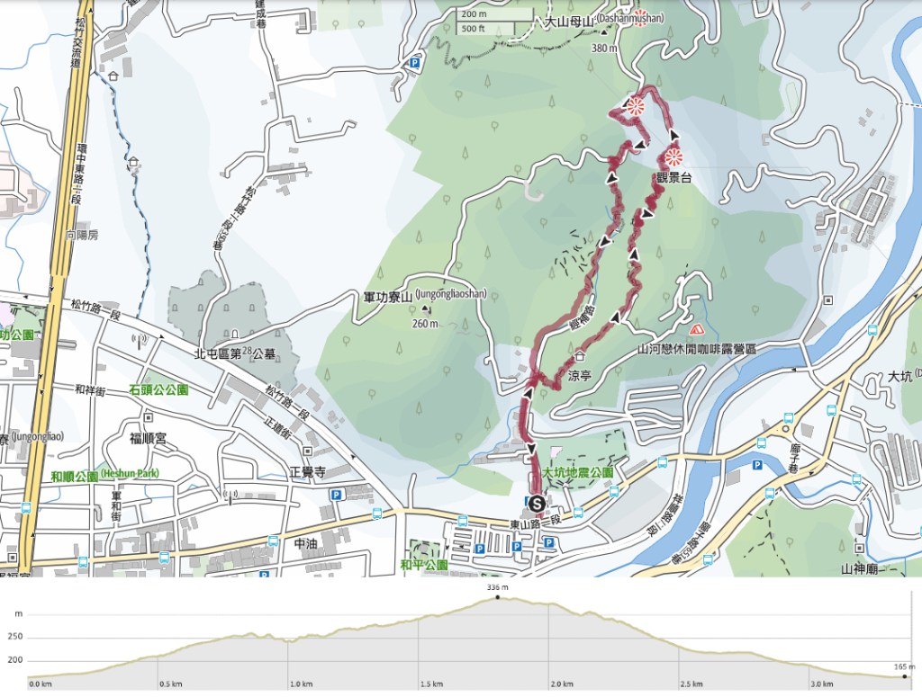
Distance: 3.4km – Since this route connects with trails six, seven and eight, there are lots of ways you could extend your journey if you want to.
Time: 1½-2 hours. I wasn’t in a rush and it took me about an hour and forty minutes.
Difficulty (regular Taiwan hiker): 1.5-2/10 – Just some steep steps. On a hot day it would be tiring, but not difficult.
Difficulty (new Taiwan hiker): 3-4/10 – I’ve heard plenty of new Taiwan hikers lamenting this type of stairmaster trail, but aside from the endless steps, it’s very easy. The signs are clear and the trail conditions are good.
Total ascent: Just 170m, but it feels a little more.
Water: A small bottle should be more than enough. There are stores close to the trailhead but I didn’t see anywhere to fill up a water bottle.
Shade: The shade was patchy, I had an umbrella that I ended up using most of the time.
Mobile network: Clear throughout.
Enjoyment: This seems to be an extremely popular exercise route among local walkers and I can see why. The paths are well-kept, the forested trails are pretty, and you can stop to enjoy the view at several points too. It’s not as cool as the log steps, but if you’re in the area and want a bit of exercise, why not pay a visit.
Route type: Loop
Permit: None needed
Jump to the bottom of this post for a trail map and GPX file.


Getting to the start of this walk is simplified by the fact that the city authorities have helpfully decided to name the closest bus stop Dakeng No.9 Trail. As a hiking fan, I appreciate this and propose that all future new bus stops be named after the closest hiking trail. Walk up the road from the bus stop, cross over and take a left turn onto Jingbu Road (經補路). It is almost impossible to miss the start of this walk on account of the massive volume of humanity milling around the market by the trailhead. Even late on a weekday morning, the farmer’s market was full of walkers and shoppers. I imagine it is heaving on a weekend.

The walls beside the trail underwent beautification at some point in the distant past. Murals depict some of the local flora and fauna with varying degrees of flaky paint.

The start of the trail is easy to miss, crowded as it is by more vendors. Just keep your eye open for a trail map and some steps on the right side of the road.


The start of the trail is a very good indicator of what you can expect the whole way: well-maintained wooden steps and walkways.

The wooden posts were home to a large number of geckos, spiders, caterpillars and other creepy crawlies. This one tried (unsuccessfully) to trick me into believing it was invisible.


The steps are really very steep in some places. So steep in fact, that if you’re not paying attention, it would be possible to overbalance.
Thankfully, all that climbing is interspersed with flatter sections and little rest areas with benches. From this ridge-top walkway, it’s very easy to make out the ten-metre-high statues of Buddha atop the nearby South Guanyin Mountain (one of Taiwan’s 100 Minor Peaks).


The trail joins a road and climbs past a little coffee shop with outdoor seating. Just keep sticking close to the steps until the road ends and you find yourself descending into the trees once more.

The path appears to split in two, but in fact, the trails reconnect just a little further along, so take whichever appeals to you the most.


The trail is pleasant and shady, and the trees are filled with talkative birdlife. In this area, I saw light-vented bulbuls, grey treepies, Taiwan barbets and Japanese white-eyes–basically a who’s who of low-elevation birdlife.

Some more of those thigh-buster steep steps.


I enjoyed the fact that this trail manages to give you a variety of scenery to enjoy. There are patches of shady forest, and spots with city views too.

At the top of the steps, the path takes a left turn. (You come up those steps on the left in this photo, then head straight along the track.)

Before I headed that way though, I took a ten-metre detour to climb an observation platform. From the main platform, a playful rope bridge joins a raised walkway encircling a tree. It’s an entirely unnecessary detail, but a fun one.

From the platform you can look over towards a second platform at the star of trail number nine.


The road climbs for a hundred metres or so before arriving at a junction. Head left towards the map and look out for the entrance to the viewing platform.

This one has better views than the previous one. That sharpish peak just right of the pylon’s head is Mount Dahengping Shan–the only one of the visible peaks that I know I’ve climbed.

There were a couple of vendors selling drinks and some snacks around the junction, so I assume you would have even more choice if you visited on a weekend. I’d brought everything I needed with me though, so I headed towards the entrance of trail number nine to start my descent.


The steps heading down are much the same as the ones on the way up had been. The only difference being that there are more signs of farming in this area. The little vignette on the right interested me because there were both bananas and papayas growing seemingly on the same plant (obviously they weren’t, but it looked that way at first glance).

More stalls can be found at the bottom of the first flight of steps, where route number nine becomes a track. One of these sells tea eggs, the other has coffee and grass jelly. There was also a farmer selling fruit and vegetables off the back of a truck. It doesn’t seem like the best place to do a roaring trade, but I guess if you want to enjoy the atmosphere, it might not be a bad job.

Another viewing platform marks the point at which trail number 9-1 splits from the main trail number nine.


There are a few of these wooden wedges for stretching out right calf muscles. Even better, you can enjoy a view of the city as you do your stretches.

I chose to head down the steps of trail number 9-1, but it would also be possible to walk down trail number nine (which I assume follows the single-lane road all the way down). The short remainder of the trail is more of the same pretty wooden pathways.


Then before I knew it, I had arrived at the bottom and was walking through the very top end of the market back towards where I’d started. The stalls up here weren’t open on a weekday, maybe they’re weekend only.

Some pretty toilets I passed at the bottom of the trail. Once I got back to the main road, I went in search of some sustenance to keep me powered up for the journey home.
How to get to Dakeng Trails 10 and 9-1
Google Maps address: The walk starts and ends at Dakeng Farmer’s market on Jingbu Road. There’s a carpark here and another bigger one a little away and across the road.
GPS location: N24 10.800 E120 44.015
Public transport:
- From Taichung HSR Station – Take the Taichung MRT as far as Sihwei Elementary School. Walk to Li An Hospital bus stop then catch a bus to Dakeng Trail No.10 bus stop. Multiple buses go this way, you can hop on the 1, 15, 21 or 270 via Danan.
- From Taichung TRA Station – Walk to the Taichung Station (Dazhi North Road) bus stop and hop on the number 20 bus towards Tanzi Station. Ride it for almost 50 minutes and alight at Dakeng Trail No.10. (This bus also stops at Jingwu and Taiyuan TRA stations, so if you’re travelling on a local train, you could alight at either of these.)
Nearby trails:
Dakeng Trails 10 and 9-1 Trail Map
GPX file available here on Outdoor Active. (Account needed, but the free one works just fine.)

I like your “stairmaster” description, it’s one I’ve never thought of.
And that description will be spot on for Dakeng Trail 4 … it’s log steps all the way.
Compared to regular flat wooden plank steps, the natural curvature of each log step means one has to be even more careful not to twist one’s ankle.
Will love to see what adjectives you’ll use after your fun on Trail 4. Cheerio.
LikeLiked by 1 person
Haha! “Stairmaster” seems to be the only suitable description for so many trails here. Although I found the less even surfaces on Trail 4 more enjoyable (if slower) to walk.
LikeLike