
A short stroll along Keelung’s coastal paths
Heping Island, along with its northern neighbour, Yehliu Geopark is one of those more touristy places that I somehow managed to avoid visiting for over six years. Now, I can finally say that I’ve been, I’ve seen, and I’ve wandered. (Although I’ll probably have to go back when it’s a bit warmer so that I can try out the seawater pool and walk along the section that’s closed during the colder months.)
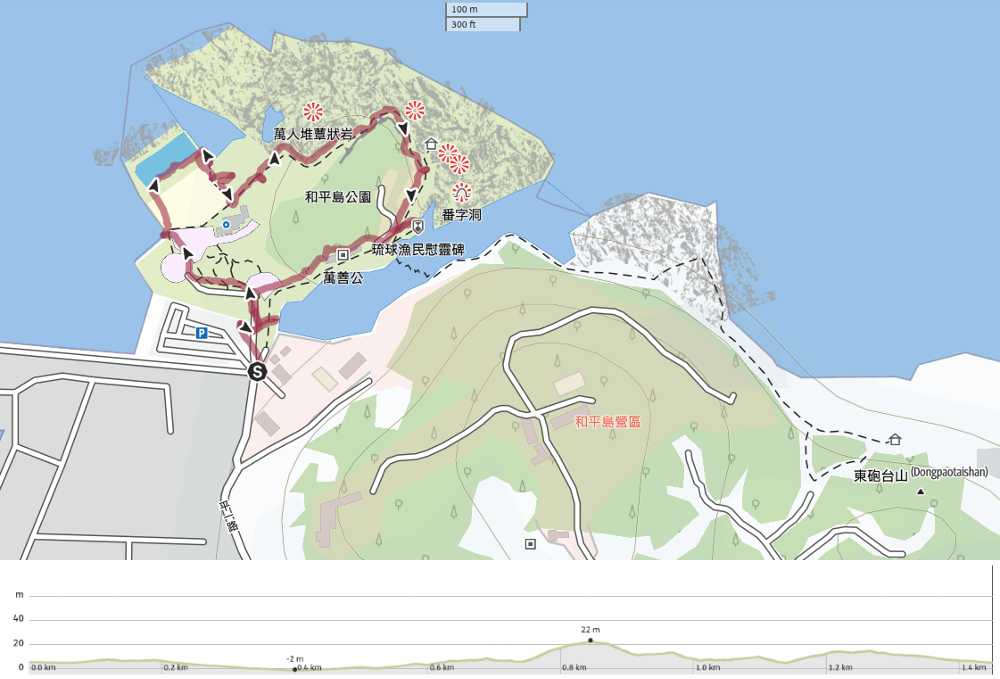
Distance: 1.4km – If you come in the summer and do the longer coastal walk, you will walk further.
Time: About an hour is enough for a quick loop. If you plan to swim, then make sure you give yourself more time.
Difficulty: 1/10 – This walk is easy for people of all abilities. There is a short section of steps, but the majority of the trails are either flat or sloped.
Total ascent: Just over 20 metres.
Water: A single small refillable bottle is enough. There are water dispensers at a couple of points around the park. (In the visitor centre and by the temple.)
Shade: There’s virtually no shade here, so make sure to bring cover if your skin needs it.
Mobile network: Clear throughout.
Enjoyment: This is a pleasant and gentle way to kill an afternoon if you’ve got nothing better to do. I would have enjoyed it even more had I gone in the water.
Other: If you plan to go swimming, make sure you also bring water shoes. The bottom of the pool is natural rock, so swimmers are prohibited from swimming without proper footwear.
Route type: Loop
Permit: None needed, but you do need to pay to enter the park.
Jump to the bottom of this post for a trail map and GPX file.


You can buy your tickets to enter the park from the little service windows beside the gate. If I’m honest $120 seems a little steep just to wander around the park, but if you’re planning on swimming and making use of the changing facilities, then it’s a little more reasonable.

The park’s running and upkeep was previously outsourced to some company, but in 2016, the local city government terminated their contract and transferred management over to the organisation that manages the North Coast and Guanyin Mountain National Scenic Area.

One of the first things to catch your attention when you walk through the gates is a viewing platform overlooking an inlet. We made our way over to take in the view, but our attention was caught by voices coming from below us, where a three-person team was using long-handled nets to haul in a tsunami of shitty single-use plastic. A sign on the platform asking visitors to question the origin of the rubbish and seek to produce less is a testament to the fact that it is an ongoing problem here.


I was curious to see the pools, so we started a clockwise loop by heading along the trail to the left. There was a team of gardeners using some rather heavy-duty digging equipment to lay new flowerbeds and their diggers looked like the diminutive offspring of the larger cranes.

A concrete ramp just before the visitor centre leads down to the waters.


There are three tidal swimming pools here. The first one you pass is a pet pool (although I am assuming it’s probably just a dog pool and no one is bringing their kitty out for a dip). The second is the main pool, and a little more inland there’s a kids’ pool. There was no one actually swimming when we passed through, but there were lifeguards on duty and I regretted not having brought my costume with me.

A pacific reef heron looking glum and moody as it struts through the shallows.

As we made our way towards the visitor center, this pair shuffled out onto the poolside and started limbering up as if in preparation for a dip.

We had a brief nosy around the visitor centre, but as is often the case, it was mostly just a load of junk for sale. A lot of the items were made of sustainable materials or recycled plastics, but somehow the entirely unwarranted consumerism of it seems a little naff when visitors only need to step outside and look at all the beached rubbish to realise that maybe we shouldn’t be buying so much stuff.


Leaving the visitor centre behind, we continued around the headland. At the far end of the visitor centre, there’s a sorry-looking would-be campground. A dozen or so car-less caravans have been arranged on a lawn, in what could be a quirky little spot to spend a night. Unfortunately though, the park management has not yet been able to get them to pass fire safety inspection, and so they’re just sat there unused for the time being.

Steps lead you up along the side of the hill with views over the water to Keelung Island. There are signs beside the path that implore you to “Use your imagination!” and draw your attention to the unique sandstone sculptures created by the persistent erosion of wind and water. One is evidently like a sea slug, others like pigs’ trotters.

Looking back towards the pools, we spotted the two fake bathers still doing their stretches some twenty minutes after they arrived. I half wanted to hang around to find out whether or not they eventually braved the waters, but that could have taken hours. From this angle, the triple chimneys of Xiehe Power Plant really dominate the landscape.

The high point of the trail for most people seems to be this pavilion where you can gaze out to sea or have your photo snapped pointing at Keelung Island.

Just beyond that is a flatter area of rock (likened to both tofu and tatami mats), and if you squint at the red sandstone wall beyond it, you can spot the dark opening of a sea cave. According to a sign on the walkway, this cave once sheltered Dutch settlers on the run from Koxinga’s northbound forces. Apparently, the fleeing Dutchmen carved messages into the soft stone walls, but if that were true, all traces of them have since been eroded by the passing of time.

Turning a bend, the path starts to descend back towards where we’d started. Those blocks across the channel become a zig-zag bridge from May to September, when visitors can join a guided tour of the coastal path during the low tide. Tours stop between October and April on account of the rogue waves that sometimes lash the coast.


At another viewing area, you can look over the still waters of a sheltered pool back in the direction of the “Dutch Cave”. There’s a statue of a Japanese fisherman here that was donated to the park by residents of the Ryukyu Islands. Evidently, there was once a large-ish community of Ryukyuan fishermen living in Keelung, drawn here by the plentiful fish. Those who were residents here in 1945 were forced to leave the place where they’d lived, grown up and worked. It seems that when they left, they returned to the Ryukyu Islands with a special type of homesickness that left an impression on the other islanders, hence their decision to donate the statue.

Opposite the entrance to the coastal path, there is a multi-altared temple, and beside it, a toilet block. (I think there’s also a cafe up a little side road, but we didn’t check it out.) As we made our way back towards the main gate, we saw two of the rubbish fishermen hauling several bags full of plastic crap away from the shore, the third was still casting his net for more.

Rather than dining onsite, we made our way a little further up the road to a vegetarian shop with good stinky tofu and lots of soup options.
How to get to Heping Island Park
Google maps address: If you’ve got you’re own mode of transport, you can navigate to the Heping Island Park Carpark. It should be possible for scooters to find street parking nearby, but if you’re in a car, you’ll probably have to pay the carpark fee.
GPS location: N25 09.630 E121 45.830
Public transport: The easiest way to access the park using public transport is to take a train to Keelung Station, then transfer to the T99 Taiwan Tourist Shuttle Shuttle Binhai Qiji Line bound for Shen’ao Fishing Harbour. The bus can be caught from Keelung Station (Visitor Information Centre) and departs roughly every 60-90 minutes.
Further reading: This is a popular spot, so you can find a wealth of information about it online. Foreigners in Taiwan have an article about the park, this site is informative on the subject.
- Bitoujiao
- Keelung Islet
- Mount Gongziliao
- Mount Keelung
- Rongxuan Trail
- Shen’ao Rail Bike
- Wangyou Valley Trail
Heping Island Trail Map
GPX file available here on Outdoor Active. (Account needed, but the free one works just fine.)

120 is very reasonable
LikeLike
If you go swimming, I agree.
LikeLike