
A WILD WANDER IN HISTORICAL SHENKENG
This slightly rough-around-the-edges walk is probably not going to be everybody’s cup of tea. But if you’ve done lots of the popular hikes around Taipei and are looking for something a little quieter then this might just be the walk for you. We went twice, once on a Sunday, then again on a Saturday, and both times the only people we saw were people living or working in the remote houses along the way, not a single other hiker. That doesn’t mean it has nothing to offer though, there are some pretty semi-abandoned old houses, some bizarre open fields that look like they may once have been slated to be turned into campsites, and close to the end of the walk there is a spectacular rock face and cave which played a role in the rebels’ pushback against invading Japanese forces.
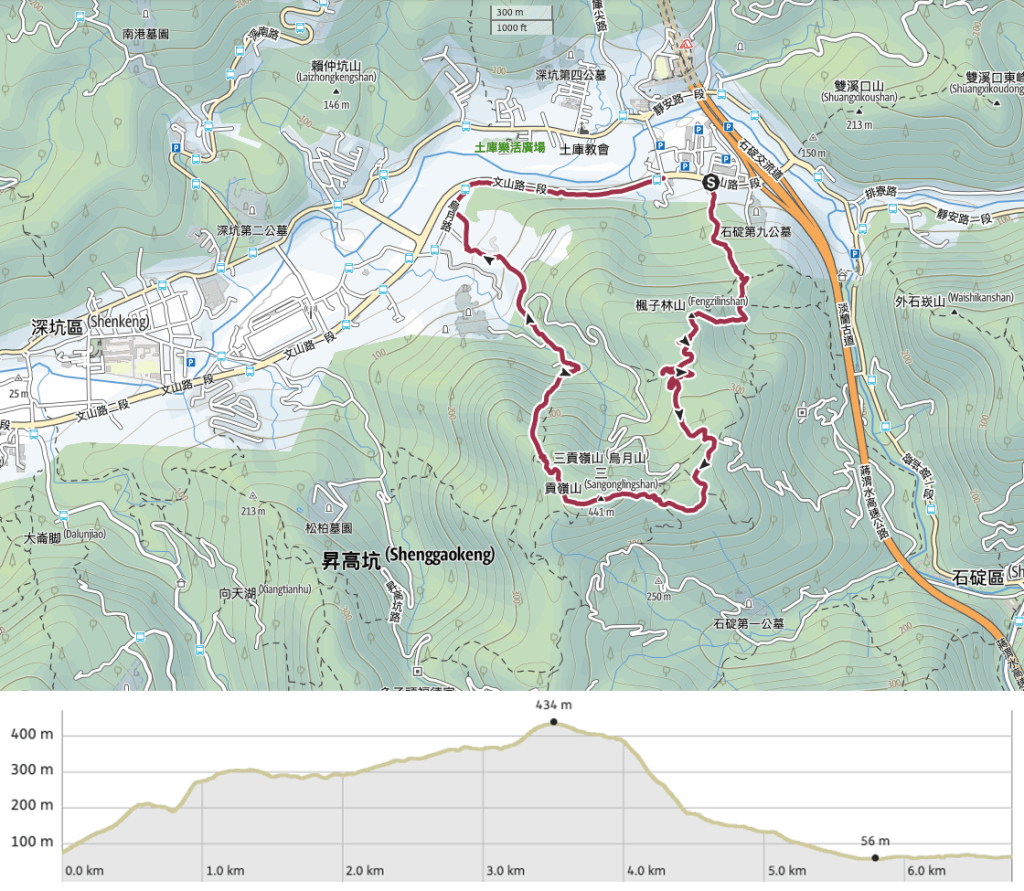
Distance: A little under 7km.
Time: It took us 3½ hours at a reasonably quick pace (for us).
Difficulty (regular Taiwan hiker): 2/10 – A little steep and slippery, we ended up taking an easier route down because it was hard to see where the hikers whose blog were had used as reference went.
Difficulty (new Taiwan hiker): 4-5/10 – This one might feel a little too sketchy if you’re not familiar with the less frequently traversed trails you can find at lower elevations. Signage is only in Chinese and not all trails and tracks appear on any maps.
Total ascent: About 350m.
Water: 0.5L was enough for us on a cool winter’s afternoon, but in summer I’d take a litre just to be safe. We also took some nuts and dried tofu to snack on.
Shade: Most of the trail was quite shady, but on sunny days there would be enough exposed areas that I would need to take precautions. A sun hat and long sleeves would be a more sensible option than an umbrella on this trail.
Mobile network: A bit patchy, both of our networks (Chunghua and Taiwan Mobile) areas where they had limited or no service.
Enjoyment: It took me a while to get into this one, but the more I think about it, the more I like it. It has history and a little wildness and is beautiful in its own forgotten way.
Other: I’d recommend wearing long trousers at a minimum, and probably long sleeves too. We picked up one leech doing this walk (it didn’t manage to get a meal, but it hitched a ride back to our apartment). You’d also be better off with a hiking stick and/or gloves to help on some of the steeper sections.
Permit: None needed.
Route type: Loop
Jump to the bottom of this post for a trail map and GPX file.

We parked in Shiding Service Station and made use of both their toilets and the convenience store before setting off. The trail starts just across the road from the carpark and begins by taking you up a lane past a few houses.

In the garden in front of the last house, we met this kitten resting on top of a farmer’s hat that had definitely seen better days.

Beyond the house, the trail passes through a small area of farmland then enters scruffy secondary forest.

Almost straight away we spotted the first animal of the walk: a Formosan wolf snake (sadly, deceased). These distinctively marked beauties aren’t venomous, and I think this was the first time that I’d ever seen one – hopefully, next time it’ll be a little more lively.

At several points, we noticed that the trail splits in two for a short way only to merge again, and after puzzling over it for a bit, we came to the conclusion that the winding, less steep trail had been made for scooters. (This also explains why concrete had been laid down in some places.)


The steps in the previous photo lead to this shack (if you take the more leisurely route you’ll miss it). A sign above the door says that it was built for people to come and meditate in, which explains the raised bamboo platforms and foam squares. The construction techniques on display remind me of the “gadgets” that we used to make in Girl Guides.

Further up, we passed a collection of abandoned scooters, one still with keys in the ignition and another growing a fern out of a hole in the seat.

This is another of those false junctions. The one on the right goes a little way further before looping back to rejoin the steps. In some places, the steps retain a very historic trail type of feeling

At one point the trees to the left of the trail disappear and there’s something of view to be had…although it’s not the most beautiful view I’ve seen in Taiwan. You can see Freeway No.5 as it emerges from a tunnel beside Shenkeng Service Station. It’s not visible from here, but under this part of the freeway there is quite a pretty and easy section of the Tamsui Kavalan Trails.

At this junction, you need to take a right. There is a sign pointing you towards Fengzilin Shan, but when we went it was upside-down and pointing the wrong way.
We walked another five metres or so until passing a trail that merged on the left. I knew that wasn’t the right direction, but I glanced back that way anyway, and was startled to see a male Swinhoe’s pheasant chilling in the middle of the trail. We stopped to watch it for a while, and to our surprise it didn’t seem in the least bit bothered by our presence. He paced backwards and forwards on the path for a while before emitting a series of high-pitched click-squeaks and then shimmying hiss feathers. Not only was he not bothered by our presence, but he was feeling comfortable enough to get on with his mating performance. We stayed with him for maybe 10-15 minutes, watching him strut his stuff before he then disappeared into the bushes.

We continued our journey and soon the reason for the scooter-accessible trail became clear. At the end of the trail there’s a little patch of farmland next to a collection of old stone houses.

The farmland is still tended to, but most of the buildings look rather sorry for themselves. One part has been fitted with a metal roof to prevent it from disintegrating any further.

A man was looking after the plants and a woman was washing leaves in a sink. She said there are usually more people passing through on a Sunday, but the day we went she’d hardly seen anyone.

One of the buildings still has a visible house number : No.4 Lengfankeng, Shiding.

By peering into the trees it is possible to make out quite a lot of old stone walls, it seems that this was once a small mountainside village. The first houses built here belonged to settlers from Quanzhou, and when it was at its most populous there were around a dozen or so households living here, and the trail would have been far busier than it is today given the fact that it was one of the main trading routes connecting Taipei to Pinglin. According to Tony Huang’s description of the place, the name Lengfankeng (“冷飯坑” translates character by character as “cold rice pit”) stems from the fact that tea farmers and traders used to stop here to rest and eat on their way down from the hills, and by the time they made it to this spot, their rice was invariably already cold.

Not all of the walls are still standing strong, but the wide facade of this one looks mighty solid. It must have been really dark with a roof on though, those barred windows wouldn’t have let in much light.

A little way beyond the houses we took a right turn under all of these hiking tags and started to climb.

The trail goes up quite steeply, and it’s a contrast to the gently meandering path of earlier on. (Photo from our second walk here, hence the sudden change of clothes.)


After about 15 minutes of climbing we arrived at Fengzilin Shan (楓子林山) and stopped for a quick snack. I think there should be a view, but all we could see was a wall of white.

By the time we were ready to get going, the clouds had well and truly descended upon us, beading our hair with tiny droplets of rain, and making 3pm feel more like 5pm.

The trail battles through several metres of overgrown silvergrass (one of the seed heads gave me a damp slap in the face) before emerging onto a wide track.

It was a strange landscape to find ourselves in and really rather different from what I’d been expecting. At the first wide open area keep to the left and follow the track. There are a couple of side tracks, but keep on this main one for now.

It looks like this area has had a past life as a golf course because we found many muddy white balls lodged in the banks beside the road.

There are several joining tracks at this point, head down to the first junction and take a sharp left, soon after you’ll need to take a sharp right and then you will find yourself climbing up the track that’s visible in the distance here.

This is where you’ll need to take that right turn, the track on the right is hidden until you’ve moved past these huge concrete tubes.

From here on out you might notice that the image quality (and weather) is a little different, that’s because the rest of the photos came from our second attempt to finish the walk. This was taken looking back down the slope in the direction of Jiangziliao Shan.

At one point the track rounded a corner and we found ourselves looking directly at our next destination: Niaoyue Shan. Just below and to the left of the summit there is a 3-4m high Guanyin statue.

Keep following the muddy tracks as they wind uphill, stick to the right here – there is another track on the left but I can’t see where it goes.

At this junction you need to take the less defined track on the left.

And here head straight over, just ignore the fainter track on the right.

We went briefly wrong here by going up to the right. Instead you need to keep to the flat and head straight (in the direction of the cherry trees).
There was a surprising number of cherry trees planted along the side of the road. I wonder why the land hasn’t already been turned into leisure farms/campsites.

After passing an area of fenced-in land on your right, keep your eyes open for this barely there trail. It cuts through unruly silvergrass for maybe 20 or 30 metres and then opens out on the edge of the retreat/temple compound where the golden Guanyin statue is located.

The trail sticks right to the edge of the property and immediately takes a left into the trees once more. I spotted someone watching us from across the clearing and raised a hand in greeting, but they just stared back. I get the sense hikers are either uncommon or unwelcome, or both.

From the temple’s land it’s all climbing until you reach Niaozui Shan. There are stone steps for much of the way, the kind that suggest that the path was once a historical trail – it’s not entirely a surprise, this whole area was settled extensively by farmers in the past.

The trail here is clear, but obviously not so frequently traversed. Ferns crowd in from all sides, and I remarked to Teresa that it would be unlikely that we’d return from the walk without one of us picking up a leech.


The second peak of the walk is Niaoyue Shan and it sits in its own little clearing just beside the trail. There’s a triangulation stone, but nothing else to make it noteworthy, and so we stopped just briefly before continuing on.

A short way from the peak there is a junction. Take the right trail here towards Bandit’s Cave (土匪洞).


There is a slightly steep descent and the forest had that dark, hushed, heavy atmosphere that you sometimes get. If I’d been alone I would have felt vaguely spooked, but Teresa is a tough’un and when she’s with me I rarely feel scared. Besides, who has time to feel negative feelings when there is so much ferny beauty on display.

Immediately after a steep scramble down some tree roots there is another junction. Take the trail on the right which cuts down through a steep-sided gorge.
At first we took the wrong way here, just by looking on the map, it appeared that both routes would take us to the same place, so we chose the flatter one heading to the left of a rocky outcrop. Once on the far side, it climbed sharply to the top of the pinnacle and terminated at the top of a sheer drop all the way down to the trail maybe 20 metres below (I am terrible at gauging distances though, so it may have half or double that). That’s why the paths seemed to meet up again, but only someone with abseiling equipment would be able to make it work.

Somewhere high up on the right I could hear water, a small flow cascading over the higher rocks, the sound amplified by the tightness of the ravine.

Soon we found ourselves at the bottom of the impressively large rock face. It’s far more imposing than the nearby Bandit’s Cave, but it’s clear that the twin features would have been useful to anyone wishing to defend the area. However, the name handwritten on all the signs – “Bandit’s Cave” or “土匪洞“ – is something of a misnomer, or at the very least a rather one-sided interpretation. This is the name given to it by Japanese occupying forces, but to the Han settlers who fought to defend the land it was known as General White Horse Cave (白馬將軍洞). (I suspect that the former name was used because it’s shorter and therefore easier to write.)
When the Japanese army invaded Taiwan in 1895, there were several groups of resistance fighters who sought to undermine their new and unwanted leaders. One group was led by Chen Qui-ju (陳秋菊), a local who garnered the nickname “General White Horse” – hence the cave’s alternative name. Chen corralled a group of fighters which, at their peak, grew to about 2000. The rebels occupied the hills and forests to the south of Taiwan, around Jingmei, Shenkeng, Pinglin and Xindian, and for three years they caused trouble for the Japanese army, aided by their superior knowledge of the terrain. In 1898, Chen saw the writing on the wall and, knowing that there was little point in continuing to fight, he decided to surrender. It seems like this was ultimately a smart move, as Chen went on to live a relatively prosperous life – his previous efforts shielding him from receiving too much criticism from his countryfolk. If you’re interested, you can still visit his house in Shenkeng. It’s a lovely red brick building in the Southern Fujian style, and can be found on Lane 39, Wangdan Road. (See below for GPS coordinates.)

Beyond the cliff and cave, the trail continues its way downwards, and before long we came across an out-of-place feeling flight of concrete stairs. Part way down there’s a natural overhang where stone chairs and tables have been added – I doubt many picnic-ers come up here though.

When you spot this water tank you’ll know you’re almost back at the road. Just beyond here there is a junction, keep left and head downhill.

This section of road looks like it is very rarely used, and as such it’s unpleasantly slippery. We had to take great care when walking so as to avoid slipping.

There is a carpark at the trailhead (it was entirely devoid of cars), and from there the road heads down to run past a temple (on the left), and a mountainside KTV (on the right). Keep heading down along the central road.

A land god temple built into the side of the hill.


This one looks like it’s been here so long that it’s grown together with the tree. To the right of the little temple there was a second altar, perhaps dedicated to the tree, perhaps something else. Whatever had once been written on its plaque had long since been erased by the passing of time.

The road we were on joined with another road coming down from the right. Keep left here.

When the road reaches a collection of houses take a right turn. From here on out the rest of the journey is on the flat.
*If you arrived on public transport then you might prefer to take a left and make your way into Shenkeng for dinner before catching a bus back.

We passed through a row of old building being used to house pigs—their horrifying shrieks coming to us in the gathering dusk set the hairs on the back of my neck standing, even though I knew exactly what was making the noise. At the end of the road merge right onto the 106 and keep following it until you’re back at the service station.

By the time we got back, it was fully dark, and I think we’d just managed to complete the walk and all associated faffing around at the start and end within the service station’s four hour stay limit.
Getting there
Google Maps address: The trail starts from in front of Shiding Service Station and rejoins the road just behind Shengkeng Dao Zu Temple. If you plan to do the loop walk then you can park at the service station, but be aware that there is a four hour stop limit. If you’re only interested in climbing to the cliff and cave then you can drive up to the temple mentioned above.
GPS location:
- Shiding Service Station trailhead – N25 00.480 E121 38.690
- General White Horse Cave trailhead – N24 59.995 E121 38.280
Public transport: This one would be pretty easy to do on public transport. Make your way to Xindian MRT Station, then transfer to the 923 bus (buses go from the main Xindian Bus Station). Ride the 923 as far as Fengzilin Road Intersection, then once you alight you’ll have to keep walking in the same direction as the bus was headed for about 150m until you reach the service station.
Further reading: If you can read Chinese, then Tony Huang’s post on the cave and cliff is worth a read. That’s where I got most of my information from.
Nearby trails:
- Bijia Ridge
- Huangdidian
- Nangang Tea Mountain Trail
- Tamsui-Kavalan Trails: Fuyang Ecopark to Shenkeng
- Tamsui-Kavalan Trails: Shenkeng to Wutuku
- Yue Shan Hu Cliff Trail
My new words learnt on this hike:
- 静思 / jìng sī – mediate
Fengzilin Shan Trail Map
GPX file available here on Outdoor Active. (Account needed, but the free one works just fine.)
