
Sometimes you feel like a grand adventure somewhere far from home, but what about the days when you can’t stray too far, or when you want the thrill of exploration without the hassle of all that travelling? This walk is perfect for one of those days, a great little backyard adventure.
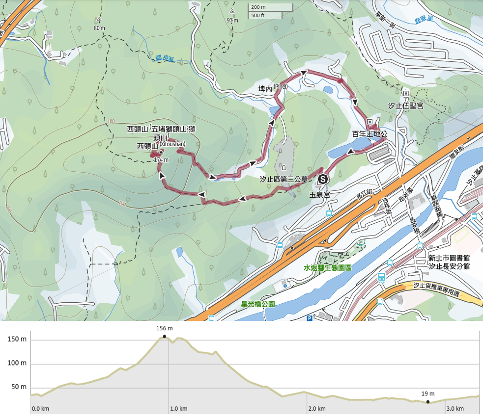
Distance: 3.3km – if you do this as an out-and-back trip to the peak it would be shorter, maybe just about 1.5km.
Time: Around 2-2½ hours.
Difficulty (regular Taiwan hiker): 2/10 – Steep in sections and slippery in the rain.
Difficulty (new Taiwan hiker): 4/10 – Steep trails, uneven surfaces, slippery in wet conditions, noisy dogs on the road.
Total ascent: About 140m to its highest elevation of 174m.
Water: 0.5L should be enough except for on very hot days. The temple at the start of the trail has a hot/cold water dispenser so you can fill up your bottle there.
Shade: On a sunny day I would have used an umbrella for the road section,
Mobile network: One or two areas without service, but generally ok.
Enjoyment: I enjoyed this walk a lot considering that it’s really nowhere and nothing special, the rural scenery of the return journey along the road was particularly pleasant for me, it reminded me of home.
Other: There are a few noisy dogs on the way back. The noisiest ones (the only genuinely aggressive ones) were tied up, but the others weren’t.
Permit: None needed.

The trailhead sits behind Yuquan Temple (玉泉宮), and we parked our scooter under the temple’s main level. I’m not sure we were meant to, but there was also nothing and nobody to tell us not to.
It’s worth taking a little look around the temple before setting off on the walk. The three altars inside its main hall are flanked by two of those giant god guard costumes which get taken out and paraded around the streets during special occasions.
In a side building dedicated to Tiandou Yuanshuai (a deity with a crab painted on his face), we found an altar for a horse, probably the steed of the gods above it. The horse deity had hay and a bowl of water filled with coins that had been there so long that they’d formed layers of white-green crystals. Another side chamber held an intricate model of an old temple complex. And above one of the doors was a massive (and thankfully abandoned wasp nest), maybe left there on account of the fact that it indicates the building’s positive feng shui – or perhaps left there to dissuade the wasps from returning.

The trail starts by heading behind the temple heading away from the right side of the building as you face it.

Steps climb up through a tunnel of trees, and an information board stated emphatically using a whole load of words that this is not just Wudu Lion’s Head Mountain Trail, it is Wudu Lion’s Head Mountain Non-Smoking Trail. We didn’t need to worry about renegade smokers, we were the only ones on the trail that day.

Like so many other lower-elevation trails a little outside of the cities, this one looks to have been cared for at some point but left to its own devices in more recent years. There are picnic tables that are plastered with algae and being gradually consumed by nearby trees.

There are quite a few graves on these slopes (well, probably on all of the slopes near Taipei if you stop to think about it).

The trail climbs to a summit of sorts, where we found a tall pylon buzzing and crackling in the wet air. Then from there, it dips down for a while.

There are one or two side trails, but they’re all unpaved and unsignposted so it’s always clear which way you need to go.

At this junction where the steps continue up to the right, we found a faded and cracked old map. Despite its uselessness as an actual map, I found it quite pretty, and I was childishly tickled by the English name of Fuming Temple (福明殿).

After turning right, the trail starts its steepest climb, and from here it’s up all the way until you reach the top.

Slippery wooden steps were replaced by equally slippery stone steps.

And it got even steeper.

Shortly before arriving at the summit, the path cuts through this interesting feature, a narrow slot between shoulder-high rock on the one side and a towering wall on the other. The way runs for maybe 20-30 metres, and is more impressive if you reach the far end and turn back.

The path climbs to a four-way junction. We would later take the trail leading straight over (signposted as going towards Lane 167, Section 2, Xiangzhang Road), but before that, we took a left and walked the remaining ten metres to the peak.

At a mere 174m high, Lion’s Head Mountain is the lowest of all of those that I’ve visited so far, but despite that, it offers pretty good views of the surrounding land – good enough for the location to have had a previous life as a military observation point.

It was drizzling when we visited, so the nearby hills were all rather cloud-covered, but looking south we could see a local service train pulling into Xizhi train station. (That odd white structure in the foreground is Starlight Bridge.)

Returning to the main trail, we went right and started to head down.

Just before the serious business of descending got underway there was one final view looking out over the hills to the north of us.

A few trees were attempting to put on a little bit of an autumn display, and although it’s not as impressive as the reds, oranges and yellows I grew up with, I still enjoyed the warm colours.

As I was admiring red leaves, Teresa was busy appreciating the bright green fresh new fern growth.

The further down the trail goes, the more bamboo we saw. At first it was just this type of skinny-stemmed variety, but later it became more of the taller, woody stuff.

A beautiful moth (belonging to the Histia genus). There are a lot of these about at the moment.

More and more signs of past habitation appeared. This is a runoff channel from an old reservoir, presumably for watering bamboo and farmland.

Then when the giant bamboo starts you’ll know you’re very close to the houses.

The first building we came across was this old shed. It looked like it was being used to house farming equipment.

Beside the shed was an old fish pond that had been entirely taken over by water lilies.

Fish ponds seem to be a common feature in the area because we soon found ourselves passing a second (still cared for) one.

Just beyond that second pond, we found ourselves back on the road (well), more like a track at this point). Sat at the dead end of the road was this lovely little brick building. That second-floor balcony is just so lovely. It looks like the brick part is no longer inhabited, but the adjoining building clearly still has residents (and a resident cat which enjoyed licking Teresa’s finger).
The brick house had another pond, and as we passed it I saw a brilliant flash of electric blue kingfisher flitted away. A little further along we were greeted by a pair of barking dogs who rushed out to greet us. Their mum, an older woman, assured us that they just enjoyed making a noise, and said that we didn’t need to worry about the dogs further along the road either since they were all chained up.

Continuing our journey down the road we passed a bizarre fish tank built into a wall. I’m pretty sure these tilapia are destined to make their way onto someone’s dinner plate.

A cacophony of barking greeted us as we passed by this row of buildings. Three pitiful-looking dogs were chained to shelters beside the road. I’m not convinced that they were barking out of aggression, more likely fear or habit, or just because they couldn’t escape. One cowered behind a tree, another barked menacingly then lunged to grab a mouthful of rice as we passed, and the third remained passive and just watched us with large, doleful eyes. From the far side of the road, a cat observed the whole scene without even a flicker of an expression.

After crossing a stream, the road hits a junction, keep right and follow the road through more farmland.

You see some odd things down rural roads here. Like this huge stack of Yakult bottles (or other similar product). What led to them being there? Why have they been left there for so long?

Another interesting sight was this flock of chickens roosting a full three metres above their coop. I had seen the coop and knew there should be chickens in it because I could hear them, but I didn’t see them until I stepped back and looked up.

An abandoned house sits by the side of the road, its windows painted in distinctive Taiwanese turquoise.

Next to the abandoned house, there is a well-maintained shrine. The writing on the stone stele within the structure calls it Red Woman Ancestral Shrine (鄉長里紅姑娘祠). Despite the intriguing name, I can’t find anything about the temple online. Who was the red lady? Or is it perhaps just a surname?

Eventually the road curved around one edge of a pond which looked familiar, and I realised we had walked back as far as the turn-off for Yuquan Temple. Take a right turn uphill right in front of a land god temple, keeping the lotus pond on your right.

Take a right turn uphill right in front of a land god temple, keeping the lotus pond on your right.

After the lotus pond, there is a second, bigger pond which looks like it’s used as a fishing lake. This guy had the prime spot in his own little hut.

The grey sky was beginning to darken by the time we made it back to the scooter. Something about Xizhi makes always appears in my memory like this, rather grey, but moments after this was taken we were treated to some spectacular sunset light.
How to get to Xixhi’s Lion Head Mountain
Google maps address: The walk starts from behind Yuquan Temple, there’s some parking space for both cars and scooters below the temple, and a lot of cars park on the side of the road leading up to the temple.
GPS location:
- Temple trailhead – N25 04.900 E121 39.910
- Xiangzhang Road trailhead – N25 04.920 E121 39.680
Public transport: It’s a fifteen-minute walk from Wudu Train Station to the trailhead temple (turn right onto Xiangzhang Road, turn left and cross Keelung River on Chang’an Bridge, head straight and pass under the freeway, pass a 7-Eleven, then when the road comes to a fork take the left turn, then left again at a small land god temple).
Nearby trails:
XIZHI LION’S HEAD MOUNTAIN TRAIL MAP
GPX file available here on Outdoor Active. (Account needed, but a free one works just fine.)
This is the bit where I come to you cap in hand. If you’ve got all the way down this page, then I can only assume that you’re actually interested in the stuff I write about. If this is the case and you feel inclined to chip in a few dollars for transport and time then I would appreciate it immensely. You can find me on either Ko-fi or Buy Me a Coffee.
