
Forest bathing and a very easy Xiao Bai Yue in Taoyuan’s Fuxing District
Long-time readers of this site may or may not have noticed that I have been adding–slow step by slow step–to a growing compendium of trail guides on Taiwan’s Xiao Bai Yue. While they may have “小” (or “little”) in their name, that’s only because they’re named in contrast to their 3000m-plus cousins. In fact, there’s often nothing diminutive about these peaks at all. Mount Dongyan is a case in point. At 1212 metres above sea level, it is higher than the highest mountain in three of the four countries that make up the UK (only Scotland’s Ben Nevis stands higher). But despite this, the walk is easy enough even for most casual walkers to enjoy. This has been one of my favourite Xiao Bai Yue to date, purely for the wonderful forest park that you see along the way.
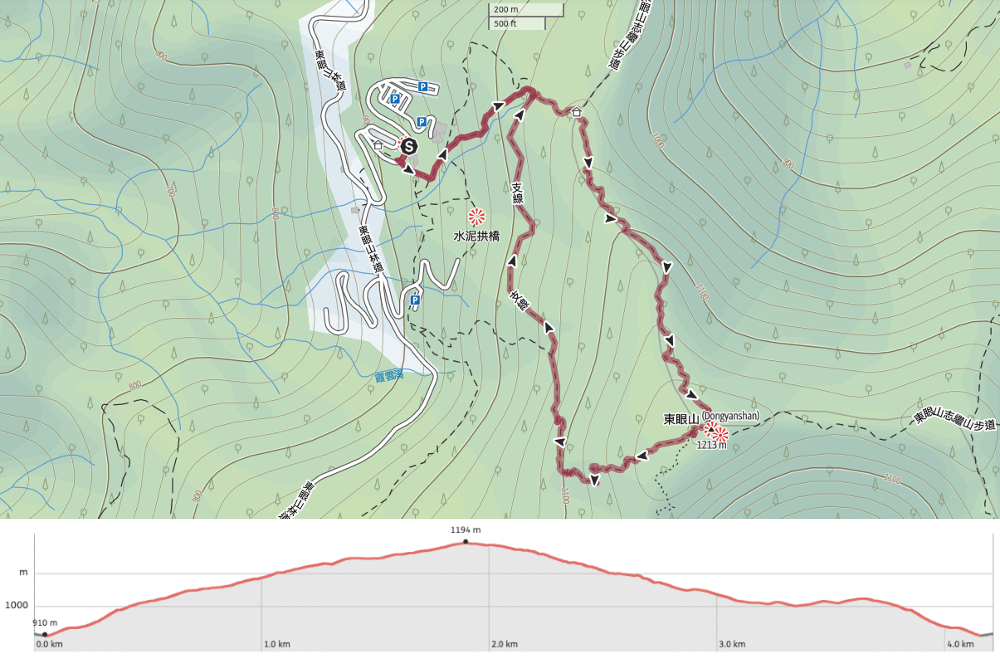
DISTANCE: A little under 4km.
TIME: 2½ to 3½ hours. I spent a little over three hours on this trail, but stopped quite a lot to enjoy the quiet.
TOTAL ASCENT: Almost 300 metres.
DIFFICULTY (REGULAR TAIWAN HIKERS): 3/10 – Some elevation gain, but getting to the park will be the biggest hurdle for most people.
DIFFICULTY (NEW HIKERS): 4-5/10 – For elevation gain, uneven (sometimes slippery surfaces), and the challenge of making your way to the park.
SIGNAGE: Lots of bilingual signage, but it’s not always helpful. A lot of the way, you’re following signs for “Seldfguided Route (Triangulation Stone). Once you know that, it’s easy, but it isn’t perhaps the most logical name for the route.
FOOD AND WATER: I was fine with just 0.5L on a cool autumn day. There’s a hot and cold water dispenser at the starting/ending point of the trail, so it’s easy to top up is if you run out.
SHADE: This walk is shaded more orless from start to finish.
MOBILE NETWORK: Pretty clear the whole way.
ENJOYMENT: As well being able to tick one of the Xiao Bai Yue off of your list, this is a lovely walk in its own right. Even if you don’t get to enjoy the view at the top, the forest scenery is top-class.
SOLO HIKE-ABILITY: Not only is this a very safe choice for solo adventures, but I would also actually encourage you to seek this out on your own. I went on a Monday morning, and saw no one for the first three hours of my walk. It was ridiculously peaceful.
OTHER: It’s worth noting that due to its elevation, the weather in the park is generally quite a bit cooler than the weather in the cities. Check the local forecast before you go and plan accordingly. Some hikers do a considerably longer and tougher route which includes Mount Zhiji and Mount Laka.
TAIWAN 100 MINOR PEAKS: Number 22
ROUTE TYPE: Loop
PERMIT: None needed but you do need to pay to enter the park.
Jump to the bottom of this post for a trail map, GPX file and ticket information.
DIRECTIONS:


I was one of the very first park visitors through the gates on a Monday morning, and the first to pass the visitor centre on my way to climb Mount Dongyan. It’s worth nipping to the loo in the centre before you set off, because there are no bathroom facilities anywhere on the trail after this. To get going, take the trail leading to the right of the visitor centre and start climbing.

At the first junction you hit, take a left turn and head up following the signs for the “Self-guiding Trail” and “Triangulation Point”. In fact, from here until the top, you’ll be following signs with this text.

An ugly water tank is obscured from view by this rather lovely bug hotel. I particularly appreciated how the logs had been drilled and stacked to make each of them look like alarmed or puzzled faces. It would have been interesting to have a little sign indicating what species they are expecting to visit the hotel, but it looks kind of new, so maybe it just hasn’t been added yet.

At the next junction, continue on upwards. There are many interlinking little trails in this lower section between the visitor centre and the restaurant, and I feel that families with young children could probably spend a happy morning fairy-hunting or leaf-spotting without going much further than this.

Apologies for how dark this is, but I wanted to show the sparkle. At first I thought it might be morning dew, but after closer inspection, it was clear that the sparkle was coming from some of the crystal grains.


The lower parts of the trail were mostly stone-tiled steps, then later wood. Beside the trail, there are also benches and shelters for hikers to rest and enjoy the quiet. This elegant shelter on the left is one of several such structures that have been created by students of Tamkang University’s Architecture Department during annual fortnight-long forest-based workshops. They’re built using cedarwood that has been felled as part of the Forestry Bureau’s thinning program, following the core philosophy of “Take from the forest, use in the forest”.

At the next junction, keep heading straight on and up. (Later, the trail loops back on this righthand path.)

There were quite a few of these Hemiboea bicornuta (角桐草) plants growing next to the trail.


I felt so lucky to have the park seemingly to myself. The forest was alive with the chatter of birds and breath of the wind. At one point, I stopped to observe a group of Taiwan scimitar babblers putting on a perfect demonstration of where their name comes from.

Further up, the wind got stronger, causing the trees to sway and creak. The trail also became somewhat flatter as it followed the spine of the ridge.


When you start noticing these old utility poles, you’ll know you’re almost at the top. Then, when you spot these steps, you’re just metres away.


Mount Donyan sits a pleasing 1212 metres above sea level, and has benches arranged around a small clearing at the summit. This isn’t the highest point though. That is a little further away up a flight of steps.

A wooden viewing platform with some of those huge fixed binoculars affords visitors views over the landscape to the north. I tried the binoculars, but there were so cold that I got brain freeze from pressing my brows to the metal! It’s hard to make out in the photo, but it’s possible to see some of Taipei’s rivers, as well as several city districts in both Taipei and New Taipei. I also glimpsed the ghost of Mount Guanyin through the clouds. A sign here says that in clear weather you can see Mount Qixing and the other mountains in the Mount Datun Volcanic Group, but I only saw clouds.
When I was ready to head down, I retraced my steps to the clearing, then took the other trail leading down from the opposite side to where I’d climbed up.


On the way down, plenty of things caught my attention. The first were these spindly black-stemmed mushrooms. Something about them is somehow simultaneously beautiful and repugnant. The next things to pique my interest were these signs (there were a few of them). The Chinese asks visitors to limit the number of people on a section of walkway, but the picture… I’m not sure. Are they treading water? Dancing? It’s an odd one.

I am glad I chose to walk the clockwise loop. The trail heading down was especially beautiful and I enjoyed taking my time.


Much of forest was made of up Japanese cedars–the tree which was the go-to species for most of the historical reforestation projects that have been undertaken in Taiwan.

They grow tall and straight, often preventing much light from reaching the understory, and making it hard for other species to become established. But the higher up you go, the less dominant the cedars are.

This path was just so pretty. The steps on the way down were all wooden and blended into the environment nicely, and where there wasn’t any need for steps, there was a narrow dirt path.


Several spots along the way had these markers indicating that they were soil monitoring locations. I am curious to know what exactly is being monitored, but I didn’t see any information about it.

Another interesting feature was the many trees that had been tagged with red ribbons–although in this case, the purpose was very clear. They were all either dead or precariously leaning trees that had either been earmarked for removal or else put on the watch list.


The path heads down to a junction. If you want to complete a loop and head back to the Visitor Centre, you’ll need to take a right turn here. (Taking the trail on the left will get you to the restaurant.)


A tree lizard giving me the stink-eye close to the end of the trail.

When I got back to the visitor centre, I refilled my water bottle and made a coffee using the hot water dispensers, then set off to explore the next part of the park.
Getting to Dongyanshan National Forest Recreation Area
Google Maps address: If you’re driving, you can navigate to Dongyanshan National Forest Recreation Area. There are a few parking spaces outside the park entrance, but if you choose to drive into the park, you’ll want to head to the carpark beside the visitor centre for this trail.
GPS location: N24 49.875 E121 24.590
Public transport: It is possible to visit Dongyanshan using public transport with just a little foreplanning (and a couple of transfers and a lot of time).
The 506 Taiwan Tourist Shuttle service departs Taoyuan Daxi Bus Terminal three times a day on weekdays (8:00, 11:00 and 15:00), and five times a day on weekends (8:00, 9:00, 11:00, 14:30, and 15:00). Similarly, there are three return services on weekdays and five on weekends with the last bus departing the part at 17:00. I wouldn’t advise catching any of the services after 11:00, because they won’t give you enough time to explore.
If you’re coming from Taipei, it is possible to arrive at Daxi in time to get the earliest bus by using a combination of buses or a train and a bus journey depending on where you’re starting from. The easiest way would probably be to catch a local train from any of the Taipei stations to Yingge. Then alight at Yingge and catch the 5101 bus from the stop in front of the station and ride it to its final stop at Taoyuan Daxi Bus Terminal.
Nearby trails:
- Dongmao Trail
- Dongyanshan Forest Trail
- Qinzi Peak Trail
MOUNT DONGYAN TRAIL MAP
GPX file available here on Outdoor Active. (Account needed, but the free one works just fine.)
Come and say hi on social media:
If you enjoy what I write and would like to help me pay for the cost of running this site or train tickets to the next trailhead, then feel free to throw a few dollars my way. You can find me on PayPal, Buy Me a Coffee or Ko-fi, (and if you’re curious about the difference between the three you can check my about page).

Beautiful trail
LikeLiked by 1 person
The whole of Dongyanshan National Forest Recreation Area is really pretty. The light filtering through the trees is just gorgeous.
LikeLike