
RAKNUS SELU TRAIL – SECTIONS RSA42.2 – 46.2
Finally, after taking a hiatus over the hotter summer months, I got back to the Raknus Selu Trail for another few days of walking. Over three days, I travelled from Xindian Old Street to Zhuolan via Chukuangkeng and Dahu. This post covers the first of those three days as I walk from Xindian Old Street to Chukuangkeng.
RAKNUS SELU STAMPS: There are three stamps that can be picked up by someone walking this section, but I’d already collected one on a previous visit to the area.
- RSA41: Located in the Little Blue House close to Shitan Yimin Temple. This is kept at the rear of the house and hikers can let themselves in through the gate to stamp it.
- RSA43: Located in Xindian FamilyMart.
- RSA47: Located inside the Chuhuangkeng Oil Field Cultural Museum. This is open 9am-4pm daily except for on Mondays.
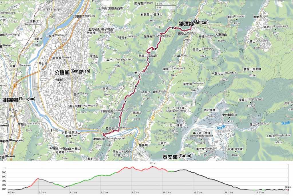
DISTANCE: About 18 km.
TIME: I spent about six hours walking from point to point, and more time walking around the old oil fields and sourcing dinner.
TOTAL ASCENT: About 1,000 metres.
DIFFICULTY (REGULAR TAIWAN HIKERS): 3-4/10 – Almost purely for distance and cumulative elevation gain. This is an easy walk. But it’s long and the road is hard on your feet.
DIFFICULTY (NEW HIKERS): 4-5/10 – The nature of this walk means that it’s probably almost equally challenging for regular Taiwan hikers and fit hikers new to Taiwan. Only the distance is challenging.
FOOD, DRINKS & PIT STOPS: You’ll need to take at least enough food to last the day and enough water to get you as far as Xieyun Temple. I only took 0.5L. It was just OK on a cool day, but had it been even a little hotter, I would have needed double that. There are a lot of food options at Xindian Old Street. If you’re there when it’s open, I highly recommend the herbal tea (仙草次) from this store, and snack-wise, you can stock up at the convenience store. There is water available at Xieyun Temple, but that’s it. When you arrive at Chuhuangkeng, you can find some very basic provisions at the oil field museum, otherwise, you’ll need to catch a bus towards Wenshui Old Street. There are lots of food stalls here, as well as a convenience store. I caught a bus here to get dinner, then caught a bus back again later when it was time to go to my B&B.
TRAIL SURFACES: This walk had a real mix of road, farm track, historic trail, and dirt track.
SHADE: I walked this on a very overcast day, so I was fine with just sun cream, but on a sunny day, long stretches would be very exposed.
MOBILE NETWORK: Mostly ok, with a few weaker spots.
SOLO HIKE-ABILITY: The two biggest risks on this walk would be feral dogs and monkeys, so depending on your familiarity with both species, you may or may not be comfortable alone. Also, for solo women, the remote roads might feel a little stressful. That said, of the many drivers who stopped and chatted to me, every single one was just concerned that I was lost and/or in need of assistance.
SECTIONS COVERED:
- RSA42.2: Miaoli District Road 26 → Xie’ai Historic Trail Trailhead (苗26→楔隘古道口)
- RSA43: Xie’ai Historic Trail (楔隘古道)
- RSA44: Xie’ai Historic Trail → 100-Year-Old Qiedong Bogong Temple → 100K → Chongku Shan Trailhead (楔隘古道→百年茄苳伯公→110K→沖庫山登山口)
- RSA45: Chongku Shan Trailhead → Xinshimen Shan → Xieyun Temple (沖庫山登山口→新石門山→協雲宮)
- RSA46.1: Xieyun Temple → Miaoli District Road 2 (協雲宮→苗2)
- RSA46.2: Taiwan Provincial Highway 6 (臺6)
Jump to the bottom of this post for a trail map, GPX file and all the other practicalities.
DETAILS & DIRECTIONS:

I started my day by waking up in the mist-shrouded environs of Longtung Temple after having slept a ridiculous 10 hours. (There was not much to do up here at night except for sleep.) I had a little wander around before the shuttle bus came and I was the only passenger on the journey back down Xindian Old Street. The driver, who admitted that he could “keep talking as far as Kaohsiung” was indeed a chatty fellow who told me that he’d grown up in the area as the third generation of an immigrant family because his grandpa married a Hakka belle and settled in the area. He dropped me off in front of the library on Xindian Old Street.


08:40 – From the library, the RST heads southwest along the street to the junction with Hsinchu District Road 124. Cross straight over and walk across a bridge decorated with happy strawberries and oranges. I got some buns here for my breakfast. One was stuffed with sweet peanut paste and the other, studded with raisins.

08:49 – The FamilyMart on the corner is where you’ll find the stamps for RSA43, Xie’ai Historic Trail (楔隘古道 or perhaps 錫隘古道, I’ve seen both).


I popped in to stamp my trail passport and pick up provisions for the day ahead. A middle-aged woman who seemed to have some kind of learning difficulties followed me around asking what I was going to eat and if I could buy her breakfast. By the looks of it, she is probably here often doing this, but I figured that spending a few extra dollars to get her breakfast wouldn’t hurt, so I got food for the both of us then set off again.

09:03 – The Shitan Township lion mascot stands at a junction at the far end of Xindian next to a pile of oranges and a sign for Xie’ai Historic Trail. However, it’s still a short uphill walk from here to the trailhead. Pass the lion and then turn right up Miaoli District Road 26.

09:13 – Keep following the road uphill for several minutes, and you’ll soon find yourself at the trailhead for the day’s first section of trail.

09:16 – The first minute or so follows a farm track up to this spot where you’ll find a trail map and a sign directing you to turn right and cross over a bridge.


As soon as you step foot onto the trail, it is evident that you’re walking on old steps. The stones have been worn to fit the footfall of travellers and gone-wild bamboo creaks and groans around you.

The trail becomes steep steps carved directly into the rock and approaches an almost sheer cliff. Thankfully, the pretty ferns (and the absence of mosquitos in the cool and windy December weather), meant I was happy to stop to catch my breath. It was also around this point that a large troupe of monkeys started barking at me from up in the trees.

I was overtaken by a couple carrying just a single backpack between them and I daydreamed about how pleasant it would be to be walking without having to carry my pack.

09:43 – The trail climbs to a four-way junction. The pair who’d just passed me turned right towards Yundong Temple (雲洞宮), which we’d passed on our previous Raknus Selu excursion, and as I was checking the map, a loud hiking group joined from the path on the left. The Raknus Selu Trail heads straight over and down the steps from here, so, eager to prolong my morning peace for a little longer, I headed down before the group caught up to me.


At the bottom of the steps, turn right onto the farm track and follow that down for quite a long way.


There are a couple of junctions. Keep right at this first one. Then head left at the next.

I’m not sure what this is. Maybe something created by a spider.


And a fern-munching culprit caught red-handed. (Or green-digestive-tracted.)

10:05 – The track runs down to almost join up with Miaoli District Road 26 again, but soon veers away again.

An old abandoned building on the far side of the creek. Judging by what I can see, I guess it was either a hotel or was intended to be and never got finished.

10:14 – The track ends at this junction beside a small land god temple and a shop selling wood ear mushroom (maybe). The driver of the little green car hopped out and asked me (as you do) if I was foreign. I agreed, then he told me that he’d seen me up at Lingtung Temple the day before and wanted to know how I’d got to the location we were currently in, cue a comprehensive explanation of catching the bus and then walking. The next questions were where I was headed, why, was there anyone else with me, how did I plan to get there, and why didn’t I just walk along Provincial Highway Number 3 because that would be much easier. By this time, the loud hiking group from earlier had caught up and were also beginning to remark on my foreignness. So, before the shop owner across the road could join in too, I set off once more. Turn left onto the road and walk uphill to the next junction.

10:20 – A collection of campsite signs decorates the next turn-off. Here, the Raknus Selu Trail heads right and uphill (still) along a bumpy farm track.

There are quite a few short turn-offs along this road that lead to campsites, farms, or private holiday houses, but at each one, just keep following the track onwards and upwards. There was also a surprising number of vehicles trundling up and down the track.


By one property with free-roaming chickens, a trio of dogs came barreling out to greet me: one pup, one with three legs, and an aloof alpha male.

The puppy didn’t make it too far before turning back, but the other two stayed with me for a good 20 minutes before they too gave up.


11:12 – In that time, the track climbed steadily towards. Two or three trucks stopped to check whether I was really OK. One told me that the route I was walking did not exist and seemed frustrated that I didn’t believe him. Another told me he’s in the process of building a campsite and told me to go have a look when I pass it. At every junction, take the path heading up until you get to this one. Here, head straight towards another junction, then at this next junction, take the track leading up to the left.

11:24 – A ridiculously loud alarm sounded when I passed through the entrance to this final, highest campsite, and both the owner and his young dog, Bibi came out to see who had set it off. The guy was friendly and asked where I was going, warning me that it was another two hour’s walk from here to the road at Xieyun Temple. Bibi was a little nervy and barked at me when I told her she was pretty.

Take the steps running up along the right side of the campsite.

11:30 – At the top of the steps, turn right.

The trail passes one of the campsite’s plots, then heads steeply up into the tree line. (It’s the steep one on the far right, not the track that bends to the left.)

It felt kind of cruel to save the steepest, scrambling climbs to this late in the game when I was already tired out from walking up kilometres of farm track!

A makeshift bench with views out towards the plane below.


11:45 – It was about this point that the weather suddenly got decidedly colder. Despite walking uphill and carrying all my stuff in my pack, I found that I needed to stop and put my puffy jacket back on when I reached the summit of Chongku Shan (銃庫山). It was also mighty windy, and the branches of the trees above me were whipping back and forth with almost alarming vigour.


Despite the weather, I really liked this section of trail. It was pretty and pleasant.

The path followed a rock-strewn ridge between two peaks and was covered with a pleasingly mixed variety of trees. Somewhere along here, I passed a small group of hikers who said they’d climbed from Xieyun Temple and told me I was only the third person they’d seen all day.

At the next junction, take the right-hand trail. (The left isn’t shown on my map at all.) The trail down is quite steep and the dry leaves made it somewhat slippery.

Trees locked in an embrace.

12:20 – The trail runs down to cross over a farming track. Head straight over and up again.


An old boundary marker beside the track which (judging by the characters “臺灣省政府”), looks to date back to the time when Taiwan was ruled by Japan.

Thankfully, this climb is not nearly as steep as the previous one.


Some pretty leaves I picked up to distract myself from the climb. I also noticed signs of monkeys having feasted in the area recently.

12:32 – At the junction, the Raknus Selu signage points left along a flatter route, but it would be just as easy to take the funner-looking route because they both join up again after just a couple of minutes.

12:38 – Similarly, when you reach the turn-off for Mount Xintian (新田山), you can either follow the RST signage along the left-hand flatter route, or go up and over the summit.

I chose the flatter route because of the weight of my pack, and soon found myself walking through rhododendron woods.

12:43 – Five minutes later, the path from Mount Xintian rejoins the RST at a four-way junction.

The junction is well-equipped with benches and a swing, which I enjoyed sitting on for a while.

A short spur trail leads to Xinshimen Shan (新石門山), and the RST takes a downhill turn to the right here.

Giant seed pods and smooth tree bark.

12:54 – I don’t recall this being a junction, but I left a photo note for myself saying that it is and that the RST continues to head straight down.

When the path emerged into a patch of cherry blossom trees, I could hear the sounds of campers carried to me on the wind.


The trail passes the campsite on the right and at the junction, turn left onto the path running down to meet Xieyun Temple (協雲宮).

The temple is worth visiting even if you’re not hot on temple stuff because of the view from the forecourt. From here, you can make out Mount Manabang, and if you visit in January or February, you can enjoy the many cherry blossom trees that the temple maintains.

Personally, although the view was good, I was possibly even more excited about topping up my water from the temple’s water dispenser. I also went to take a look at the temple itself, and was interested to find a spring water pool in the space in front of the central altar.

It seems there are a couple of local legends tied to this spring water pool, both of which involve a woman being miraculously cured of afflictions (either stomachache or sores on her feet) after drinking or using the water to bathe. In one story, she later dreamed of Guanyin, and in both, the efficacy of the spring’s healing properties prompted local believers to flock to it and build the first version of the temple.


13:14 With my water bottle filled (from a water dispenser, not from the miraculous spring), I carried on with my walk. Take the left-hand road in the first photo, then at the next junction, cross straight over.

This section of shaded road is the last climb you’ll need to do all day.

From the high point, you can see the flat area of Miaoli stretching out before you all the way to the coast.

13:43 – For the most part, it’s easy enough to figure out where you should be going, just stick to the most established road. Head, they both seem equally established, but the RST continues to head down to the left.


This stretch was not especially interesting, but occasional views and sights like these prayer flags or a flock of equally bright grey-chinned minivets helped to keep me entertained.

The road also passes a number of small wayside temples. This one has a view of a far larger and grander temple way off on a distant hill.

This one (the RST heads down right in front of it) houses a diminutive stone temple with a wonky lintel and a marker bearing the name of the enshrined deity.

14:13 – Finally, my tired legs took me around a corner and I was greeted by the site of the old Chuhuangkeng Oil Field (出磺坑油礦).


14:19 – At the junction, turn right onto Provincial Highway 6 and follow the road through a small settlement. If you’re planning on pausing your walk here, there is a bus stop halfway along this row of houses.

14:21 – I hadn’t quite finished for the day though. I wanted to visit Chuhuangkeng Oil Field Cultural Museum to collect another stamp before it closed, so at the far end of the village, I turned left off the main road and took this side road past a Hakka Cultural Park to avoid having to walk through a long tunnel into oncoming traffic.

A bonus cat (or leopard cat perhaps) statue gazing over the river to the old oil field.

The side road rejoins the main road just at the point where a bridge crosses Houlong River parallel to Chuhuangkeng Suspension Bridge. Turn left over the bridge to follow the RST towards the oil field museum.

Looking upstream along Houlong River to where the freeway cuts through to Wenshui Old Street.


As you approach Chuhuangkeng Oil Field Cultural Museum, some machinery to the right of the road sits an oil rig tha is more than a century-old, having been installed by the Japanese in 1903. The museum itself is housed in a suitably bland building for a bland subject.

The museum houses another trail passport stamp—this one showing some of the oil-extraction infrastructure that you can see in the park. On a previous visit with people from TMI Trail, I took a tour of the museum. If I’m being honest, something about the museum feels a little weird. It seems to be very much just propaganda for the China Petroleum Company (CPC) and barely touches on issues related to our global overreliance on oil or the company’s attempts to diversify into alternative energy sources. That said, it does go in-depth about the history of the site. There are also a couple of neat interactive exhibits that kids would enjoy, and a pretty display showing all different kinds of oil.


While the museum may be bland, the park itself is a more interesting, as is its history. According to records, local residents had been aware of the presence of oil in the area since at least the early 1800s because they often spotted it floating on top of the water of Houlong River and some figured out how to collect and distill the oil into a useable fuel source. However, it wasn’t until 1861 that any serious efforts to extract the resource got underway (at this point in history, there was only one other oil field in the world—in Pennsylvania). A Hakka settler named Qiu Gou (邱苟) negotiated the rights to sink a well in the area. Qiu sunk a three-metre deep well and was able to extract rougly three gallons of crude oil from it per day. A few years later, the Qing government got in on the money-making act by establishing a bureau to oversee the extraction of oil in Miaoli and by enlisting the assistance of American engineers. However, these efforts were not particularly successful and were mostly wound up due to high costs and technical obstacles.
It wasn’t until Taiwan fell under Japanese rule that the site’s resources began being exploited in earnest. The new Japanese authorities conducted extensive surveys of Taiwan’s oil and gas reserves, sinking over 250 wells, 99 of which were in the Chuhuangkeng area. During this period, the settlement here prospered, with facilities such as a clinic, dormitories, and kindergarten being built to accommodate the workers needed to keep it all going. When the Japanese authorities left Taiwan at the end of World War II, the CPC took over the site, but its production gradually dwindled to almost nothing and in the 1960s, the site was declared to be depleted. New techniques have since helped discover more reserves blow the surface, and the site still produces natural gas now, but not in large quantities.


The clinic (the upper building in the righthand photo above), has been restored, but much of the site has been left to gently disintegrate. You can climb part of the inclined elevator (rails leading up to the number 33 oil well, and peer in the windows of the clinic, machine house, and various other dilapidated structures.
The first floor of the museum contains lots of photos from the site’s history, including some of which show tourists being dragged up the precipitous incline after the site transitioned to a tourist attraction in the 1990s.

After a brief wander around the site, I made my way back down to cross Chuhuangkeng Suspension Bridge and wait on the far side for a bus to take me towards Wenshui for dinner.

I had been planning to have a FamilyMart feast, so imagine my delight when I discovered a pizza truck selling kiln pizzas from the side of the road. I had to sit in FamilyMart and wait a full hour for my dinner to be cooked, but it was worth it.
Belly full, I got another bus back to Chuhuangkeng Suspension Bridge and walked the 10 minutes up to my B&B.
GETTING THERE
Public transport:
- Getting to Xindian Old Street – The 5657 leaves Miaoli Station bound for Xindian Old Street a couple of times a day (at 9:20 and 17:00, Monday to Friday, or 9:00 and 17:40 on weekends). There is also a free community shuttle bus which runs from close to Miaoli Station to Xindian Old Street twice a day, departing at 10:00 and 16:00. This is a free service.
- Getting between Xindian Old Street and Lingtun Temple – The road between Xindian Old Street and Lingtung Temple is part of the Raknus Selu B route, so completists may want to walk it. However, there is also another community bus that shuttles between Xindian and the temple. Services depart from Xindian Library at 8:00, 10:40, and 14:40 daily, and buses leave the temple bound for Xindian Library at 8:20, 11:00, and 15:00.
- Getting back from Chuhuangkeng – The 5656 and 5657 leave the Chuhuangkeng bus stop (translated as “Chu Pits”) bound for Miaoli Station a couple of times an hour. The 5657 finishes service too early to be of much use, but the last 5656 leaves Dahu at 19:40 and passes Chuhuangkeng maybe 20-30 minutes later. (With these rural services, expect them to arrive earlier than scheduled and be there waiting.)
Accommodation:
Accommodation near Xindian Old Street – I stayed at Lingtung Temple, which is a two-hour walk along the RSB route, or a 20-minute bus ride (see transportation info above) uphill from Xindian Old Street. The rooms are very basic (single-use bathroom products are provided, but it’s best to take your own), but I had a great sleep.
- Name in Chinese: 靈洞宮
- Address: 354, Miaoli County, Shitan Township, 小東勢24號
- Contact: 037931373
- Cost: $800-$1,000ish – I was quoted $1,100 on the phone, but I guess they saw me and thought I wouldn’t appreciate a good room because they offered me one for $800 instead. No complaints though. It was perfectly comfortable in an old way.


Accommodation near Chuhuangkeng – I stayed at Lianlian Shanshui Farm B&B. My room (complete with an unexpected hot spring bath) was exceptionally comfortable, cosy and quiet on a cold night. However, after having walked this section, I think I would suggest anyone hoping to do it on a budget to take a bus back into Miaoli or Gongguan and find accommodation in the city. I arrived at the bus stop that would take me back to Mioali well before 3pm, so it would certainly be possible time-wise.
- Name in Chinese: 戀戀山水農莊民宿
- Address: 363, Miaoli County, Gongguan Township, 30號
- Contact: 0903929218 or 037221258
- Cost: I paid $2,500 but it seems like rates vary depending on season and day of the week.


Further reading: This article should give you some more background info on Chuhuangkeng Oil Field. As should this one.
RAKNUS SELU DAY 10 TRAIL MAP
GPX file available here on Outdoor Active. (Account needed, but the free one works just fine.)
Come and say hi on social media:
If you enjoy what I write and would like to help me pay for the cost of running this site or train tickets to the next trailhead, then feel free to throw a few dollars my way. You can find me on PayPal, Buy Me a Coffee or Ko-fi, (and if you’re curious about the difference between the three you can check my about page).
