Exploring Nantou’s Ninty-Nine Peak Trail…
…but don’t worry, you don’t need to climb all of them.
The weather leading up to this year’s Double Ten long weekend has been rather unstable. The south and some parts of central Taiwan are recovering from a September typhoon and a more recent October one saw some areas get a second battering. We’ve both also been feeling a little overworked, and because of this, we had nothing planning until the very last minute. Given all of the above, we ended up choosing a couple of laid back and easy wanders that could be done without early mornings or long days. One of those was 99 Peaks Forest Trail. It has been voted as being one of the best hiking trails in Nantou County by users of Taiwan’s Hiking Notes app (建登筆記), and one of the top 100 hikes in Taiwan overall, so it seemed like a safe bet for something easy and enjoyable. Whether it deserves its top billing, I’m not convinced, but it’s definitely worthy of your time.
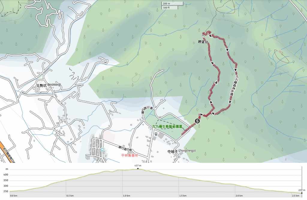
Distance: About 2.6km
Time: 1½-2 hours – We walked it in 90 minutes at a very comfortable pace.
Difficulty (regular Taiwan hiker): 2-3/10 – Depending on the heat, humidity, and direction, this is either an easy leg-burner or a moderately easy leg burner for regular hikers in Taiwan.
Difficulty (new Taiwan hiker): 4-5/10 – For someone new to hiking in Taiwan, this would either be on the harder end of easy or easier end of moderate in terms of difficulty.
Total ascent: About 200 metres.
Water: We took about 0.8L each on a warm October day and that was ample.
Shade: Parts are quite exposed. I had a hat with a neck cover and long sleeves.
Mobile network: Mobile coverage is adequate throughout.
Enjoyment: There are some great views here. I think walking in the opposite direction would have given us more opportunities to enjoy them though.
Other: Your feelings towards steps should impact how you choose to walk. If you hate climbing up steps, but don’t mind coming down them, then you should do an anticlockwise loop, but if your knees protest at descending steps, then you should do the same as us and follow a clockwise path. (Unfortunately, there’s no avoiding the steps altogether.)
Bathroom facilities: Only portaloos when we visited, but there was a whole park complex with toilets and a cafe being built, so there will be soon.
Route type: Loop
Permit: None needed
Jump to the bottom of this post for a trail map and GPX file.

The current starting point of the trail is a little messy due to construction work on a new park. We began our walk by trundling up the lane beside some portaloos and the site entrance.


After a couple of hundred metres, a signpost directed us to take a sharp, 90-degree bend to the right.


Another hundred metres down the track, we came to a junction. On the left, there are steps leading straight up to the viewing platform, and on the right, a slippery agricultural track takes a more circuitous (but gentle) route to the top. Much to Teresa’s displeasure, I chose to take the steps (I would have been happy going the other way too, but my dear wife did not voice her displeasure until we about two-thirds of the way up).

Some pretty colours on a fallen leaf.


A tree gateway on the left and one of the trail’s seven digital gemstones on the right.

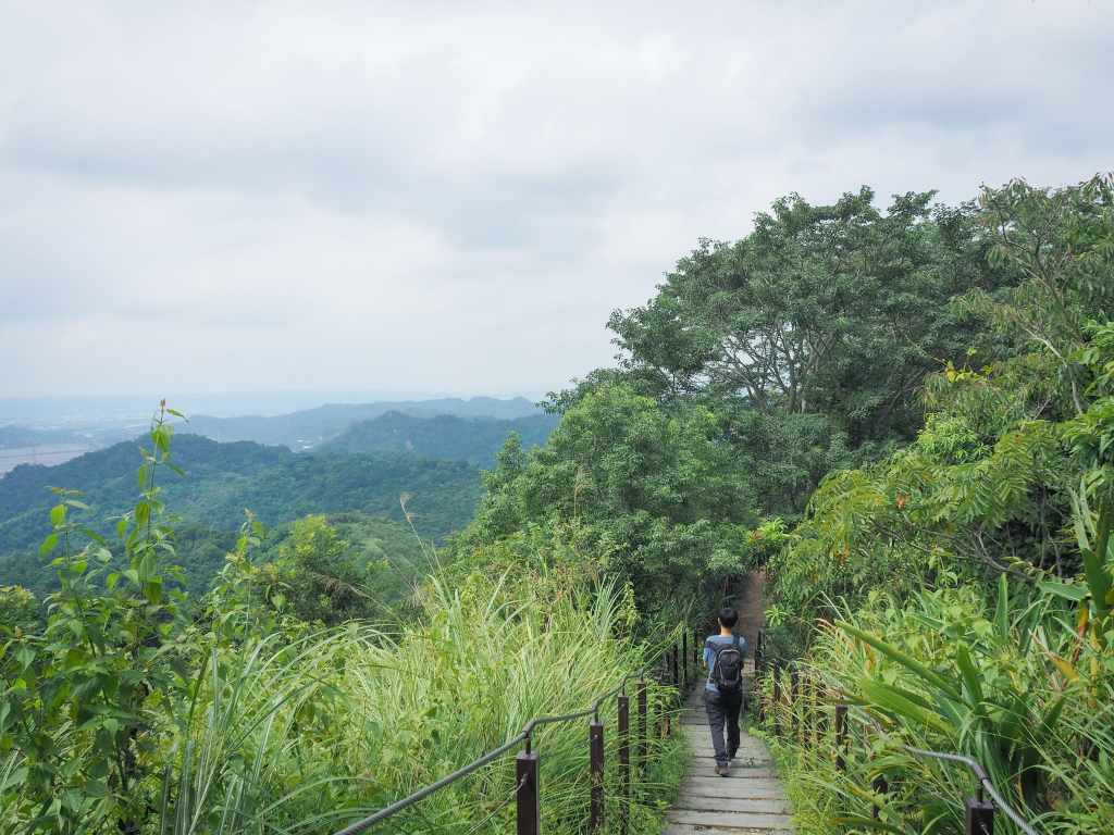
The trail up to the viewing point is almost entirely steps.


Pausing to catch my breath gave me the chance to appreciate the scenery. The hills here are comprised of loose sandy gravel along with a whole load of larger fist/coconut-sized pebbles. This makes especially prone to landslides during heavy rains and when viewed from a distance, the landscape of the hills where 99 Peaks Forest Trail is located is said to resemble a citadel of 99 towering peaks. The hills over on the far side of the river valley are similar, albeit not quite so dramatic in their formation.

At times, the steps are built directly into the earth, at others, a wooden walkway rises above the ground.

I think it would probably be a good idea to walk this in an anticlockwise direction if only for the fact that it would enable you to enjoy walking towards the views for most of the time.

At the highest point on the trail, there is a platform with a shelter on one edge. From up here, you can look out in the direction of Caotun and the low ridge line separating the coastal plains from the built up areas around Nantou.


The trail continues by heading straight over the far side of the platform and it is (literally) all downhill from there.


After just a few hundred metres, the steps gave way to a slippery-surfaced road and we found ourselves surrounded by thousands of these teeny tiny butterflies. The iNaturalist app thinks they are members of the Megisba genus. Being the sweaty Betty that I am, the butterflies gravitated towards me as a friendly moving source of nutrients. This little one here stayed on me for a couple of minutes, not even flying away when I started walking.

We made our way downhill with slow, deliberate steps, trying not to emulate the family that was keeping pace with us (almost of of whom had ended up doing some unplanned sitting down after their feet slid out from under them). At a couple of points, we heard monkeys, and even caught sight of several glowering at us through the trees.

As we neared the junction where we rejoined our path from earlier, we had one final trail friend in the form of an elegant five-lined skink, and then we were back at the car again.
How to get to 99 Peaks Forest Trail
Google Maps address: When we visited, there was roadside parking for cars and scooters right next to the start of the trail, but by the time this is published, there’s a high chance that the official carpark will have been completed.
GPS location: N23 59.590 E120 46.180
Public transport: The easiest way to get here on public transport would be to take the 6268A bus from Taichung Train Station (Chenggong Road Intersection). There are 10 services a day in each direction and the journey takes about an hour and a quarter. You will need to alight at Pinglin and walk an extra 15 minutes to the trailhead.
Further reading: Some Chinese information can be found here.
Nearby trails:
99 Peaks Forest Trail Map
GPX file available here on Outdoor Active. (Account needed, but the free one works just fine.)

What a beautiful trail!
LikeLike