
Smangus is a small mountain village inhabited exclusively by members of the Atayal indigenous group (also known as Tayal or Tayan). Since the early 2000s, it has been run communally, with the vast majority of the tribe’s residents taking turns to staff the kitchens, clean rooms, maintain trails, work in the farm plots, or perform whatever other tasks need doing. In return, they get a basic salary and have other needs such as healthcare and education covered by group coffers. If you’re interested in the village, you can find more about it here in an article I wrote on the subject for Travel in Taiwan Magazine.
The giant tree trail is the most popular of the trails that can be found around the village. It is also rated as one of Taiwan’s top 100 trails by users of the Hiking Biji App (which means that, if you’re so inclined, you can collect digital gemstones for it as you go).
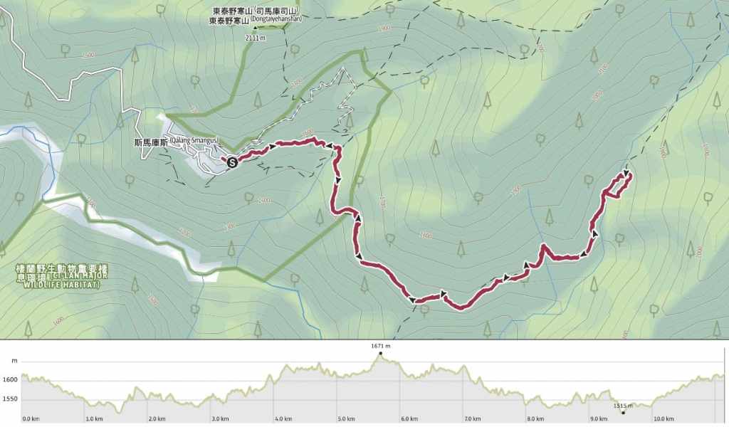
DISTANCE: A little over 11 kilometres.
TIME: 5-6 hours. We walked it in 5 and a half hours.
TOTAL ASCENT: About 450 metres.
DIFFICULTY (REGULAR TAIWAN HIKERS): 3-4/10 – The length, slight elevation gain, and logistical challenge of getting here place this on the upper end of easy for a regular hiker in Taiwan.
DIFFICULTY (NEW HIKERS): 5-6/10 – For those new to Taiwan hiking trails, this would be a moderately difficult hike, thanks in no small part to how remote the starting point is. The path is easy to follow and has a gradual incline, but that can be somewhat challenging over the whole distance.
SIGNAGE: There isn’t much signage on this trail, but given that it’s pretty much just one way out and one way back, you can’t go wrong.
FOOD AND WATER: I drank about 0.8L and didn’t need any snacks because we walked straight after having lunch and right before dinner. However, if you’re in need of supplies, you can pick up drinks and snacks at the store by the trailhead. Unfortunately, Smangus doesn’t seem to have any water dispensers save for those at the drinks table at meal times.
SHADE: Shade is dappled, so if you have sun-sensitive skin, you’ll want to cover up.
MOBILE NETWORK: A little patchy in places.
ENJOYMENT: The grove of giant trees at the end of the path is the highlight of this trail. Some of these trees have been here for thousands of years, so it is quite the humbling experience to stand in their presence.
SOLO HIKE-ABILITY: I’d be happy doing this walk solo. The route is easy to follow and there’s nothing particularly dangerous or challenging about the trail.
OTHER RISK FACTORS and CONSIDERATIONS: The trail sits at an elevation of 1,500-1,600ish metres, so you can expect the temperature to be significantly cooler in the shade than it is in the city. There was one short section that cut across an old landslide, but than that, it’s a pretty safe and straightforward walk.
ROUTE TYPE: There and back.
PERMIT: None needed for most of the year, but during the busy February to March blossom season, visits to Smangus are limited to those who have applied for a permit from the village’s tribal authorities.
Jump to the bottom of this post for a trail map and GPX file.
DIRECTIONS:

The walk starts close to a toilet block and the village restaurant and store. We walked the trail in the afternoon, so the store was open, but if you go in the morning after staying the night, it might by not be, so make sure you’ve prepared any supplies you want before leaving.

Just as we were about to set off, this wild boar came trotting into the village with a canine companion. The dog just stood at the edge of the trail, but the boar saw water and immediately plopped itself down, forcing the seated humans to dodge out of its way as it rolled.

The first 300 metres of the path isn’t technically counted as part of the giant tree trail…

The official start is here. A sign above the trail gives its name in Chinese and in Atayal, and shows a stick figure walking towards what can only be a depiction of Yaya, the largest tree in the grove.


Initially, the trail takes you through a tunnel of tall makino bamboo. Bamboo tends to dominate any landscape it occupies, often both visually and aurally, and the overall effect is quite impressive. You can see and hear nothing but bamboo all around.

If you weren’t looking for it, you’d miss this junction. The trail to the giant trees continues straight ahead, but a side trail on the right leads down to a waterfall. (If you want to visit the waterfall, you’d be better off doing so on the way back because it can be done as an alternative return route to the village.)


The path takes you over several stream beds, some with water, some without. If you look carefully when you’re crossing the bridges, you can usually see where the original trail went. One member of our party had been before and according to him, the route used to be a lot more up-and-downy.

Another patch of bamboo. (This photo serves no purpose save for the fact that I can’t get enough of have bamboo forests look.)


Looking down, there’s always something to look at and enjoy, like these tiny alder cones and delightfully feather fern shadows.

A Taiwan striped squirrel (a local subspecies of Tamiops maritimus). They’re quite a bit smaller than a regular squirrel, more chipmunk-sized. We saw several of these throughout the course of the walk and I really enjoyed watching their acrobatic antics. They seemed able to defy gravity as they jumped and scurried along whichever surface of the tree they fancied.

This is the first of two on-trail toilet blocks that you’ll find along the way.

I was honestly very disappointed that I didn’t need to loo, because each of the loos has a huge panel window overlooking the valley below, and how cool is it to be able to do your business as you enjoy the scenery?!

An old landslide scar has cleared away the trees on one area, giving walkers the best view of the whole trail. That said, the trees haven’t yet grown back uphill either, which means there’s not much holding the loose rocks in place, and you probably should pass through quickly.

In one area, the villagers have planted a cherry orchard (for the blossom, not for the fruit). It was April when we visited, so the trees bore fruit in all degrees of ripeness, but I bet it’s spectacular in blossom season.


A new-looking rest area and the second toilet block.

As we neared the giant tree grove, an opening on the right side of the trail gave a clear view over to the far side of the valley. There too, stand numerous giant trees.

Spotting the stream slightly down slope is the next sign that you’ve almost reached the giant trees.

The trail reaches a clearing where it splits in two to complete a loop. Signs pointing right indicate that walkers should take an anticlockwise route.


In the presence of water, the plant life has really stepped it up a little and everywhere is bright, bright green.


A wooden bridge takes you over a stream, and if you look down, the water is so blue that it looks as if someone has dumped food colouring in there.

The trail leading here from the village used to be an old hunting route, and in the past, hunters used to utilise the cooling properties of the water to keep whatever they caught fresh before they returned to the village.

Heading onwards, the path follows a raised walkway. Signs say that villagers took advantage of the quietness and lack of visitors during the pandemic to construct it.

Numerous large and giant trees beside the trail have been given names in the Atayal language, each of which is displayed on a sign.


The walkway climbs up to loop around the largest of the trees.

Most of the giant trees I had seen before tend to be large in all dimensions, but what was strange about this grove was that many of the giants were broad but skinny. This specimen, for example, looks to have a huge trunk from this angle, but once you stand in front of it, you’ll see the width is just a fifth of what you can see from the side here.

The trail hooks around the top of Yaya, the grandest of all the trees here.
She’s a Formosan red cypress that’s well over 2,000 years old and she has the most exquisite figure. It really is conceivable that when dusk falls, she gets up and walks around.


More ferns and a floating (dead) moth in a stream pool that we passed on the way back to the start of the loop.

Returning to the clearing, we decided to try and pick up the pace in order to not get caught in the hills after dark. Thankfully, heading back was mostly gently downhill, so it was a bit easier than the outward journey had been.

Lovely hazy late-afternoon views.


We also saw a fair amount of wildlife. There were more striped squirrels, several muntjacs, a Swinhoe’s pheasant, and a hard-to-spot frog.
We made good time heading back, and arrived at the trailhead early enough to go and get ourselves settled into our rooms for the night before heading back to the restaurant for dinner.
Getting to the Smangus Giant Trees
Google Maps address: The walk starts from outside the Smangus restaurant and store. There’s no public transport here, so you’ll need to either drive here yourself or hire a driver. The drive is pretty long (and not all that pleasant), so I would advise booking an overnight stay.
Staying at Smangus: There are several accommodation options, all of which can be booked via the tribe’s communal enterprise, Tnunan Smangus. Room rates can be found on the village’s website, but bookings must be made by calling 03-5847688. The site also has the menu and prices for the restaurant, which—given its remote location—works on an almost exclusively advanced reservation basis.
GPS location: N24 34.650 E121 20.260
Nearby Trails:
- Cinsbu Giant Trees
- Smangus Lookout and Koraw Ecological Park
Further reading: I wrote about Smangus and the wider Jianshi Township for Travel in Taiwan Magazine. That article can be seen here.
Smangus Giant Tree Trail Map
GPX file available here on Outdoor Active. (Account needed, but the free one works just fine.)
