MSTW SECTIONS 12-14
Day four on the MSTW was a long day for me, and the only day that I encountered rain. After breakfasting at Zengwen Youth Activity Centre, I set off along the road towards Dapu. If the water level of the reservoir permits, you can theoretically take a boat from the wharf in front of the viewing tower and enjoy a leisurely sightseeing trip around the reservoir before disembarking at Dapu Lovers’ Pier. I say theoretically because in recent years, Zengwen Reservoir has been pretty empty, and even though it was full(ish) on my visit, the staff at Zengwen Youth Activity Centre told me the boat was only a there-and-back journey, not a point to point. In retrospect, I should have checked with the staff in the viewing tower, but I didn’t think to. This day concludes in the town of Dapu, at least some of which was relocated here brick-by-brick (or pole-by-pole) when the valley was flooded to form the reservoir.
MSTW PASSPORT STAMPS: If (like me) you don’t arrive at Dapu before the visitor centre closes, then none. If you arrive before 5pm, you can head to Dapu Visitor Information Station to collect the Siraya stamp.
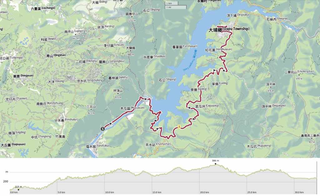
DISTANCE: 32.3 kilometres including the extra distance between the trail and accommodation at each end.
TIME: A little over eight hours.
TOTAL ASCENT: Almost 600 metres with close to 500 of elevation loss.
DIFFICULTY CONSIDERATIONS: Taken a kilometre at a time, this is some of the easiest walking you can do. The whole day follows roads and the inclines are never very steep. However, 30-odd kilometres of road walking can wear down your legs even with the comfiest of shoes and a very light pack. I also encountered a few guard dogs along the Provincial Highway 3 portion of the day. They were loud and slightly aggressive, but I didn’t need to do anything except not turn my back on them and continue walking at a steady pace to come out unscathed.
FOOD, DRINKS & PIT STOPS: The place I stayed at included a breakfast buffet, so I stocked up there and set off with 1L of water. You can also pop into the 7-Eleven in the lobby of Cham Cham Hotel to get snacks if you need. Along the way, you can fill up your water bottle at the Eye of Zengwen Information Centre and Zengwen Reservoir Lookout. Both also sell coffee and the latter has a couple of very basic food options. Aside from that, you’ll find a shack selling a few bottled drinks close to Fengchuiling bus stop where the road from the reservoir joins Provincial Highway 3, and there was a guy selling water and a few not-so-appealing (to me) snacks in the carpark by Xixing Observation Deck. You have several options for dinner in Dapu, including a 7-Eleven.
TRAIL SURFACES: Well-surfaced road.
SHADE: Mostly quite exposed.
MOBILE NETWORK: Clear for the majority of the day.
SOLO HIKE-ABILITY: Fine as long as you’re confident in your dog-allaying capabilities.
Jump to the bottom of this post for a trail map, GPX file and all the other practicalities. Or, for a video version of this post narrated in real-time, you can watch this video.
DETAILS & DIRECTIONS:
I got up at 7 and headed to the canteen for breakfast. There were only two other guests in the massive circular room. Probably because it was such a quiet day, only some of the buffet items (fruit, congee, toast), had been laid out, and the rest (sweet potato, cabbage, and eggs with salted radish) were brought out to me.

08:34 – Taking my time over a sit-down breakfast meant that I was slower getting out than I’d anticipated, but the day ahead (though long) promised to be relatively easy. So, after dropping off my room key, I set off to retrace my steps back to where I’d left the trail the evening before.

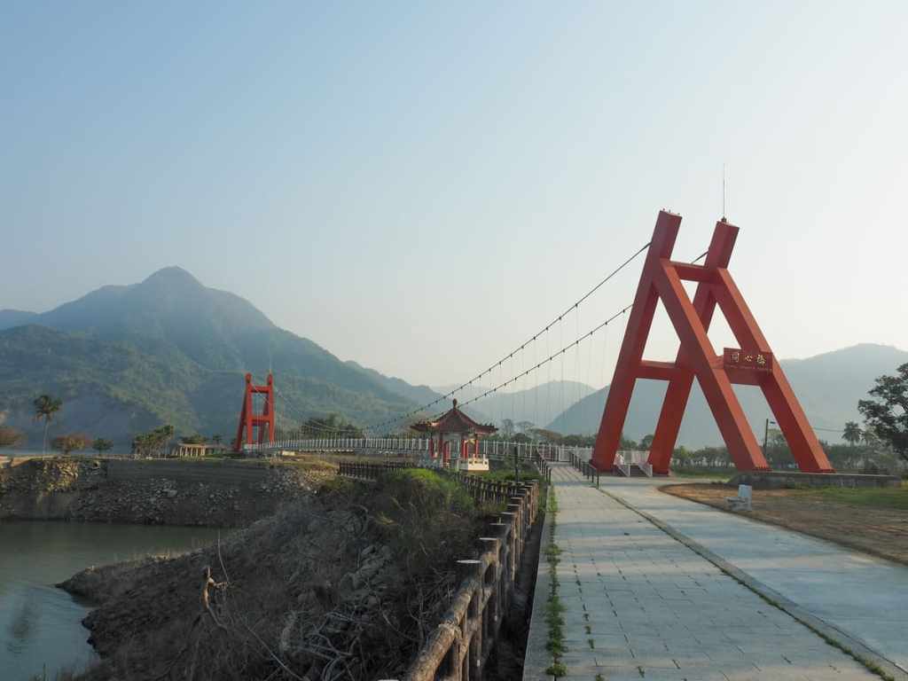
There is a nice view from the bridge, but beyond that, the road was rather dull. I provoked warning barks from some monkeys and was intrigued by the sounds made by pebble-carrying water as it plinked and clanged through a seemingly endless series of pipes.

09:34 – After an hour of walking, I reached the Eye of Zengwen Information Centre (曾文之眼遊客中心).

I paused to use their bathrooms, top up my water bottle, and fend off questions from the inquisitive uncle on the help desk.

09:49 – Occasional interest came in the form of construction work. Here, a viewing platform beside the road offers walkers a vantage point from which to observe the construction of a silt sluice gate. Information boards explain that this project came about in the aftermath of Typhoon Morakat-one of the most destructive typhoons to have visited Taiwan. As a result of the once-in-a-lifetime volume of rain that was dumped upstream, the reservoir became inundated with vast amounts of silt, which greatly reduced its capacity to hold water. The silt sluice gate is being built with the aim of reducing the downstream flood risk, as climate change makes extreme rain volume the new normal.

A little further up, another platform overlooks Zengwen Reservoir’s hydropower plant.

10:27 – The road runs up to meet the dam, and i finally managed to shake the noisy gravel trucks that had been shuttling up and down the road between here and the bridge back at the start. Here, you’ll find another toilet block beside a police station.

Walking over the dam, I watched a silt barge chug over towards the area that’s being dredged. I could also see the high water line way, way up above where the water actually was. During this visit, the reservoir was 53.7% full, but on my earlier pass through the area, it was a meagre 12% full and looked pitiful.

11:03 – After a couple of hours, I reached Zengwen Reservoir Lookout. The pier where boat tours of the reservoir set off is here too.

I wasn’t particularly hungry, but knowing this would be my last chance to have a coffee, I rode the lift up to check out the cafe. I ordered peanut butter toast to go with my coffee and enjoyed them as I watched the view and waited out a brief rain shower.

11:40 – Not long after leaving the visitor centre, I passed through Zengwen Reservoir Scenic Area’s gate/ticket booth. Walking in via the Wushanling Aqueduct Trail meant that I dodged the ticket fee of $100 per person, so I felt a little sneaky walking out through the gates so brazenly.


The road between the gate and the next junction was much quieter and I came face to face with a few animals. Looking up one side track, I saw a muntjac. The muntjac didn’t see me, but it sensed there was something wrong so it slunk its plump, silken body into the grasses and away. A few minutes later, I watched a Swinhoe’s pheasant glide gracefully to land in the middle of the road, only to immediately take off again in a flapping cluster when it realised it wasn’t alone.

12:27 – Where the side road leading into the reservoir scenic area joins the larger Provincial Highway 3, take a left turn and pass a roadside shack. The shack had a toilet at the back and a few drinks for sale, but food wise, the only offerings were baskets of pumpkins and green bananas.

It also had the world’s most useless guard dog—a little black puppy whose whole body wiggled in excited anticipation as I drew close. Unable to ignore such cuteness, I went over to say hello, but when the time came for me to leave, he cried up a heartbreaking storm.

A few minutes later, I met an older and wiser guard dog who was definitely not slacking off. Although it was obviously wary of me, it hunkered down, eyes trained on me, slinking forward if I took my eyes off it for a fraction of a second and barking to let me know it meant business. I had to walk backward and stand my ground as it rushed me, and it followed me down the road for about 200 metres before decided it had seen me off its patch. In fact, I met a few guard dogs along the road leading towards Dapu. None of them were too scary, but they let me know they really did not want me to linger in their territory.


I can’t lie. This part of the walk dragged. My feet were sore from all the road, and I cursed myself for being such a pedant as I turned down the third, fourth, fifth, sixth offers of a ride. However, cheer came in the form of occasional glimpses of pretty views, observing all the interesting seed pods, leaves, and roadkill that I passed, and from the countless waves, thumbs up, tooted horns, and 加油s yelled at me from passing scooters.

13:54 – At Xixing Observation Deck (西興觀景台), I paused to use the facilities, wolf down a couple of tofu cubes, and get some water from the guy parked up in the carpark. It’s the first water I’ve paid for so far. Up until now, I’ve got by with just filling it up at temple and rest stops. (Now I’ve finished the walk, I can say it was the only bottle of water I needed to buy.)

Even if you don’t actually need the bathroom, you can admire the view. I imagine it’s impressive at sunset.


More road, more small details to distract myself. Actually, this grasshopper wasn’t small. It was HUGE— maybe 8 or 9 centimetres. I’m not sure what it was doing on the road like this. Perhaps absorbing heat from the tarmac. As for the smashed bowls, that’s another mystery. They were in the middle of nowhere, just sitting there.

14:59 – My first sighting of Dapu. It felt both close and simultaneously painfully far.

Papaya farms in the late afternoon sun.

16:33 – I turned left off Provincial Highway 3 following signs to downtown Dapu. From there, it was another ten-minute walk to where I spent the night.


My hotel had the cutest pair of trainee greeters.


Although the hotel was big, I think I was probably the only guest that night, and after taking a quick shower, I dumped my clothes in the spin dryer, hung them up, and borrowed one of the hotel’s bikes to go in search of food.


The first course was stinking tofu from a woman who said she’s lived here her whole life. She mentioned that she lives in the little village to the east of Dapu, which consists of a couple of rows of houses that were carried up from their original position on what’s now the lakebed of the reservoir before the land was intentionally flooded in 1973. As I ate my tofu, I watched a trio of unhelmeted and grinning teens ride a scooter down the main street with their three fishing rods jutting out at odd angles.
Dinner number one done, I then went in search of the second course at 7-Eleven and cycled slowly through the gathering dusk to my hotel.
GETTING THERE
GPS location:
- Start point – N23 13.760 E120 30.120
- End point – N23 17.685 E120 35.745
Accommodation:
Staying in Zengwen – This was the single most expensive night of my trip, but there really are few options in this area. I am pretty sure you could also camp here if you have a tent, but if camping is an option, then you might as well just find a spot to wild camp (it would have to be before leaving the trail because I think the land after the trail is privately managed). The room was very comfortable though, and breakfast was included.
- Name in Chinese: 救國團曾文青年活動中心
- Name in English: Zengwen Youth Activity Center
- Address: 715台南市楠西區曾文青年活動中心
- Contact: 065753431
- Cost: $2,025 for a twin room (I got a small discount for booking via booking.com)
- Booking methods: booking.com, telephone
- Clothes drying facilities: There is a spin dryer but it’s not obvious. I needed to ask and then I needed to jiggle the cables a little to get it working.
Staying in Dapu – There are quite a few choices in Dapu, including the large and popular free campsite. I opted for this hotel because when I called to check, the boss was very enthused about the MSTW and that gave me a good feeling. The interior of the building looks slightly antique, but the room was spotless and extremely comfortable. As a bonus, they also have bikes that you can borrow to cycle into town.
- Name in Chinese: 大埔山莊
- Name in English: Dapu Lodge
- Address: 嘉義縣大埔鄉200號之1
- Contact: 052521089
- Cost: $1,300 for a double room (I ended up paying $100 less because they couldn’t offer me a vegetarian breakfast)
- Booking methods: telephone, Facebook
- Clothes drying facilities: There is a spin dryer and a drying rack to hang your clothes on out the back
MOUNTAINS TO SEA GREENWAY DAY 4 TRAIL MAP
GPX file available here on Outdoor Active. (Account needed, but the free one works just fine.)

This looks very interesting. I like a day of road walking. But what is the MSTW? Have you written about it somewhere else?
LikeLiked by 1 person
I haven’t written a homepage for this particular walk yet but I plan to. It’s a 188-kilometre trail that goes from Tainan to the top of Jade Mountain. I’ve written about days 1-4 over the past few months (those can be found in the blog section of the site), and days 5-11 will be published over the coming months.
This is a map of the route: https://www.google.com/maps/d/u/0/edit?mid=1krNeMkiu1ljdCBKDsRvynkmf5HjL3Xc&usp=sharing
If you like road walking, you might also enjoy parts of the Raknus Selu. That has a lot of road walking through Hakka areas.
LikeLike