MSTW SECTIONS 08-12
Day three on the MSTW was my first day of walking after two days of cycling, and it was lovely to get back to what I’m most familiar with. I was eased into it with a long and increasingly steep climb up orchard-lined roads before following in the route taken by Hatta Yoichi and his team of engineers as they planned out how to transport water from Zengwen Reservoir to the dry plains below. I ended the day with a 7-Eleven dinner and a very comfortable suite at Zengwen Youth Activity Centre.
MSTW PASSPORT STAMPS: There’s 1 stamp to collect along this part of the walk at Xikou Little Switzerland (西口小瑞士). The stamp is kept in a box beside the road and is accessible 24 hours a day, 7 days a week.
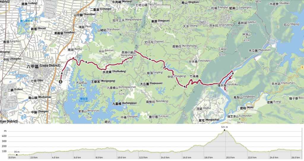
DISTANCE: 27 kilometres, including the extra distance from where I left the MSTW to walk to my accommodation.
TIME: 8.5 hours – This included an unrushed stop at Xikou Little Switzerland for lunch, and as with the rest of this journey, I went at a speed that enabled me to enjoy my surroundings.
TOTAL ASCENT: Almost 700 metres (and about 600 metres of descent, too). Most of this is done in one big push on the Wushanling Hydraulic Historic Trail portion of the walk.
DIFFICULTY CONSIDERATIONS: The walking is pretty straightforward, but in strong sun, the climb would be excruciating. Aside from that, the main challenge is the length. The fact that the majority of this day follows roads means that 27 kilometres is very doable, but it also means that you’ll want shoes with well-cushioned soles. Travelling on rural roads like this also means there is a chance you’ll meet farm dogs. I only encountered noisy dogs, no aggressive ones.
FOOD, DRINKS & PIT STOPS: There are very, very few places to get food or water along the way. I set off with breakfast (purchased the day before in Liujia) and stopped for lunch at 西口小瑞士湖光水舍-景觀餐廳, a small waterside cafe overlooking the water funnel at Xikou Little Switzerland. While I was there, I also filled up my water bottle from their water jug. The sign says that it is open from 10am to 7pm (weekdays) or 8pm (weekends). This is the only place to stop between here and where the day’s walking ends. NOTE: This restaurant is no longer in business. At the Zengwen side, I think you should be able to top up your bottle at Dongkou Workstation if you ask politely. And for dinner, if you plan to stay in the same place as me, you can purchase a set meal from them for a small extra fee ($180), or you can visit the tiny 7-Eleven in the lobby of Cham Cham Hotel. Zengwen Youth Activity Centre also has a small shop selling instant noodles and crackers, and it has water dispensers evereywhere.
TRAIL SURFACES: About 4 kilometres of farm track or trail, and the rest is well-surfaced road.
SHADE: Only part of the trail section is shady, the rest is pretty exposed.
MOBILE NETWORK: A little patchy in parts, but generally OK.
SOLO HIKE-ABILITY: There’s nothing about this stretch of trail that makes it unsuitable for solo walking. When I first came to Taiwan, I think I might have been a little hesitant to walk backroads like this alone, but actually it’s fine.
Jump to the bottom of this post for a trail map, GPX file and all the other practicalities. Or, for a video version of this post narrated in real-time, you can watch this video.
DETAILS & DIRECTIONS:
Lü Dongbing, it transpired, had nothing to say to me. What’s more, I had forgotten both the extreme potency of the caffeine in Taiwanese tea and the fact that altar lights don’t get turned off at night, so I spent a sleepless night trying and failing to sleep.

Lack of sleep notwithstanding, I had promised to be up at seven to be photographed with Mr Lin before setting off. I looked and felt like shit as I smiled through what morphed from a photo to a video interview, but was very grateful that I’d been so welcomed and that Mr Lin had and Ms Liu had given me so much of their time. I was also photographed taking a lucky token from the friendly woman who’d helped me check in the day before, and I was sent off on my way, (being filmed) with a peach and some offerings left over from Dijun Wenchang’s birthday celebrations for my breakfast.


08:03 – From the temple, I turned right onto Gongyan Road and began my walking with a bun in one hand and a coffee in the other.

Barely ten minutes had passed before my three chamber-mates from the night before rode past and very sweetly asked me if I’d like “a lift to the start”. I thanked them by said I’d prefer to walk, and they waved me on my way.

08:27 – After about twenty minutes, I passed the turn-off for the Industry Technology Research Institute Foundation. This is where the reflexologist from last night works. I think someone said he’s an engineer but I’m not too clear. Perhaps he is studying the technological advancements of foot massages. Then another five minutes later, I arrived at this junction. Here, the MSTW takes a right turn and begins to follow City Highway 174 up in the general direction of Zengwen Reservoir. While we’re on the subject of Zengwen Reservoir (曾文水庫), you will encounter several different spellings of the name as you pass through. Tsengwen is pretty common, and a lot of the signs I saw said Zengwun.


Immediately after turning right, you’ll find yourself walking along Tainan Second Prison, the walls of which are somewhat incongruously painted with murals of cats, books, and this cute character.

What follows is a whole lot of walking up, (and some walking down) along the road. Partway up, there’s a rubbish processing facility, so until you pass that, you’ll see a fair few rubbish trucks. Otherwise, the main types of traffic are helmetless (and occasionally shoeless) scooter riders, and farmers either driving blue trucks or chugging along on those tiny little red farm vehicles. More than once, I was genuinely afraid that I was about to cause an accident because a rider spent far too long staring at me.


Occasionally, there are small wayside temples. Some are dedicated to gods, others have been erected to honour the bones of the unknown dead.

The scenery is mostly scruffy farmland. There are areas of bamboo, some longan and lychee orchards, and some orange orchards too.


Both the lychee (left) and orange (right) trees were blooming and the air was perfumed with the exquisite scent of orange blossom. I think it’s up there with osmanthus as being one of my favourite floral scents.

At each big junction, there is subtle, but unmissable MSTW signage directing you onwards if you look for it.


Road, road, road, and more road.

10:55 – Finally, after following City Highway 174 for what seemed like an age, I turned right onto a smaller road signposted as heading to Xikou Xiaoruishi (西口小瑞士).

11:03 – It was starting to get a bit warm by this point, and the only coffee shop along the way was calling me. After following the road down for a way, look out for signs directing you to the left. (After lunch, I came back to this spot and took the road continuing on.)

NOTE: This restaurant is no longer in business.
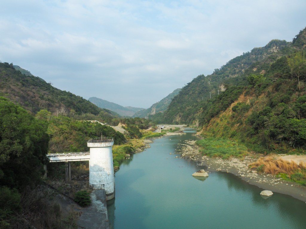
The coffee shop overlooks an interesting engineering feature, a whirlpool-esque entrance to a shaft where water plunges vertically before being funnelled into a channel that runs down to feed Wushantou Reservoir. Like the canals I’d been following the day before, this is the legacy of Hatta Yoichi. He needed to fill Washantou Reservoir with water so that his irrigation network could do its work, but to get the water there from Zengwen Reservoir higher up was a massive undertaking of which the Little Switzerland whirlpool is just a minor part. More impressive, was the 4-kilometre tunnel his workers cut straight through Wushan Ridge. The scale of the effort is hard to imagine.

I ordered cold coffee and udon noodles. I’ve clearly been in Taiwan too long, because it turned out that I really did not want the cold drink. Despite the heat, the hot and salty broth was precisely what my body needed. The place is so quiet—only the occasional scooter trundled along the nearby road. Otherwise, the soundtrack to my meal was the gentle sound of breeze-stirred branches, water, and the conversation of birds. Off in the distance, some bird with a clear and strident call sang out to a mate with no luck, an egret patrolled the water giving its best croaking shot at proving birds are the direct descendants of dinosaurs, and a pair of courting wagtails chased each other round the circular spillway. After sitting and being still for a while, it was clear I had walked myself out of the city.
As I was leaving, the store’s only other customer asked if I was doing a round-island walk, so I showed him the trail passport that I’d taken out in preparation for the nearby stamp. It turned out that he’d heard of the trail and was interested in doing it himself.

Leaving the coffee shop behind, I returned to the road and followed it through a small hamlet. In a clearing close to a sculpture of a firefly, you’ll find the next stamp. (It’s easy to miss. If you find yourself walking over the dam, you’ve missed it.)

12:17 – This one shows the whirlpool water feature. As to why this place is known as Little Switzerland, apparently, in the past, the valley’s secluded beauty led to people seeing a similarity between it and Switzerland. Personally, I’m not sure, but by all accounts, when water levels were reliably higher, it really was very beautiful.


As I was climbing up a bamboo-lined road, the other customer from the cafe rode up to make sure I had someone in the area who could help if I needed it and to ask if we could take a photo together. I consented, and I got another reciprocal photo to add to my collection. (If you look visibly foreign, it is not especially uncommon to be asked to have your photo taken. Rather than getting annoyed by it, I have decided to try and see how many such photos I can collect.)

The road continues to climb and climb and climb through an area entirely given over to fruit trees. At a farm surrounded by longan trees, I got accosted by a grandma and her short-legged mongrel whose barking belied its dachshund heritage. After her repeated attempts to ask me something I couldn’t understand, I whipped out one of the handful of Taiwanese phrases I know that do not include swearing: “góa khì peh suann,” and that elicited a smile and a confirmatory “oh, you’re hiking!”

13:15 – At the junction, I turned left onto City Highway 175.

A sofa that has seen better days.

13:25 – I was only on the 175 for about ten minutes before I spotted the turn-off on the right for Wushanling Aqueduct Historic Trail. It seems like the veracity of the story has been lost to history, but some historians say that this trail was the route Hatta Yoichi and his team took when surveying for the construction of the tunnel that cuts through this very ridge.

One of the many longan processing facilities you’ll pass on the way up.


The last time I was here, it was the middle of the longyan picking season and the picking and packing operations were in full swing.

Earlier, I had thought the ridge didn’t look too high or too far. I was wrong. It felt farther and higher than it looked. As Miaoli’s plains shivered in the coldest temperatures recorded, I was sweltering under the Tainan sun, and the heat sapped the energy from my legs. Because of this, I found myself pausing often to look at the far-off view or the close-up details.

During one such pause, I was rewarded by spotting this lychee stink bug laying her blue eggs on the bark of one tree (not a lychee tree). Another pause rewarded me with a sighting of a massive hawk perched on an electricity pole further up. As I watched, it took to the wing and soared off in search of food.

A couple of the buildings I passed housed facilities like this for preserving longans using heat and smoke. I’ve tried them preserved in this way once before. I was not a fan.

14:07 – Finally, the track reaches the ridge and takes a left turn. I thought this was the end of the climb, but alas, it wasn’t quite.

14:18 – That came just a little later when I reached this clearing with a triangulation marker and lots of benches. With tired legs, I paused here for some snacks before beginning the descent.

The path down was entirely unlike the path up. There were no more farms, just the odd errant longyan tree scattered among the bamboo-maybe brought here by one of the monkeys that roam the area. I had to change my walking style to cope with the steep, leaf-littered descent. The dry leaves were so slippery.

14:48 – The first view I’d had of the Zengwen Reservoir Valley. I hadn’t realised it at the time, but the place I would be spending the night was visible just to the right of the centre, above the gate that makes the eastern entrance to the water channel through Wushan Ridge.


The path alternates between these steps and flatter sections of loose gravel hemmed in by wooden barriers. Either way, you can’t afford to take your eyes off your feet in case you misstep. More than once, I sent muntjacs scrambling away down the slopes. The ones far enough to be merely disgruntled by my presence and not as terrified scolded me with their harsh barks, while the nearer ones scrabbled desperately through the undergrowth, sounding like something twice the size. I also heard one strange sound that might have been a sambar deer.


The further down into the valley you descend, the scruffier and less dense the trees become.

15:18 – At the junction, keep left following the signs to Dongkou (東口).

Something about this sign just feels kind of neat.

15:26 – There are four springing rope bridges to help hikers across ephemeral creek beds.

Near the second bridge, I came across the only other hikers I’d seen all day. When the realised I was behind them, they picked up their tiny Yorkshire terrier and let me pass.

Looking downstream along the Zengwen River Valley.

As you near the end of the trail, the path takes you past a tall mudstone slope.

15:38 — Before long, I found myself back on the road. From here, take a left turn and just keep following the road. After about ten minutes, I passed a toilet block. It looks like this might have been used for camping in the past, but not anymore.


16:05 – At the junction, the MSTW turns left, but this was where I left the trail for the day.

Instead, I turned right and made my way over the bridge to Tsengwen Youth Centre via the 7-Eleven in the lobby of Cham Cham Hotel.


16:38 – I feasted on my convenience store spoils, washed some of my clothes, showered and settled in in anticipation of a better night‘s sleep than the last two.
GETTING THERE
GPS location: It is still another 1.6 kilometres from the end point noted here to the place I spent the night.
- Start point – N23 13.250 E120 21.955
- End point – N23 13.760 E120 30.120
Accommodation:
Staying in Lijia – Despite not getting much sleep, I absolutely loved the chaos of the evening spent at this temple, and I’m really glad that I included a temple stay on this journey, it feels like an important part of Taiwan’s low-elevation multi-day hikes. If you’re not fussed about staying in “the god room,” you can always opt for one of the more standard beds. For help booking a room at Liujia Zhennan Temple, you can click here.
- Name in Chinese: 六甲鎮南宮
- Name in English: Liujia Zhennan Temple
- Address: 73445台南市六甲區工研路2號
- Contact: 066982464
- Cost: $600 for a cubicle in the Sleeping Fairy Dreamland
- Booking methods: telephone
- Clothes drying facilities: I think there was a spin dryer, but I didn’t use it
Staying in Zengwen – This was the single most expensive night of my trip, but there really are few options in this area. I am pretty sure you could also camp here if you have a tent, but if camping is an option, then you might as well just find a spot to wild camp (it would have to be before leaving the trail because I think the land after the trail is privately managed). The room was very comfortable though, and breakfast was included.
- Name in Chinese: 救國團曾文青年活動中心
- Name in English: Zengwen Youth Activity Center
- Address: 715台南市楠西區曾文青年活動中心
- Contact: 065753431
- Cost: $2,025 for a twin room (I got a small discount for booking via booking.com)
- Booking methods: booking.com, telephone
- Clothes drying facilities: There is a spin dryer but it’s not obvious. I needed to ask and then I needed to jiggle the cables a little to get it working.
MOUNTAINS TO SEA GREENWAY DAY 3 TRAIL MAP
GPX file available here on Outdoor Active. (Account needed, but the free one works just fine.)

I love your reports – hope so much to be back in Taiwan one day soon.
LikeLiked by 1 person
How long has it been now? If I recall correctly, you were here when I arrived — or at the very least, we had some overlap.
LikeLike
My last stay was in November 2019, just before the plague, when I was there for a month.
LikeLiked by 1 person
You must have saved up a big list of places to visit by now then.
LikeLike
Aye, but I didn’t do much hiking in Taiwan yet. Some Taroko, some Yangminshan, …
LikeLike
Aye – but so far I didnt do much hiking in Taiwan. Just some Taroko and Yangminshan.
LikeLiked by 1 person
All the more reason to come back and correct that omission! (You’re lucky you were able to experience Taroko. I don’t think anyone will be visiting that soon.)
LikeLike
Yeah, I hope the political status quo will remain for a while. I assume it was hit badly by the earthquake? Had indeed some great days in the gorge: https://flickr.com/photos/loeffle/tags/taroko
LikeLiked by 1 person
Yes, Taroko was badly hit. None of the tourist trails are open or will open any time soon.
LikeLiked by 1 person