This little trail was not at all on my radar before I walked it. In fact, the only reason I know it exists is because I just happened to ride past it and stop at the viewing platform on a long and circuitous ride down from Fenqihu to Mount Duli Hiking Trail. (County Road 166 isn’t the quickest way between these two spots, but it’s certainly scenic.) My impromptu stop was rewarded with this short but pretty walk.
Distance: 1.8 kilometres.
Time: A little under an hour.
Difficulty (regular Taiwan hiker): 1/ 10 – The trail is short and surfaced the whole way, so for those familiar with Taiwan hiking trails, it should be a walk in the park.
Difficulty (new Taiwan hiker): 3/10 — For those new to hiking in Taiwan, the steps might prove tiring, but that aside, it’s a very easy walk.
Total ascent: About 130 metres.
Water: A small 0.5L bottle should suffice. You can top up your water at the temple at the bottom of the trail.
Shade: Much of this trail is unshaded, so if you’re sun-shy, make sure you take protection.
Mobile network: Clear throughout.
Enjoyment: This is a perfectly pleasant trail with pretty views, but Chiayi is so spoiled for easy, pretty walks that this one doesn’t have anything to make it stand out.
Cherry blossom season: One part of this trail is lined with cherry blossom trees. These bloom around February time.
Bathroom facilities: You can find toilets by the temple at the bottom end of the trail
Route type: Lollipop loop.
Permit: None needed.
Jump to the bottom of this post for a trail map and GPX file.

A map and a small carpark with enough space for several vehicles marks the upper trailhead of Taixingyan Trail.


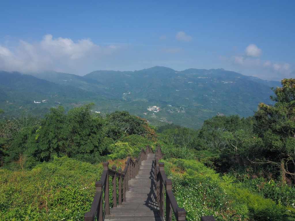
Walking down a short flight of steps will take you to a platform with expansive views over the landscape, with steeper, more densely wooded slopes to the east and clusters of tea plantations to the north. If you’re all about the views, then this is as good as it gets.

A raised boardwalk beckons you onwards and down in the direction of the tree line.

Right where the boardwalk ends to be replaced by concrete steps, there is a circular shelter which catches the light very prettily.

And even once the view is obscured by trees, the trail is still quite pretty.


The trail keeps descending steadily until it reaches this junction where another boardwalk joins from the right. Later, I would make a small loop to return via this side trail. If you continue to head straight along the main path, you’ll soon find yourself at the rear of a large(ish) temple.

Head through the gap beside the spirit money burner to reach the temple’s main forecourt.


Guanyin is the deity seated on the main altar in Taixingyan Temple (泰興巖). To either side you’ll spot Tudi Gong and Jinlong Bogong. And if you take a peek below the main altar, you’ll find the temple’s Huye (Tiger God). This one is cute and chubby with stripes that resemble waves, and buck teeth that look more rabbity than fearsome. The temple’s once-white walls are stained yellow with the residue of years and years of incense, but despite the aged appearance, this temple building is relatively new, having been built with the last decade or so. However, there has been a temple of this site for over two hundred years. It was first a simple bamboo construction made by Fujian settler Huang Genlong (黃根隆), who brought an idol over with him when he crossed the Taiwan Strait.
It seems the temple is more than strictly a temple. The courtyard in front of it is flanked to the left and right by two more buildings, one of which is a B&B which offers vegetarian meals and has very high reviews, and the other side is some sort of community space. On the day I visited, I happened to be there just as the people staffing a travelling mountain doctor’s truck were loading its cabinet of medicines back into the vehicle. I’d never seen this type of service before, but I guess it makes perfect sense. So many of these little mountain communities are populated with old folk who maybe can’t or aren’t keen to make the journey down to the city to visit a clinic. Taking the doctor to them seems like a neat compromise.


You can return back the same way you came, but if you turn right out of the temple then right again up this side road (it’s the second side road you’ll come to), you can make a short little loop.


The benefits of making a loop instead of returning the same way are twofold. Firstly, this trailhead is marked by two sets of twin shrines, which I found interesting, even without knowing much about them.

And secondly, the steps that’ll take you back up to the main trail are flanked with cherry trees, so if you come at the right time of year (maybe January or February), they will be abloom with bright pink cherry blossom.

Once you get to the top of the boardwalk, you’ll find yourself back at the trail you walked down on. Turn left here and after another 5-10 minutes, you’ll be right back at the start.
How to get to Taixingyan Trail
Google Maps address: I started from the trailhead on County Road 166, and there’s a second trailhead lower down. There is free parking available at both, but the lower carpark is bigger.
GPS location: N23 32.175 E120 38.110
Public transport: There is technically a bus which stops at the upper trailhead, the 110 Taiwan Tourist Shuttle service which runs between Chiayi Train Station and Ruitai. However, the bus only runs three times daily and the journey takes 2 hours, so I wouldn’t advise trekking up here unless you have other plans in the area.
Nearby trails:
Taixingyan Trail Map
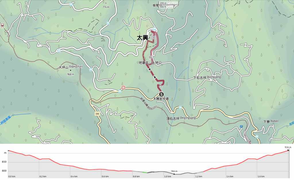
GPX file available here on Outdoor Active. (Account needed, but the free one works just fine.)
