
Jinmian Shan, Mount Jinmian, Goldside Mountain, or Scissors Rock — the goal of this trail has multiple English names, reflecting its popularity among hikers both local and from all over the world. Indeed, I think I am guilty of muddying the waters somewhat because I’ve referred to it by different names on various posts on this site. Whatever you want to call it, I personally think it is perhaps the best place to watch the sunrise in Taipei.
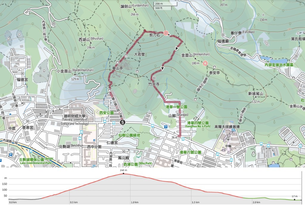
Distance: I did a 2.4km loop, but you could easily extend it.
Time: I started walking at 5:10am and finished at 7:00am. Included in that was a 30-minute stop at the top to watch the sun.
Total ascent: About 220 metres.
Difficulty (regular Taiwan hiker): 3/10 in the dark, less in daylight hours.
Difficulty (new Taiwan hiker): 5-6/10 – Getting here and finding your way up quite steep, rocky climb in the dark would be challenging, but definitely doable. Plenty of non-hikers do this as a sunset hike.
Risks and dangers: The trail is rocky, uneven, and unlit, so extra care is needed if you’re doing this pre-dawn. That said, there are very few places (save for right at the top) where you could fall.
Water: Pre-sunrise, you won’t need much. A single small bottle should suffice, but if you’ve got a thermos, why not consider bringing your morning coffee.
Shade: The top part is quite exposed, but that’s not going to matter if you’re catching the sunrise.
Mobile network: Clear throughout.
Enjoyment: I find it hard to rate this one. It’s in my backyard, so it’s become my regular stomping ground and I tend to come here for exercise more than anything else. That said, the city views never get old, and sunrise is the best time to enjoy them.
Bathroom facilities: There is a toilet block close to where I ended the trail.
Route type: Kind of a loop (or point-to-point). There are so many ways to walk this.
Permit: None needed.
Jump to the bottom of this post for a trail map and GPX file.


The walk starts at the end of a cul-de-sac. I remember the very first time I headed in here in the dark by myself, I was just a little bit terrified. If–like me–you’re a little scared of the dark, it might help to know that I normally only need my headlight for the first 10-15 minutes of the hike. After that, the path opens up and the sky is normally light enough to turn it off. Head up the steps keeping the water on your left. When you reach the pagoda, turn right then immediately left again up the steps following a sign directing you towards Lunjian pagoda (論劍亭).

The first stretch is all steps in a tunnel of trees. Normally, by the time I am walking this section, the dawn chorus is just getting underway, and my panting is accompanied by the cheerful sounds of birds waking up to greet a new day. Occasionally, I’ll spot feral cats loitering in the bushes here. The first time I saw one, the glow of its eyes in my headlights gave me a mighty fright. After climbing a long and straight-ish section of steps, the path veers right and comes to this junction. To the right. there’s a viewing platform where you can get your first city view (and catch your breath). Another 20-30 metres further along, there’s a second diversion to the left where you can see the remains of an old Qing dynasty quarry.


Keep pushing up the hill, and you’ll soon break free of the tree cover. Usually, it’s bright enough to see unaided at this point, and this day was no exception. Despite sunrise still being another 25 minutes away, the sky had started to redden and I could easily see where I was going.

There are three pavilions on the trail. The first one is this one lurking in the shadows to the left of this photo. Take the trail on the right and keep heading up.

The next pavilion is on the right and has a good view of the city. I didn’t get a photo of this one because it was occupied by someone doing their early morning calisthenics. (There is ALWAYS someone exercising here, no matter how early I go.)


At the next junction, take the trail on the left towards Lunjian Pagoda. (The righthand trail links up with Zhuyue Temple–where this walk ends.) The next part of the path is the toughest. It follows the jagged spine of the hill more-or-less all the way to the top. If you’ve never walked it before, your best bet is to stick to the fence on the righthand side. I usually head straight along the crest. If you look carefully, you’ll spot a path cut into the rock to make walking easier.


Right as you are about to reach the top, you’ll pass another clearing occupied by a two-storey pavilion and a gaggle of early-rising elderly folks. Seriously early-rising. I’ve been here not long after 4am before in midsummer, and they’re still here before me.

The predawn light had turned pallid by the time I arrived at the top. The deep red hues of earlier replaced by the kind of subtly beautiful and luminous pastels that just don’t come out in digital photos. It sometimes does this, and it feels like the sunrise is going to be underwhelming. But it rarely is.

On other occasions, the shadow of night’s darkness seems almost hesitant to leave, and the city remains cloaked in this beautiful sleepy blue. (This photo was taken in May a year before the rest of the photos here.)

On cloudy days, in the minutes just before the sun shows itself, it fringes their extremities with fire-bright gold and breathes a lick of red-pink into any clouds higher up in the sky.


Quite often, my sunrise viewing on this peak is interspersed with bird viewing. In particular, the area is popular with a flock of blue magpies and their grey treepie groupies. These birds really are a treat to watch.

Then when the sun starts to rise, it does so quickly and decisively. Of course it’s an illusion caused by the sun’s proximity to the horizon, but it really seems to move quicker at dawn.

In the times I’ve been here to enjoy this moment, sometimes I’m alone, other times there are fellow sun watchers. But without fail, they all disperse within a few moments of the sun appearing. Let me tell you. These fools are missing the very best bit. In the thirty minutes after the sun crests the horizon, the colours are constantly shifting. It’s an entirely free, entirely solar-powered, and utterly enthralling light show.


The sun casts the different layers of hills into stark contrast, painting their eastern slopes with light and leaving the western sides in shade. Turn around, and you can see it colouring the rocks the peak is named for with whatever shade of yellow/orange/red it has picked for the day.

If you stay long enough, you can watch the city waking up. Sometimes I see the first flight of the day leaving Songshan Airport. This early in the morning, you can distinguish the roar of each aircraft’s engine as it warms up. After another half an hour, the general hum of city traffic takes over.
On this most recent visit, the weather conditions were really rather unique. The entire sky was blanketed with an unbroken layer of clouds. These clouds stretched down to the horizon to the north, south and west. But in the east, there was this narrow clink. A small sliver between the clouds and the horizon where the sun could be seen. It created this rather magical effect where it looks like there is a thread of gold running through the middle of the picture. I’ve warmed the colours up a touch, but I haven’t fiddled with anything else. That’s what it looked like.

That’s one of the best things about resisting the same place. You get to see all of its faces. The above photo was taken a year or so earlier. The early morning mist, pastel hues, and promise of a blue sky later gave this day a far more dreamy feel.

Then there was this day when the sun rose almost directly behind Mount Keelung and bathed the sky in an ominous red glow. It’s like a lucky draw. You never know what type of sunrise you’re going to get.


When you’re done enjoying the show, you can either head back the same way, or take one of the many, many alternative routes which fan out from here. I decided to do a small loop, so I took the trail heading down past the largest of the rocks.


Head straight past the pylon (going left here takes you to Daitian Temple). Then a few minutes later, take a right towards Zhuyue Temple (heading straight will take you to the true peak of Jinmian Shan and over the hills towards Wende).

At the bottom of the descent, the trail crosses over a small stream and passes an area of farmland. In the spring and early summer, the stream pool here is full of little tadpoles.


The path curves around the rear of Zhuyue Temple. There are two paths you can follow here. Take the steps heading downhill (it’s signposted as going to Huanshan Road). There’s a toilet block here and there used to be water too, but the machine was turned off because of the pandemic and has not been turned back on again.


The steps end at a Buddhist temple (the one on the left with a pot of water left out for travellers to drink, it doesn’t really look much like a temple). From there, follow the road as it curves towards a playground, then heads straight again down to Huanshan Road. Once you get to the main road, you can turn right to walk back to where you started (this should take maybe 10 minutes), or keep going straightish until you reach Gangqian MRT Station.

A pre-breakfast hike deserves suitable post-hike refuelling. I got myself ready for the rest of the day with a bowl of hot soy milk and a hash brown danbing from my favourite soy milk shop in the area.
How to get to the Jinmian Shan Trail
Google Maps address: This trail starts from this park at the end of Lane 136 just off of Huanshan Road. There are many possible ways to finish the walk, but I came down via the trail that exits by Zhuyue Temple.
GPS location:
- Lane 136 trailhead – N25 05.315 E121 34.080
- Zhuyue Temple trailead – N25 05.295 E121 34.340
Public transport: There are bus stops close to both trail heads, but it’s also just a ten minute walk from Xihu MRT Station to the starting point, and a similar walk from the end point to Gangqian MRT Station (both on the brown line). However, you’ll need your own transport if you want to see the sunrise.
Further reading: I’ve visited this spot at several times on this site. There’s a night hike visit, and an extended route from Jiantan to Wende.
Nearby trails:
Jinmian Shan Trail Map
GPX file available here on Outdoor Active. (Account needed, but the free one works just fine.)

The second Chinese character should be 面, so it’s not 金門山 but 金面山.
LikeLiked by 1 person
I absolutely know that. What an idiot! Thank you for pointing that out.
LikeLike