
A Short Hike with Outsized Views
I had previously visited Mount Jiangziliao on one leg of my Taipei Skyline Trail adventures. On that visit, I hiked up from Xiping Road, battling through grasses so tall that they towered above me and being screeched at by perturbed muntjacs. This walk is nothing like that. It is short, easy, and you still get rewarded with panoramic views and another of Taiwan’s 100 Minor Peaks in the bag.
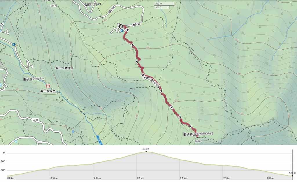
DISTANCE: About 3.3km.
TIME: 1-2 hours. We spent a little under an hour and a half here.
TOTAL ASCENT: Just shy of 300 metres.
DIFFICULTY (REGULAR TAIWAN HIKERS): 1.5/10 – Lots of steps in both directions but because of the size and placement, they’re not as tiring as some steps.
DIFFICULTY (NEW HIKERS): 2-3/10 – As above, there are plenty of steps, and those can be a shock to the system if you’re new to hiking in Taiwan, but that aside, it’s easy. The trail is well-maintained, one way up, one way down and easy to navigate. However, getting there may present a challenge.
SIGNAGE: Pretty clear throughout.
FOOD AND WATER: We took 0.5L each and that was sufficient on a pleasant September afternoon.
SHADE: Quite shady until you reach the top at which point it becomes completely exposed.
MOBILE NETWORK: Clear throughout.
ENJOYMENT: This was a pleasantly short walk with some awesome views at the top. If I lived closer, it would for sure be one of my regular exercise trails.
SOLO HIKE-ABILITY: This is a very suitable walk to do solo.
TAIWAN 100 MINOR PEAKS: Number 11, Mount Jiangziliao
ROUTE TYPE: There and back.
PERMIT: None needed.
Jump to the bottom of this post for a trail map and GPX file.
DIRECTIONS:

The walk starts from a split-level carpark at the top of a winding rural lane.

Where the concrete runs out a the path begins, there’s a basket full of hiking sticks for people to use and return.

Actually, the concrete never really runs out since the steps of this trail are made from concrete moulded into log-patterned blocks.


We passed a couple of side trails in quick succession. The first is on the right and leads down to Qiweilun (旗尾崙), then the next one heads up and left towards Neixishi Pit (內西勢坑). Both of these, while signposted, are far less well-defined than the main route.

The third trail is on the right and is signposted as being Jiangziliao Historic Trail. I think it should lead to Jiangziliao Cliff.

Aside from those junctions, the climb up was very easy and uneventful.

We spent most of the ascent leapfrogging with Kuro, a glossy-coated black dog who barked with happiness to meet friends.

It took us about half an hour at a reasonable pace to reach the top of Mount Jiangziliao.


Although the sky had been blue for much of the afternoon, by the time we made it up here, it had turned a moody dark grey.
This trail has to have one of the best views to effort ratio of all the trails on this site. From the summit’s four viewing platforms, you can enjoy expansive, almost 360° views of the surrounding countryside. The southern hills are the prettiest and least built upon.

Looking northeastish, yeah see the Port of Keelung reaching out towards Keelung Islet.

And north to northwestish you can see the sprawl of Xizhi reaching towards Nangang and the rest of Taipei. If the clouds weren’t so low, we could have seen the peaks of Yangmingshan National Park too.

We spent about 15 minutes at the top before heading back down again and the descent felt super easy.

A little under half an hour later, we were back down at the trailhead again.
HOW TO GET TO JIANGZILIAO MOUNTAIN
Google Maps address: The trail starts here at the top of a bumpy track. There is lots of space for both scooters and cars, but personally, I wouldn’t like to drive up in a car.
GPS location: N25 03.785 E121 43.380
Public transport: The short easy climb to this summit isn’t accessible by public transport. If you’re relying on trains and buses, you’d either have to walk the same route I did when I walked the Taipei Skyline Trail, or else start from Jiangziliao Cliff (the F905 Qucheng to Jiangziliao leaves from Xizhi Train Station a few times a day).
Further reading: There are one or two English resources out there and plenty in Chinese.
My new words learnt on this hike:
- o·-káu (Taiwanese) – black dog
MOUNT JIANGZILIAO TRAIL MAP
GPX file available here on Outdoor Active. (Account needed, but the free one works just fine.)
