
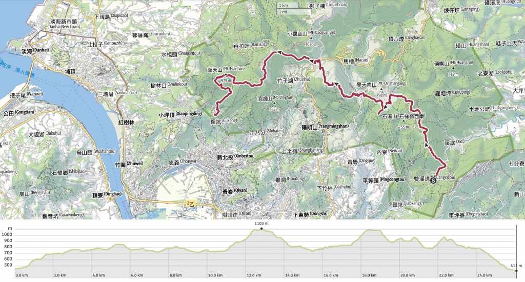
At 26 kilometres, the Yangmingshan East-West Trail is probably one of the longest and toughest walks you can do in Yangmingshan National Park. (Actually, the Chinese name is West-East, but that just sounds too uncomfortable in English, so East-West it is.) Of course, there are harder, steeper, less frequently traversed routes that are challenging in a different way, but in terms of distance and endurance, this one is definitely up there. The fact that it’s so close to the city, and such a long walk makes it an excellent training walk for anyone planning to tackle longer and harder trails in the future. It has also been voted one of the 100 top trails in Taiwan by users of the Hiking Notes app (健走筆記). If you use this app, you can log your process along the route to collect digital gemstones. Why? I’m not entirely sure, but it’s a popular activity among local hikers.
And putting aside all of the above, this walk takes you on a whistle-stop tour of some of Yangmingshan National Park’s most impressive sights. You’ll see atmospheric cedar forests, steaming fumaroles, sleepy water buffalo, and views for days.
DISTANCE: 26km, but don’t worry too much. There are numerous bailout points along the way (Lengshuikeng and Xiaoyoukeng are the two most obvious stopping points).
TIME: 10-12 hours – I walked it in about 11 hours on a hot winter day. Judging from the timings from an earlier part-completed walk, I would have been a bit quicker in cool weather.
TOTAL ASCENT: About 1,600 metres of both elevation gain and loss.
DIFFICULTY (REGULAR TAIWAN HIKERS): 7/10 – With the right footwear and weather, this is challenging but comfortably doable. I was very tired at the end, but I didn’t feel over-expended. Also, since it follows well-defined trails, there’s nothing inherently difficult about the walking. It’s really just that there’s a long distance and a lot of elevation to cover. In hot weather, it would be horrible.
DIFFICULTY (NEW HIKERS): Just no. If you’re new to hiking in Taiwan, just trust me when I say this is not the walk you want to start with—at least not in its entirety. That said, it’s a great walk to start challenging yourself with because there are multiple bail-out points along the way.
SIGNAGE: There’s good signage throughout the park, but it doesn’t specify this trail, it just points to the next landmark, so you’ll need a map or need to know where you’re going.
FOOD AND WATER: I drank 3L, 1L of which was added at visitor centres along the way. In the past, you used to be able to buy snacks from these places. but these days, they have been leased out to a restaurant company, so you can buy food, but you need to eat it there. As a result, you’ll need to take all your food supplies with you. I took three sandwiches, some tomatoes, a banana, and salt candy—the last of these almost certainly helped prevent me from suffering too much in the following days.
SHADE: There are shady sections and entirely exposed sections. The small strip of exposed skin between my sleeve and my glove got burnt in February, so if you’re sensitive to the sun, cover up.
MOBILE NETWORK: One or two spots are weak, but in general, there’s good signal throughout most of Yangmingshan National Park.
ENJOYMENT: I enjoy being able to say that I have completed this. And the scenery along the way is undoubtedly very fine, but once is probably enough. However, if you’re looking for an easy-to-get-to and challenging training walk, this absolutely fits the bill.
SOLO HIKE-ABILITY: This is definitely fine to do solo. The East-West Trail strings together many of Yangmingshan’s most popular routes, so you’re unlikely to be on your own for long. There aren’t any real dangers (save from the water buffalo, but they’re generally very chilled).
OTHER: A hiking stick is a very useful implement to have on this walk. It really helps soften the descents.
TAIWAN 100 MINOR PEAKS: This walk takes in two of Taiwan’s Xiao Bai Yue, No. 1, Mount Datun (大屯山), and No. 2, Mount Qixing (七星山).
ROUTE TYPE: Point to point.
PERMIT: None needed.
Jump to the bottom of this post for a trail map and GPX file.
DIRECTIONS:


06:40 – Every last one of the passengers on the minibus alighted at the Fenguizui bus stop and began the uphill wander to the trailhead. For the first couple of hundred metres, follow the road uphill until you reach the steps heading upwards from the outer edge of a bend.

06:58 – The steps lead up beside a stream. On this trip, as with another walk starting here, I spotted a yellow and black hammerhead worm hunting on the trail. The steps come out by Fengguizui Pavilion, which makes for a good staging post to remove any outer layers and get ready for the


The weather looked set to be glorious which was both great in that it heralded clear skies and amenable weather, but not so great in that I found myself sweating before it even hit 8:30.

A fragment of a jawbone lying in the middle of the path. I’m guessing it’s most likely from one of the park’s water buffalo. For some reason, I had assumed the carcasses of deceased cattle were removed from the park, but I guess not. Or maybe only if they happen to be in frequently visited areas like Qingtiangang Grassland.

07:39 – Ding Shan or Ding Mountain (頂山) is the very first summit of the day. I paused here for a quick drink and the first of my salt candy refreshers before moving on.
07:51 – About an hour into the walk, I found myself passing through this beautiful patch of cedar forest just as the sun reached it. The morning warmth was making steam rise from the dew-damp moss-clad trunks and I felt so lucky to be enjoying the spectacle.

08:15 – The trail climbs gently up the first of two grassland areas and looking back downhill, you get your first good views of Taipei.


08:27 – A little more up and a little more down, and I arrived at the trail’s second summit: Mount Shiti (石梯嶺). I think the Chinese name is more like “ridge” than “peak” but the marker says “Mount Shiti” so that’s what we’ll stick with.

Water buffalo hairs caught on one of the information posts along the path.


Soon after spotting the hairs, I came across this pair of bulls butting heads. They were going round and round in circles, with one or the other gaining dominance every now and then, pushing the other back, or forcing its head to the ground. I’ve walked among the wild buffalo up here many time, but this was the first time I had seen such behaviour and it put me on edge. By and large, these guys are very relaxed, but there are two times when you don’t want to get too close: when a mother is protecting her calf, and when the bulls are getting frisky. This pair were shoving each other over the path, so even if they weren’t bothered about me, there was a real risk they could accidentally trip over me if I got too close. I watched them for about 10-15 minutes and noticed that the head-butting seemed to have a pattern of intense periods followed by short breaks to chew some grass. So, while the pair were having a snack break, I skirted past them.

The trail dips down to another cattle gate right beside the stone Jinbaoli Gate (right, obscured by grass). The Yangmingshan East-West Trail takes a left turn here and heads towards Mount Zhugao.


The scenery of Qingtiangang Grassland is lovely whatever the weather, but under a blue sky, you’ll usually spot a couple of wedding photographers.


Baby water buffalo napping in the morning sun. There was a group of mothers and youngsters along this portion of the walk, all of which were very calm and relaxed.

09:27 – The trail arrives at the second old military bunker (bunker no. 3). To visit Mount Zhugao, you’ll need to turn left, but then later on, the trail tracks back here and takes the path heading right from the bunker and downhill.

09:34 – The summit of Mount Zhugao (竹篙山) is marked with another bunker, and from here, looking past the southern edge of Qixing Mountain, you get your first sighting of the two passive receivers sat atop Mount Miantian (the second to last peak of the day).


I returned back to bunker no. 3 and took the trail heading downhill towards the visitor centre.

At this point, the Yangmingshan East-West Trail is following a portion of the Qingtiangang Circular Trail, which is one of the most popular walks within Yangmingshan National Park. Because of this, you’re likely to be sharing the trail with everyone and his aunt… quite literally.

09:50 – Before reaching Qingtiangang Visitor Centre, turn left following directions to Juansi Waterfall and Lengshuikeng.


As the trail dips into the trees, there are two junctions in quick succession. At the first junction, bear left, then at the second junction, take the right trail signposted as going to Lengshuikeng.

10:08 – The trail runs uphill as far as Jixinlun (雞心崙) before passing through (or around) a shelter and descending once more.

Flanked with more Japanese cedars, this has to be one of the most grand flights of steps in the whole of Yangmingshan National Park. At the bottom of the steps, you can go either way, but I prefer the left-hand route.

10:13 – The two paths encircle Lengshuikeng Ecological Pond before joining up again, but only the left hand trail gets close to the water.

10:16 – Between the pond and Lengshuikeng Visitor Centre, you’ll find Jingshan Suspension Bridge. It’s a favourite spot for wedding photographers, but the last time I was here, a local hiker told me it’s got a reputation for being a breakup spot, so I’m not sure why you’d come here before your wedding.


10:18 – From the suspension bridge, it’s just another 100-200 metres to the visitor centre. This was the point I’d previously reached on my last attempt of the East-West Trail before it started pelting it down.
I took a short break here to use the toilets, eat a banana, and take advantage of the hot water machine to make a coffee. Then, refreshed, I crossed over the road and took the steps leading up towards Mount

At the next junction, the path takes a right turn, where the guy in a yellow shirt is standing. This couple had got off the bus with me at Fengguizui and we stayed either just ahead or behind each other until Mount Qixing East Peak, after which I no longer saw them.


The first part of the climb up is entirely exposed and can get brutally hot if it’s sunny and breezeless. The pavilion here has recently been reopened following a period of renovation.


10:57 – Beyond the pavilion, the path runs up to join the road that passes Menghuan Pond. Instead of checking out the pond, I took a left turn and followed the road until it ran out in front of the National Education Radio Station. Just beyond the station, there’s another fork in the path. Take the righthand trail.

For a short while, there was some respite from the sun as the trail ran through a bamboo-lined tunnel.

One of several chunky skinks spotted on the way up. These guys were enjoying their basking so much that they barely even shifted when I passed. The elegant five-lined skinks, in contrast, were smaller and far more skittish.


11:38 – Five hours after my journey commenced, I reached Mount Qixing East Peak. From here, you get a very clear view of the trail cutting up through the bamboo to the slightly higher summit of the main peak.

11:49 – It took me another ten minutes to make it to Mount Qixing Main Peak. At 1,120 metres above sea level, this is not just the highest point of the East-West Trail, but also the highest point in the whole of Taipei. I paused here to have a quick snack and some of my coffee before setting off again.

There’s only one other path leading away from the summit, so it’s very easy to figure out where to go. (There are a couple of side trails that dive into the bamboo on the way down, but if you weren’t looking for them, you wouldn’t know they’re there.)


The northwestern slopes of Mount Qixing are pocked with sulphur-spewing fumaroles that you will smell before you see. The path takes you close enough that you can see the sharp lines of the sulphur crystals formed around the vents, and looking back up, the midday sun was illuminating the puffs of steam as they twisted on the wind into nothingness.

As you near Xiaoyoukeng Visitor Centre, there is often a large wall of steam drifting upwards from the eponymous Xiaoyoukeng vent.


12:37 – As with the visitor centre at Lengshuikeng, there used to be a store here, but it has since been converted into a restaurant. There’s also a toilet block and another water dispenser, both of which I made use of before continuing on my way. To continue, take the trail heading just to the right of the toilets.


The path cuts through a bamboo corridor. Ignore the first turn-off on the left, but take the second left that you come to (the picture on the right above—signposted as going to Zhuzihu).

12:54 – The trail runs through bamboo for another 100 metres before spitting you out in a carpark. Head straight down the steps beside this old concrete bunker.


Like some kind of carpark waterfall, the steps lead down to another carpark. (There’s a toilet here, it’s the last toilet you’ll encounter until you complete the walk.) From this second carpark, cross over the road and turn right. There’s a pedestrian path running alongside the road that ends at the apex of this bend, where it dives into the treeline.

The path runs along below Bailaka Highway, and the uphill slope is unfortunately somewhat marred by all of the rubbish shitty people have thrown out of their vehicles.


The steps run up to join the road just before arriving at a viewing platform with a view looking back over Mount Qixing, Xiaoyoukeng and Zhuzihu. Technically, the path dips back into the treeline, but… I really did not fancy heading downhill, only to go uphill again, so I walked along the side of the road instead. (When I was new to Taiwan, walking along the road when there was no pavement felt very weird. Now, not at all.)

13:33 – After longer than I remembered, the trail finally rejoined the road again, and a left turn onto the Anbu Trail (鞍部步道) marked the start of another upwards section.

In my memory, this section was nothing too long or challenging, but in the midday heat—and after almost seven hours of walking—it felt decidedly long and difficult.


The first and final thirds of the climb are shaded by bamboo, while the middle third is more exposed and flanked with silvergrass. As I neared the end of this section, I came across a woman harvesting skinny stems of bamboo. She was the first person I’d seen doing so this year. Is February earlier than usual for this?


The trail ends beside a gated government facility and becomes a road.

14:16 – After a couple of hundred metres turn left onto the road and walk the short distance to Mount Datun Main Peak (大屯山主峰).


14:21 – The main peak has a viewing platform from which you can look back towards Mount Qixing or onwards to the southern and western peaks of Mount Datun.
In the righthand photo, you can see exactly where you’re headed. The trail first climbs up the gentle slope on the left side of the image, then summits the sharper peak in the centre before dipping down into the valley on its far side. It then makes a final uphill push to Mount Miantian (the one on the far right with something built on top of it), and Mount Xiangtian (the rounded rise just to the left of Mount Miantian).

14:40 – I had a brief break at the top to finish my tomatoes before starting down the steep stone steps. The trail descends to this junction, and here you need to take a left turn, following the signs directing you to the south and west peaks of Mount Datun.

Just a few paces from the junction, I caused this skittish false viper, aka false Habu (擬龜殼花) to flee into the greenery. It spent a minute poised like this, tasting the air and making sure I wasn’t a threat before slithering off into the undergrowth.

The ascent from the junction to the south peak was not as steep as I remembered it to be. In fact, after eight hours of steps, this gently rising trail was very welcome.

15:03 – The summit clearing of Mount Datun South Peak. I didn’t take a break here, I just barrelled straight over and down the far side.


Ropes assist in the steep and rocky descent. Then, where the trail levels out, take a right turn.

This short flat section was both pretty and very welcome.

15:18 – At the next junction, turn left. The sign indicates its just another 200 metres to the western peak, but do not be fooled. Those 200 metres are brutal.

This photo doesn’t accurately show the steepness of the trail. After so much more walking, it was a struggle.


15:46 – I made it to the summit feeling distinctly wobbly and tired. After a little rest to catch my breath, I wolfed down the last of my sandwiches. The chap sat on the rocks arrived a little after me and asked where I was coming from and heading to. When I told him I was attempting the easy-west trail, he told me it was still quite a way to go and wished me luck.

Setting off again, the conjoined peaks of Mount Miantian and Xiangtian are clearly visible, almost taunting because you know you have to go down only to go up again.


16:02 – At the bottom of a steep, rocky, and rope-assisted descent, the trail takes a sharp right turn past this pavilion. (If you feel like giving up instead of completing the whole trail, the way down is on the left.) Then, after a couple of hundred metres of flat, crunchy gravel, look out for this trail on the right leading up to Mount Miantian.


The sign indicates that it’s only another 600 metres to the summit, but my word, those are some loooooonnng metres.

16:36 – I was pretty much over the concept of mountains when I finally made it to the top of Mount Miantian (面天山), and paused long enough just to snap this photo of one of the two passive receivers before heading onwards to the very last peak of the day.

16:49 – This is the final summit, Mount Xiangtian (向天山). It is also probably the least impressive peak of the whole journey. There are no views to speak of and barely a clearing.


17:00 – The next 400 metres down from Mount Xiantian are characterised by steep steps and a shaded trail. When you hit the circular trail that runs around the outer edge of Xiangtian Pool, take a left turn. Then soon after, take another left turn that’ll lead you away from the pool and down towards the trailhead.

Keep right following the main path here.

17:23 – In a clearing, the defaced remnants of a stone stele sit gathering moss. It was erected during the Japanese colonial era to celebrate the marriage of Japanese Crown Prince Hirohito, but the inscription was later removed after Japan ceded Taiwan.

17:42 – Turn right onto the path at the next junction.

I’d brought my head torch just in case I was out late, but it was still just bright enough not to need it. On top of that, the very final flight of steps had lamps that flickered on once dusk began creeping in amongst the leaves.


17:57 – As I approached Qingshui Temple, the sky over Mount Guanyin was lit up in shades of neon coral.

While inside, the gods had been shut away for the night.

18:00 – I made it to the smaller Qingshui Temple, with its giant banyan tree at bang on 6 o’clock. And within a minute, the minibus was pulling up. I was tired, but satisfied. After three failed attempts, I can finally say I have tackled the toughest trail in Yangmingshan*.
* I am sure there are actually tougher trails.
HOW TO GET THERE
Google Maps address: The trail starts at Fengguizui and ends at Qingshui Temple. There is roadside parking available at both spots, but given that this is a point-to-point walk, it makes more sense to take public transport.
GPS location:
- Fengguzui trailhead – N25 08.225 E121 36.165
- Qingshui Temple trailhead – N25 09.595 E121 30.040
Public transport: Although it’s possible to walk east to west or west to east, the east-to-west version of the walk is logistically better. There is only a handful of services each day that arrive at Fengguizui, with the latest departing there shortly after 6pm. Whereas buses to and from Qingtian Temple run as late as 11pm
- Getting to Fengguizui – Take the first M1 minibus of the day. The bus departs from Jiantan Station at 6:10 on weekdays, possibly with an additional early service a short while later on weekends. Alight at Fengguizui bus stop and walk up to the trailhead. If you get any later services, you will definitely be walking in the dark.
- Getting back from Qingshui Temple – The S6 minibus leaves Qingshui Temple roughly every 30 minutes and will drop you off at either Xinbeitou or Beitou MRT Station.
YANGMINGSHAN EAST-WEST TRAIL MAP
GPX file available here on Outdoor Active. (Account needed, but the free one works just fine.)

Thank you so much for the detailed trail!
I tried doing qixing and dadun today, and sadly the part connecting qixing to xiaoyoukeng is closed due to landfall alret (if I understood correctly, they closed it after the big earthquake in April and didnt finish renewing it since)
Long story short, went up Qixing (had a great view into a cloud so… yeah. The walk was still beautiful!), then walked down to Miaopu, walk next to the road to Juanxi falls (not recommended) and hiked the falls trail back up (recommended. Just the road part was a mess) all the way to Qingtiangang.
Was slightly shorter than I planner but I got lost a ocouple of times and then it started raining so still was a great full day:)
Anyway, the whole comment’s idea is just to update about part of the trail closed (Xiaoyoukeng-Qixing peak)
Thanks again for all the details!
LikeLiked by 1 person
Thank you for the note. I’ll add a note to the top of the post. (Keeping up with all the trail closures and changes is becoming something of a minor headache now that there are so many walks listed here!)
It sounds like you had a great time regardless. Yangmingshan is one of those places that has a different kind of beauty for every weather. Even when it’s rainy, it can still be marvellous.
LikeLike
So, I walked part of this trail on October 26th and the part was still closed, however… I proceed anyway. It is passible, most of the trek is completely fine, there is a section of around 50-100 m. where a huge landslide just erased the path. However, with caution, you can proceed, walk over the landslide (experience on its own) and easily find the continuing path.
LikeLiked by 1 person
Thank you! That’s good to know. Did you notice signage telling you that the path was blocked?
LikeLike
I am planning to walk from Xiaoyoukeng over Qixing Main and East peaks in early January 2025
Is the trail still blocked? Is the damaged part still crossable as described above?
LikeLike
Hi there. I haven’t been there myself since the landslide, so I can’t give you any more information about this section than the above commenter. Google Maps generally has good up-to-date information on trail conditions for popular hikes like these. Just search for the reviews of the trail then pick “newest”. That said, there’s still an alternative route possible. You can walk up Miaopu Trail to the peak and then down to Lengshuikeng.
LikeLike
Thanks for sharing, I just ran this route without Mantian (closed access from Datun West) and it humbled me very much, so ended up with 24km 1600m up under 5h, awesome trail!
LikeLiked by 1 person
Five hours?! Colour me impressed! I’m not sure whether you ran this today or some time ago, but “humbled” most definitely describes how I felt the next day! Wishing your legs a speedy recovery!
LikeLike