This short loop in the flatlands of Chiayi is a gentle way to stretch your legs on a lazy afternoon. I happened to be staying in the city for a night prior to heading up into the hilly areas around Alishan, so I decided to use my spare afternoon exploring a part of Chiayi that I probably wouldn’t visit otherwise.
Distance: 3.6 kilometres.
Time: An hour or so.
Difficulty: 1/10 – This is an exceedingly easy trail regardless of your experience level. It’s more or less flat the whole way around.
Total ascent:
Water: I barely drank anything the whole way, but there are water dispensers at the two temples you’ll pass along the way, so make sure to take a refillable bottle.
Shade: Not very well-shaded. Most locals had either umbrellas or hats.
Mobile network: Clear throughout.
Enjoyment: It’s a pleasant enough little afternoon wander, and there are lots of birds to be spotted along the way, but I wouldn’t go out of your way to visit it.
Bathroom facilities: There are toilets close to both of the temples.
Route type: Loop
Permit: None needed
Jump to the bottom of this post for a trail map and GPX file.

The walk starts from in front of Putou Temple. Quiet Buddhist music was emanating from within the temple, but it was being somewhat drowned out by a busker.

From the temple, I passed some vendors and crossed over the suspension bridge to begin my anti-clockwise loop of the lake.

There are some shaded seating areas here, most of which were occupied by old folk who were busy chatting up a storm.


The scenery is gentle, rural and mostly quite unobtrusive. Yellowing rice fields stretched out to the right side of the trail, while on the left, several decked seating areas offer views of the lake.

One section is shaded with banyan trees whose aerial roots are slowly marching across more and more of the land.

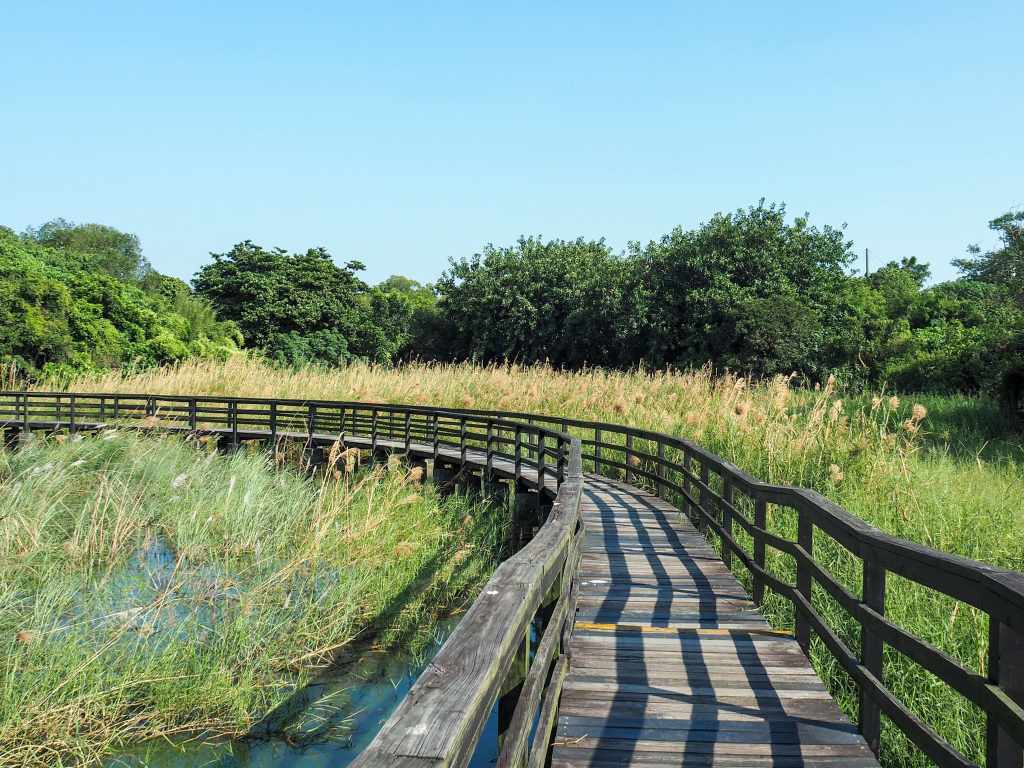
The trail makes its way down to a junction. Ignore the road, and just stick to the lakeside path (not that you can see the lake at this point). (It’s worth noting that the sign here seems to indicate that it is not for pedestrians. However, the very same trail continues just four metres beyond the sign, so I’m not really sure why or what it’s actually referring to. I kept going and there was nothing else to indicate that I shouldn’t be on the trail.) The trail heads along a grassy stretch with prinias flitting in and out of the rushes to my left and bulbuls arguing in the trees to my right. Keep following this path until you arrive at a carpark. Here, the path takes a left turn onto a wooden walkway raised above the water.

This was my favourite section of the walk (despite the distinct decrepitness of the boardwalk). Scaly-breasted munias feasted themselves on the grass seeds, and whooshing, sloshing gurgles from below me indicated the presence of numerous turtles.

Everywhere you look, clutches of pinkish-red eggs indicate the presence of large numbers of apple snails. These invasive aquatic snails were introduced to Taiwan as a potential food source, but the Taiwanese never really took to them.

At the end of the walkway, take the steps leading up to Kaitian Temple (開天府).

Even if you took me here blindfolded, I would know we were well outside of Taipei based on just how sprawling and spread out this temple complex is. The main temple has several satellite temples scattered all around it, including separate and geographically correctly positioned temples for the Generals of the Five Camps, and this tiny shrine dedicated to Fude Cai Shen Ye that is sheltered within a much larger structure.

From Kaitian Temple, I headed back to the road, then took a left turn past a huge abandoned building.

This gorgeos black-winged kite had been sitting on a telegraph pole and making its pigeon neighbours a little nervous before it decided to take off.

Follow the road for about five minutes or until a sign directs you left along a pedestrian walkway that will take you right back to where you started. If you turn left at the far end, you’ll find yourself back by the suspension bridge.

As I was leaving the lakeside area, I stopped to take some photos of the rural scenery: rice field footprints and a scarecrow fashioned from old clothing.
How to get to Little South China Sea
Google Maps address: The walk starts and ends from Putou Temple. There are plenty of parking spaces here for cars and scooters.
GPS location: N23 23.470 E120 23.660
Public transport: The Y6-1 bus service from Houbi Train Station stops at Xiaonanhai Scenic Area several times a day.
My new words learnt on this hike:
- 難民 / nànmín / refugee
- 復古 / fùgǔ / retro
Little South China Sea Trail Map
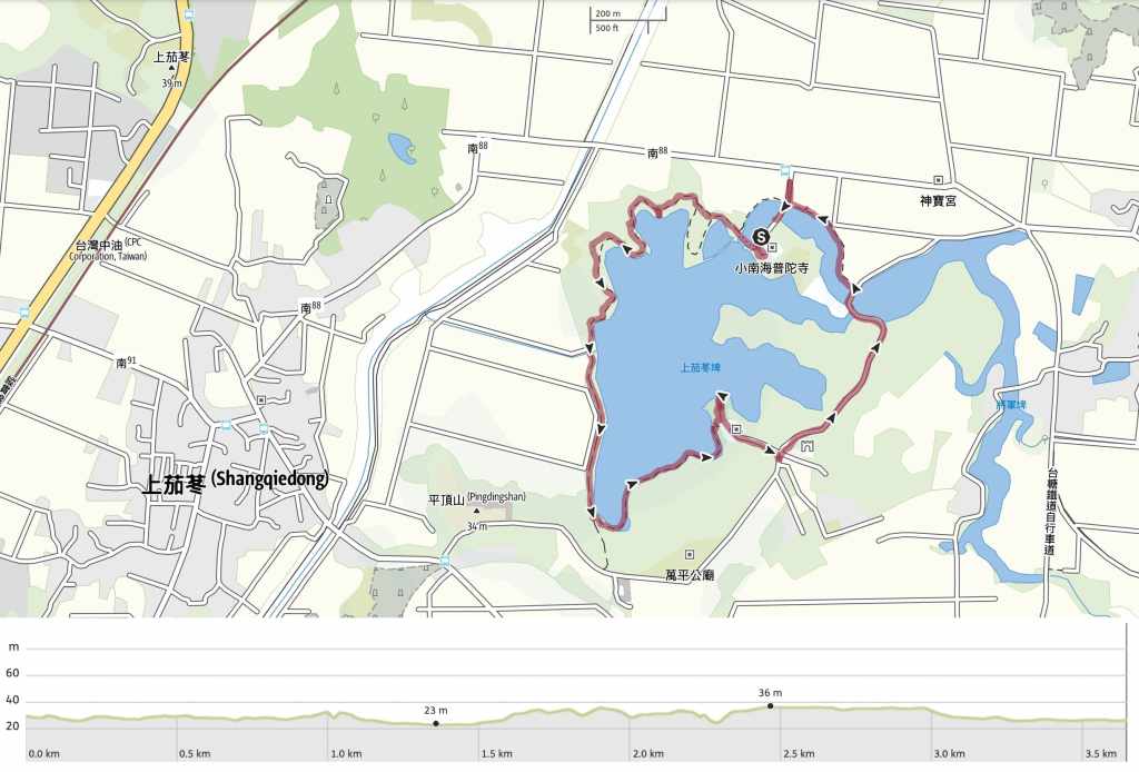
GPX file available here on Outdoor Active. (Account needed, but the free one works just fine.)
