A Beautiful Forested Walk Between Two National Forest Recreation Areas
I love trails that start in one place and take you to another. I know, I know, that’s what literally all trails do, but to be more precise, I like those that are accessed in one town, village, or side of a mountain and end on another (doubly so if they can be accessed with public transport). Dongman Trail ticks both of those boxes, but more than that, it also traverses a stretch of mountainous forest between two of Taiwan’s National Forest Recreation Areas, meaning that you get to enjoy two for the ticket price of one. Well, if I’m being honest, I didn’t spend much time in Dongyanshan National Forest Recreation Area, but my point is that I could have done.
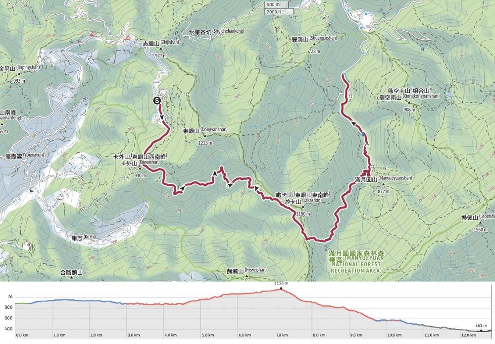
Distance: About 16-17km (including the walks from each trailhead to the entrance of the parks).
Time: It took me five hours to walk from the entrance of Dongyanshan National Forest Recreation Area to Manyueyuan National Forest Recreation Area. However, when you factor in the travel time and waiting for buses, this is a whole-day affair.
Difficulty (regular Taiwan hiker): 3/10 – Some steep portions with knarled and slippery roots, as well as the challenge of actually getting here put this walk on the upper end of easy for anyone already familiar with Taiwan hiking trails.
Difficulty (new Taiwan hiker): 5/10 – If you’re new to hiking in Taiwan, this will be moderately challenging, for the same reasons mentioned above plus the distance, overall elevation gain and how far from civilisation it feels. However, it’s definitely possible and it’s definitely worth the effort.
Total ascent: About 480m. Most of this walk is spent descending (there’s over 1000m of descent).
Food and water: I got through about 2L of water on a hot day (a reasonable amount of which was used for my lunchtime coffee). Food-wise, I took some fruit, chopped veg and bread. I also had salt candy with me but didn’t eat them—something I would live to regret the following day (they seem to significantly reduce muscle soreness).
Shade: Mostly very shaded. I only had to get my umbrella out when I arrived in Manyueyuan National Forest Recreation Area.
Mobile network: A lot of the trail was in a signal dead-zone.
Enjoyment: This is a great walk through beautiful forest and definitely worth enduring the transportation hassle. Point-to-point walks through this type of scenery with public transportation are so rare in Taiwan.
Other: A hiking stick would be a good idea for the descent, especially for anyone whose knees do not like downhills.
Route type: Point-to-point.
Permit: None needed, but you do need to purchase a ticket to enter the park you start in (you don’t need to pay a second time for the one you walk to). Tickets can be purchased from the main gate on the day.
Jump to the bottom of this post for a trail map, GPX file, and transportation information.
In terms of navigation, this trail is so straightforward that I probably don’t need to include more than a dozen photos, but it’s so spectacular that I’d worry I was underselling it if I didn’t include more. Read on to see what I mean.

09:03 – I arrived at the entrance gates of Dongyanshan National Forest Recreation Area shortly after 9am and a good three hours after I left my apartment in Taipei. I queued up with all of the other alighting passengers to buy my ticket (NT$80 for a regular adult ticket on a weekday, NT$100 for weekends), then headed through into the park.


There’s a toilet block on the right just a short way into the park (it isn’t the last one you come across). The road on the left curves up to the visitor centre, but to reach the start of Dongman Trail, you’ll need to head straight. In actual fact, if you’ve not been before, and don’t intend to come back, it might be more enjoyable to take the trails through the trees instead of following the road. When you reach the next junction, stay on the flat and head through the barriers at the entrance to Dongyanshan Forestry Track.

Right at the very start of the track, there’s one of the two views that you’ll enjoy along the entirety of this walk (it’s definitely one for the forest lovers rather than the view seekers). The highest of the peaks on the left is Neiniaozui Shan (內鳥嘴山, 1748m), and the lowest on the right just before the ridge is obscured by trees is Zhutoujiao Shan (竹頭角山, 943m)


09:38 – A track diverts towards a campsite/farm. Ignore it and keep heading straight along the track. There are also two toilet blocks along the way. The second (and last facility before you reach Manyueyuan is hidden just behind the fossil area.

What the park authorities mean when they say “Fossil Area” is a small pavilion sheltering several boulders with evidence of prehistoric tunnelling crab cousins.

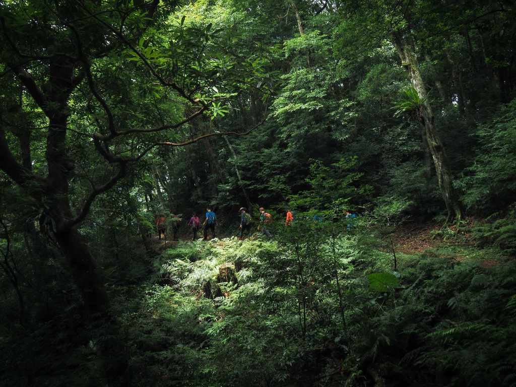
09:48 – Beyond the fossil area, I passed another side trail joining from the Qinzi Trail, then walked past the Afforestation Memorial (just off the path to the right), then found myself at the start of Dongman Trail, right at the same time as the stragglers from a large hiking group (although at that moment, I could only see a handful, so I had no idea that there was actually about forty of them). They all stopped for photos, so I decided to head on in front of them.

There’s some monitoring equipment mounted on a pair of trees beside the trailhead. I saw some on my previous visit to the park too. I wonder how much wildlife they pick up.


10:01 – Steep rock faces rise up on the left of the path, while the gentler slope on the right is densely forested. And unexpectedly, ten minutes after I left the forestry track, there was a toilet block beside the trail. (It seems to have been closed for a while though judging by the paused state of the renovation works.)

I paused for a while to photograph this handsome minibeast, and the hiking group caught up with me. Rather than let this keep happening, I decided to wait and let them get ahead of me so that I could enjoy a solitary walk without the feeling of someone urging me forward.


It was the right choice. The forest deserves to be luxuriated in and enjoyed.

10:08 – The trail winds its way gently around the side of the hill and passes over a small creek or two.

One creek has a little wooden bridge, but the others are diverted though rock-lined channels.

10:16 – A noticeboard marks the boundary with Beichatian Nature Reserve (北插天山自然保護區). At this point, the path hooks a sharp left and heads uphill.


As well as fantastic forests, the paths were absolutely alive with all sorts of fantastic bugs.


The variety of caterpillars was especially interesting. The huge black fluffy ones were the most numerous, but there were many others in all sorts of different shapes and sizes.

From the point at which the trail reaches the boundary of Beichatian Nature Reserve, it climbs and climbs and climbs.


I was still hanging back behind the large group of hikers, which gave me plenty of time to enjoy the little details like these mushrooms that had sprung up after a recent rainy spell.

11:06 – A side trail on the left presents you with the opportunity to do a little extra scrambling up to the summit of Mount Kala (卡拉山). I decided against it since I hadn’t researched the trail conditions in advance. If you’re interested in taking this, make sure you go with a GPX route already prepared since another trail connects at this peak and it would be easy to head the wrong way if you weren’t sure of where you were going.


11:31 – After about 25 minutes, the Mount Kala side trail rejoins the main route in two places.

I also found myself unavoidably caught up with the large hiking group.

11:36 – There were so many of them that they’d strung themselves out over a couple of hundred metres to sit and eat lunch. They’d picked the perfect spot right at the point where the trail starts to descend to take their break. (I think this is also the point at which walkers heading to Mount Beichatian strike away from the Dongman Trail.) I would have been quite happy to take a break, but when one of the other hikers asked me to pose to feature in their video, I made the choice to push on to the next suitable break spot.


From the junction, the path turns sharply to the left and begins a steep and steady descent through more magnificent forest.

There are still slippery tree roots, but the path on this Manyueyuan side seems to have been more constructed than the Dongyanshan side.

12:04 – As I descended further and further, the heat became more and more noticeable. I paused at a stream to cool off a little.


12:06 – Just beyond the stream, there’s a spot that’s marked on the map as a campground. I’m not sure if it really is, or if it’s mostly just a resting point. (25 minute break)

I took advantage of the benches to enjoy my lunch of iced coffee and homemade bread.

I took about 25 minutes to finish my break. During that time, I made friends with a pair of honeybees who seemed to appreciate my sweaty backpack.

Legs rested and belly filled, I got back on the trail.

This caterpillar’s fake snake eyes may fool birds, but they’re not fooling me!

12:43 – The lower down the trail got, the more pervasive the sound of running water became.


A sudden opening on the right gave me a glimpse of Beichatian Shan, or rather, it would have done if not for the clouds. Another ten minutes later, I passed a side trail on the left that was joining from Mount Kala.

13:24 – A little shy of four hours after I entered Dongman Trail, I reached its eastern terminus in iiManyueyuan (although there’s still quite a way to go). To take a quick gander at the waterfalls that Manyueyuan is famous for, take the path leading down to the right without crossing the bridge.


The trail leads past some huge water butts then down some steps (that were just a little bit too deep after the descending I’d already done).

13:28 – At the next junction, head up towards the toilet block. Here you can choose to either go up to a viewing platform above the toilets, or head down to a bridge where you can get closer to the falls. I’d advise you to do both if you have time and energy.
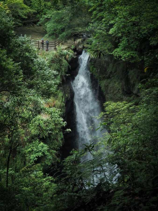
From the viewing platform, the power and scale make the main waterfall dramatically photogenic. (Note the two tiny people in the top left corner.)


Heading back down to the toilets, I turned right to cross over the bridge below the tallest of the waterfalls.

From here, you can just see a glimpse of the roaring water spilling out from behind the rock walls of the gorge.
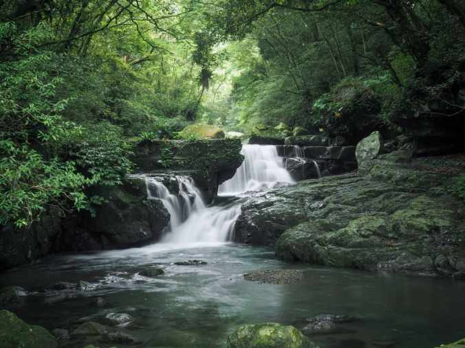
If you head up a bit further though, there’s a very pretty vantage point overlooking a pair of much smaller falls. As with all almost all of the national scenic areas I’ve visited, there’s sadly no dipping a toe in the water allowed. (I would have been in there like a shot if it were permitted.)


Returning back to the toilet block for a third and final time, I followed the trail leading down through the park towards the visitor centre and main entrance.


In front of the visitor centre, there’s a platform overlooking the river, and when I wandered over to have a look, I met a woman who told me she’d been watching the monkeys. We kept looking for a while, eventually spotting one high up in the trees on the far bank. I then took myself off to visit the loos, and when I came out, she presented me with a pineapple cake before saying goodbye and running off.

The visitor centre sells a few drinks and snacks—as with all visitor centres in these places, the choice is limited, but if I were hungry, I would have greatly appreciated it. The rest of the walk down is gentle and follows a surfaced track. I paused to set in the air-conditioned space of the butterfly house and watched a video about all of the various types of wildlife that can be found on small farms.

Once I’d cooled down, I made my way slowly to the ticket gate and then followed the road all the way down to the bus stop. (There’s also a riverside trail you can follow instead if you have time.)

The bus stop is impossible to miss. It’s located in the coach parking lot, so there are plenty of people walking down to this point.
Getting to Dongman Trail
Google Maps address: The walk starts from Dongyanshan National Forest Recreation Area and ends at Manyueyuan National Forest Recreation Area. There is adequate parking at both ends, but since this is a point-to-to walk, you’re better off using public transport or arranging for someone to drop you off and pick you up. If you’re interested in the latter, Parkbus Taiwan organises trips to this very trail every now and then (they will announce all upcoming trips on their website or social media).
GPS location: N24 49.875 E121 24.590
Public transport to Dongyanshan National Forest Recreation Area: It is possible to visit Dongman Trail using public transport with just a little foreplanning (and a couple of transfers and a lot of time).
The key element in the journey is the final bus; the one that goes from Daxi Bus Terminal (the right photo below) to Dongyanshan, so to work out the timing, you’ll need to work backwards from that. On weekday mornings, there are buses at 8am and 11am, while on weekends, there are buses at 8am, 9am and 11am. The 8am bus is the safest choice, which in turn means some bus hopping. (The 9am bus would be doable, but I wouldn’t advise the 11am service.) From the western side of Taipei, the 9005 bus leaves Taipei City Hall Bus Station at 5:39am and 5:46am and passes through Gangqian Road about 5 minutes later. This bus will take you to Taoyuan Bus Terminal Station (the right photo below—it’s worth noting that if you search for this using English, it returns two possible results, the correct one is the one on the south side of the train tracks). From there, you’ll need to hop on the 5090 or 5096 Via Gengliaojiao and ride that to Daxi Bus Terminal. If you’ve made good time, you should arrive with about time to spare before the 506 Taiwan Tourist Shuttle departs.
Alternatively, if you’re based closer to the train line, the journey is a little quicker if you mix rail and bus. You can jump on the local train 1117 (scheduled to leave Taipei Main Station at 6:13am, but it also passes through all of the stations along the route). Alight at Yingge and switch to bus. From Yingge Station, the 5101 will take you to Daxi Bus Terminal in time to catch the 8am 506 Taiwan Tourist Shuttle service.
It all sounds complicated, but honestly, the journey was very smooth, just long. (I also had people at both bus stations checking that I was getting on the right bus.)


Public transport from Manyueyuan National Forest Recreation Area: The 807 bus departs the park at 12:45, 15:45, and 18:10 on weekdays, (15:15 and 18:10 on weekends) and will get you as far as Sanxia. From there, there are several options to get back to Taipei, and you’re probably better off googling whichever is most time-efficient once you’re there. (I took the 702 over to Yingge and then caught a train back from there.
Dongyanshan National Forest Recreation Area Tickets
Tickets can be purchased from the main gate when you arrive. The bus will drop you off just outside the gates. Prices are slightly cheaper on weekdays (NT$80 for a standard ticket as opposed to NT$100), and there are discounts for students and seniors (although I’ve found these tend to be applied differently for foreigners depending on which national park or scenic area you’re visiting).
Nearby trails:
Dongman Trail Map
GPX file available here on Outdoor Active. (Account needed, but the free one works just fine.)
