
An Easy Waterfall Hike Near Hualien City
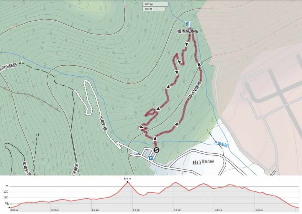
Distance: 1.4km
Time: 1-2 hours – I think the actual walking only took us about thirty minutes, but we spent almost double that resting by the waterfall.
Difficulty (regular Taiwan hiker): 2/10 – A few steps and a little elevation gain. This is an easy and pleasant trail.
Difficulty (new Taiwan hiker): 3/10 – Even people who aren’t regular hikers should find this trail pretty easy going. If you walk an anti-clockwise loop as we did, and you find the climb up to the waterfall tiring enough, then you can just walk back down the same way.
Total ascent: A little under 150 metres.
Water: A single 0.5L water bottle should suffice. It would be a nice place to come for a picnic if you visit around lunch time.
Shade: Mostly well-shaded. I was ok with just sun cream even on a sunny day.
Mobile network: Not strong, but just about ok throughout.
Enjoyment: This is a very pleasant easy walk and a great place to spend a hot summer afternoon.
Bathroom facilities: There’s a toilet block at the trailhead.
Other: Two trails start from this trailhead. This is the shorter of the two.
Route type: Loop
Permit: None needed
Jump to the bottom of this post for a trail map and GPX file.


We parked our crappy rented scooter under the sprawling branches of a beautiful twinned pair of camphor trees and made our way to the start of the walk. There are two trails which start from this precise spot. The Sakul Waterfall Trail is the shorter of the two and stars by crossing a wooden bridge.

On the far side of the bridge, the path splits in two. Both arms of the trail are pretty short and easy, and both lead you to the waterfall. We took the right hand path and started walking in an anti-clockwise loop.


Heading in this direction, the climb is gradual. There are a few flights of steps, but for the most part, you’re just climbing up a gentle slope.

Along the trail, there are more tall camphor trees and so many different types of fern. One in particular caught my attention. Its shiny, waxy-feeling leaves had smoother edges than the more common frilly ferns, but its most noticeable feature were the pronounced grooves of each vein spanning out from the midrib. It was very satisfying to run your hand over them, and I’m sure they could be almost musical if you did the same to a dried leaf. I’d not come across this type of fern before, so I didn’t know what it was at the time, but iNaturalist suggests it was probably Bolbitia heteroclita-a species that seems to be limited (in Taiwan) to the east coast from Hualien down to the tip of Pingtung.
It took us less than 20 minutes to make it from the trailhead to the waterfall. There was another group say there to enjoy the refreshing air when we arrived, but they soon packed up and left us to enjoy it in peace. Despite the city being unbearably hot, the temperature in this little clearing was absolutely perfect.


The water felt so extremely clean, and something about either the water or the mineral composition of the stream-bed’s rocks meant that walking in the water was unusually non-slippery. I swear I could sense that the water felt somehow different on my skin. Is that even a thing? I know you can differentiate the slightly slimy slickness of saltwater from regular stream water, but I’m telling you, this felt as clear as it looked.

We spent almost 45 minutes here, and apart from one woman who walked straight past, we had the pool to ourselves the whole time. And naturally, Teresa being Teresa meant that she wanted to be fully immersed in the water.
After getting dressed again so as to prevent Teresa from startling any passing uncles, we continued our clockwise loop.


The very last stretch of trail follows this quite new-looking wooden walkway.

The path climbs quite steeply away from the waterfall for 5-10 minutes. But the trail is well-built and the fern-covered trees offer a pleasant distraction.

At this point, the official trail goes up and round, but a shorter path has been cut straight across the side of the hill. We took the original route so as to not contribute to the wear and tear on the non-sanctioned path.

Just as the final descent is about to begin, there is a small viewing platform which affords you a view over downtown Hualien and out towards the sea.

And then about 25 minutes after leaving the waterfall, we found ourselves back at the trailhead.
How to get to Sakul Waterfall Trail
Google Maps address: The trail starts from a large carpark in the northwestern edge of Hualien City. There is plenty of space for cars and scooters here.
GPS location: N24 01.125 E121 34.625
Public transport: There’s no public transport from the city centre to the trailhead. (Well, there is a bus that’ll get you closer, but not that close and the bus is infrequent.) You’re better off finding a taxi driver who’ll be willing to give you a phone number so you can ask them to take you there then come back when you’re done.
Further reading: The waterfall is briefly touched upon in this Taipei Times article.
Nearby trails:
- Liyu Lake
- Qixingtan Beach and 48 Highland
- Zuocang Trail
My new words learnt on this hike:
Sakul Waterfall Trail Map
GPX file available here on Outdoor Active. (Account needed, but the free one works just fine.)
