
Daylilies on Sixty Stone Mountain and an Easy Xiao Bai Yue
Mount Wanren is an easy Xiao Bai Yue in the south of Hualien County. Although the climb to the summit is short, if you time your trip right, you can combine it with a visit to the spectacular daylily fields on the nearby slopes of Sixty Stone Mountain.
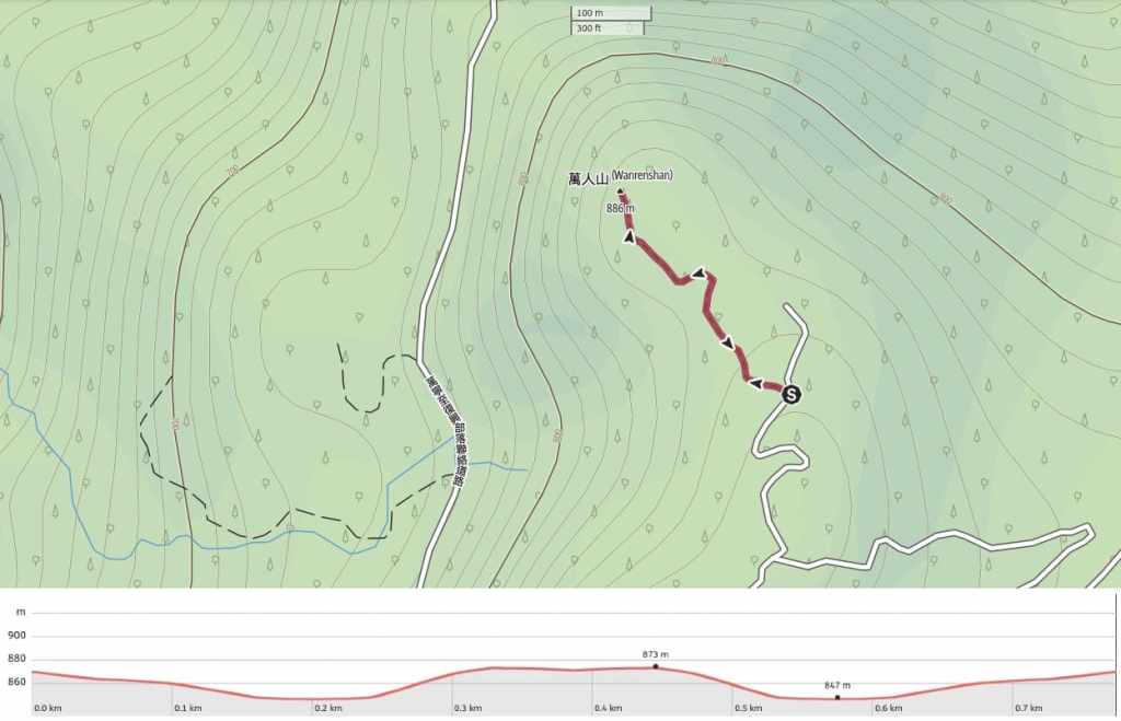
DISTANCE: About 0.8km if you only do the trail section, or 3km if you walk the track too.
TIME: 40-90 minutes (depending on where you start the hike).
TOTAL ASCENT: Around 50 metres if you only walk the trail as we did, maybe double that if you walk the track too.
DIFFICULTY (REGULAR TAIWAN HIKERS): 2-3/10 – Scruffy and indistinct trail, but if you’re into collecting Xiao Bai Yue, this should be one of the easy ones.
DIFFICULTY (NEW HIKERS): 3-4/10 – Although very short, this would have stressed me out when I was new to Taiwan on account of the fact that the trail doesn’t really look much like a trail. That said, it’s not really physically demanding except for the last couple of minutes.
SIGNAGE: None. There are barely even trail tags.
FOOD AND WATER: We took about 0.5L each but didn’t end up drinking any.
SHADE: Dappled shade for most of the route. I was OK using my hat for this one.
MOBILE NETWORK: Clear signal throughout.
ENJOYMENT: If I’m being honest, the views you can get over the flower fields are probably enough to satisfy the average person. I would not put this peak on your “must visit” list unless you intend to climb every 100 Minor Peak.
SOLO HIKE-ABILITY: I wouldn’t be worried about hiking this alone.
WHEN TO SEE DAYLILIES: The best time to visit Sixty Stone Mountain and the daylily fields is July to September. We visited at the end of September and after the east coast had been battered by a typhoon, and there were still flowers to be seen.
TAIWAN 100 MINOR PEAKS: Number 92, Mount Wanren.
ROUTE TYPE: There and back.
PERMIT: None needed.
Jump to the bottom of this post for a trail map and GPX file.
DIRECTIONS:
The online route descriptions that we found all suggested that people parked up by a farm and walked the remainder of the track up to the start of the trailhead, but the farmer told us it was fine to go up the track on our scooter and park right by the trailhead. Doing this probably halved the distance we covered, which, despite the lovely views along the track, was probably no bad thing judging on how nonplussed Teresa was by the climb up to the summit of Mount Wanren. I’m not sure if it was because of the typhoon that passed through about a month earlier, or because that’s just how things are here, but the trail was a little rough around the edges.

12:22 – The trail starts from a barely-marked curve in the track. Look out for a hiking tag or two hung from the tree and a very faint trail leading through the grasses.


12:25 – The trail is essentially just a strip of grass that hasn’t been planted with any daylilies, and it loosely hops from tree to tree. Once you hit the tree line, the path seems to disappear. It looks like the original trail went around the leftmost edge of this fence, but that part is now impassable. After looking around for a bit, we found a faint trail leading over a fallen part of the fence and into the trees beyond.


The first part of the trail was scruffy but easily walkable. We had to duck over and under a few downed trees, and there were no hiking tags, but it was still easy to see where to go.

A tree doughnut. (Actually, I’m not really sure what kind of seed pod this is, but I’d advise against eating it whatever it is.)

After dipping down and rounding a bend, the trail becomes a little more grabby. Tall grasses encroach from both sides and on top, and after an earlier brief rain shower, it was also a little damp.

A beautiful furled curl of fern ready to unleash its prettiness on the world.

The final climb to the peak is a steep scramble through more grasses. Teresa was unimpressed.


12:43 – My phone registered collecting the Hiking Biji summit “gem” a couple of minutes before we arrived at the actual summit.

The top of the hill is a small clearing with a marker stone and views to the north and west over the east rift valley.

It feels a little unfair to get such pretty views for less than half an hour of walking.


13:02 – The way down was uneventful aside from running into another couple with a machete who seemed to be having difficulty finding the trail, and we were back at the scooter in under 15 minutes.
Since we’d arrived at the tail end of the daylily season, we stopped on our way back down to enjoy the sea of bright orange flowers carpeting the hills. There were a handful of workers out in the fields picking the flowers and lots of small farmsteads selling bags of dried flowers as well as dubious-sounding daylily snacks like ice lollies or sausages (although maybe they’re as mildly inoffensive as the daylily soup I’ve had in the past).

How to get Sixty Stone Mountain and Mount Wanren
Google Maps address: The walk starts from a nondescript place away from most of the farms on Sixty Stone Mountain. If you have a car, you might find it a little hard to park, but on a scooter, you can park on the roadside right at the point where the path starts.
GPS location: N23 13.825 E121 19.125
Public transport: There’s no public transport that will get you to this trailhead. Your best option is probably to rent a scooter (it’s more pleasant to navigate these narrow and winding roads on a scooter than in a car anyway). If you’re only interested in seeing the lilies, there are usually some seasonal transport options available via services like KKday or Klook.
Further reading: Foreigners in Taiwan have written about Sixty Stone Mountain here.
MOUNT WANREN TRAIL MAP
GPX file available here on Outdoor Active. (Account needed, but the free one works just fine.)
