
Summers in Taipei are time for sunrise, night hikes, and trails which stick close to the water. This path could reasonably cover all three bases. It offers an expansive city view which faces east and starts beside a swimming pool. For this very reason, it’s somewhere we tend to come back to at least once or twice a year. This time, we decided to visit after dark.
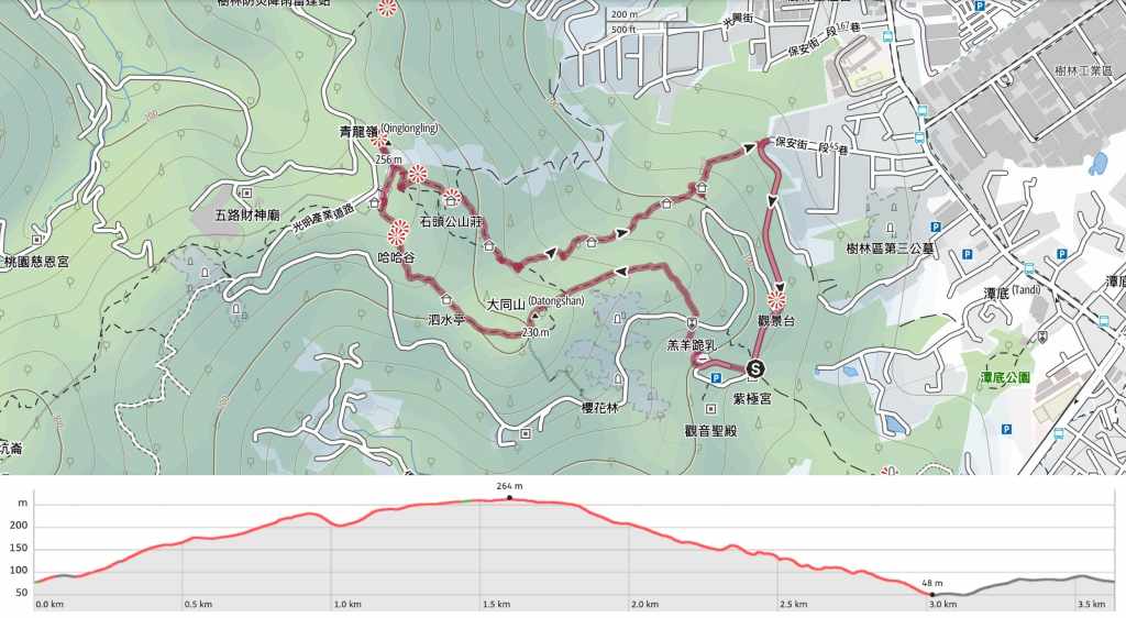
Distance: About 3.6km.
Time: It took us about 2½ hours, but you could do it quicker.
Difficulty (regular Taiwan hiker): 2/10 – There are some steps to contend with and it might be a little tough to navigate if you haven’t previously walked the trail in daylight conditions.
Difficulty (new Taiwan hiker): 4-5/10 – As a daylight walk, this is a breeze, but if you’re new to Taiwan, I would not recommend picking this as your first night hike. Even as someone who is familiar with hiking in Taiwan, I might be a little unsure that I was heading the right way had I not got a map (and prior knowledge of the trail).
Total ascent: About 270m.
Water: A single bottle each was enough for a night walk.
Shade: In the daytime, this route offers dappled shade.
Mobile network: Pretty clear cellphone coverage throughout.
Enjoyment: We’ve seen wildlife both times that we have done this as a night hike (snakes, frogs, an owl and a civet), so it seems like a good choice if that’s what you’re seeking. It also has a pretty impressive city view.
Other: You’ll need to bring a torch (plus spare batteries) since there’s no lighting on the ascent.
Route type: Loop
Permit: None needed
Jump to the bottom of this post for a trail map and GPX file.


We parked up at the foot of the stairs leading up to Nanliao Fude Temple (南寮福德宮), just as the karaoke bar was being set up for the evening. There are always a lot of dogs here, and as usual, one barked, but it slunk away when Teresa tried to speak to it. When you climb the stairs, you’ll find yourself looking at some more stairs. Head around to the left of them and towards the sound of more karaoke.


The walkway leads towards what is probably my favourite swimming pool of all time: The Dinosaur Pool (at least, that’s my name for it, it’s actually called “大同山室內游泳池”). Walk straight up to the pool, then turn right and climb the steps leading up the side of the building. (If you need the loo, this is the last place before you reach the top.)


You have to turn around and climb two flights of steps before reaching the top rear edge of the temple building. Here, turn left and walk to the end of this row of benches, then once you reach the end of the row, follow the steps up to the road. The actual hiking trail starts here, just over the road from a large Tudi Gong statue.

Even though it was after sunset, the prospect of climbing up these steps in the summer heat was not particularly appealing.


There are a couple of junctions and side trails to be aware of. The first joins from the right and connects up with the route we’d later take to head down, and the next one on the left heads towards a cherry blossom trail.


The big climb finishes at a small land god temple with a view on top of Mount Datong. Tudi Gong and his wife, Tudi Po, sit on the altar gazing out towards the expanse of Taipei basin.

If I’m being honest, the view here is pretty much the same as the view at the top—the only difference is that the view at the top is a touch more open. But if you’ve made it this far, you may as well keep going. The remainder of the climb isn’t as steep as the first part.

Heading onwards from Mount Datong, we passed another turnoff on the left for the cherry blossom trail, and walked past a pavilion with adjoining exercise area.


There is a little bit of downhill and a little more uphill. Part way up the uphill, there is a side-trail to a viewing platform, but there’s little to see from up there at night.


The trail emerges into a clearing behind Qingde Temple (青德宮). If I hadn’t been here several times before, I would very definitely not be getting safe vibes from it. In the daytime, though, it’s a busy hiker hub, and on weekends, it’s pretty much a supermarket. We headed right here between two buildings, then just before the path starts to descend again, we took the steps leading up to the left around a metal fence. If you follow the fence around, you’ll find more steps to climb, and within a minute you’ll reach Qinglong Ridge viewing area.

But first, we had to stop to bother the sleepy dogs.
The viewing area is just an open spot on top of the hill, but the views it commands over the whole of Taipei are pretty impressive. We were even able to identify the bright lights of Bishanyan Temple (and more-or-less the location of our apartment). I usually take pretty straight photos for this site, but on this occasion, I felt like playing around a bit, so I got Teresa to stand still for two-thirds of a long exposure shot. I think she did an admirable job of mimicking a statue.

After satisfying my photography itch, we returned to the junction with the picnic table and the dogs and made our way past a toilet block to start the descent.


There are quite a lot of junctions in this section, and they all look the same in the dark, so it’s worth going with a map in order to avoid going round in circles. At the first junction, we took the right trail then a left not long after.

The two paths from that first junction join up at a spacious rest area after a couple of hundred metres.

The rest area is furnished with a pair of conjoined temple-this red one is the smaller of the two. I find its grinning tiger god extremely cute and not in the slightest bit fearsome.


Continuing the downwards journey, we went left at the next junction and fell in step with a small stream. The forest here was obviously more lively than the path we’d climbed up on-we saw frogs and bugs aplenty. At the next junction, we took a right and walked through some fenced-in areas of private land.

A yellow underwing moth resting on part of the fence.

Turn left down here and follow the steps. (The dirt path on the right connects up with the steps this walk follows close to the start.)


Soon, we found ourselves passing the mountainside karaoke restaurants that seem to be really popular around here. At the first, the path cuts around the left side of the building, and at the second, you have to cross straight in front of the restaurant to reach the steps. The staff looks perplexed to see us passing through with our head torches.

Make sure you take a moment to enjoy the view from the top of the steps, since it’s the last view of the walk.

When I was done taking photos, I found Teresa stopped and watching this collared scops owl.

Then almost as soon as it flew off, I spotted a pair of eyes staring at me from the undergrowth. They belonged to a sneaky-looking masked palm civet. Taipei’s nighttime wildlife is far more varied than what can be seen in the daytime.


At the bottom of the steps, we turned right and walked up the road past a toilet block and followed the road all the way back up to where we’d started.
How to get to Mount Datong and Qinglong Ridge Trail
Google Maps address: The walk starts close to Nanliao Fude Temple. There are roadside parking places for scooters and some cars all along the road leading up to here.
GPS location:
- Scooter parking – N24 59.725 E121 24.710
- Trailhead behind temple – N24 59.780 E121 24.640
Public transport: One way to get here would be to take a local train to Shulin Station and walk from the Shulin to the trail entrance – trains could be caught at Banciao or Taipei Main Station. Otherwise the 985 bus (San Chung Bus Company) runs from Haishan MRT station to the mouth of the road leading to Nanliao Fude Temple.
Further reading: The temple at the start of the trail is home to an old pool full of crumbling dinosaurs.
Nearby trails:
- Fuyuan Ancient Banyan Trail
- Mount Datong Trail (Daytime walk in the area.)
- Taipei Skyline Trail – Section 8
- Yingge Rock Trail
Mount Datong and Qinglong Ridge Trail Map
GPX file available here on Outdoor Active. (Account needed, but the free one works just fine.)

Pingback: Bishanyan Temple: A panoramic view of Taipei City in Neihu, Taipei.