
An Easy Summer Walk in Pinglin
This short and easy wander starts and ends at Pinglin Old Street. Although I walked it, the trail is actually a bikeway that sticks close to Beishi River, so it’s flattish with just some gentle hills. It’s the kind of walk that’s ideal for days when you want to get out and go exploring but don’t fancy going off-grid.
Distance: About 7km, or a little more if you walk the whole of Cukengkou Trail.
Time: 1-2 hours depending on whether or not you want to enjoy the water.
Difficulty: 1-2/10 – This is a very easy trail regardless of experience level. The only steps are on the optional climb up to the Guanyin Pavilion, and the rest of the trail just follows a bike path.
Total ascent: Under 50 metres.
Water: I drank about 0.8L on a very hot summer day.
Shade: Not a lot of shade. I needed to keep my umbrella up most of the time.
Mobile network: Clear cell coverage throughout.
Enjoyment: The views along the river and the stream paddling area make this a wonderfully cooling summer wander.
Other: Remember to pack a small towel if you plan to have a paddle. Some people I met were fully prepared with picnics and seating so they could spend a whole afternoon in the cool water.
Route type: There-and-back.
Permit: None needed.
Jump to the bottom of this post for a trail map and GPX file.

If you ride the bus all the way to the terminal station, you’ll get dropped off in the little bus depot close to Pinglin’s main drag. (Just a few metres down the road on the left.)


If you need to get provisions, you’ll want to head up the Main Street first, but if you’re ready to go, you can just wander down Shuiliujiao until you reach the next junction.

Wherever you turn in this town, you’ll see tea-themed motifs. From the cheerful tea leaves that adorn the pavement to the teapots lining the bridges over the river and these overly ornate street lights.


Here, take a left and turn up Pinglin Street following signs to the Pinglin Old Street and tea museum.

I’d not visited Pinglin Old Street before, and found it to be quite lovely. It’s not as touristified as some of Taiwan’s old streets, and it’s clear that a lot of the own-occupiers are old tea farmers.

One shop selling all kinds of farming supplies caught my attention.


I also enjoyed the twin temples placed at either end of the core section of old street. This old street and the temple on it were resting points along the old Tamsui-Kavalan Trails, a network of footpaths connecting Taipei with Yilan. Tea traders would travel out from here to sell their wares in the two larger settlements.

The larger of the two, Baoping Temple, sits at the street’s northern edge and has a really pleasing double-layer structure. The temple’s history is relatively long. According to a sign placed nearby, it was established in 1862 (the current version is a later rebuild) and is the oldest temple in this district.

One of the details that stood out to me about this temple are the wooden altar censers for burning incense. (They’re more commonly made of either stone or metal.)


If you keep walking up to the top end of the street, you’ll soon join Pinglin Road. Turn left and follow the road up to the fire station. If you look to the right here, you’ll see steps that will take you up to Pinglin’s Guanyin Viewing Platform.


If you turn to look back when you’re part-way up the steps, you can see the town spread out behind you.

A small temple sits almost at the top of the hill, and just beyond that, stands a bronze statue of Guanyin with a Mona Lisa-esque smile.


Two pairs of stone lions stand guard to the front and the rear. Note the cub and *ahem* member indicated which are male and female.


If you walk behind the smiling statue, you’ll see steps leading down the far side of the hill. To the right, cars roar along National Freeway No. 5 before diving into the northwestern edge of Hsuehshan Tunnel (after almost 13km, they will re-emerge in Yilan). When it opened in 2006, (having claimed the lives of 25 workers during its construction phase), the tunnel dramatically cut travel time between Taipei and Yilan.
It seems a little strange to find a tunnel on the northeastern coast bearing the name of Taiwan’s second highest mountain, and indeed, it was not originally going to be called Hsueshan Tunnel. At first, planners had intended to call it the Pinglin Tunnel, but residents in Toucheng (the part of Yilan it arrives in) objected. Instead of going with Pingcheng or Toulin or another one of these portmanteau names that are common for roads and tunnels, it was decided that since it cuts through one of the outermost ridgeways of the Xueshan Range, it would be named after that instead. (It seems the official English spelling uses the Wade-Giles spelling rather than the Hanyu Pinyin that is more commonly seen when naming the mountain itself.)

The steps heading down on the far side are shaded and algae has grown on them, making them slippery in places.


As the trail curves around, it passes a sloped planted with tea bushes, and you can look back to see Guanyin standing tall on her hilltop platform.

If you follow the trail all the way down, you will find yourself rejoining Pinglin Road. Turn right here and follow the road towards the noise of the freeway.


Except for where it passes under a bridge, there are no pavements, so make sure you pay attention to the traffic. Keep following the road you’re on until it crosses over a stream right beneath the freeway.


At this point, turning left will take you to Xiakengzikou Stream Recreation Area, and going right will take you to Cukengkou Trail.
I planned to save the streamside trail till last, so I headed right along the path/bike trail. The path follows a tributary stream as it makes the final portion of its journey into the Beishi River, almost immediately opposite the mouth of Hsuehshan Tunnel.

After that, it takes a left turn and starts to turns away from the water for a short stretch.

Then after the bridge, the path hooks around the edge of a hill as it makes its way back to the river.

Across the water, families were barbecuing and playing at this campground. The owners have (quite possibly illegally) roped off a chunk of the river for their patrons.


Along the next stretch, the path runs right alongside the water. I saw and heard countless kingfishers farming from branch to rock, and at one point, I was lucky enough to see one dive in to snatch a fish.

For the most part, the river is wide, slow and exceedingly enticing on a hot day.

The path runs down to meet Linyuan Campsite. The campsite looked a bit unloved, and Google reviews suggest that it has a few problems. A sign had been placed in front of the path here saying that tiger head hornets had been seen in the area and not to go any further. However, the sign looked weather beaten enough for it to be old, so I decided to brave it. The path runs along the bottom edge of the campsite and it’s clear that the camp authorities want to discourage people from walking through. It’s overgrown and not signposted. I got about 100m along, and then a hornet buzzed into the middle of my path and adopted a defensive stance. It may well have been willing to let me pass and I may well have been able to find an alternative route, but I was hot, tired, and not willing to fuck around with a territorial hornet. So I retreated, heading back the same way I’d come.

A fisherman waiting for a tug on his line.


After walking all the way back to Xiakengzikou Stream (near the start of the trail), I took my shoes off to paddle in the shaded waters under a bridge. The stream was full with all sorts of little fish. Interestingly, the ones with vertical stripes are far bolder than those with a single horizontal stripe, occasionally swimming up to nip at my toes.

Beyond the bridge, a shady path follows the water upstream.

As you round a bend, rows of tea line the slope on the opposite bank.

And a little further up, there are a few deeper pools in the shade of the towering freeway.

I followed the path to its furthest limit, which was this spot where a small chunk of farmland sits neatly tucked into a fold in the landscape. The farmer rocked up on his scooter just as I was about to turn around—his straw-hatted, be-slippered straight-forwardness and the frenetic thrum of the motorway made for a striking contrast.

From there, I turned around and followed the road all the way back to Pinglin and a vegetarian feast from Datou Vegetarian (deep-fried battered tea leaves is a menu highlight here).
How to get to Pinglin
Google Maps address: I started my walk from Pinglin bus station, but the riverside trail starts from right underneath junction 15 of Freeway No. 5. There are several car parking spaces here, but not many.
GPS location: N24 56.605 E121 42.690
Public transport: The easiest way (and only direct way) is probably to catch the 923 bus from Xindian to Pinglin Station. Services run roughly every 30 minutes.
Further reading: There doesn’t seem to be much (any?) English info out there about this little spot, but you can easily find Chinese info.
Nearby trails:
- Dashehu Trail
- Jingualiao Fish and Fern Trail
- Mount Kaiyanlun Tea Terrace Trail
- Tamsui-Kavalan Trails: Pinglin to Qingyun Bridge
- Tamsui-Kavalan Trails: Qingyun Bridge to Jiaoxi
- Tamsui-Kavalan Trails: Wutuku to Pinglin
Xiakengzikou Stream and Cukengkou Trail Map
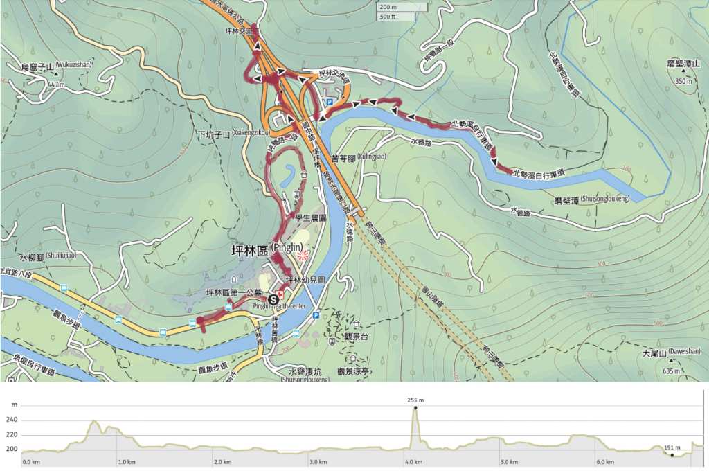
GPX file available here on Outdoor Active. (Account needed, but the free one works just fine.)
