
Take in the Tea Terraces of Pinglin District
Sometimes having restrictions forces you to look for options you might not have previously considered. That’s how we ended up choosing this trail in Pinglin for our Dragon Boat Festival wander. The goals were to find something short and close enough to complete in an afternoon – preferably after the 3pm showers had subsided – and somewhere that wouldn’t have been washed out by the heavy rains we’d had for the previous few weeks. Well it turns out that we picked a great one! The walk up to Kaiyanlun Shan is short, sweet, and has the most spectacular views on the way down.
In fact, it was such a treat that I would highly recommend it to anyone who is looking for something a little different. You could even turn it into a neat little day trip from Taipei. It’s accessible on public transport (see below for more details), and while it might not be as easy to get to as some places closer to the city, it is possible, and if you catch one of the earlier services, then you can head back to enjoy afternoon tea in Pinglin.
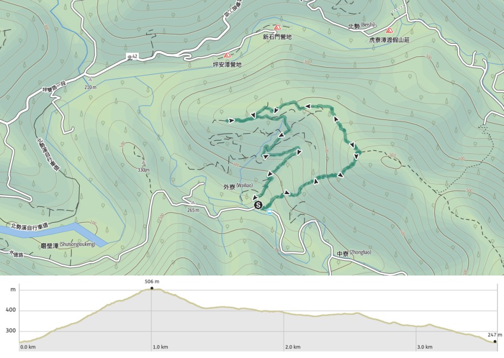
Distance: About 3.6km, give or take a little.
Time: 1½-2 hours – It took us around an hour and forty minutes including some time spent sheltering from the rain.
Difficulty (regular Taiwan hiker): 2/10 – Steep on the way up, and slippery on the way down, but short and easy to navigate.
Difficulty (new Taiwan hiker): 4/10 – A little out of the way to get to, some steep and muddy trail to climb, and equally steep on the way down.
Total ascent: Around 260 metres, all done in one solid push.
Water: I took 0.5L, and drank about half on a rainy day.
Shade: The first half is quite shady, the second half, not so much.
Mobile network: I had no signal at the start, but it was clear almost as soon as we climbed out of the valley.
Enjoyment: This is a perfect short and sweet adventure for when you only have half a day to spend, there’s enough of a climb to get your heart beating faster, and the views on the way down are a great reward for your efforts.
Other: Combine with a wander around Pinglin for a full day out.
Route type: Loop
Permit: None needed
Jump to the bottom of this post for a trail map and GPX file.

We started our walk from the tiny farming hamlet of Houdegangkeng. A couple of maps mark the start of the trail, we headed to the one a little further up from the bus stop and started climbing.

Looking back at where we had started from the very start of the climb, just before we ducked into the trees. The air around us was bird central – a posse of blue magpies bickered over the best spot, grey treepies looking like their drabber younger cousins. Elsewhere barbets and black bulbuls competed to provide the aural soundtrack to the afternoon, and a lone plumbeous water redstart perched on top of a pole, as far away from water as I’d ever seen one be.

The trail very rudely does not give you any time to warm up. Instead it goes up steeply right out of the gate.

There’s one junction, where a farming trail cuts straight across the hiking path, we paused here to apply bug repellant before continuing onwards and upwards.

Our companion, K, got to experience her first ever kamikaze cicada screech attack (hilariously, this occurred just seconds after I’d told her that if she heard a sudden shriek it would just be a cicada launching itself at us).

Just before the summit, there is a trail leading off to the left, this is where we would head down.

It took us about 35 minutes to reach the top, and as we did so, we heard the rumbles of distant thunder and saw flashes of sheet lightning. Interestingly, a sign on the summit warns hikers not to hang around if there is thunder and lightning (I haven’t seen many such signs, so I guess this place must be prone to it?), and so we took just a brief moment to enjoy the view before beating a hasty retreat.

This was taken just a little way down from the summit looking in the direction that we were headed in. After taking this, I had to stow my camera away in my bag because the heavens opened and despite the tree cover, we found ourselves in quite the downpour. (We had brought umbrellas, but what with the nearish lightening, it seemed safer to just get a bit damp, luckily it was a warm day, and the rain just served to wash away the sweat and grime that we had accumulated on the way up.)

By the time we found ourselves emerging from the tree line, the rain had eased from a torrential downpour to just a steady drizzle, and more importantly, the thunder and lightning had moved beyond our hearing.

The view as we headed down the (slippery) path was stunning, a real feast for the eyes. Actually, you can go either way down from here, but we chose to go straight/right when we joined the farming track because the views looked better that way.

We were not disappointed! Wispy clouds flowed over the distant hills, and we watched the rain roll in over the next valley.

From our vantage point, we could also see the tea farmers and their dog go about their business. I always feel torn when looking at this type of landscape, there is something about the artificial geometry of the tea plantations combined with the organic way that they flow over the curves that is just immensely pleasing to my eye. But in another light, it is probably not good for the land to be doing this on a large scale.

We were briefly delayed by another downpour, taking shelter under a clump of bamboo as we waited for it to pass.

We followed the signs directing us back to Pinglin, except for at this next junction we took a detour to the right to look at the view.

Even the farming roads look unfairly beautiful–this is definitely another one of those times when Taiwan sneakily ambushed me with way more beauty than I was expecting to encounter.

I mean look at this! This is straight out of some film set in the bucolic olden times. How is it possible to just accidentally stumble on such prettiness?!

We joined the trail we had been on previously and continued heading back down towards Pinglin, turning right here to head down to where we’d seen the farmers earlier on.

By this time, there were even implausible patches of blue sky peeking through. (Keep heading straight on at the sharp bend in the middle of the photo.)

Left here and follow the very steep road down towards the start.

The lane leads down to the small collection of farms (and a karaoke place?) that make up Houdegangkeng, we turned left and passed one of the buildings with a handsome guard dog with a name better suited to a tubby chihuahua: Pudding (well, 布丁 to be precise).

And then all too soon we were back at the car. Throwing all dignity to the wind (who am I kidding, we had none to lose), we changed our clothes right there in the street. I am too old to care anymore, it just felt very good to be dry again as we set off in search of dinner.
How to get to Kaiyanlun Shan
Google maps address: The trail starts from the tiny community of Houdegangkeng in New Taipei’s Pinglin District.
GPS location:
- Houdegangkeng trailhead – N24 56.445 E121 44.015
- Tea plantation trailhead – N24 56.740 E121 44.205
Public transport: Getting here on public transport is only possible on Saturday or Sunday (and I think national holidays), and will require at least two buses.
- Getting to Pinglin – Take the GR12 bus from Xindian Station to Pinglin Station. There are public toilets here which you’ll want to take advantage of since there aren’t any on the walk.
- Getting from Pingling to Houdegangkeng – catch the F724 from outside Pinglin Middle School (the same place as the Pinglin Station drop-off) and ride it all the way to its final (actually only) stop. The F724 just runs on weekends and there are only four buses each day. If you return on the next bus from the one you came on, that would give you about three hours to explore, which is ample. Just make sure to be at the bus stop earlier than the bus is due to go, these rural services don’t always align with the advertised times.
Further reading: There isn’t any other English info out there on this route, but if you need some Chinese information you can check out this page, I think they walked a similar route.
Nearby trails:
- Jingualiao Fish and Fern Trail
- Pinglin Cukeng Trail and Xiakengzikou Stream
- Tamsui-Kavalan Trails: Pinglin to Qingyun Bridge
- Tamsui-Kavalan Trails: Qingyun Bridge to Jiaoxi
- Tamsui-Kavalan Trails: Wutuku to Pinglin
Mount Kaiyanlun Trail Map
GPX file available here on Outdoor Active. (Account needed, but the free one works just fine.)
If you enjoy what I write and would like to help me pay for the cost of running this site or train tickets to the next trailhead, then feel free to throw a few dollars my way. You can find me on PayPal, Buy Me a Coffee or Ko-fi, (and if you’re curious about the difference between the three you can check my about page).

Beautiful 🙂
LikeLiked by 1 person
I cannot get enough of these types of views!
LikeLike