A Visit to One of Taiwan’s Most Popular Hikes
I’m going to start by telling you a secret (don’t get too excited—it’s not a particularly fun secret). I hate the name Matcha Mountain. When I first climbed this trail, it hadn’t yet been rechristened Matcha Mountain. Back then, it was still going by the name of Saint Marian’s Hut Hiking Trail (聖母山莊步道), named for the hut that shelters hikers on windy days. In the intervening years, Japanese photographer Kengo Kobayashi sparked the name change after posting a photo of the hills’ velveteen folds to his social media with a caption likening it to heaps of matcha ice cream. I can’t tell you why I don’t like the name. I don’t really know myself. I just know that it’s one of those things that mildly irks me. Anyway, it is what it is, and now anyone looking for this trail online will, without a doubt, be searching for information on getting to Matcha Mountain rather than Saint Marian’s Trail, so there’s no point going against the flow at this point. I will leave my older original post about the trail up there so that the old name doesn’t entirely disappear.
As well as wanting to revisit this trail, a secondary reason for making a return trip was to climb Mount Sanjiaolun. This 1029m-high peak is one of Taiwan’s Xiao Bai Yue (also known as the 100 Minor Peaks). I am currently in the process of walking (and writing about) all one hundred of them on this page.
DISTANCE: 12.1km
TIME: 5-8 hours. On my most recent solo visit, it took me a little over five hours at a fast pace with few breaks, however, on a previous visit with Teresa, it took about 7½ hours.
TOTAL ASCENT: About 829 metres, so a relatively big climb.
DIFFICULTY (REGULAR TAIWAN HIKERS): 4/10 – This is on the difficult end of easy. Or perhaps it would be more accurate to say it’s on the tiring end of easy. Except for the final scramble up to Mount Sanjiaolun, the walking is easy, just constantly uphill.
DIFFICULTY (NEW HIKERS): 6-7/10 – For a novice Taiwan hiker, this would be on the harder end of moderate purely because of how long and how much elevation gain there is. The 4km track makes your feet weary so that you’re already tired by the time you reach the steps. However, apart from the last climb, there’s nothing difficult or dangerous about it, so as long as you give yourself enough time, it’s definitely doable.
SIGNAGE: It’s almost impossible to get lost on this walk. There aren’t many signs telling you which way to go, but the path is very busy and there are few places where you might turn off it. There are also distance markers every 500m along the track, and every 100m on the forested climb.
FOOD AND WATER: I took (and finished) 2L on a comfortably warm September day. I also advise taking salt candy to replace electrolytes sweated out. You’ll want food too. I took a sweet potato, nuts, and dried fruit. There might be some food stalls at the start of the walk, but it’s best to make sure you have what you need before you arrive.
SHADE: The middle stretch is shady, but the start and top end of the walk are exposed. I regretted not taking my hat because I wanted hands-free sun protection for the scramble up to Mount Sanjiaolun.
MOBILE NETWORK: Clear throughout.
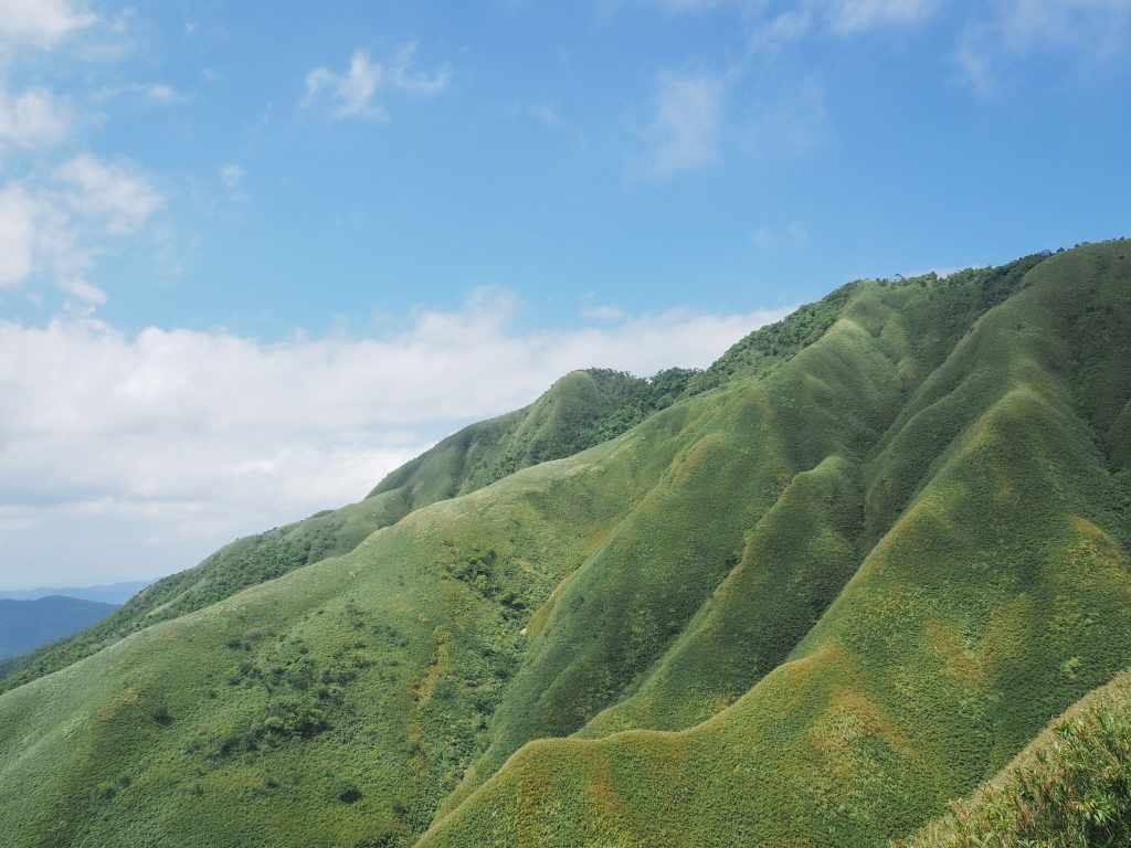
ENJOYMENT: If you’re looking for peace and quiet look elsewhere. However, this is a fun leg-stretcher with some spectacular views. The folded green hills that made Matcha Mountain famous are really rather special.
SOLO HIKE-ABILITY: This is a great solo walk. (Although you won’t really be alone.)
OTHER: A hiking stick can help take some of the impact off knees and feet coming down. Also, you might want to consider taking gloves for the ropes (I was fine without).
TAIWAN 100 MINOR PEAKS: No. 83 – Mount Sanjiaolun
ROUTE TYPE: There and back.
PERMIT: None needed.
Jump to the bottom of this post for a trail map and GPX file.
DIRECTIONS:


The bus drops you off at the main carpark for Wufengqi Scenic Area and from there you need to head up past a row of hot spring places, some of which look rather swanky and others have definitely seen better days.

The pooled waters of Dezikou River looked cool and inviting despite the lateness of the season and earliness of the day.


Above the check dams, the river spreads out in a broad area with grassy banks and shallow enough to paddle in. Follow the road straight from here until you spot this red sign directing you right. Turn off the road and onto the path.

There are several side trails cutting up to the road and they’ll all take you to the same place in the end, but I stayed on the path that stuck close to the stream.


The path emerges at a collection of roadside stalls and another bathroom block. Even on a Monday morning, the area was pretty busy. Take the track leading uphill (it’s all uphill for a long way), then cross over a stone bridge and take the steps on the right leading up.

At the next junction, keep right again. All of these left turns can get you to the church a little quicker, but in doing so, you’d miss the waterfall.


You’ll know that you’ve arrived at the waterfall when you encounter this pavilion perched on a rock. In fact, there are three waterfalls clustered in Wufengqi Scenic Area. This is the second of the three, both in terms of placement and in size. The first and uppermost waterfall is the tallest and the third one further down the stream is less impressive.


After enjoying the moisture-filled breeze from the waterfall, I turned back to continue my journey. At the first junction (not pictured), take the righthand trail instead of heading back down the same route you came from. At the next junction (left photo here), you’ll need to choose whether or not you want to climb up to the first waterfall. (If you’re worried about how much time you have, I suggest you leave this diversion until you’re on your way down.) To continue onwards to the Matcha Mountain Trail, take the flatter path on the left which should be signposted as heading towards the church. The trail emerges onto the road at the tip of an 180° bend. Take the righthand, uphill track.

If you keep heading uphill on the road, you’ll soon find yourself at the Catholic Our Lady of Wufengqi Church. The church is a pretty circular building which sits among a small complex including accommodation for the nuns and a grotto that was built at the spot where the Virgin Mary allegedly appeared to save a group of travel-weary hikers in November of 1980. If you walk into the church, there is a high chance that you’ll be accosted by one of the friendly local volunteers. The church also has a clean toilet block and water dispenser, so it’s a good point to stop and make sure you’re toileted and hydrated.


If you’re all set, just keep following the track onwards and upwards. If I’m behind entirely honest, this portion of the walk is not particularly noteworthy. The passage of time and distance is marked by posts every 500m.


Aside from that, the only points of note are the two stream crossings, a rest area, and a basic toilet block.

At the 4km mark, you’ll find this stylised cross indicating the start of the proper trail portion of the walk. Aside from being a little monotonous, the second major drawback of having several kilometres of track to walk before the serious climbing starts that your muscles are already starting to tire just as you need to ask them to work harder.

The spot is also marked by a shelter with a toilet and some statues of the Virgin Mary, one of which is rendered in crumbling concrete.

This is the third time I’ve walked this trail, and each time, I forget how pretty the stream-side portion is. The path shimmies its way up alongside a boulder-strewn watercourse with numerous small cascades.


An omamori (lucky amulet, usually picked up in temples) attached to a tree, and one of the small waterfalls seen along the way.

10:46 – Once you’re on this part of the walk, there’s only one obvious turn-off. Here, a side trail on the right takes a less frequently traversed route up to Mount Sanjiaolun via Mount Wufengqi’s North Peak (被五峰旗山) and Mount Zhuzailun (竹仔崙山). I’ve never walked these trails, but it appears some hikers do walk a loop by travelling this way. The trail conditions appear far more basic than those on the main route though, so I wouldn’t advise it unless you’re well-prepared and looking for a challenge.

10:59 – There are distance markers every 100m once you swap the track for the trail. At the 0.7km mark, there’s a pavilion for hikers to rest in. Since my last visit, the shelter has been equipped with a defibrillator, first aid kid and a spinal board. I took a short break here and ate half of my sweet potato before continuing the climb.


11:18 – Around the 1km mark, there is a noticeable change in the trailside flora. The tree cover becomes more open and flocks of birds can be heard and seen flitting through the trees. I paused for a while to watch a mixed flock with Formosan scimitar babblers (they always seem to be the ringleaders of multi-species flocks), rufous capped warblers and grey-cheeked fulvettas.

The final change in the scenery comes when you’re nearing the top. Here, the taller tree cover disappears completely and the slopes are cloaked with short arrow bamboo shrubs. The view over the expanse of Lanyang Plain offers the perfect excuse to stop and catch your breath.

11:46 – After creating a final ridge, you will find yourself in a sheltered lee between two slopes.


There is a lotus pond full of noisy frogs, and to the right, statues of the Virgin Mary and Brother Luigi Pavan—an Italian who served in China and Thailand before moving to Taiwan. He is commemorated here because much of his time in Taiwan was spent serving in St. Mary’s Hospital in Luodong.

For most hikers, the literally high point of this walk is the platform just beyond the lotus pond.


This is where you get those spectacular views of windswept and velvety hills.

On the short climb up from the pond, you walk past a series of images depicting the 12 stations of the cross, and at the very top, there is a statue of the crucifixion. When I arrived, there was a hiking group posing in front of it with big grins and thumbs up. The incongruity gave me a little chuckle.

From there, I made my way back down to the pond and then followed the path up towards the hut. There are toilets here and benches outside. It’s about the only shady spot up here, so I joined the other hikers to eat the rest of my sweet potato and some fruit bars. The trail leading up to Mount Sanjiaolun starts just to the left of this hut.

12:11 – As you can see from the steepness of the very first climb, this is a little more serious than the previous part of the trail, and for this reason, you’ll likely see far fewer people.

12:18 – After a brief steep initial climb, the trail eases off for a while and winds around the slope until it reaches a junction. (This is where the alternative trail passed at 10:46 rejoins.) Two trails lead straight up the hill to the left of this spot. It doesn’t really matter which of the two you take. Both head towards Mount Sanjiaolun and both are steep.


12:30 – The climb up is really steep. You need to pull yourself up using the ropes. It took me about ten minutes to climb up to Mount Sanjiaolun’s Southeast Peak.

12:40 – From the southeast peak, it takes another ten minutes of battling through encroaching bamboo to arrive at the summit of Mount Sanjiaolun.


The summit is marked by a small clearing with a triangulation post and a metal sign. And if you look out towards the coast, you can see Turtle Island.


Since I arrived at the (completely exposed) peak at the hottest part of the day, I didn’t hang around. From here, it took me about 25 minutes to retrace my steps back down to the hut and the lotus pond. And after another brief snack at the hut, I began my descent.

An elegant five-lined skink seen on the way down. I’ll never get bored of seeing these flashes of electric blue.

13:33 – I made good time on my way back down and was at the first shelter by half past one.


13:47 – About a quarter of an hour later, I was reaching the end of the trail and only had the track left to walk. Along this stretch, I fell in step with a retired teacher whose umbrella was the exact same combination of grey and yellow as mine. Although he went to uni in Taipei, he said the rest of his life was spent in Yilan and since he retired he makes the pilgrimage to the top of this trail at least three times a week. “If you don’t use it, you lose it.”

14:21 – When we reached the church at the bottom, my new friend bid me farewell and I continued down the road alone.

As you walk down past the church, you can catch a final impressive glimpse of the uppermost of the Wufengqi Waterfall cluster.


Making my way back down past the check dams, I saw one local enjoying the water’s cool embrace in open defiance of all the signs warning you not to. I was back at the bus stop just a few minutes before the next bus to Jiaoxi Transfer Station was due to depart. Since I finished so early, I decided to head home and enjoy dinner with Teresa, but if you’re not pressed for time, I advise riding the bus all the way back to Jiaoxi Train Station and getting some refreshments there.
HOW TO GET TO MATCHA MOUNTAIN
Google Maps address: The walk starts from Wufengqi Parking Area. It currently costs $50 per car and $20 for a scooter to park here.
GPS location: N24 49.940 E121 44.810
Public transport: You will need to arrive at Jiaoxi Transfer Station before the connecting bus departs. Buses leave various parts of Taipei bound for this bus station. I caught the 7:15am Kamalan bus from the Technology Building bus stop (NT$112, tickets are bought from the booth before boarding). From Jiaoxi Transfer Station, take the GR11 A Taiwan Tourist Shuttle and ride it to Wufengqi Scenic Area bus stop. The bus has extremely infrequent services, so you can basically only take the 8:50am bus.
Nearby trails:
- Linmei Shipan Trail
- Paoma Historic Trail
- Tamsui-Kavalan Trails: Dali to Yilan
- Tamsui-Kavalan Trails: Qingyun Bridge to Jiaoxi
- Wufengqi Waterfall Trail
My new words learnt on this hike:
- 氧氣 / yǎngqì / oxygen
MATACHA MOUNTAIN TRAIL MAP

GPX file available here on Outdoor Active. (Account needed, but the free one works just fine.)

MATCHA MOUNTAIN and MOUNT SANJIAOLUN (抹茶山/三角崙山)
I hiked the trail in Feb 2020, less than a month before COVID wrecked worldwide travel.
Yes, I particularly enjoyed the hike and reading your article brought back fond memories.
A pleasure to buy the 2 COFFEE, a small Thank You gesture.
LikeLiked by 1 person
Hi there, thank you very much for that! I’m really pleased to hear that reading about this trail brought back some happy memories of your time in Taiwan. Perhaps it’s time for a return trip now that the risks posed by Covid are diminished.
LikeLike