A Watery Walk in One of Yangmingshan National Park’s Restricted Areas
I’d been hankering to try out the updated Yangmingshan National Park permit system ever since it went live last year, but you know how it is, there’s always something else to do. So when Travel in Taiwan Magazine asked me to write about Lujiaokeng Ecological Protection Area for their July/August 2023 edition, I jumped at the opportunity it would provide me to see how the application system works. I’d also long wanted to visit this protected area. It flies under the radar as a place to visit, but this remote spot is a really pretty part of Yangmingshan National Park.
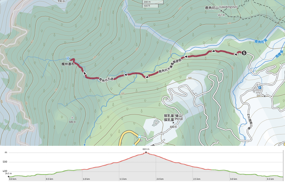
Distance: About 4km from the guard station to Fenglin Waterfall and back. (8.3km if you walk to and from the bus stop as well.)
Time: The Yangmingshan National Park website suggests this route should take you three to four hours. We walked it in about 3½. If you’re coming on public transport, you’ll need to add an extra 45 minutes in each direction.
Difficulty (regular Taiwan hiker): 4/10 – Applying for a permit, getting to the trail, slipperiness, and the lack of signage put this on the harder end of easy.
Difficulty (new Taiwan hiker): 5-6/10 – This would be a logistically tough walk to figure out if you’re new to Taiwan. But not impossible. As long as you prepare and go well-equipped, it should be doable.
Total ascent: Around 270m. Once you’re off the road, the trail actually climbs quite steeply.
Water: We took 0.5L each as well as some snacks to enjoy once we reached the waterfall.
Shade: Once you start the trail portion, it’s pretty shady, but the walk to the pumping station and fish ladder is more exposed.
Mobile network: The further in you go, the weaker the signal. There was none at all by the waterfall
Enjoyment: This is a beautiful walk in pristine surroundings. If you’ve got the patience to apply for it, I’d highly recommend you make the time.
Other: You’ll need to wear wellies or maybe river tracing shoes if you find those comfortable to walk in (although if you opt for these, then it would make sense to change into them once you get to the pumping station). Additionally, trousers are probably a far better choice than shorts (we encountered a leech or two), and gloves will give you more confidence when grabbing onto things. Finally, if the weather is bad, cancel your permit and go again another day.
Route type: There and back.
Permit: This trail requires a permit, and a condition of the permit is that you purchase hiking insurance. You can follow this step-by-step guide to apply for a Yangmingshan Hiking Permit, and this one to apply for insurance.
Jump to the bottom of this post for a trail map, GPX file, and transportation information.


When we arrived at the ranger station, we were asked to show our permit and ID documents. The rangers here are all volunteers. I really don’t know how I feel about this. On the one hand, it is lovely to know that there are kind-hearted nature lovers willing to devote their free time to ensuring others can access Taiwan’s green spaces, but on the other hand. Shouldn’t this be a paid position? I guess this is how places like Yangmingshan can operate without charging visitors and entrance fee.

With our documents approved, we were asked to rub any mud off of our boots before the rangers unlocked the gate to let us in. (The purpose of this is to remove any “foreign” seeds or diseases from your shoes so that the reserve’s ecosystem is not affected.)

The first half of the walk is a steadily uphill stroll along a track used by workers visiting the water plant. It passed very quickly. So much so, that on the way down, I had forgotten just how long it was.

An old boundary marker at the side of the road. This one looks like it’s had a new lock of paint.


After twenty minutes, we arrived at Lujiaokeng First Pumping Station. The bottom end of the fish ladder that some people come to visit is located on the right, just before the pumping station. To start the off-road portion of the walk, head around the back of the building and keep going.

A brief detour to look at the top end of the fish ladder.


The start of the trail was marked by this old traffic cone, and beyond it, we quickly got a taste of what was to come.

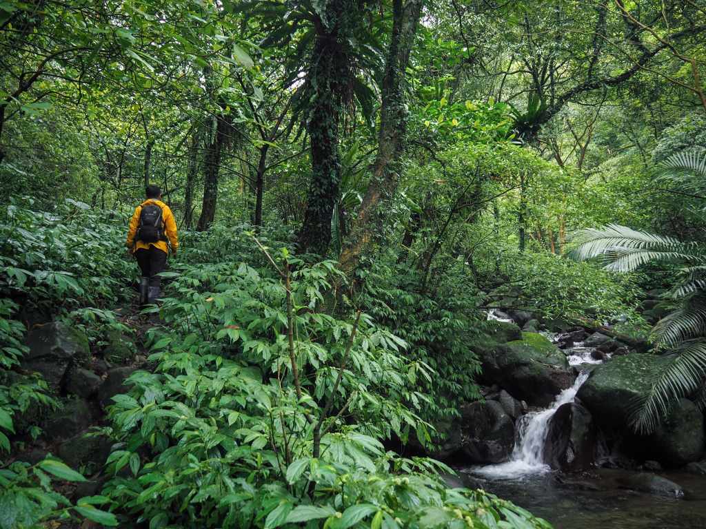
The reason I recommended that you wear wellies is that this walk includes a lot of stream crossings. The water wasn’t much higher than ankle-deep in most places, but occasionally it reached half-way up my calves.

Overgrown stone walls beside the trail hint that this area may once have been settled. According to Tony Huang’s post on this area, the path used to connect Jinshan with Beitou in the 1800s (although time and weather have erased much of it from the landscape).


Even when it isn’t crossing the steam, the path never strays far from the water. Moss and ferns grow in abundance in the shady stream valley.

It’s no exaggeration to say that I had to stop to appreciate the prettiness with each turn in the trail.


This guy is a sign that the area is free from pollution. These carnivorous hammerhead worms (Bipalium nobile) tend to be found in only very clean habitats.

Something I found interesting about this trail is that the park authorities decided against installing any signs. And since it’s a protected area, that means no tying up plastic hiking tags either. The workaround is these cairns. Built by both park rangers and other travellers, some are elaborate, others are just a couple of rocks in a pile. I know there’s a growing emphasis being put on not making land art (or destroying it before you go) in the LNT philosophy, but in this context, the cairns make sense. They silently beckon you across the water and up hills without leaving any lasting mark on the land.


Contemplating a climb which took us right up beside a small waterfall.

The final push up to Fenglin Waterfall is the steepest part of the whole walk. (I could feel the echoes of my efforts in my sore rib muscles the following day.)

When we arrived at the waterfall, there was another group there having their lunch. They’d snagged the larger of the resting spots, but that meant we got the one with the best view!


As we ate our fruit and watched the water, Teresa spotted this leech that had attached itself to her boot. Fenglin Waterfall (楓林瀑布) can also be translated as Maple Forest Waterfall, and the spot certainly lives up to its name. There are several maple trees towering above the stream at this point, although in April, the leaves were a bright green:

We spent about forty minutes in the little clearing with Fenglin Waterfall listening to the sound of water and birdsong and breathing in the sweet forest-scented air.

To get back to the start, we retraced our steps over and around the stream, taking extra care not to slip on the algae-slick rocks.


I’m not precisely sure what either of these photos shows. The one on the left is obviously some type of weeping fungus, and on the right there are obvious signs of some of the park’s wildlife.

It took us about 45 minutes to return to the last crossing right before the pumping station, and then another 15 minutes to walk to the gate.

The gates are locked, so we had to make a little bit of a noise to get the guards’ attention before we were released. My only regret is that this is such a short walk. I would have loved for it to have continued.
How to get to Lujiaokeng Ecological Protected Area
Google Maps address: The walk starts from Lujiaokeng Ranger Station. There is space for cars and scooters to park here.
GPS location:
- Spot where you need to turn off the main road – N25 11.035 E121 34.405
- Lujiaokeng Ranger Station – N25 11.520 E121 34.055
Public transport: Catch the 1717 towards Jinshan. This service picks up at Taipei Main Station, Jiantan Station, and several other spots in between. Ride it all the way to Xiaqigu bus stop, get off and walk to the ranger station (about 45 minutes).
Further reading: You can check out the little section I did on this trail for Travel in Taiwan Magazine here.
Nearby trails:
Lujiaokeng Ecological Protected Area Trail Map
GPX file available here on Outdoor Active. (Account needed, but the free one works just fine.)
