
Dabang is a village of many names (or perhaps, many spellings). Named Tapangu by its Tsou inhabitants, romanised versions of the Mandarin name include Dabang, Dapang, Tapung, and probably others that I’ve missed. With a population of around 900, it’s not especially big, but it has more than enough amenities to make it a pleasant place to spend a night or two. There’s a museum dedicated to sharing the life and culture of the Tsou, several restaurants and cafes, a couple of convenience stores, some B&Bs, a school, and a couple of short walks.
The trail detailed here is a short loop just on the edge of the settlement that climbs to a pavilion with cultural significance for the village’s inhabitants.
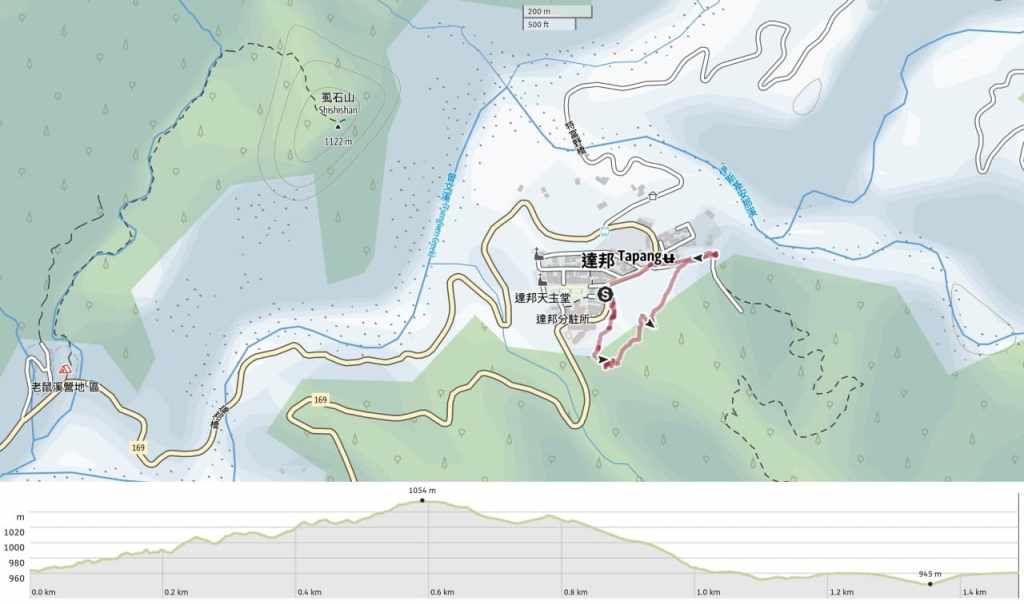
Distance: 1.5 kilometres.
Time: 30 minutes to an hour should be ample.
Difficulty (regular Taiwan hiker): 2/10 – Some elevation gain and a cluttered path.
Difficulty (new Taiwan hiker): 3-4/10 – For someone new to Taiwan’s hiking trails, the steepness of both the ascent and the descent might come as an unpleasant shock. But despite that, the shortness of this route means it should be on the tougher end of easy for Taiwan hiking newbies.
Total ascent: A little over 100 metres.
Water: I just took a small 0.5L bottle. The Tsou Cultural Exhibition Centre has a water dispenser where you can top up if necessary.
Shade: Mostly quite well-shaded.
Mobile network: Clear throughout.
Enjoyment: This trail offers short and pleasant way to stretch your legs before tucking into some tasty Tsou cuisine at the nearby tribal restaurant.
Bathroom facilities: There’s a toilet block at the end of the trail (which is just 50 metres from the start of the trail).
Route type: Loop
Permit: None needed
Jump to the bottom of this post for a trail map and GPX file.


The Niaozhan Pavilion trail starts from Dabang bus stop, right outside a wonderful Tsou tribal restaurant and across from the school’s sports field.

Steps zigzag up through a forest dominated by Japanese cedars and the wind makes its presence felt by rattling the bamboo.

In the understory, giant elephant ears and bananas catch the filtered sunlight, while the fronds of the Taiwan sugar palm quiver and dance in the breeze.

Unlike the trails around Taipei, which are swept free of leaves by helpful volunteers each morning, this trail has gathered a layer of cedar duff.

One gap in the trees exposed the red span of Fugue Bridge.


Shortly after passing the 300-metre marker, the trail levels off and passes through an area with a couple of pavilions and benches before descending.

Unlike the steps of the ascent, the ones leading down are wooden and raised just off the ground.

At the bottom of the steps, there is a view over to the far side of the valley, and here the path starts to follow a steep track.

The middle part of the track has been made into steps, making it slightly easier to traverse.

Just before the track loops down to rejoin the road, a short side trail on the right leafs to the Bird Divination Pavilion.

The pavilion is a four-sided thatch-roofed affair and in front of it, there’s a circular stone structure with a knot of bamboo placed in the centre. The Tsou of Dabang hold that one of their ancestors, a man named Oazmu was transformed into a bird upon his death. The man knew this would happen and told his tribesfolk that they should listen to his voice before setting off to hunt or wage war. The bird he was transformed into was the grey-cheeked fulvetta (also called the grey-eyed nun babbler). If the bird’s calls are lower than usual, or if it seems agitated in its movements, it is a bad omen and the hunt should be called off.


From the pavilion, I took the road leading back down towards Dabang Village.
How to get to Dabang
Google Maps address: The walk starts and finishes beside the bus stop in Dabang Tribal Village. There’s space to park cars and scooters immediately opposite the trailhead in an open space in front of a restaurant.
GPS location: N23 27.245 E120 45.015
Public transport: This route is served by the 7314 bus which runs between Chiayi County Daya Bus Station (starting point) or Chiayi Train Station (pick-up point along the way) and Dabang bus stop. However, online sources seem to disagree quite significantly as to how many services there are and when they leave. From what I can tell, this is because the departure times vary depending on whether you travel on a weekday or weekends.
To the best of what I can ascertain, on Mondays to Fridays, two buses travel in each direction daily, leaving Daya Bus Station at 05:45 and 16:55, and returning from Dabang (this terminal stop is just a couple of hundred metres along the road from the Tefuye Entrance stop) at 08:00 and 19:10. On weekends, there are also two services in both directions. They leave Daya Bus Station at 10:55 and 16:55, and return from Dabang at 14:10 and 19:10.
The ride up takes about 2.5 hours, so although it would be possible to travel here for a day trip, it would be a far more enjoyable experience to plan an overnight stop in either Dabang or Tefuye. This would allow you to have time to sample the excellent Tsou cuisine on offer at places like the Tsou Fengguan Tribal Restaurant.
Nearby trails:
- Lijia Romantic Cave Trail
- Tefuye Trail and Giant Camphor Tree Grove
Dabang Bird Divination Trail Map
GPX file available here on Outdoor Active. (Account needed, but the free one works just fine.)
