
Visiting Giant Trees in Yilan’s Ancient Forests
I can’t remember how or where we first saw this trail, but it seemed like a perfect candidate for a long weekend car camping trip. As it transpired, it was more than perfect. The weather was ideal, the place we parked was quiet enough to get a good night’s sleep, and the forest was just overwhelmingly beautiful.
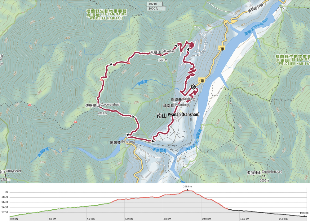
Distance: 15.5km – Only 6.2km of this is actually on the trail, the rest is on roads and farm tracks.
Time: This walk took us about 10 hours in total, but we are slow walkers. From trailhead to trailhead, it was about 7½ hours and the rest was road walking.
Difficulty (regular Taiwan hiker): 6-7/10 – This is a moderate-to-challenging day hike. The length and elevation gain are the hardest parts.
Difficulty (new Taiwan hiker): 9/10 – This would be very tiring if you weren’t used to the kind of trails found in Taiwan. However, it is not dangerous and the trail is easy to follow.
Total ascent: A little under 1,100m.
Water: We took about 2L each and both drank about 1.5L of that. You’ll also need plenty of snacks.
Shade: The forest part of the walk is very shady, but the farm track is extremely open. I got a little burnt on the walk down.
Mobile network: Between Zuodehan Shan and the hunter’s cabin, there was weak-to-no signal. Either side of that was OK.
Enjoyment: I loved this walk. The forest is so pretty and the giant trees are spectacular.
Camping: If you’re looking for a remote and wild camping spot, this might be a good spot. There are two campsites marked along this route. Both are primitive sites, but have access to water. It’s likely you’ll either have the sites to yourself or be sharing them with hunters.
Other: We decided to wear wellies because other writ-ups of this walk suggested that it would be possible to encounter boggy sections and leeches. We found plenty of the former, but luckily, none of the latter. There were many points at which I was glad of the extra cover, but you’ll want to make sure that you’ve got good insoles in them so that your feet service the LONG walk down the track at the end.
Route type: Loop
Permit: None needed.
Jump to the bottom of this post for a trail map, GPX file, and transport options.


6:30 – We slept in our car by the side of the road between the two convenience stores in Nanshan Village, waking up at about 5:30. When we emerged, the Family Mart (which is 24-hours) was open, as were a couple of village stores selling buns and other snacks. We ventured to the convenience store to use the toilets and grab a coffee before setting off. As we were getting ready, so too were many of the farm workers. This spot seems to be their staging post before they head out into the fields. By the time we started our journey by passing the 7-Eleven, it had opened too.

06:42 – As we rounded a bend in the road, we saw the first rays of the sun touching one of the peaks beyond Nanshan Village’s graveyard. It was around here that one of the cabbage farming trucks pulled over. In the driver’s seat there was an Aboriginal teen, and he called out to ask us if we were going to the red bridge and if we would like a lift. We said yes, thank you very much, and squeezed ourselves in as he apologised for the mess in the cab.

The journey in the truck was over in just three or four minutes, but it saved us about 20-30 minutes of walking. Our driver said that his grandfather had taken him up the mountain we were about to climb when he was younger, and he said he thought we were going to be tired enough without having to walk along the road to the start of the trail. When the kid dropped us off at Kefa Bridge (可法橋), he turned to us with a big grin on his face and asked us how old we thought he was. Teresa guessed 15, and was just a year off. Our driver was a mere 16-year-old baby. (The legal driving age in Taiwan is 18, but as with farming areas back home, it’s not uncommon to find the rules being interpreted in a more “relaxed” fashion up in these rural communities.)

07:05 – The start of the trail would be very easy to miss if you’re not used to hiking in Taiwan. On the Nanshan Village side of the bridge, some hiking tags have been tied to a branch above the road wall and a rope hangs down to assist you with climbing up the water pipes.

The start of the walk (as well as the end) is marred by ugly plastic piping. Many of the cabbage farmers appear to be sourcing fresh water straight from the mountain streams.


After the first initial climb, the trail appears to split in two. The route of the left isn’t present on the map we used. Instead, you’ll need to climb down to cross over the river before climbing up again on the far side. After this last little dip, we had spent the next three solid hours climbing.

Much of the climb was unrelentingly steep (save for a much-appreciated reprieve about halfway up).


Thankfully, although the ascent was steep and long, the forest provided endless welcome distractions. The ferns and mosses were so luscious and vibrant, and the light shining through the canopy made everything all the prettier. And this being an Area with a strong Aboriginal population, we also saw a fair few of these spent shotgun shells.

There are not many “view” views on this trail. (Although it more than makes up for that with forest scenery.) On the way up, there is just this one spot where you can see through the trees. If you shift to the right of where I took this picture, you can make out the bend where the bridge crosses Mimodeng River and where we began our climb.

The middle part of the climb was utterly spectacular. It was that kind of bright green forest that you only get in very humid places where the moss and lichen seem to drip from the trees.

Some of the lichens were like this, others were long strings, almost like the most delicate type of tinsel.

As we got closer to the first peak, we found ourselves walking up a fern-swamped ridge line.


In some places, the lichen hanging from the trees looked almost like blonde hair or rime.

10:17 – After three hours of intense climbing, we reached the summit of Mount Zuodehan (or Mount Qwasan Takay in the local Tayal language).

We took a twenty-minute break here to have a snack and rest a little before setting off again.

10:43 – About five minutes after we started walking again, we reached a junction. Keep right here and stick to the more defined path. The sign nailed to the tree says that the other route, which leads to Mount Tayafu (塔雅府山) is both long and unclear.

After descending for a while, we reentered the bright green mossy level once more. Considering how alive the forest felt, it was odd that we didn’t hear more wildlife. At this point, I think we could only hear a few birds.

11:10 – The first giant tree appeared at about the point where the trail levelled off and became flat-ish.


More green details. This type of moss seems to grow in lovely plump little tussocks which felt lovely to the touch.

To the right of the trail, we saw a water tank sunk into a natural hollow. It looks like maybe it used to be used by hunters or loggers, but it probably doesn’t serve any purpose anymore. Not much further along, there is meant to be a junction, however, we never saw it.


11:30 – A little further along, we came across a current water source. In the map, this spot is marked as being Shuilongtou Campsite (水龍頭營地). The Chinese name translates to “tap” and when we arrived, we could see why. One of the pipes has a tap so that hunters and campers can access fresh water while they’re out in the wilderness.

Between the two campsites, we came across numerous boggy stretches.

11:43 – The second giant tree of the walk (Nanshan Sacred Tree No. 8) is a Taiwanese cypress and was by far the most impressive of all the giant trees. A sign resting on the base of its trunk says that it is believed to be around 2500 years old. It’s so hard to conceptualise such a number. That’s roughly 100 human generations. This tree has stood there as Taiwan’s early civilisations spread and hunted in the forests. It was there when the first waves of Chinese settlers arrived, as the Portuguese took hold of Tainan, as the French attempted to invade, as the Japanese made Taiwan their colony. It has stood here just quietly, powerfully growing as humans busily live and die in the towns and cities below.

There’s a kind of perception overload or computational error which always seems to affect me when I see giant trees like this. I always want to get close to them. As if touching them will allow me to know the vastness in a way that my eyes alone cannot. But when you get that close, it becomes impossible to see more than the tiniest fraction of what’s in front of you.

11:52 – Just after leaving the tree’s clearing, we came to another junction. Both trails will soon connect up again, but if you want to see the giant trees, take the one on the left.


Leaving the trees clearing, we found ourselves following more ugly water pipes. There were other signs of prior human incursions too, like this teapot that had started growing into the tree that was holding it.

More boggy ground. By this point, I was really starting to appreciate that we’d decided to wear boots.


The next giant tree (Nanshan Sacred Tree No. 4) had grown in a way that allows you to walk through and underneath it. And the one after that had a sign beside it which said that it had been partially cut by illegal loggers in 2012. (The wood of giant cedar trees

12:13 – Teresa skirting around a muddy puddle about five minutes before we arrived at the last of the giant trees.


In a flat area just beyond the last giant tree, we heard a rhythmic tapping sound coming from somewhere high above us. Several minutes of peering at the leafy branches revealed two species of woodpecker hanging out on the same tree. The one on the left is a white-backed woodpecker, and the one on the right is a grey-headed woodpecker. This isn’t the first time I’ve seen or heard woodpeckers in Taiwan’s forests, but it’s the first time I’ve seen them clearly enough to be able to identify what I’m looking at. (We saw another grey-headed woodpecker later on, too.)

12:57 – This is the point at which the alternative trail from earlier (at the 11:52 mark) reconnects. Teresa breezed straight past without even seeing it, but if you look carefully, there’s an obvious trail joining on the right.

13:00 – The trail reaches a clearing which looks like it would make a good campsite. The path continues left out of the clearing, but if you head straight…

… you’ll soon arrive at this hunters’ cabin. It smelled of woodsmoke inside, and a drawing above the door depicts an Aboriginal hunter chasing a wild boar. We stopped here for a while to have the rest of our lunch, then carried on.

Shortly beyond the hunter’s cabin, we were given a bit of a scare. Simultaneously, some type of pheasant got startled by our presence and went crashing clumsily through the undergrowth AND a leaky water pipe that sounded uncannily like a screeching beast decided to start up its hissing and squealing. The pipe truly sounded horrific.


13:29 – There are two more junctions before you reach the end of the trail. In both cases, you need to keep heading straight/left as side trails head away to your right. These lead over the border with Hsinchu into Shei-pa National Park, and towards Bianbai Pool (扁柏池), and look to be a very long, very tough walk.

As the trail begins the final descent to Mount Milou, there are a few more views to be enjoyed.


This section of the trail is by far the most “scary” in that it follows a sharp ridge with drop-offs on either side. For the most part, you never feel too exposed, but this is certainly where I felt the need to be extra sure of my footing.

13:47 – At one point, the trees on the left side of the trail disappear entirely and you get a clear view over the valley to the next ridge. The one slightly obscured by clouds on the left of the photo is Mount Manao (馬惱山), the middle cloudy peak is Mount Meiyouyan (眉有岩山), and the knobbly one on the far right is Mount Xiangben (香本山). In clearer weather, you can see Mount Hongludi (we visited this while walking part of Tonghou Stream Trail).


14:09 – After such a beautiful walk, the summit of Mount Miluo was a bit underwhelming. We passed straight through the clearing without stopping.

14:23 – From Mount Miluo all the way down to the point where the trail emerges onto farm tracks, there are old wooden steps.

And when you finally break through onto the track, the views are spectacular.


It’s really rather lucky it’s this beautiful, otherwise the 2-hour slog back to Nanshan Village would be mighty dull. We saw lots of bird life along the way down, including my first ever sighting of a mountain hawk-eagle and lots of cute Taiwan yuhinas. We also saw a lot of very questionable farming practises.

16:06 – Follow the track all the way down until it rejoins Provincial Highway 7C, then turn left and head uphill.


16:30 – This part was exceedingly unpleasant on account of all the many tour buses and blue trucks, but thankfully it was soon over.

At the risk of ruining a very lovely post about a very lovely part of Taiwan, our day’s walking was marred by some unpleasantness. While walking down the farm track and along the road to where we parked, we experienced the crappy side of rural life in Taiwan. There were chained up animals which looked to be underfed, and many literal waterfalls of rubbish. The sad thing is, this seems to be mostly perpetuated by the very people who live and work in this place. I don’t know what the solution is, but something really needs to be done. This really isn’t an acceptable way of dealing with rubbish.
How to get to Nanshan Village
Google maps address: We parked beside the road between the 7-Eleven and the Family Mart. There are no actual parking spaces, but there were several free spots.
GPS location:
- Parking – N24 26.385 E121 22.775
- Kefa Bridge Trailhead – N24 25.830 E121 21.830
Public transport: It would be possible to do this using public transport, but unless you are a fit trail-runner, you’ll probably also want to spend at least one night in the village.
- From Luodong Transfer Station – The 1764 via Wuling Farm leaves at 7:00am and arrives at the Mimodeng River bus stop around 8:50 (it passes through Nanshan, but if you have already brought provisions with you, there’s no need to walk along the road). For most speedy people (speedier than us), that would be enough time to at least get on the farming track before dark.
- From Yilan Transfer Station – The 1751 bound for Lishan leaves at 7:30. It also arrives at Mimodeng TRiver bus stop, but it would get you there a little later.
- Returning – The 1764 leaves Nanshan Village at about 14:24. The two 1751 buses leave at 9:56 and 14:56.
Staying in Nanshan: There are a couple of minsu-style guesthouses in Nanshan. Hayong’s House (哈勇的家), phone number: 0926 093 603. And Nazhu Homestay (拿住接待家庭), phone number: 0958587735. We didn’t stay in either, so I can’t comment on them.
Further reading: For a Chinese explanation of the route, check here.
Zuomi Trail Map
GPX file available here on Outdoor Active. (Account needed, but the free one works just fine.)
