I actually climbed Guandao Mountain in the course of hiking the Raknus Selu Trail. However, I feel like the kind of people who just enjoy climbing big hills or even the kind of people who like tackling challenges such as climbing the Xiao Bai Yue are a little different to the kind of people who would want to walk the whole of the RST, so I will write about both experiences as if they were separate. If you’re interested in finding out more about that particular long-distance trail, you can do so here.
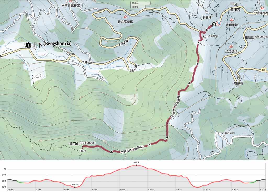
DISTANCE: About 4.6km.
TIME: 3-4 hours – It took me a leisurely 2 hours to reach the summit, but I certainly could have walked quicker.
TOTAL ASCENT: A little under 300 metres to a high point of 889 metres above sea level.
DIFFICULTY (REGULAR TAIWAN HIKERS): 2-3/10 – On a cool, dry day, the conditions made this walk easy and pleasant. In damp weather, it would likely be very slippery.
DIFFICULTY (NEW HIKERS): 4/10 – For new hikers or hikers new to Taiwan, I think this walk would probably belong at the uppermost edge of the easy category. There are steps and a few steep climbs, but no scrambles that require the use of hands. It’s also easy to follow and relatively short.
SIGNAGE: There isn’t much signage along the way, but once you’re on the path, there is only a single trail to follow, so there is little chance of going astray.
FOOD AND WATER: I would say a single regular 0.5-0.7L bottle is ample in cool weather.
SHADE: There is patchy shade along most of this route.
MOBILE NETWORK: Clear signal throughout.
ENJOYMENT: This is certainly a great Xiao Bai Yue. It’s a lovely length, pretty, and the trails themselves are pleasant to walk.
SOLO HIKE-ABILITY: There’s nothing to make this walk particularly risky for a solo hiker., no drop-offs or tricky sections, or anything like that. Although I didn’t see anyone on my Monday morning visit, I suspect it’s busy on weekends.
TAIWAN 100 MINOR PEAKS: Number 36
ROUTE TYPE: There and back.
PERMIT: None needed.
Jump to the bottom of this post for a trail map and GPX file.
DIRECTIONS:

This walk starts and ends at Ginger Garden, another of Taiwan’s specialised agritourism hotspots. In this case (as the name suggests), the region’s esteemed product is ginger. According to the hype, the ginger grown here is known for being especially plump in form and having a mellow flavour that makes it suited to brewing ginger tea. If you want to sample it, make sure to stop off at the visitor centre where you’ll find a big silver vat of hot, sweet tea that travellers can try for free. In addition to ginger, this spot is also known for producing peaches and plums, and being a great spot to watch a sea of clouds lap at nearby peaks.


Naturally, as this is a tourist spot, you can expect to find plenty of cute ginger-related mascots and the like.

From the carpark, walk back down the road away from the temple until you arrive at this farm/campsite track. Turn onto the track and follow it towards the trees. (There’s a great vegetarian restaurant about 50m further down the road from here.)


At the junction, take a right and keep heading down until you find yourself at the trailhead.

Take the steps heading up in the middle of a farm track.


There was some lovely bright sunlight on the day I visited this trail, and it shone through the upper canopy in bright shafts to illuminate details like these ferns and glowing fungus on the forest floor.

The plant life that you’ll encounter on the trail is generally quite mixed, with some sections that are dominated by this type of skinny bamboo.

If you look up, you’ll find the bamboo dwarfed by several species of taller trees.

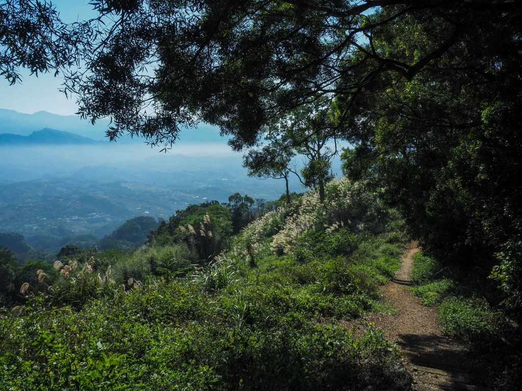
About 20 minutes after setting off, I arrived at one of the walk’s two great vantage points. (The second one is at the summit.)

The last vestiges of the early morning sea of clouds were still clinging to the lower reaches of the valley and bright winter sun made the last of the season’s silvergrass pop against the greenery.


After the trees swallow you up again, the path tracks down to cross over a farm track (perhaps the same one as earlier, I’m unsure).

The next portion, from the junction to the peak, has the steepest parts of the walk. (And also the muddiest.) Along the way, you’ll find lots of spots that have been shored up by the folks from Taiwan Thousand Miles Trail Association.


This right here should give you at least two reasons to walk this particular trail. The path is exceptionally pleasant and the views (when they arrive) are great too.

The moss seemed to be pushing out through each and every crack in this tree’s bark.


Sunlight picking out pretty details on a banana palm leaf and an epiphytic fern.

Close to the summit, the path starts to become just a little bit more gentle in its incline.


More beautiful greenery details. On the left is the underside of a fern, and on the right are some clover(ish?) leaves that sparkled with the teeny-tiniest dew droplets.

As you approach the high point of the walk, the trail narrows to run through a tunnel of slender bamboo.

As with all of the vantage points lower down on the trail, from the summit, you can see mostly north and somewhat eastwards. The first tall peak that’s visible is Jiali Mountain, another of the Xiao Bai Yue. Also clearly on display was the horrible, thick, hazy layer of air pollution that hangs over much of western and northern Taiwan in the winter months.


You can also see back over to the start of the walk (look out for the Cloud Viewing Tower to get yourself oriented), and in good weather, you can see over to the Holy Ridge (聖稜線) stretching from the knobbly twins of Dabajian Shan (大霸尖山) and Xiaodajian Shan (小霸尖山) all the way up to Snow Mountain. I happened to be doing this walk on a particularly cool day in December, and there were visible patches of snow caught in some spots.

The peak’s summit marker and triangulation stone sit in the northeastern corner of the spacious mountaintop clearing. On my weekday morning visit, I had the entire trail to myself, but I suspect that weekend visits would be a lot louder.
From here, you can either retrace your steps and head back down the same way, or else take the path leading down the far side of the mountain and turn left onto the road once the farm track joins a road. I headed straight over because, as I stated at the top, I visited this peak in the course of walking the Raknus Selu Trail, but quite honestly, I think returning the same way would be the prettiest choice.
HOW TO GET TO GUANDAO MOUNTAIN
Google Maps address: The walk starts and ends at Ginger Garden in Miaoli’s Dahu Township. There is a large free carpark at the trailhead.
GPS location: N24 23.130 E120 49.335
Public transport: There are no buses to or from this trailhead, so you’ll either need to sort out your own public transport.
GUANDAO MOUNTAIN TRAIL MAP
GPX file available here on Outdoor Active. (Account needed, but the free one works just fine.)
