This easy (almost entirely flat) bike ride takes you from the heart of Taipei out to Daxi, Taoyuan’s hilltop Hakka town famed for its dried tofu.
Distance: 40km – This could be easily extended if you want to cycle back or start elsewhere. And it could just as easily be shortened.
Time: 6 hours at a tourist pace (if, like me, you still to photograph everything of interest). This also includes a half-hour snack stop. I am sure any serious cyclist could probably halve that time. quicker
Difficulty: This is a pretty easy bike ride. There are no hills, just a couple of bridges, and you’re following well-paved bike paths the whole way. My butt didn’t even ache the next day.
Total ascent: Almost 300m. Some of that will be climbing bridges, the rest is the barely noticeable gradual ascent as you head upstream.
Water: I drank about 1.5L on a hot September day. There are places to stop along the way if you need to replenish your provisions, but all of them will mean diverting from the bikeway.
Shade: Pretty much no shade. I wore a hat with a neck cover and protective sleeves. Consequently, I ended the day with a stupid-looking 1cm band of sunburn on both arms where the sleeves had fallen down below the sleeves of my T-shirt.
Mobile network: Perfect the whole way.
Enjoyment: I enjoyed the latter section of this ride more than the part through Taipei City. The riverside bike paths are all much of a muchness until you get out of the city.
Other: At the time I cycled this, Daxi only had docks for the original YouBike 1.0s (the orange and yellow ones). However, the 2.0 YouBikes seem to be spreading rapidly, so it’s possible you could ride either type of bike there by the time I get around to posting this on the site. Just make sure you check using the YouBike 1.0 and YouBike 2.0 maps before you go. It would suck to arrive there, only to find you have no choice but to cycle back.
Route type: Point to point.
Permit: None needed.
Jump to the bottom of this post for a trail map and GPX file.

I picked out the bike that was to be my trusty steed for most of my journey from the YouBike stand close to the Nishi Honganji Square (a fascinating location with a multi-layered history – more on that here), and my former stomping grounds. For one weird and uncomfortable year, my partner and I lived in an apartment just a couple of minutes walk away from here. We walked our dog over the historic space of the square.


Turning right onto Changsha Street, I began the process of extricating myself from the city streets. I passed the old entrance to our poky little apartment, passed the historic Wanhua Qingshui Temple with its newly refurbished wing, crossed straight over Kangding Road and followed Changsha Street until it terminates at Huanhe South Road and the looming expressway.

After crossing the road and turning left, I looked for the narrow entranceway that would give access to the riverside park. If you weren’t actively looking, you could easily breeze straight past Guiyang evacuation gate without even realising it was there.

Be careful heading through the gate. It lets straight out onto a scooters-only four-lane road, and I can assure you that those scooters zip past at an alarming speed. Once safely over the road, I turned left and started following the river upstream.

As I approached the first of many junctions, I found myself passing what seemed like an endless stream of kids from Fuhsiung School (some of them can be seen heading towards me on the right there). Many nodded politely. A few braver ones giggled a “hello” in my direction. I took a left towards Huaijiang Bridge, Banciao, and away from the constant flow of students.


The mass of concrete infrastructure with all its vastness and interconnectedness new ceases to astound the simple village girl in me. Up close it is even more awesome (properly awesome that is–instilling both fear and wonder), than in the photos. I took the sloping ramp up and followed the bridge as it crossed Xindian River.

In the middle of the bridge, I paused to right a blue beetle that had got itself stuck on its back, then continued to the very end where everyone was very well-behaved about dismounting before going down. In the middle of the descent, I doubled back and took the arm of the ramp heading back in the direction of the river.


At the end of the ramp, I turned left, heading under the bridge and towards the spot where Dahan River and Xindain River meet to form Tamsui River. For the next couple of kilometres, there is quite a lot of street art to be enjoyed along the flood defense walls.


These 3D pieces stood out (geddit?!). The one on the left had been fashioned around the mouths of overflow pipes, while on the right, a gorilla with a pea-shooter scales more pipes to shoot down hot air balloons.


One particularly fun set of images saw updated and Taiwan-ified versions of works by famous artists from different eras.


Venus has left her scallop shell on a barbecue, Georges Seurat’s A Sunday Afternoon on the Island of La Grande Jatte has been rather faithfully recreated–save for the addition of a watermelon to the picnic spread.


Elsewhere, figures from both the Buddhist and Taoist pantheon come together for what looks like a riotous last supper, and the Girl With The Pearl Earring rides off ahead of her friend who’s still adjusting the seat of a YouBike.


As the trail approaches the elegant twin arches of Crescent Bridge, I followed a more looping path that took me between some of the nature reserve’s ponds.

As with almost everywhere in Taiwan, there are stray dogs along the river paths. This black one was attempting to lead its packmate through the water to…somewhere. In the end, it gave up and retreated to dry land.


Stretching from about parallel to Banciao Station for several kilometres until the trail approaches Tucheng Station, there are lots of little pools, lotus ponds, and other wetland areas between the cycle path and the river proper. I spotted a fair number of bird watchers with their cameras perched at the edges of these pools waiting for a glimpse of something.

Part-way down, I encountered the goats next to Fuzhou Pet Park. The well-fed creatures do not seem too interested in interacting with their guests.


This section has some of the most impressive semiurban scenery. I enjoyed both the cathedralesque internal spaces of Chenglin Bridge and the hills of Sanxia District rising above the multi-layered squiggle of interlinking freeways and expressways.


One small section of Mazutian Riverside Park with an oddly placed mound has several of these sculptures of indigenous Taiwanese figures. It looks like they’re pairs with the male and female each from different tribes. On the far left, I think the girl is wearing Amis clothing. Next to her is a boy wearing what looks to be clothing worn by Bunun men. Then in the righthand photo, the neat black and white outfit looks like it might be from the Kavalan Tribe, and the boy on the far right I’m unsure of…if you know, get in touch.


As you make your way through the park, keep an eye out for Gancheng Bridge (柑城橋). This is where you need to cross over Sanxia River and Dahan River to start making your way down the left bank for a change.
I went wrong here twice. First, I just kept cycling down this side until I realised I was wrong, then on the second attempt, I only crossed over Sanxia River.

The first of the two waterways–Sanxia River–is narrow but seemed full and deep.


At the end of the first bridge, you’ll meet the aggressively winking figure of Red Yeast Baby (紅麴寶寶). A bit of digging reveals that Red Yeast Baby is kind of Shulin’s mascot, and can be seen in a number of places where Shulin borders other districts. Why Red Yeast Baby? Well, apparently Shulin is famed for producing red yeast rice. No, I did not know that either. It seems the figure has stirred a little controversy in this generally quite lowkey corner of New Taipei. Previous Shulin Mayor, Lian Ming-zhi (連明智) has grumbled about the unnecessary expense, claiming that back in his tenure as mayor (in the early oughts), he oversaw the creation of a mascot for Shulin, as did two more of his predecessors before was imagined into the world (at a not inconsiderable cost). Others have criticised the coquettish wink, and officials from neighbouring counties threw shade by asking “What kind of wa gui is this?” (Wa gui being a type of savoury local snack made of rice paste set into dish shapes and topped with a meaty, gravy-ish substance.) Whatever your opinion of Red Yeast Baby, just keep breezing straight on past and through the industrial area towards the second bridge.

Dahan River, unlike the narrow channel of Sanxia River, spreads itself over a wide expanse of flood plain. After the heavy rains brought by a couple of recent typhoons, the silt-murky waters were flowing fast and strong through a couple of interlinked channels.


There’s quite a bit of work going on between here and Daxi, so this was the first place where I had to deviate from my planned route. It should have been possible to access the riverside bike path without crossing the road, but instead, I had to cross over and carry on my upstream journey on the far side of the road. Cross under Ganyuan Bridge (柑園大橋), then take a sharp left and follow the trail closer to the water.

In truth, there is probably an infinite number of ways to travel through the trails in riverside parks, but where possible I chose to stick to whichever took me closest to the water. (In this case, that meant through the scooter-prevention cones.)


By the time I was cycling through Shulinhuanbao Riverside Park, I was very aware that I was no longer in the “city” city. Tall grasses sheltered the path from the winds and provided sustenance for vocal prinias, and when I got a glimpse of the river, I saw it shimmering with early-in-the-season silvergrass.


At one point, I picked up a pair of fellow cyclists, who (just like me) stopped at every junction to check they were heading the right way. After turning left at this junction, we soon found ourselves passing Hingcunyan Model Aeroplane Airport. As I cycled by, one was twisting mid-airy like a ballerina doing a pirouette, and another that looked like a fighter jet was being prepared for take-off.


Beyond the mini airport, the trail is swallowed by tall bushes once more, and it’s hard to see where you’re going. Just keep heading left at each turn though, and it’ll get you where you need to go.

There is really quite a lot of development going on over in this region of New Taipei. I passed at least two spots where I could see what I believe to be the skeleton of new MRT lines being constructed–like this bridge to the southeast of Yingge.

Take a left turn over Sanying Longyan Bridge, and cross Yingge Stream to rejoin the larger course of Dahan River. If you’re into sculpture-y things, you might want to take a diversion at this point to cycle through Yingge’s Ceramics Park, or even Yingge proper.


For a short way, the path follows Huanhe Road, before later turning off to go its own way again.

More signs of the rapid development taking place in New Taipei can be seen at Sanying Bridge, where the bright red arches and blue water pipe are now accompanied by a new MRT bridge as well as a dual carriage roadway.


A little further along, a second water pipe spans the river–this one dropping abruptly down through a concrete pillar. These two red spans are some of the most keenly visible features when viewing Sanxia from on top of the nearby Yuanshan Rock (the start of a great ridge walk). Before the cycle path meets back up with the road again, it passes the grassy expanse of Yingge Woodball Lawn (鶯歌木球場). I know very little about woodball, but it seems to be the Asian version of croquet.

Where the cycle path reconnects with Huanhe Road, I got my first vire of Yuanshan Lake. I’d seen it from high up on the hill before, but from this angle, it appears far larger.

The path sticks close to the water’s edge, and I found myself kind of hypnotised by the flatness of the wind-rippled surface. At the first junction, I turned left into a new-looking park, and was treated with the strange sight of many parrots being wheeled up to the top of a small hill.


There has obviously been a LOT of landscaping work done here in recent years. One feature I enjoyed was the collection of grumpy-faced oversized birds perched next to information boards explaining their habits and habitats. A sign adorned with pink blossom marks the border with Taoyuan County and I breezed straight past it to follow the waterfront trail.

At the far end of a long mound, take a left turn (straight ahead in this photo), and set off for a brief spin through Taoyuan’s chive-growing district.


I did not know that Daxi is home to another of Taiwan’s blooming agri-tourism hotspots but evidently, it is. And luckily for me, I managed to stumble into its peak season. If you look at contemporary maps, there’s something that looks like it was probably have been a low-lying island sitting in the middle of a broad alluvial flood plane. The sweet-potato-shaped landmass (really, it’s even more sweet-potato-shaped than Taiwan itself) is bordered by Dahan River on the southeast and Zhongzhuang Retention Pond the northwest (the local government has opted for Tongyong Pinyin with their sparkling new signage reading JhongJhuang Bank-Side Reservoir). Almost the whole of the “island” has been given over to farming–presumably the soil here is pretty nutrient-dense given its location.

A large number of the farms were growing Chinese chives. As a rural lass, it’ll always perplex me to see tourists travelling to view fields of ripening crops, but it’s a real phenomenon here (see this article I did with Taiwan Everything for another example of this trend). This specific crop is known for its delicate sprays of white flowers and has been christened “September Snow” by locals. Several fields had already been cut, and a couple were in the process of being harvested as I passed by. The aroma of freshly-cut stems of chives wafted off the fields , sweet, grassy and putting me in mind of tasty stir-fried dishes.


Chives weren’t the only crop though. Elsewhere I saw rice and other fields had been left fallow. Egrets congregated in nearby treetops to preen and get some shuteye.

By the side of the road, I spotted what I suspect to be a washing pool. A step has been built into the road beside the irrigation canal so that washers can sit to clean their clothing or vegetables. (I’m pretty sure the colour of the water is the result of the heavy rains that preceded my visit, I imagine that it usually runs clear.)

As I neared the southernmost tip of the sweet potato, the road drew closer Zhongzhuang Retention Pond until…


…I was walking right alongside it. If you look closely at the pylon in the lefthand picture, there is a wicker cloud structure growing out of the base. I later found out that this was an installation–one of many spread throughout the river parks as part of the 2022 Taoyuan Land Art Festival. At the far end of the extension pond, it should be possible to continue on bike trails, but they’ve been temporarily closed while another bridge is under construction, so I found myself taking a detour along the road.

When the road finally caught back up with the cycle path again, I was rather taken with this lovely bird hide.


The sides of the hide are made up of mixed open openings, semi-transparent panels and wooden slatwork. Looking out onto the pond beyond, I saw several (unknown) waterbirds and I got my first sight od my destination perched atop a hill. Seen from this angle with the church spire making it look vaguely European, Daxi feels like quite an unusual Taiwnese town.

At the junction, I went left, following my plan to stick close to the river just one more time.


The cycle path heads under Daxi Bridge before doubling back to cross over it. As I got closer to the bridge, I was able to spot the odd architectural flourishes that hint at its heritage. Although the current bridge is actually pretty modern (it was built in 2001), inspiration for many of the details incorporated into the design came from the older Japanese suspension bridge that once spanned the river at this point.

Looking downstream back towards where I’d started the day’s adventures several hours earlier.

Once on the far side of the bridge, you’ll need to cycle through Daqing Cave (it’s not a cave, it’s a tunnel, but that’s what it’s called so…), then keep going straight. (Later, I’d walk back this far to take the steps on the right up towards the town.)


Cross over the main road and pass Yuemei Shan Guanyin Temple, then head leftish behind the temple and head for Yuemei Visitor Centre, this was the only working YouBike stand in the vicinity at the time of my visit. I parked up, then walked back up to the town in search of snacks and a bus back to the city.
Getting there
Google Maps address: I picked up my ride for the day from a YouBike Stand close to Ximen and dropped it off in Daxi. At that time, Taipei City still had both the original YouBikes and the YouBike 2.0s. At time of writing, Taipei City no longer has any of the original YouBikes and Daxi hasn’t yet got YouBike 2.0s, so that complicates things a little. The two most obvious choices would either be to start from Ximen, take a break somewhere before Tucheng to swap your bike, or else just start from somewhere in Banciao.
Public transport: To get to the start, take the blue or green MRT lines to Ximen MRT. To get back to Taipei from Daxi, take one of the buses running between Daxi Old Street and either Taoyuan Train Station (the 502 Tourist Shuttle Service), or Yingge Train Station (5101).
Dahan Riverside Bike Trail Map
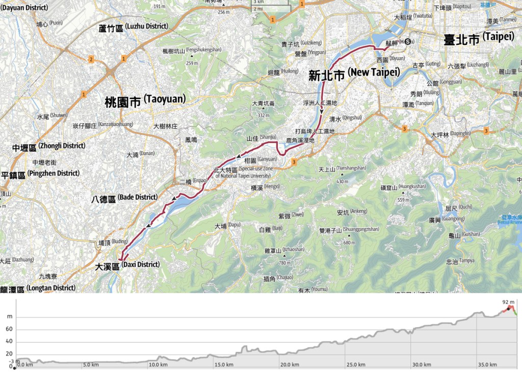
GPX file available here on Outdoor Active. (Account needed, but the free one works just fine.)
If you enjoy what I write and would like to help me pay for the cost of running this site or train tickets to the next trailhead, then feel free to throw a few dollars my way. You can find me on either PayPal or Buy Me a Coffee.

Such a lovely route! It is sad that these cities are no longer coordinating on the biking options.
Christie
LikeLiked by 1 person
I have faith that it’ll go back to being coordinated soon. Once the old bikes are all replaced with the 2.0 ones, the system should match up again. They’ve spread as far as Yingge now, so it should be too long before they arrive at Daxi.
LikeLiked by 1 person